Ohio History Journal
- 1
- 2
- 3
- 4
- 5
- 6
- 7
- 8
- 9
- 10
- 11
- 12
- 13
- 14
- 15
- 16
- 17
- 18
- 19
- 20
- 21
- 22
- 23
- 24
- 25
- 26
- 27
- 28
- 29
- 30
- 31
- 32
- 33
- 34
- 35
- 36
- 37
- 38
- 39
- 40
- 41
- 42
- 43
- 44
- 45
- 46
- 47
- 48
- 49
- 50
- 51
- 52
- 53
- 54
- 55
- 56
- 57
- 58
- 59
- 60
- 61
- 62
- 63
- 64
- 65
- 66
- 67
- 68
- 69
- 70
- 71
- 72
Boundary Line Between Ohio and
Indiana, Etc. 127
BOUNDARY LINE BETWEEN OHIO AND INDIANA,
AND BETWEEN OHIO AND MICHIGAN.
SPECIAL REPORTS OF T. C. MENDENHALL,
SUPERINTENDENT OF UNITED
STATES COAST AND GEODETIC SURVEY, AND A.
A. GRAHAM,
SECRETARY OF THE OHIO HISTORICAL
SOCIETY.
The Sixty-ninth General Assembly of Ohio
authorized the
Governor to cause an examination of the
boundary lines between
Ohio and Indiana and Ohio and Michigan
to be made. It has
for some time been known that these lines,
as now existing, are
incorrect, and that steps should be
taken to have them definitely
and accurately marked. In 1881 the
States of Ohio and Pennsyl-
vania, through a joint commission,
caused their common boundary
to be re-surveyed and marked by stone
posts set at intervals of
one mile, beginning at a large stone
monument near the Lake
Erie shore. The line is thus permanently
and accurately fixed,
and, hence, every division boundary of
farm or village lots accu-
rately located.
This should be done with the western and
northern bound-
aries of Ohio. The annexed reports show
in detail the Jaws
relative to them; what has been done and
what the investigation
developed:
To His Excellency, JAMES E. CAMPBELL,
Governor of Ohio:
SIR: Pursuant to your letter of
authority and instructions under date
of August 27, 1891, to " examine
into the boundary line question now pend-
ing between the States of Ohio and
Indiana and Ohio and Michigan, and
to gather such material as may be found
in relation to that matter, making
it your especial object to obtain copies
of original surveys, maps, plats,
field- notes, etc.," I have to
report as follows:
That it has been the intention of the
Ohio Historical Society, of which
I am Secretary, to publish a volume on
not only the western and northern
boundaries of Ohio, but also upon the
southern boundary; one fraught
with interest of a historical nature and
which students of history and
political economy desire to see in
compact form. This being our inten-
tion, we had gathered all material that
could be found, much of which is
not needed in this connection, but which
will be necessary in case the
Society can carry out its intentions.
This report confines itself to the
western and northern boundaries.
A. A. GRAHAM.
128 Ohio Arch. and His. Society Publications. [VOL. 4
THE WESTERN BOUNDARY.
The earliest mention of the division of the territory north-
west of the Ohio River appears in a resolution of the Continental
Congress under date of October 10, 1780, which states:
"That the unappropriated lands that may be ceded to the
United States, shall be formed into States, * * * * that
each State shall contain a suitable extent of territory, not less
than one hundred nor more than one hundred and fifty miles
square, or as near to as circumstances will admit." * * * *
On March 1, 1784, Virginia ceded to the United States her
right to the territory northwest of the Ohio River, with the
special condition that the territory so ceded should be laid out
and formed into States of the extent mentioned in the resolution
of Congress of October 10, 1780. On April 23, 1784, Congress
passed a resolution declaring that-
"So much of the territory ceded by the individual States to
the United States, as then had been, or should thereafter be
purchased from the Indian inhabitants * * * * should be
divided into distinct States as nearly as the cessions would admit
of in the following manner: That is to say, by parallels of
latitude, so that each State should comprehend from north to
south, two degrees of latitude, beginning to count from the
completion of the forty-fifth degree north of the equator, and
meridians of longitude, one of which should pass through the
lowest part of the rapids of the Ohio, and the other through the
western cape of the mouth of the Great Kanawha; but the
territory eastward of the last meridian, between the Ohio, Lake
Erie and Pennsylvania, should be one State, whatever may
be its comprehension of latitude-that which may be beyond
the completion of the forty-fifth degree between the said
meridians, shall make part of the State joining it on the
south, and that of the Ohio which is between same meridians
coinciding nearly with the parallel of thirty-nine degrees, shall
be substituted so far in lieu of that parallel as a boundary line."
By September, 1786, all the States claiming territory north-
west of the Ohio River, had ceded their claims to the United
States. The division of the territory into States came again

Boundary Line Between Ohio and
Indiana, Etc. 129
before Congress for consideration. It
was decided that the for-
mation of the territory into States,
with boundaries specified
in the resolutions of October 10, 1780,
April 23, 1784, or the act
of cession of.Virginia of March 1, 1784,
was impracticable. On
the 7th of July, 1786, Congress passed a
resolution asking from
Virginia an alteration in her act of
cession of March 1, and sug-
gested it be more in accordance with the
deed of cession made
by that State December 20, 1784. This
deed among other con-
ditions, states that-
"Upon condition that the territory
so ceded shall be laid out
and formed into States, containing a
suitable extent of territory,
not less than one hundred nor more than
one hundred and
fifty miles square, or as near thereto
as circumstances will
admit, etc.
The preamble to the resolution of
Congress of July 7 states
that-
"WHEREAS, it appears from the
knowledge already obtained of the
tract of country lying north-west of the
River Ohio, that the laying it out
into States of the extent mentioned in
the resolution of the 10th of
October, 1780, and in the conditions
contained in the deed of cession by
Virginia, will be productive of many and
great inconveniences. * * *
* * In order, therefore, that
the ends of Government may be attained,
and that the States which shall be
formed, may become speedy and sure
accessions of strength to the
confederacy: therefore,
" Resolved, That
it be and is hereby recommended to the Legislature of
Virginia to take into consideration
their act of cession, and revise the
same so as to empower the United States,
in Congress assembled, to make
such a division of the territory * *
* into distinct Republican
States
not more than five nor less than three,
as the situation of the country and
future circumstances may require.* * *
* *
On the 13th of July, 1787, Congress
passed the "Ordinance
of 1787" for the Government of the
North-west Territory. This
ordinance is in the nature of a compact
between the original
States and those that might be formed
within the territory, irre-
vocable, save by the consent of both
parties. It is therefore the
constitution or fundamental law of the
territory. Anticipating
that Virginia would accede to the
request made in the resolution
of July 7, 1786, article 5, of the
compact of the ordinance de-
clares that-
Vol. IV-9
130 Ohio Arch. and His.
Society Publications. [VOL. 4
"There shall be formed in the said
territory, not less than
three nor more than five States, and the
boundaries of said
States, as soon as Virginia shall alter
her deed of cession and
consent to the same, shall become fixed
and established as
follows, to-wit:
" The western State in the said
territory shall be bounded
by the Mississippi, the Ohio, and Wabash
Rivers; a direct line
drawn from the Wabash and Post St.
Vincent due north, to the
territorial line between the United
States and Canada, and by the
said territorial line to the Lake of the
Woods and Mississippi.
"The middle State shall be bounded
by the said direct line,
the Wabash from Post St. Vincent to the
Ohio, by the Ohio, by
a direct line drawn due north from the
mouth of the Great
Miami to the said territorial line. The
eastern State shall be
bounded by the last-mentioned direct
line, the Ohio, Pennsyl-
vania, and the said territorial line; provided,
however, and it is
further understood and declared, that
the boundaries of these
three States shall be subject so far to
be altered, that if Congress
shall hereafter find it expedient, they
shall have authority to form
one or two States in that part of
said territory which lies
north of an east and west line drawn
through the southerly bend
or extreme of Lake Michigan." * * *
By the year 1800 the territory contained
a sufficient number
of inhabitants to justify a division for
Government purposes, and
on the 7th of May, Congress passed
"Act to divide the territory
of the United States, north-west of the
River Ohio, into two
separate Governments."
This act provided that " From and
after the fourth day of
July next, all that part of the said
territory which lies to the
westward of a line beginning at the
Ohio, opposite the mouth of
the Kentucky River, and running thence
to Fort Recovery, and
thence north till it shall intersect the
territorial line between the
United States and Canada, shall, for the
purpose of temporary
Government, constitute a separate
Government, and be called
Indiana Territory."
Section 5 of this act provided that
" Whenever that part of
the said territory which lies to the
eastward of a line beginning
at the mouth of the Great Miami River
and running
Boundary Line Between Ohio and
Indiana, Etc. 131
due north to the territorial line, shall
be erected into an inde-
pendent State * * * * said line shall
become and remain
permanently the boundary line between
such State and Indiana
territory, any thing in this act to the
contrary notwithstanding."
This civil division line simply followed
the "Greenville
Treaty Line" from the Ohio River
north-easterly to Fort Re-
covery from whence it passed north to
the Canadian line. It was
never surveyed, at least no record of or
reference to such a sur-
vey can be found. It was not intended to
be permanent and in
less than three years was superseded by
the line established by
the ordinance of 1787.
In October, 1798, Israel Ludlow, a
deputy United States sur-
veyor, began the survey of Congress
(Government) lands north
of the Ohio River, lying between the
Greenville treaty line on
the west, and the Symmes' purchase and
the Virginia military
district on the east, under the act of
May 20th, 1795, under which
act all Congress lands were then
surveyed. Under this authority
Mr. Ludlow and his assistants began
their work October 11,
1798. The survey was continued, subject
to many interruptions
from Indian troubles, state of the
weather, etc. (little, if any
work being done in the winter). The
township boundaries seem
to have been completed about 1801, but
it was several years
before the subdivision could be made.
The field notes of this
survey, now preserved, note the first
meridian; the western
boundary of the eastern division of the
north-west territory, the
present western boundary of Ohio. This
was used as a base
line, and the township survey made east and west from it. The
ranges were numbered east to the Great
Miami River (Symmes'
western boundary), and west to the
Greenville Treaty line, which,
will be noticed, is the civil division
line already explained in this
report. The subjoined field notes are
those of Mr. Ludlow's
survey and are herewith attached and
made a part of this report:
132 Ohio Arch. and His. Society
Publications. [VOL. 4
COPY OF PART OF
THE FIELD NOTES AND SURVEY OF THE STATE LINE
BETWEEN OHIO AND
INDIANA FOR ABOUT SEVEN MILES
FROM STARTING
POINT. LAND SURVEYS, 1798.
The Miami River
is ten chains and fifty links wide, and the Ohio,
twenty-seven
chains wide.
Observed the
variation of the magnetic needle to be at this place,
5�
10' east.
FIELD NOTES OF
STATE LINE, OCTOBER 11, 1798.
Chains. Links.
Commenced
surveying north on a meridian from a point at
or near the
center or middle of the mouth of the Great
Miami River,
from which point a cottonwood tree
twenty inches in
diameter bears N. 87�; W. three chains
distant, another
cottonwood, ten inches in diameter,
N. bears N. 58�, W. two
chains and fifty links distant.
28 70 Rose
the banks of the Miami on the east side.
71 73 Came
to the Miami River, at which place it is four chains
and fifty-eight
links wide.
76 42
Crossed the main channel of-the Miami River, on the west
bank of which
stands a cottonwood tree, eleven inches
in diameter,
marked agreeably to the plan.
N. Started from the
cottonwood on the west bank of the river.
16 59 A
honey locust, thirty inches in diameter.
40 - Another
honey locust, three feet in diameter.
52 - Over
rich bottom land timbered with honey locust, inun-
dated in high
water. Came to a channel that in a com-
mon time the
water runs with some degree of rapidity.
55 50
Crossed the above channel which at this time was nearly
dry. Set a stake
at the south-west corner of section
No. 31, T. 1, R.
1, eastern district, and at the north-east
corner of
section No. 1, T. 5, R. 1, western district; a
honey locust
bears N. 9�, E., eighteen inches in diame-
ter,
twenty-three links distant; another honey locust,
twenty-four
inches in diameter, bears N. 581/2 �, W. 57
links distant,
notched and marked by the plan, October
11, 1798.
N. Thence north on a
meridian.
11 15 A
box elder tree eleven inches in diameter, a low rich bottom
timbered
principally with honey locust, soil of the
richest quality.
29 26 A
honey locust tree in the line.
40 - A
small improvement, about twenty acres of corn.
58 05 A
forked honey locust tree twenty-four inches in diameter
in the line.
Boundary Line
Between Ohio and Indiana, Etc.
133
Chains. Links.
77 50
Crossed a stream running north-east, another improvement
and corn field
on the east of the line.
80 -
A post, from which a black walnut tree sixteen inches in
diameter bears
N. 32� W., 20 links distant, and another
black walnut
tree fourteen inches in diameter, bears N.
54o, E. 84
links.
Land along this
mile level and of the richest quality, tim-
bered thinly
with locust, hackberry and black walnut.
Three cabins
with small improvements, 10 chains to
the west.
N. Commenced second mile north on the
first meridian, from
the south-west
corner of the first township, of first
range.
7 -
Rose a bank, high land, timbered with sugar tree, walnut
and mulberry;
the soil rich.
15 55 A cherry tree sixteen inches in diameter in the line.
29 - Two
cabins with small improvements, a stream to the west
200 links.
40 - Another
improvement and cabin.
44 05 A sugar tree inches in diameter in the line.
60 - Two
cabins and small improvements, a high hill rises 20
chains to the
west; rich level land to the east.
80 -
A red elm post with three notches from which a sugar tree
twelve inches in
diameter bears N. 57�, W. 5 links; and
a sugar tree of
the same diameter bears N. 400, E. 22
links. Notched
and numbered trees of the corners of
sections,
agreeably to the plan.
N. Saturday, 13th October. Commenced
third mile. North
from second mile
post corner, section 19 and section 30
of first
township and first range; rising small hill, much
brush or
underwood.
8 - A
sugar tree ten inches in diameter.
20 - A
water-course runs S. 20�, W.; rich land; timber, ash, elm
and sugar tree -
much underwood.
30 - Rose
a hill.
35 - Begin
to descend a hill.
41 50 A
water-course runs east.
46 08 A
blue ash tree twelve inches in diameter; rose a hill.
57 - Crossed
a water-course, runs east.
69 - Rose
a hill and begin to descend.
73 50 A
water-course 10 links wide runs S. 80�, E. and begin to
descend a hill.
80 -
A post from which a blue ash tree fifteen inches in diameter
bears S. 57�, E.
20 links, and a white ash twenty inches
in diameter
bears N. 701/2� , W., 6 links distant.
134 Ohio
Arch. and His. Society Publications. [VoL. 4
Chains. Links.
N. Commenced fourth mile north from S.
W. corner of first
township of
first R.
9 - A
water-course runs east; and begin to ascend.
17 - Rose
the hill and begin to descend.
23 69 A beech tree eighteen inches in diameter in the line, on
the
bank of a
water-course, running east.
29 58 A sugar tree sixteen inches in diameter.
38 - A water-course runs east ten links wide and
begin to ascend
a hill.
43 25
Rose the hill to a white ash tree thirty inches in diameter
and begin to
descend.
50 - A
water-course running S. E.
52 - A
blue ash tree twenty inches in diameter in the line.
65 - Rose
the hill and begin to descend.
71 - A
water-course runs N. E.; hill rising W.
76 - A
water-course runs east and begin to rise on the hill.
80 - A
post from which a sugar tree twelve inches in diameter
bears S. 32�;
E. 43 links, and a white oak of same
diameter bears
N., 21�; E., 24 links. Along this mile is
generally
broken land, the soil rich, and proper for cul-
tivation,
thinly timbered with blue ash, locust and sugar
tree-trees at
the corners numbered according to the
plan.
N. Commenced fifth mile N. from S. W.
corner of first town-
ship of first
range.
5 - Rose
a hill and begin to descend.
10 50 A
spring branch.
13 58 A
black walnut tree twenty inches in diameter, ascending.
20 - Arose
the hill--timber, oak, ash and hickory; begin a
descent.
30 - A
water-course runs east.
35 81 A
sycamore tree fifteen inches in diameter; a water-course
runs S. E.
44 - A
stream runs S. W.; begin to ascend side of a hill rising W.
51 - A
sugar tree sixteen inches in diameter; hill rising W.
61 - A
sugar tree twelve inches in diameter.
76 - Rose
the hill; land of middling quality.
80 - A
post from which a locust tree twelve inches in diameter
bears S. 26�,
E., 11 links distant, and an elm tree
six inches in
diameter bears N. 14�, E., 22 links distant.
N. Commenced sixth mile N. from the S.
W. corner of township
No. 1 of the
first range. On side of a hill rising W.
13 84 A
blue ash tree twenty inches in diameter; the hill rising W.
32 - Begin
to descend a hill; an easy descent.
48 39 A
white ash tree six inches in diameter.
Boundary
Line Between Ohio and Indiana, Etc.
135
Chains. Links.
58 -
A water-course running W.; thin land; timbered with oak
and hickory.
74 - A
water-course running W.
80 - Set
a dog-wood post from which a white oak twenty inches
in diameter
bears N. 30�, E., 27 links distant, and a
locust twelve
inches in diameter bears S. 491/2�, W., 14
links distant.
Trees at the corners numbered accord-
ing to the
plan.
The field
notes of that part of the State line, together with contiguous
sections east
and west thereof, which are copied into this book from pages
one to
fourteen, inclusive, are correctly copied from the original field notes
on file in
this office. SAMUEL WILLIAMS,
Chief
Clerk.
SURVEYOR-GENERAL'S
OFFICE, CINCINNATI, October 7, 1837.
An examination
of the foregoing notes and plat reveals no
mention of a
boundary line save in an incidental manner. The
survey of the
line as a boundary line was not part of Mr. Lud-
low's work. By
the year 1802 the population of the eastern
division of
the North-western Territory had increased to such an
extent that
application was made for admission into the Union as
a State. April
30th, 1802, Congress passed an "Act to enable
the people of
the said Territory," to form a constitution and a
State
government. * * *
The second section of this act pro-
vided that
"The said State shall consist of all the territory in-
cluded within
the following boundaries, to-wit: On the east by
the
Pennsylvania line; on the south by the Ohio River to the
mouth of the
Great Miami River; on the west by the line drawn
due north from
the mouth of the Great Miami aforesaid."
* *
It will be
noticed that the act followed the ordinance of 1787
in fixing the
boundaries of this State. The people of the eastern
division of
the Territory, through their regularly elected dele-
gates, in
November, 1802, met at Chillicothe, the capital of the
Territory, and
there formulated a constitution. The sixth sec-
tion of the
seventh article of this constitution of 1802 states that-
"The
boundaries of this State * *
* shall be *
* *
on the east by
the Pennsylvania line, on the south by the Ohio
River to the
mouth of the Great Miami River; on the west by a
line drawn due
north from the mouth of the Great Miami River
aforesaid." *
* * *
136 Ohio Arch. and His. Society Publications. [VOL. 4
Soon after the organization of the
Territory of Michigan,
doubts arose as to the line between Ohio
and Indiana Territory,
and between Ohio and Michigan Territory,
The lands south of
the Greenville Treaty line were thrown
open to settlement as fast
as they could be surveyed, the surveys
beginning as early as
1796; and in that part of the State west
of the Virginia Military
District and the Symmes' Purchase in
1798 has been noted in this
report. This survey used the western
boundary as a base line
not as a boundary line as far
north as this treaty line, a few miles
south-west of Fort Recovery and
eighty-nine miles north of the
mouth of the Great Miami, and to this
point the township bound-
aries were probably so surveyed as early
as 1800 or 1802.
The General Assembly of Ohio, January
24, 1807, passed a
resolution asking "That our
Senators and Representatives in the
Congress of the United States, be
instructed and requested to
use their influence to obtain the
passage of a law to ascertain and
define the northern boundary line of
this State and fix the same
agreeably to the provisions contained in
the sixth section of the
seventh article of our
constitution."
At this time the establishment of the
western boundary does
not seem to be considered of so much
importance and no refer-
ence is made to it, but on February 7,
1809, the desired legisla-
tion not having been secured, another
resolution was passed
stating-
"That great inconvenience has been,
and is daily, occurring
in consequence of the western and
northern boundary of this
State not being defined;"
"Therefore, be it, etc., etc.,
* *
* * to have a com-
missioner appointed on the part of the
United States, to act
jointly with such commissioner as may be
appointed on the part
of this State to ascertain, run and mark
the western and northern
boundaries thereof."
The country north of the Greenville
Treaty line was still
unsettled and partly owned by Indians,
who lived chiefly on res-
ervations, hence it was not practicable
for Congress to carry out
the desires of Ohio. December 21, 1811,
a third resolution was
passed by the Ohio Legislature, reciting
various facts; chiefly
that this part of the State being opened
to settlement by the ex-
Boundary Line Between Ohio and
Indiana, Etc. 187
tinguishment of the Indian title and
that it was becoming more
necessary that the "western and
northern boundary lines be
established."
On May 20, 1812, Congress passed an act
requiring the sur-
veyor-general, under the direction of
the President of the United
States, (as soon as the consent of the
Indians can be obtained)
to cause to be surveyed, marked and
designated, so much of the
western and northern boundaries of the
State of Ohio, which
have not already been ascertained, as
divided said State from the
Territories of Indiana and Michigan,
agreeably to the boundaries
established by an act entitled "An
act *
* * * passed
April 30, 1802."
The war of 1812 and the consequent
border troubles, as well
as the unsettled condition of Indian
affairs in the North-west
Territory, precluded the carrying into
effect the act of Congress
for some time. August 9, 1816, one of
the Ohio members of
Congress called the attention of the
commissioner of the general
land office to the act and urged that
some action be at once taken.
On the 22d of the same month the
commissioner, Josiah Meigs,
addressed a letter of instructions to
the surveyor-general, Edward
Tiffin, stating that he had been
directed by the president to au-
thorize him to have Ohio's boundary line
run and marked, and
authorizing him to engage a faithful and
skilled deputy to do
the work.
The surveyor-general engaged William
Harris, "an ex-
perienced, practical and skilled surveyor," under the following
articles of agreement:
Articles of agreement indented, made and
fully agreed upon, this 14th
day of December, in the year of our Lord
1816, between Edward Tiffin,
Surveyor-General of the United States,
of the one part, and William Harris
of the State of Indiana, of the other
part: WITNESSETH, that the said
William Harris, for and in consideration
of the covenants, terms, pro-
visions and conditions hereinafter expressed,
and according to the true
intent and meaning thereof, doth hereby
covenant and agree with the said
Edward Tiffin, in his capacity
aforesaid, that he said William Harris,
will faithfully lay out and survey, and
mark in his own proper per-
son, with the assistance only of such
chainmen and axmen as may be neces-
sary, being first duly sworn, agreeable
to the laws of the United States and
such instructions as he may receive from
the surveyor-general, the
138 Ohio Arch. and His. Society Publications. [VOL. 4
boundary line from Fort Recovery, due
north, agreeable to the true
meridian so far as that a line due east
from the most southerly extreme of
Lake Michigan will intersect it; also a
line due east from such southerly
extreme of Lake Michigan to Lake Erie,
or the straits, etc., etc. And that
he will also carefully and exactly
ascertain by lunar observations the geo-
graphic position of the said southerly
extreme of Lake Michigan; and also
the position, in like manner, of the
point where the said east line shall
strike Lake Erie or the straits, etc.;
and that he will make out three neat
and accurate plats of said lines with
their true description and copies of
field notes and make return thereof as
soon as he properly can, not to be
exceeding six months from the date
thereof.
And the said Edward Tiffin, in his
capacity aforesaid, covenants and
agrees that on the completion of the
work aforesaid in manner aforesaid,
there shall be paid to the said William
Harris as a full compensation for
the whole expense of surveying and
marking the said lines, making his
lunar observations and drawing off the plats
and descriptions as aforesaid,
five dollars for every mile, and part of
a mile actually run and marked, ran-
dom line and effects not included,
provided no member of Congress have
any part in this contract.
In testimony whereof, the parties to
this indenture have hereunto set
their hands and seals, the day and year
first above written.
EDWARD TIFFIN. [SEAL]
WILLIAM HARRIS. [SEAL]
Signed, sealed and acknowledged before
us:
A. BOMNE,
SAMUEL WILLIAMS.
The attached letter and outline plat of
Mr. Harris, dated
September 8, 1817, seems to be a
preliminary report, which he
completes in detail, as relates the
western boundary, later-the
same year. The letter and outline plat
are herewith attached
and make part of this report.
CINCINNATI, September 8, 1817.
DEAR SIR: You will find inclosed a
sketch of the State line, which, I
believe, is laid tolerably correct. A
complete return I shall not be able to
make for some time in consequence of
having part of my work to correct.
It appears, by what observations I have
been able to make, that the varia-
tion of the compass decreases in going
north nearly in the same proportion
as in going east. The west boundary of
the State of Ohio was run (the
fore part of last June) when it rained
and was cloudy weather for nearly
three weeks, in consequence of which I
was not able to make the neces-
sary allowances, and shall have the line
to run over again. After I left
Chillicothe last winter I fell in
company with a gentleman from Detroit,
who appeared to be well acquainted with
the country which the State line
Boundary Line Between Ohio and Indiana, Etc. 139
passes through. He informed me that it
would be impracticable to run
the line in the spring of the year on
account of the great number of
swamps which I would have to pass
through. In consequence of this
information, I delayed the business much
longer than I would have done.
By actual experiment I found the country
almost impassible for horses at
any season of the year. By means of an
Indian guide I was able to send
my horses around the swamps; twice they
were absent from us between
two and three days. I am in hopes that
the delay in running the line will
be no inconvenience to the United
States; to individuals I am sure it will
not be, for neither line interferes with
any settlement. I shall complete
my work as soon as my health will admit.
I have had a slight touch of the
fever and a very bad cold since I left
the woods, and have been much
afflicted with rheumatism for six or
seven weeks past. I am now getting
much better and am in hopes will be able
to return to the woods in a
few days.
I am, with the greatest respect, your
most obedient,
WILLIAM HARRIS.
MR. EDWARD TIFFIN, Surveyor General.
In 1816 the Territory of Indiana applied
for admission into
the Union, and on April 19, 1816,
Congress passed an act to
"Enable the people of the Indiana
Territory to form a Constitu-
tion and a State Government, etc."
That part of section two
relating to the eastern boundary is as
follows:
"And be it further enacted, that
the said State shall consist
of all the territory included within the
following boundaries,
to-wit: Bounded on the east by the
meridian line which forms
the western boundary of the State of
Ohio. * * *
"Provided, that the convention
hereafter provided for, when
formed, shall ratify the boundaries
aforesaid; otherwise they
shall remain as now prescribed by the
ordinance for the govern-
ment of the territory north-west of the
River Ohio."
Under this act a constitutional
convention met at Corydon,
the territorial capital, and formulated
a constitution. On the
question of the eastern boundary section
seventeen, of article
seventeen, reads:
"In order that the boundaries of
the State of Indiana may
more certainly be known and established,
it is hereby ordained
and declared that the following shall
be, and forever remain, the
boundaries of the said State, to-wit:
Bounded on the east by
140 Ohio Arch. and His. Society Publications. [VOL. 4
the meridian line which forms the
western boundary of the State
of Ohio." * * *
In 1851 a new constitution (the present
one) was adopted.
Section 221, of article 14, relates to
the boundaries of the State,
and is as follows:
" In order that the boundaries of
the State may be known
and established it is hereby ordained
and declared that the State
of Indiana is bounded on the east by the
meridian line which
forms the western boundary of the State
of Ohio." * * *
Nothing further appears regarding the
western boundary
until 1835 or 1836, when doubts arose
concerning the point on
the Ohio River at which the boundary
between Ohio and Indiana
began. Commissioners were appointed on
the part of each State
to examine into and mark this point, and
also to examine the
boundary line a short distance north.
On the 28th day of February, 1837, Mr.
Hughes, from the
select committee on that subject, reported
the following preamble
and resolutions, which were read and
laid upon the table, to-wit:
"The select committee, to which was
referred the communi-
cation of the Governor on the subject of
a boundary line between
the States of Ohio and Indiana, have had
the same under con-
sideration and report the following
preamble and resolutions:
"WHEREAS, There exists, at this
time, doubts respecting the point on
the Ohio River at which the line between
the States of Ohio and Indiana
commences, and as difference of opinion
exists between the citizens of the
two States as regards their true
boundaries; and
"WHEREAS, By joint resolution, the
General Assembly of the State of
Indiana has authorized the Executive of
said State to appoint a surveyor
and commissioner, on the part of the
said State, to act in conjunction with
a similar commissioner on the part of
the State of Ohio; therefore,
"On December 31, Mr. Harris
received instructions how to run the line
between Ohio and Indiana, where not
surveyed, and between Ohio and
Michigan. Mr. Harris completed his work
on both boundary lines in 1817.
That part between Ohio and Indiana began
on the south at the intersection
of the western line running north from
the mouth of the Great Miami
with the Greenville Treaty line,
eighty-nine miles from the mouth of the
Miami. The attached plat is from a copy
of Mr. Harris' survey, now on file
in the State Auditor's office. It will
be noticed it starts on the Greenville
Treaty line, south of which was surveyed
by the land surveys under the act
Boundary Line Between Ohio and
Indiana, Etc. 141
of 1796. Mr. Harris' letter accompanying
the plat seems to indicate a sur-
vey of the entire line, but the plats
are for that portion indicated.
"Resolved, by the General
Assembly of the State of Ohio, That
the
Governor be, and he hereby is,
authorized to appoint one commissioner on
the part of the State of Ohio, who, in
conjunction with one appointed by
the Governor of Indiana, shall meet at
the town of Lawrenceburg, in the
State of Indiana, at such time as may be
appointed by the Executive of
Ohio, who, after having taken an oath,
faithfully and impartially to dis-
charge the duties required of them, as
set forth in the resolution of the
General Assembly of the State of
Indiana, and the aforesaid commissioners
and surveyor shall make out three
certified copies of the survey, made and
directed, one copy of which shall be
deposited with the Secretary of State,
of the State of Ohio, and one copy with
the Surveyor-General of the United
States, at Cincinnati; and the
commissioner on the part of the State of Ohio,
shall be entitled to receive the sum of
three dollars per day, for each day
whilst employed in the discharge of the
duties required of him, and three
dollars for each twenty-five miles in
going to, and returning from, the said
line; and the surveyor shall be entitled
to receive two dollars per day as
half of his compensation, and the
Governor of the State of Ohio is hereby
authorized to pay the same out of the
contingent fund.
"Resolved, That the Governor of the State of Ohio be directed to
transmit a copy of these resolutions to
the Governor of the State of
Indiana, and likewise inform his
Excellency of the time of meeting of the
said commissioners."
Under authority of the foregoing
resolution, Joseph Vance,
Governor of Ohio, appointed M. T.
Williams to represent Ohio;
the Governor of Indiana appointed John
A. Watson. These
commissioners met at Lawrenceburg,
Indiana, in November,
1837, and appointed Nathaniel L.
Squibb, surveyor, to ascertain
and designate the true starting point of
the boundary line on the
Ohio. After completing his work he made
the following report
to the commissioners, and marked on the
report as "Exhibit B."
To Mr. M. T. Williams. of Ohio, and Mr.
John A. Watson,
of Indiana, commissioners appointed to
establish the line between
the States of Ohio and Indiana, and
place monuments on the
same near the mouth of the Great Miami
River:
I, Nathaniel L. Squibb, being employed
as surveyor by the above-named
gentlemen, do hereby certify, that in
obedience to their orders, after being
duly sworn, I proceeded to examine
several miles of the State line in the
timbered land, where the section corners
could be found by the field notes,
to determine the general bearing of said
line; that after satisfying myself
with regard to the general course or
variation allowed on said line, I com-
142 Ohio Arch. and His. Society
Publications. [VOL. 4
menced
at the N. E. corner of section 25, and the S. E. corner of section 24,
T. 6,
R. 1, W., which point is also the corner of sections 19 and 30 in the
State
of Ohio, and ran a due south course (allowing a variation of 4� 40 E.)
to the
north bank of the Ohio River in the following manner, to-wit .
Chains.
Links.
70 40
Beginning at the point above mentioned and running south
70
chains, 40 links, to a stake in the tow-path bank of
the
White Water canal, from which the N corner of I.
Hayes'
stone chimney bears S. 82� W., 1 ain,
42 links
distant.
79 24
And a stake in the line bears N. 2 chains; 94 links, to a stone
supposed
to be the S. E. corner of section 25, and the
77 75
N. E. corner of section 36, T. 6. R. 1, W., thence to a
honey
locust twenty-two inches in diameter, to a stake
79 50
on the top of the bank at the island gut, supposed to
be the
S. E. corner of section 36, T. 6, R. 1, W.
5 - To
a soft maple thirty-six inches in diameter.
51 12 To
a cotton-wood eighteen inches in diameter.
55 50 To
a stake on the N bank of the Miami River, from which
a
cotton-w in
diameter bears N. 78� E.,
40
links distant, cotton-wood
bears S. 78� W., 71
links
distant.
62 37
To a sycamore eighteen inches in diameter on the S. bank
of the
Miami.
80 - To
a mile stake in the line.
11 87 To
a stake on the N. bank of the Miami.
31 56 To
a cotton-wood on the S. bank of the Miami.
46 56 To
a stake on the N. bank of the Ohio River below the
mouth
of the Great Miami, from which a cotton-wood
fifteen
inches in diameter bears N. 17� W., 66 links dis-
tant,
and a cotton-wood twenty-two inches in diameter
bears
S. 251/2� W., 1 chain, 22 links, and a cotton-wood
fifteen
inches in diameter bears S. 89� W., 40 links
distant.
NATHANIEL
L. SQUIBB, Surveyor.
HARTFORD,
DEARBORN COUNTY, IND., November, 1837.
To this
report Mr. Squibb makes the following affidavit
marked
"A."
State
of Ohio, Hamilton County:
On the
21st of November, A. D., 1837, personally appeared before the
undersigned,
a Justice of the Peace, of the county and State aforesaid,
Nathaniel
L. Squibb, appointed surveyer of the boundary line between the
States
of Ohio and Indiana, from the mouth of the Great Miami River to
Boundary Line Between Ohio and
Indiana, Etc. 143
the point where the road from
Lawrenceburgh to Elizabethtown crosses to
said State line, under joint resolutions
of said States, heretofore passed,
who, being first duly sworn, on his oath
says that he truly, faithfully and
impartially discharged his duties as
such surveyor, and correctly report his
proceedings to the best of his knowledge
and ability.
Sworn to and subscribed this 21st day of
November, A. D., 1837.
NATHANIEL L. SQUIBB.
SAM'L W. HENRY [SEAL.]
Justice of the Peace.
The report of the commissioners is as
follows:
To His Excellency, JOSEPH VANCE, Governor of the State of Ohio:
The undersigned commissioners appointed
under the joint resolutions
of the Legislatures of the States of
Ohio and Indiana, to survey the
boundary line between said States at the
mouth of the Great Miami River,
respectfully report-
That on the 21st day of November, A. D.,
1837, they entered upon the
discharge of their duties, by convening
at Lawrenceburgh and appointing
Nathaniel L. Squibb, surveyor, who was
sworn agreeable to the provisions
of the joint resolutions, as will appear
by affidavit herewith filed, marked
"A." Your commissioners
further report that they, with the said Nathaniel
L. Squibb, assisted hy Joseph Gest,
Surveyer of the city of Cincinnati, on
the said 21st day of November, A. D.,
1837, commenced the survey of said
line, and on the -- day of said month
and year, completed the survey of
said line and marked the same as
originally surveyed by Israel Ludlow,
Deputy Surveyor of the United States, in
October, 1798, as will more fully
appear by the report of N. L. Squibb,
herewith filed and marked "B."
And your commissioners further report
that in fixing said line, they
located it to correspond as nearly as
possible and as could be ascertained
with the field notes of the said survey
of Israel Ludlow, made in 1798,
a copy of which will be found in
document marked "C", as also a map of
the State line and the sectional surveys
east and west. These we consider
valuable documents to be filed and
preserved by the States, and for these,
as well as for other practical
information furnished us in the discharge
of our duties, we are indebted to Samuel
Williams, Chief Clerk in the office
of the Surveyor-General, at Cincinnati.
Your commissioners further report that
on the 27th day of November,
A. D., 1838, they erected on said line
at the points named in the report of
Mr. Squibb, above referred to and marked
"B," two monuments of solid
freestone, nine feet in length, each
resting three feet below the surface of
the ground on a square block of
freestone, embedded in a cubic yard of
broken stone to protect them from the
action of the frost. The monu-
ments each weighed about five thousand
pounds and it is believed will be
impervious to the action of the frost
and very durable. For the shape,
144 Ohio Arch. and His. Society Publications. [VOL. 4
plan and inscription of the monuments,
reference may be had to paper
marked "D."
Your commissioners further show that
they were qualified agreeably
to the resolutions of the States as will
appear by affidavit filed and
marked " E."
Your commissioners further report that
in the survey and erection of
monuments as aforesaid, they have
expended, exclusive of their services as
commissioners, the sum of$ -, as will
appear by vouchers Nos. 1, 2, 3, etc.
M. T. WILLIAMS,
Commissioner on the part of Ohio.
JOHN A. WATSON,
Commissioner on the part of Indiana.
One of the stone monuments referred to
in the foregoing
report was placed on the west bank of
the Miami River, at its
junction with the Ohio; the other on the
right bank of the canal
where it crosses the State line. The
paper marked "D" in the
report is not on file in the Auditor's
office, and can not now
be found.
This last survey and report completes
all that has been done
by the State regarding Ohio's western
boundary. Recapitulating,
it shows that the first survey of this
line was made in 1798, in
connection with the land surveys, when
the line (meridian) was
considered as a base line of the
survey, and not as a boundary
line between the two respective States.
Then in 1817, under
authority of Congress, as a division line
was surveyed by William
Harris, under the direction of Edward
Tiffin, Surveyor-General.
It is not clear that he surveyed all the
line, but only that part
north of the Greenville Treaty line,
beginning at a point eighty-
nine miles north of the mouth of the
Great Miami River. This
seems more evident when we see that in
1837 a Commission
is appointed to ascertain the proper
point on the Ohio, at the
mouth of the Great Miami, where this
line should begin. This
Commission, employing a competent
surveyor, fixes the point on
the west bank of the Miami by erecting a
stone, suitably in-
scribed; and, also, a second one only a
few miles further north
on the same line. This being done no
further effort is made to
ascertain and accurately mark this
boundary. It is time now
that it should be done. In 1881, a joint
Commission, on the
part of Pennsylvania and Ohio, began
such a work on the
Boundary Line Between Ohio and
Indiana, Etc. 145
boundary between those States,
completing it in 1883. Its
report is herewith appended. It is
complete. Appropriate stone
monuments at certain intervals on the
line, securely and appro-
priately mark the line. The line was not
changed but fixed
beyond dispute, and those who own land
in either State know to
a certainty in which commonwealth their
possessions lie. This
should be done on the western boundary
and thereby settle the
question.
The 69th General Assembly of Ohio took
steps at the
adjourned session in 1891 to have the
western and northern
boundary lines examined and the errors,
if any existed, noted.
To this end the Governor was authorized
by resolution "to
obtain the United States Coast and
Geodetic Survey to accurately
ascertain and mark the boundary lines
between the states Ohio and
Indiana, and Ohio and Michigan *
* * * ."
Prof. T. C. Mendenhall, Superintendent
of the U. S. Coast
and Geodetic Survey upon request of the
Governor, sent two
assistants in the summer of 1891 to the
line. His report, as well
as those of the assistants, is here
appended.
U. S. COAST AND GEODETIC SURVEY,
OFFICE OF THE SUPERINTENDENT,
WASHINGTON, D. C., November 27th,
1891.
HON. JAS. E. CAMPBELL, Governor of Ohio:
DEAR SIR: I have the honor to transmit
herewith the reports of
Cephas H. Sinclair, Assistant, and
George R. Putnam, Aid, U. S. Coast and
Geodetic Survey, relating to recent
determination of the longitude of three
points on the boundary line, as accepted
at present, between the states of
Ohio and Indiana.
On being requested by you to determine
whether or not this line was
seriously in error, it was decided that
the question could be most readily
and cheaply answered by telegraph
longitude determinations at three
points on or near the line. The line is
defined as a meridian passing
through the mouth of the Big Miami
River, and therefore if correctly run
the longitude of all its points must be
the same. To re-run the line would
have involved a large expenditure of
time and money, and it was, evidently,
not worth while to undertake this until
the magnitude of the error, if any
existed, should be determined.
The determination of the longitude of
three points, one near each
extremity of the line and one near its
middle point, would not require
more than a few weeks, nor cost more
than a few hundred dollars and the
Vol. IV-10
146 Ohio Arch. and His. Society Publications. [VOL. 4
accuracy of the method is sufficient for
a preliminary examination of this
character.
By exchanging signals on three nights,
but without exchange of
observers for elimination of personal
equation, it was estimated that the
error in the determination of the
positiou of a point would not be greater
than 300 feet.
An examination of the reports herewith
submitted will show that the
error is probably considerably smaller
than this.
It was necessary in this case to fix the
astronomical station at some
town or village in which telegraph
connection with St. Louis, the base
station, was available and which was as
near the supposed boundary line as
possible. The following points were
therefore chosen after a careful ex-
amination by Mr. Putnam of the
facilities offered by several proposed
stations at the northern end of the
line: Elizabethtown, Ohio, Union City,
Indiana and Butler, Indiana.
While in none of these was the observing
station exactly on the line,
in all it was so near that the error
arising from the connection, which was
carefully made in all cases, must be
insensible.
The initial monument at the mouth of the
Miami River is not now
visible, but that next north of it was
found and is assumed to represent the
initial point in longitude.
The result of the investigation is that
the assumed boundary line is
about one mile too far to the east at
Butler, Indiana, and about three-
quarters of a mile too far in the same
direction at Union City. It is also
clear that it is a zigzag line, now
deflecting toward the east and again to the
west, the probability being that on the
whole it is too far to the east.
The condition of the line, as
ascertained by Messrs. Sinclair and
Putnam, shows that whatever may be done
in reference to the location of
the line, it is imperative that early
attention should be given to its better
marking. Only a single State monument was
found by these gentlemen,
and it is evident that in many places
the location of the boundary depends
as much on tradition as any thing else.
Among some of the older States
the failure to properly establish and
mark boundary lines has given rise to
vexatious dispute and irritation on both
sides; leading often to actual con-
flict, and nearly every generation has
its tnrn at this. Ohio and Indiana
should seek an early settlement of this
question through the establishment
of a joint commission, empowered to establish
and mark with suitable and
permanent monuments the line separating
these two great States.
I would respectfully urge, therefore,
that this matter be brought to the
attention of the next General Assembly
and that such a course be recom-
mended for their consideration.
I am yours, faithfully,
T. C. MENDENHALL, Superintendent.
Boundary Line Between Ohio and
Indiana, Etc. 147
U. S. COAST AND GEODETIC
SURVEY,
WASHINGTON, D. C., November. 5, 1891.
DR. T. C. MENDENHALL, Superintendent
U. S. Coast and Geodetic Survey,
Washington D. C.
SIR: I have the honor of submitting to
you the following report on
the determination of the difference of
longitude of St. Louis, Mo., and
three points on the Ohio and Indiana
boundary, for the purpose of ascer-
taining the deviation of that boundary,
which was intended to be a true
north and south line, from a true
meridian. This method of procedure is
based on the well-known fact that the
longitude of all points on a true
meridian line is the same.
In compliance with instructions dated
October 2, I went to Holton,
Indiana, and conferred with Assistant
Mosman in regard to boundary
monuments and marks near the south end
of the line, which he had
examined. He informed me that the
initial stone of the survey, set near
the mouth of the Big Miami River to mark
the south end of the line, was
covered with deposits from the overflow
of the river, but that at sometime
between 1855 and 1860 it was unearthed
by railroad engineers after digging
ten or fifteen feet below the surface of
the ground. Since then it has been
lost to sight, and may now be under many
feet of detritus, or washed out
entirely by changes in the stream.
On the pike leading to Lawrenceburg,
nearly a mile south-west of
Elizabethtown, Ohio, at the State line
crossing, is a large, round stone, two
feet in diameter at the base and fully
eight feet above ground, tapering
to about fourteen inches in diameter
near the top, which terminates
in a conical cap, the entire monument
being one stone. It was so covered
with hand-bills that all of the
inscription was not laid bare, but the date,
1837, was exposed.
With the exception of this stone I did
not hear of any authentic
boundary marks other than section
corners and posts set on the railroads
to mark the State line, which are of
comparatively recent date, but were
sufficient for the purpose of making the
examination desired.
The large monument referred to, was
selected as the initial station for
the longitude work, as the probability
is that it can not be out of position
materially, since it is within two and a
quarter miles of the south end
of the line.
It was necessary to locate the longitude
station at Elizabethtown in
order to be near a telegraph station,
but connection was made with the line
monument by means of a theodolite and
two measurements with a thirty
metre steele tape.
Interchanges of longitude signals were
made with Mr. G. R. Putnam at
St. Louis, who co-operated with me in
this work on October 14, 16 and 17.
No exchange of observers was made on any
of the lines, but the personal
148 Ohio Arch. and His. Society Publications. [VOL. 4
equation derived from five primary lines
during the last season was applied
to each result.
Latitude was determined with zenith
telescope No. 6, by seventy-four
observations on twenty-one pairs of
stars during four nights.
Two meridian stones were placed in Wayne
St. 130.65 metres apart, and
the astronomical station was referred to
the Presbyterian Church, Methodist
Church, and to the cupola of the public
school.
The next station selected was Union
City, which lies in both States.
The boundary is shown here by the State
line pike and a prominent post at
the railroad crossing, but with the
exception of section corners, there are
no other marks near.
A convenient location was found for the
station near the depot telegraph
office and boundary post on the
railroad, and signals were interchanged
with St. Louis, October 22, 24 and 25.
Latitude was determined by fifty-two
observations on sixteen pairs of
stars during four nights, with zenith
telescope No. 6.
The astronomical station was referred to
the State line post on the rail
road, to the cupola of the public school
erected in 1891, to the M. E.
Church and the Disciples Church.
While at Union City, I transferred the
meridian to the State line road
by means of the theodolite. A point was
assumed as the center of the road
by looking south several miles along the
road; the theodolite was set over
this point and directed as nearly as
could be by the eye along the center
of the road, and it was found to deviate
nearly 11/4� to the east of north.
This deviation may be in error five or
ten minutes, owing to the uncertainty
in locating the center line of the road.
The third station was selected at
Butler, DeKalb county, Indiana, after
an examination had been made by Mr.
Putnam of all the telegraph stations
near the State line from the north end
as far south as the crossing of the
Nickel Plate R. R., abreast of Ft. Wayne,
Ind.
Although Butler is 3.7 miles west of the
boundary, connection was
easily made with two posts near the
railway crossing, by measurements
with a steel tape along the L. S. &
M. S. R. R., which runs straight for more
than three and one-third miles.
The station was located on grounds of
the L. S. & M. S. R. R. about
eighty metres north, and a little west
of the passenger depot, for conven-
ience to the telegraph office.
Longitude signals were exchanged with
St. Louis, October 28, 29 and 31.
Latitude was determined by fifty-four
observations on eighteen pairs
of stars. The astronomical station was
referred to the Lutheran, Disciples,
Methodist and Winebrennerian churches;
connection was made with two
boundary posts near the railroad
crossing, by two measurements, with
a thirty-metre steel tape. The following
table shows the results of three
determinations of longitude, and the
deviation of the State line to the
eastward of the south station:
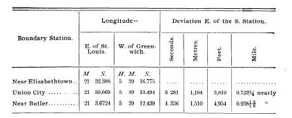
|
Boundary Line Between Ohio and Indiana, Etc. 149 |
|
|
|
While at Union City, I was informed that the line turned towards the west a few miles north of that point. It is evident that the line is an irregular one, sometimes bending east, then curving west, as would probably be the case with any of the meridians traced out by the needle many years ago. That the deviation towards the east is not uniform, is shown by the amount the line differs at Union City and at Butler from the south station. In a distance of 1� 03' along the meridian, the deviation to the east is 1,164 metres (3,819 feet), while in a distance of 2� 17' it only amounts to 1,510 metres (4,954 feet), or a little over 1,000 feet more. If the deviation was regular, it would have been 2.17 times as great, or 2,526 metres (8,287 feet) over one and one-half miles. Moreover, the deviation of the State line road, at Union City, of one and one-fourth east of north, if constant from the south station, would be, at Union City, about 8,300 feet, or over one and one-half miles, and at Butler about 18,000 feet, nearly three and one-half miles. These facts point to the irregular character of the boundary. The examination proves that while the line is not a true meridian, it is not in error ten or twelve miles as is supposed by many. Should the line be traced out as a true meridian from the south end, it would probably cut from Indiana a strip of territory amounting to nearly 100 square miles in area. Mr. C. Y. Dixon was associated with me as recorder, and rendered efficient service. The field work was completed on October 31, and by November 3 all the members of the party were in Washington. Fortunately, the weather was quite favorable for field operations, so that the entire time consumed from the date Mr. Putnam began his examinations of telegraph stations and boundary marks at the northern end of the line, until the parties reached Washington, was less than a month: Our work was very much facilitated by the promptness of the Western |
150 Ohio Arch. and His. Society
Publications. [VOL. 4
Union Telegraph
officials in connecting our astronomical stations with
their wires, and
making up the circuits for the interchange of longitude
signals.
My thanks are
due the citizens of Union City for their assistance in the
preparation of
the astronomical station.
Yours,
respectfully,
(Signed) C. H. SINCLAIR, Assistant.
U. S. COAST AND
GEODETIC SURVEY,
WASHINGTON, D.
C., Nov. 6th, 1891.
DR. T. C. MENDENHALL,
Superintendent
United States
Coast and Geodetic Survey:
SIR: I herewith
submit report of observations made at St. Louis, Mo.,
for the purpose
of determining the longitude of three stations on or near
the Ohio-Indiana
boundary line, in co-operation with Assistant C. H. Sin-
clair. I have
already reported the result of an examination of the northern
portion of the
boundary line. On completion of this examination I went
to St. Louis,
reaching there the morning of October 10. On account of
delay in
receiving instruments and preparing them for use, it was impossible
to commence
observations before October 13. Observations were com-
pleted October
31, signals having been exchanged on nine nights; five
nights were lost
on account of time required to change stations, four
nights on
account of bad weather at one or both stations, and one night on
account of
mistake of operator. At St. Louis there was but one night that
was too cloudy
for time observations, though on several occasions the very
smoky condition
of the atmostphere was quite unfavorable to good work.
Latitude
observations were made on seveal nights simply for practice.
Prof. Pritchett
kindly offered all the facilities of the Washington
University
Observatory, and the east pier in the transit room was occupied.
This pier is
53.5 inches or 0.004 seconds of the time east of the west pier,
or C. and G. S.
station of 1881. No observations were made for personal
equation, but
the value derived from five lines (exchange of observers) in
1891 was used.
The following
table gives simply the results obtained; as these results
will be
discussed by Mr. Sinclair in his report no further comment is made
here:
West of
Greenwich.
H. M. S.
Longitude, St.
Louis, Mo., (Transit 1881) .................6 00 49.163
State Line
Monument, Elizabethtown, 0......5 39 16.775
" " " Post, Union City, Ind..............5 39
13.504
" " " Butler,
Ind ..................5 39 12.448
|
Boundary Line Between Ohio and Indiana, Etc. 151 |
|
|

152 Ohio Arch. and His. Society Publications. [VOL. 4
THE NORTHERN BOUNDARY.
The sessions of Virginia and the
ordinance of 1787 not only
defined the eastern and western
boundaries of the three States
to be first formed in the north-west
territory, but also provided
for the boundaries of two additional
States, should Congress de-
cide upon their formation in the
northern part of the territory.
Article 5 of the ordinance of 1787
provided for this division in
the following language:
* * * "Provided, however, and
it is further understood
and declared, that the boundaries of
these three States shall be
subject to be so far altered, that if
Congress shall hereafter find
it expedient they shall have authority to
form one or two States
in that part of the said territory which
lies north of an east and
west line drawn through the southerly
bend or extreme of Lake
Michigan." * * *
April 30, 1802, the Congress of the
United States passed an
act "to enable the people of the
eastern division of the territory
(east of a line drawn due north of the
mouth of the Great
Miami River, already cited in this
report) to form a Constitution
and a State Government." Section 2
of this act defines the
boundaries of the State; the north
boundary in these words:
* * *
"And on the north by an east and west line drawn
through the southern extreme of Lake
Michigan, running east,
after intersecting the due north line
aforesaid, from the mouth
of the Great Miami River, until it shall
intersect Lake Erie or
the territorial line; thence with the
same, through Lake Erie to
the Pennsylvania line aforesaid." *
* *
The Convention elected to frame the
Constitution for the
State, under the act of April 30, met at
Chillicothe in November,
1802. The 6th section of the 7th article
of that Constitution
defined the boundaries of the State; the
northern boundary as
follows:
* * *
" And on the north by an east and west line drawn
through the southern extreme of Lake
Michigan, running due
east after intersecting the due north
line aforesaid from the
mouth of the Great Miami until it shall
intersect Lake Erie or
the territorial line; and thence with
the same through Lake
Boundary Line Between Ohio and
Indiana, Etc. 153
Erie to the Pennsylvania line aforesaid;
provided, always, and it
is hereby fully understood and declared
by this Convention that,
if the southerly bend or extreme of Lake
Michigan should ex-
tend so far south that a line drawn due
east from it should not
intersect Lake Erie, or if it should
intersect the said lake east of
the mouth of the Miami of the Lake, then
and in that case, with
the assent of the Congress of the United
States, the northern
boundary of this State shall be
established by, and extend to a
direct line running from the southern
extremity of Lake Michi-
gan to the most northerly cape of the
Miami Bay, after intersect-
ing the due north line from the mouth of
the Great Miami River
aforesaid; thence northeast to the
territorial line and by the said
territorial line to the Pennsylvania
line."
This Constitution was soon after sent to
Congress, where it
was referred to the proper committee.
When the clause relative
to the northern boundary was considered
it was decided that
"the proviso contained in the 6th
section of the 7th article of
the Constitution of the State of Ohio,
depending on a fact not
yet ascertained, and not being submitted
in the shape of other
propositions from the Convention to
Congress, the committee
have thought it unnecessary to take it,
at this time, into con-
sideration."
The act of April 30, 1802, did not
authorize any boundary
save that designated in the ordinance of
1787. The maps of that
period gave the location of Lake
Michigan other than its true
position, hence no one contemplated that
an error might place
the boundary line, if made strictly in
accordance with the ordi-
nance of 1787, or the act of 1802,
further south than was intended
in the ordinance. Mitchell's map, then
considered good authority,
located the northern boundary line so
that its eastern extremity
passed above Lake Erie altogether and
struck the Detroit River
immediately above the upper extremity of
the lake. That such
would be the north boundary of Ohio was
unquestionably the
intention of Congress at the time.
Lewis' map of the United
States, published as late as 1815;
Vance's map, published in 1818,
and many other maps, of an earlier or
later period, show the
northern boundary of Ohio to be this
line. When the Conven-
tion met in Chillicothe, such was the
prevalent opinion. While
154 Ohio Arch. and His. Society Publications. [VOL. 4
the Convention was in session, some one
doubted the accuracy
of the maps, and the question arose as
to what point on Lake
Erie a direct line east from the
southern extremity of Lake
Michigan would touch. It is also said
that while this subject
was under discussion information was
received through a trapper,
or Indian trader, that Lake Michigan
extended much further
south than was commonly supposed, and as
delineated on the
maps of the period. The Maumee River and
its outlet into
Lake Erie was considered as of vital
importance. At that time
rivers were the highways of commerce,
and their outlets, espec-
ially into the lakes or ocean, looked
upon as valuable sites for
centers of trade. The Maumee
River, while not navigable for
boats of a heavy burden, was, above and
below the rapids, well
adapted to boats of light pattern,
especially flat-boats and
pirouges of commerce, the freight trains
of that day. The river
also drained a very important extent of
country, and at its head
stood the old and well-established
trading post of Fort Wayne.
The subject was of too much interest to
be overlooked. Consid-
ering the evident intent of the
ordinance of 1787 and also that of
Congress, from its knowledge of the
country and the desirability
of the outlet of the Maumee River, the
Convention adopted this
proviso, contained in the 6th article,
stipulating, "with the assent
of Congress," that the boundary should be the line terminating
on the north cape of the Maumee Bay.
Another question had
no little influence in securing this
action. It was argued by
some of the delegates that if the
southern extremity of Lake
Michigan was as far south as claimed by
those who denied the
accuracy of the maps, a direct line east
to Lake Erie would fall
so far south of that body of water that
it would not intersect the
northern territorial line in the lake
and that there was a possi-
bility that it might not touch the lake
at all; also, that if it did,
it would be at a point so far south that
if the line continued east-
ward to the Pennsylvania line it would
cross the northeastern
part of the proposed State (Ohio) and
there cut off a part of the
State, leaving it without any
jurisdiction or belonging to the
territory north of Ohio. Obviously, it
was argued with good
reason, no such probabilities as the
foregoing were contemplated
by Congress when adopting the ordinance
of 1787, nor the act of
Boundary Line Between Ohio and
Indiana, Etc. 155
April 30, 1802. Arguing from all these
tenable points, the Con-
vention considered itself justified in
the insertion of the 6th
section of the 7th article of the State
Constitution. The Consti-
tution was presented to Congress in
December and referred to
the proper committee. This committee
decided, as has been
noted, that this section not being
presented separately and its
decision being based upon a fact not yet
known, they were not
called upon to adopt any report on that
point.
Political influences had much to do with
the creation and
admission of Ohio into the Union.
Without stopping to discuss
these it is only sufficient to say that
in place of the usual resolu-
tion to admit the State, Congress passed
on February 19, 1803,
"An act to extend the laws of the
United States over the State
of Ohio." The preamble of this
resolution recites, "That the
State of Ohio had formed a Constitution
and State Government,
and that thereby became one of the
United States of America."
The passage of this act accepted the
Constitution as adopted
by the Convention, and hence Ohio's
claim to her northern
boundary lies-
First-In the evident intent of the ordinance of 1787, and
by the act of 1802, and
Second- The acceptance of its
Constitution by the General
Government.
That part of the north-west territory
lying north of the Ohio
boundary was attached to Indiana
territory, which comprised all
the territory west of Ohio to the
Mississippi River. Its seat of
Government was Vincennes, on the Wabash
River. The distance
from Detroit and other remote
settlements in this part of the
territory to Vincennes, made exceedingly
inconvenient and diffi-
cult the transaction of public business.
January 11, 1805, Con-
gress passed an act organizing Michigan
territory out of "All
that part of the Indiana territory which
lies north of a line drawn
east from the southerly bend or extreme
of Lake Michigan, until
it shall intersect Lake Erie, and east
of a line drawn from the
said southerly bend through the middle
of said lake to its northern
extremity, and thence due north to the
northern boundary of the
United States."
It will be seen that this act fixes the
southern boundary of
156 Ohio Arch. and His. Society Publications. [VOL. 4
the Michigan territory on the division
line established by the
ordinance of 1787, and hence gave to the
territory that part of
the State of Ohio lying north of this
same line, and accepted by
Congress as part of Ohio. This conflict
of territory does not
seen to have been noticed by Congress
nor by any one. The
country was then unsettled and held
principally by the Indian
tribes. In 1807 the Ohio Legislature
passed a resolution reciting
the fact that "the northern
boundary line of the State is uncer-
tain, and has never been ascertained,
and as it is generally
believed that an east and west line
drawn through the southern
extreme of Lake Michigan, running east
* *
* * will not
intersect Lake Erie, or if it should
intersect the said lake it will
be at a point east of the mouth of the
Miami River of the lake;
therefore,
"Resolved, * * *
That our Senators and Representatives
be
instructed to use their influence to
obtain the passage of a law, to ascertain
and define the northern boundary line of
this State, and fix the same
agreeably to the provisions contained in
the 6th section of the 7th article
of our Constitution."
On February 17, 1809, a second
resolution was passed, the
preamble of which states that
"great inconvenience has been and
is daily occurring in consequence of the
western and northern
boundary lines of this State not being
defined; therefore,
"Resolved, * *
* * That our Senators and Representatives in
Congress be requested to use their best
endeavors to have a commissioner
appointed on the part of the United
States to act jointly with such commis-
sioner as may be appointed on the part
of this State to ascertain, run and
mark the Western and northern boundaries
thereof."
Nothing being accomplished under these
resolutions, Decem-
ber 21, 1811, a third resolution was
passed reciting the same facts,
also additional ones regarding the
Indian cessions, and again
requesting "steps to be taken to
accurately ascertain and mark
the western and northern boundaries of
the State."
Congress, after these repeated requests,
on May 20, 1812,
passed an act, "To authorize the
President of the United States
to ascertain and designate certain
boundaries, to-wit:
*
* * * "That the
Surveyor-General * * ishereby
authorized and required (as soon as the
consent of the Indians
Boundary Line Between Ohio and
Indiana, Etc. 157
can be obtained) to cause to be
surveyed, marked and designated,
so much of the western and northern
boundaries of the State of
Ohio, which have not been already
ascertained, as divides said
State from the territories of Indiana
and Michigan agreeably to
the act, entitled an act * * * * passed
April 30, 1802, and
to cause to be made a plat of so much of
the boundary line as
runs from the southern extreme of Lake
Michigan to Lake Erie,
particularly noting the place where said
line intersects the margin
of Lake Erie, and to return the same to
Congress."
Under this act steps were taken to
ascertain the northern
boundary. Josiah Meigs, the Land
Commissioner, under date of
April 18, 1815, writes as follows to
Edward Tiffin, the Surveyor-
General, regarding this question:
GENERAL LAND OFFICE, April 18, 1815.
SIR: Your letter of the 8th inst. has
been received. You have mis-
understood me in relation to the
boundary line between the State of Ohio
and Michigan territory. I had not made
any determination that it should
not be run. On the contrary, in my
letter of the 23d ulto., I wrote, "The
act of May 20, 1812, does not require
astronomical observations for desig-
nating the northern and western boundaries
of the State of Ohio, but it
would be desirable that the geographic
latitude of the southerly extreme
of Lake Michigan should be known. You
have two good sextants (the old
one is much the best of the two), if
your surveyor could take that with him,
with a good watch and the nautical
almanac, he might ascertain the latitude
of that point with sufficient accuracy
for the purpose at least of serving as
a check on any error that might be made
by the surveyor, who shall run and
mark the northern line, for if by
astronomical observations on the shore of
Erie, made with the same instrument and
by the same person, the surveyor
and astronomer shall agree, we may have
considerable confidence that the
work is well executed." If you have
persons competent to the business,
and the Indians consent to have those
boundaries marked, the sooner it is
done the better.
I am, very respectfully, sir, your obedient servant,
JOSIAH MEIGS.
EDWARD TIFFIN, Surveyor-General, CHILLICOTHE.
During the summer of 1815, observations
were taken by
Benjamin Hough, a surveyor, under the
direction of Edward
Tiffin, of the latitude and longitude of
the chief points in the
158 Ohio Arch. and His. Society Publications. [VOL. 4
proposed boundary, especially the north
cape of the Maumee
Bay. The letter and observations of Mr.
Hough are as follows:
CHILLICOTHE, June 30, 1815.
SIR: Enclosed you have the. result of an
observation made by me on
the 27th day of May last (apparent time,
or the 25th astronomical time), at
the most northerly cape of the Miami
Bay. In making the observations,
I used the sextant belonging to your
office, which you sent out with me for
that purpose. Previous to the
observation I adjusted the instrument with
great care and precision, by various
observations from eight o'clock in the
morning, until near noon. And in order
to remove any doubts which might
entertain in making the necessary
adjustments, or in making the observa-
tion at the instant the sun was at its
meridian height, I took out an excellent
quadrant which was used by Mr. William
Stephenson at the same time
I used your sextant, which uniformly
produced nearly the same result upon
various trials and observations.
BENJ. HOUGH, Deputy Surveyor.
EDWARD TIFFIN, Esq., Surveyor-General.
May 27,1815, (apparent time) at noon,
being at the most northerly cape
of Miami Bay, of Lake Erie, and by
observation with a sextant belonging
to the Surveyor-General's office,
carried out for that purpose, I found the
apparent altitude of the sun's lower
limb to be 69� 10' 0", from which
I made the following calculations, viz.:
Apparent altitude of the sun's lower
limb............ 69� 19' 00"
Add the sun's semi-diameter
....................... 00� 15' 50"
69� 34' 50"
Subtract the dip of the horizon, being
five feet above
the surface of the water, and at five
miles distance... 0� 02' 00"
69� 32' 50"
Correction for refraction, 32'; subtract
ditto for paral-
lax, 3'; difference
................. . .......... 0� 00' 19"
69� 32' 31"
Subtract the index error
..................... ......... 0� 2' 15"
The true altitude of the sun's center
................. 69� 30' 16"
W hich deduct from ................................. 90�
00' 00"
Zenith
distance ..................................... 20� 29' 44"
Add the sun's declination (north)
................... 21� 22' 06"
The latitude of the place of observation
.............. 41� 51' 50"
BENJ. HOUGH, Deputy Surveyor.
EDWARD TIFFIN, ESQ., Surveyor-General.
to ascertain and designate certain
boundaries, to-wit:
*
* * * "That the
Surveyor-General * * is hereby
authorized and required (as soon as the
consent of the Indians
Boundary Line Between Ohio and
Indiana, Etc. 159
The report bears the following
indorsement: "Calculation
defective, as Mr. Hough applied no
correction for sun's declina-
tion in longitude, and sun's declination is taken on the
28th of
May instead of 27th, the day of
observation.
GENERAL, LAND OFFICE, September
16, 1815.
SIR: In my letter of the 8th of August I
acknowledged the receipt of
Mr. Hough's observations and
calculations for the latitude of the northern
cape of the Miami of Lake Erie. I find
that Mr. Hough has not said
whether the Index Error was +
or-, nor mentioned the longitude on
which his calculation of the Sun's
declination was founded. I have caused
a rigid calculation to be made from the
data furnished by Mr. Hough, and
find that if the longitude he assumed,
82� west, which is near the truth, and
if the Index Error be + 2'
15" the latitude is 41� 39' 47"; and if the Index
Error be-2'15" the latitude is 41� 44'
17", which makes the latitude in the
first supposition 12'3" less, and on the second
7'33" less; which in the
first is equal to 13m 957 and in the second 8m
745 English miles, without
allowing for the spheroidal figure of
the earth.
You will receive with this, plats of T.
3, S. R. 7, E. 3, meridian. T. 3, S.
R. 6, E. 3, meridian.
The draftsman observes that these
townships do not agree with those
adjoining. The north tier of sections
appears to have a vacant space.
Please to explain and rectify the error.
I have sent to Philadelphia for a case
of instruments for your use.
I wish you to use every exertion to
canvass the survey of the Military
Bounty Lands to be completed as soon as
possible.
I am, very respectfully, yours,
EDWARD TIFFIN, ESq., Surveyor-General. JOSIAH MEIGS.
During the next year as has been noticed
in this report, one
of the members of Congress from Ohio, on
August 9th, 1816,
called the attention of the Commissioner
of the General Land
Office to this act of 1812 and urged the
necessity of action, here-
tofore held in abeyance by the unsettled
condition of the Indian
affairs in that part of the country. On
the 22d of the same
month the Land Commissioner, General
Meigs, directed the
Surveyor-General, Edward Tiffin, at
Chillicothe, to engage a
"faithful and skilled deputy to survey and mark the said
northern boundary."
The Surveyor-General employed William
Harris, "an ex-
perienced, skillful, practical surveyor,
and in December, 1816,
160 Ohio Arch. and His. Society Publications. [VOL. 4
gave him special instructions how to * * * run the line be-
tween Ohio and Michigan Territory."
On December 31, Mr. Harris replied as follows:
VINCENNES, December 31, 1816.
DEAR SIR: At the time I wrote to you last, which was in the latter
part of September, I had engaged to lay out a town a few miles below Fort
Harrison, which has taken me considerably longer than what I expected.
It has been but three or four days since I returned to this place. I have
been sorry since I wrote that I had not have been more explicit in my
answer respecting running the boundary line between Lakes Michigan and
Erie. I believe that I informed you that I did not know but what I would
engage in this business which implies an uncertainty. My reasons for
answering that part of your letter which relates to this business, in this
way, was this: I did not altogether understand what you wanted to have
done--whether you wanted a line run from one lake to the other or only
the boundary line established between the State of Ohio and the Michigan
Territory, or whether you would have the line run between the States of
Indiana and Ohio, or not.
As the mail leaves to-day, and it will be inconvenient for me to leave
this place for two or three days, and perhaps may meet with some delays
on the road to Chillicothe, I have thought it best to write and give you a
more explicit answer.
If the line can be established between the States of Ohio and Indiana
at this time, I should be glad to undertake the job. If not, I wish you to
employ some other surveyor, for it will be impossible for me to travel so
great a distance and establish a line of few miles in length for the com-
pensation allowed.
There appears to be a treaty on foot with the Indians, for which pur-
pose a part of the Commissioners are here at this time, and it is said their
object is to make another purchase of land. Should this be effected I will
survey as great a proportion of this as you will please to give me.
With the greatest respect, I am your obedient servant,
WILLIAM HARRIS.
MR. EDWARD TIFFIN, Surveyor-General.
Also in January, 1817, he writes:
CINCINNATI, January 12, 1817.
DEAR SIR: Your instructions for running and establishing the line
between the States of Indiana, Ohio and Michigan Territory I have re-
ceived. On examination of which I find that I am instructed to commence
the line which is to divide the State of Indiana from the Michigan Terri-
tory at the south boundary of Lake Michigan and run east to Lake Erie.

Boundary Line Between Ohio aud
Indiana, Etc. 161
This part of your instructions appears
to me to be incorrect. The Consti-
tution of the State of Indiana fixes or
establishes this line ten miles fur-
ther north. Whether the Convention of
Indiana has fixed this line differ-
ent from what was intended by the
ordinance of Congress, I do not know,
and indeed I do not think it material,
for it appears that the Government
have accepted and ratified the Constitution
of Indiana without any altera-
tion, and by so doing have established
the boundaries of said State, as de-
fined by the Constitution.
This subject seems to be quite
important, and I think it would be
well to consult the Government about
this business before the line is run.
I am, with greatest respect, your most
obedient,
WM. HARRIS.
MR. EDWARD TIFFIN.
About this time Governor Lewis Cass, of
Michigan, took
steps to secure a survey of the southern
boundary of that Terri-
tory. William Harris was engaged to run
the line. The Land
office furnished Governor Cass a copy of
the Constitution of
Ohio, instead of, as he had supposed,
the ordinance of 1787, on
which Michigan's claim was based. To this Governor Cass
made vigorous protest in the following
letter:
DETROIT, November 1, 1817.
DEAR SIR: Report says, that the line
which has been recently run,
purporting to be the line between the
State of Ohio and this Territory,
was not run a due east course from the
southern extremity of Lake Michi-
gan to Lake Erie, but a course somewhat
to the north of this, although
how much I am unable to ascertain.
The Act of Congress organizing this
Territory makes its southern
boundary a due east line from the
southern extremity of Lake Michigan,
and this act is in strict conformity
with the fifth article of compact in the
ordinance for the government of the
northwestern Territory. These are
declared to be unalterable except by
mutual consent; and, although the
boundary of Indiana was extended,
contrary to their provision, ten miles
north, yet I believe it was done
unadvisedly, and will, when this Territory
is heard in the Legislature of the
nation, be a subject for revision and
examination.
The Convention of Ohio in their
Constitution proposed to the United
States, if it was found that an east
line from the southern extremity of
Lake Michigan would pass south of Lake
Erie, that the boundary should
run from that extremity to the north
point of the Miami Bay. But this
proposition has never been acceded to by
Congress, and if the construction
which we put upon the articles of
compact be correct, no agreement, even
Vol. IV-11
162 Ohio
Arch. and His. Society Publications. [VOL.
4
by that body without our consent, could
alter these lines. But if Congress
possessed this right, nothing can be
clearer than that the exercise of it
would be impolitic and unjust.
Why should the boundaries of Ohio be
enlarged at the expense of
this Territory? It is only adding
strength to the strong, and making the
weak still weaker. Even with the
boundaries secured by the ordinance,
this Territory must remain small in size
and weak in population. By re-
ducing it, its period of admission into
the general confederation is in-
definitely postponed. The country upon
the Miami has no natural con-
nection with the interior of Ohio. To
send the people who inhabit it to
Columbus to transact those affairs, for
which States are organized, is to
send them where no avocations of
business call them, and where there is
no identity of interest.
But I will not detain you with any
detailed observation upon this sub-
ject. The considerations are too obvious
to require it, and if there is to be
a serious attempt to change this line,
those considerations must be en-
forced at another time and in another
place.
I can not believe that, in opposition to
the Acts of Congress, this line
has been run with any variation from an
east course. But I will thank you
to communicate to me the information in
your power, connected with it.
How the line has been run; why it has
been run in the manner reported,
if so done, and by whose instructions.
And also what has been the return
of the surveyor.
This subject is important to the people
of this Territory and to the
people living upon the Miami. A disputed
jurisdiction is one of the
greatest evils which can happen to a
country. The sooner, therefore, the
business is investigated the better.
Very respectfully sir, I have the honor
to be your obedient,
LEw. CASS.
HON. EDWARD TIFFIN, Surveyor-General.
President Monroe's attention was called
to the matter and
upon his direction a survey was made of
a direct east line, from
the southern extremity of Lake Michigan
to Lake Erie. John
A. Fulton was employed by Edward Tiffin
to do the work. No
report of this survey was made to Ohio,
or at least none can be
found. It is known as the "Fulton
Line" in distinction to the
"Harris Line," and does not
seem to have been seriously con-
sidered by Congress in the final
disposition of the question.
The contract and correspondence with Mr.
Fulton, and made by
him, are herewith appended:
Boundary Line Between Ohio and
Indiana, Etc. 163
Articles of agreement, indented, had,
made and fully agreed upon this
19th day of September, in the year of
our Lord one thousand eight hundred
and eighteen, between Edward Tiffin,
Surveyor-General of the United
States, of the one part, and John A.
Fulton, Deputy Surveyor of Ross
county, of the other part-: Witnesseth, that for and in
consideration of
the conditions, terms, provisions and
covenants hereinafter expressed and
according to the true intent and meaning
thereof, the said John A. Fulton
doth hereby covenant and agree with the
said Edward Tiffin, in his capacity
aforesaid, that he, the said John A.
Fulton, with the assistance of such
chainmen and axmen as may be necessary
(being first duly sworn) will, in
his own proper person, faithfully lay
out, survey and mark the north
boundary line of the State of Ohio,
agreeably with the laws of the United
States, and such instructions as he may
receive from the said Edward
Tiffin, Surveyor-General. And the said
John A. Fulton further covenants
and agrees that he will make out a neat
and accurate plat of the survey of
the said line on a scale of two inches
to a mile, exhibiting thereon the
bearings taken at each mile post,
together with the quality of the land,
timber, etc.; and that he will complete
the survey of the line aforesaid, and
make return thereof on or before the 1st
day of November next (acts of God
only excepted) on penalty of forfeiture
and paying to the United States the
sum of one thousand dollars if default
be made in any of the foregoing
conditions.
And the said Edward Tiffin, in his
capacity aforesaid, covenants and
agrees that upon the completion of the
work aforesaid, in manner afore-
said, there shall be paid to the said
John A. Fulton, on behalf of the United
States, as a full compensation for
surveying and marking the line aforesaid
and making the plat thereof, five
dollars per mile for every mile and part
of a mile actually run, random lines and
offsets not included; provided, no
member of Congress have any part in this
contract.
In testimony whereof, the parties to
this indenture have hereunto set
their hands and seals the day and year
first above written.
EDWARD TIFFIN, [SEAL].
JOHN A. FULTON, [SEAL].
Signed, sealed and acknowledged before
us:
SAM'L WILLIAMS.
Mr. Harris surveyed the line in
accordance with his instruc-
tions and made report to the
Surveyor-General's office. From
this report it appears he "ran,
marked and designated specific-
ally, beginning at a willow tree marked
as a beginning corner,
standing on the most northerly cape of
the Miami Bay," and
from thence surveyed a direct line
towards the southern ex-
tremity of Lake Michigan, until it
intersected the western or
Ohio and Indiana boundary ltne. At this
intersection he erected
164 Ohio Arch. and His. Society Publications. [VOL. 4
a pile of stones and marked and
designated it in his field notes,
and on the plat of his survey as the
northwestern corner of Ohio.
The accompanying plats of Mr. Harris'
survey show the line run
at this time by him under the act of May
20, 1812. They are
copied from Mr. Harris' return to the
General Land office, and
were obtained in 1817 by Governor
Worthington. This line is
known as the "Harris Line."
The Surveyor-General, in his
letter to Governor Worthington,
observed:
"That it would be seen by said
return that in running a due
east line from the southern extremity of
Lake Michigan, that line
struck Lake Erie seven miles and
forty-nine chains south of the
mouth of the Miami of Lake Erie. * * * Harris
laid off the
northern boundary on a line direct from
the most northerly cape
of the Miami Bay towards the southern
extreme of Lake Michi-
gan until his line intersected the due
north line from the mouth
of the Great Miami River, this line
being in conformity to the
6th section of the 7th article of the
Constitution of Ohio."
On December 10, 1817, Governor
Worthington, in his mes-
sage to the Ohio Legislature, stated
that-
"The northern boundary of the State
had been lately ascer-
tained under the authority of the United
States, and urged that
the question be settled at an early
day."
That part of the message, with
accompanying documents,
was referred to a select committee,
which committee, January
20, 1818, made the following report:
"That the northern boundary of the
State of Ohio, adjoining
the Michigan territory, having been run
during the last season,
by order of the General Government, it
was ascertained that a
line running due east from the most
southern extreme of Lake
Michigan intersected the Miami of the
Lake several miles from
its mouth, and Lake Erie some distance
east of said river; and
it being provided in the 6th section of
the 7th article of the Con-
stitution of this State that if the
southerly bend or extreme of
Lake Michigan should extend so far south
that a line drawn due
east from it should not intersect Lake
Erie, or if it should inter-
sect the said lake east of the mouth of
the Miami of the Lake,
then, and in that case, with the assent
of the Congress of the
United States, the northern boundary of
the State should be
Boundary Line Between Ohio and
Indiana, Etc. 165
established by and extend a direct line
running from the south-
erly extreme of Lake Michigan to the
most northerly cape of the
Miami Bay, after intersecting the due
north line from the mouth
of the Great Miami River; thence
northeast to the territorial
line; which line, from the most
northerly cape of the Miami Bay
was also run agreeably to the above
recited provision of the Con-
stitution. Your committee are of the
opinion that the Congress
of the United States fully assented to
the aforesaid provision of
the Constitution of this State in their
acceptance of this State
into the Union with the Constitution
containing the aforesaid
provision."
The following resolution was recommended
by the com-
mittee and adopted by the Ohio General
Assembly January 29,
1818:
"Resolved, etc., * * * That this General Assembly consider the
line running from the most northerly
cape of the Miami Bay westwardly
in a direction to the most southerly
extreme of Lake Michigan till it inter-
sects the line running due north from
the mouth of the Great Miami River,
as the north boundary of that part of
the State of Ohio adjoining the
Michigan territory."
From the survey of the Harris Line, in
1817, and the action
of the Ohio Legislature in 1818, nothing
further was done until
1820. On February 12 of that year the
Ohio Legislature passed
an act creating the counties of
Williams, Henry, Wood, and
Sandusky. In describing and fixing their
boundaries the act
declared that each should extend north
to the State line; Henry,
Williams and Wood bordered on the State
line. The exercise of
civil authority by officers elected
under Ohio laws was resisted
on the part of the Michigan territorial
authorities, which led to
many perplexing and vexatious questions,
ending in a conflict
of authority, as each commonwealth
claimed the disputed terri-
tory.
The question claimed the attention of both Ohio and
Michigan from 1820 until 1835, during
which interval civil juris-
diction and civil processes were much
hindered.. Taxes often
were not collected, and a state of
affairs existed that within
themselves were a constant source of
annoyance to the residents
of this district.
Ohio, through her representatives in
Congress, made re-
166 Ohio Arch. and His. Society
Publications. [VOL.
4
peated attempts to
have the line definitely settled. Finally,
acting on the
suggestion of Governor Robert Lucas, in his
message in 1835, the
Legislature passed a declaratory act assert-
ing her rights to the
boundary fixed in the Constitution and
accepted by Congress.
The northern boundary now began to
be a serious question.
Both Michigan and Ohio made prepara-
tions to assert and
maintain by force their claims, and what is
known in local history
as the "Ohio-Michigan war" began.
Michigan contended
that the "Fulton Line" was the true
boundary, supporting
her claim by the following statements:
First--The organic act of the territory, the ordinance of
1787, made this the
boundary.
Second-The act of Congress in 1805, created the territory,
reaffirmed the same
statement and fixed the southern boundary
of the territory upon
this line.
Third-That Ohio's claim as set forth in her Constitution,
was unconstitutional,
and hence invalid.
Ohio, on her part,
contended-
First-That the clause in the ordinance of 1787, in relation
to these boundaries,
was based upon a fact not then known, and
also upon an incorrect
knowledge of the latitude of the southern
extreme of Lake
Michigan.
Second-That the intent of Congress was clearly shown in
the maps of that
period, which located the eastern terminus of a
direct line east from
the southern bend of Lake Michigan, some
distance north of its
true ending.
Third-That in accepting the northern boundary of Ohio,
as laid down in her
Constitution, Congress reaffirmed its intent,
and thereby fixed the
boundary.
Fourth-That the line insisted upon by Michigan, as the
boundary, would not
touch the territorial line, and that, also, it
would cut off part of
north-eastern Ohio-a condition Congress
in no wise
contemplated.
Fifth-That in fixing the northern boundary of Indiana,
ten miles north of the
line claimed by Michigan, and Illinois still
further north,
Congress reaffirmed its understanding of the in-
tention of the lines designated by the ordinance of 1787, and
Sixth-That Michigan being a territory could have no part
Boundary Line Between Ohio and
Indiana, Etc. 167
in this question. If there be any, it is
between Ohio and the
United States, and the latter having
accepted the Constitution
of Ohio, with its special provision
regarding the northern
boundary, thereby agreed to it, and
hence established and fixed
the said line as defined in Ohio's
Constitution. The authorities
of Ohio, therefore, declined to discuss
the matter with the Michi-
gan authorities, and recognized them no
further than as intruders
upon her domain.
The act of the Ohio Legislature,
creating the counties of
Williams, Henry and Wood, also provided
for the appointment
of three commissioners to run and
re-mark the "Harris Line."
Under its provision Governor Lucas
appointed Uri Seely, of
Geauga county; Jonathan Taylor, of
Licking, and John Patter-
son, of Adams. They were instructed to
begin their work
April 1, 1835.
These acts on the part of Ohio aroused
the authorities of
Michigan to action, and on February 12,
the territorial council
passed an act making it an offense to
exercise any official function
north of the Fulton line, or do any act
that would give assent to
Ohio's claims.
Governor Lucas began to exercise
vigorous measures to carry
out the acts of the Ohio Assembly. The
Legislature made large
appropriations of money, and the Ohio
militia was called into
service. The authorities of Michigan
were equally active, and a
serious conflict seemed imminent, when
Richard Rush, of Phila-
delphia, and Colonel Howard, of
Baltimore, accompanied by
Elisha Whittlesey, member of Congress
from Ohio, arrived with
instructions from President Jackson, to
use their influence to stay
hostile proceedings. Messrs. Rush and
Howard held several
conferences with the Executives of both
commonwealths, and
submitted to them the following
propositions:
First-That the Harris line be re-marked in accordance
with the act of the Ohio Legislature without
opposition, and
Second-That civil elections under the laws of Ohio having
taken place in the disputed territory,
the people be left to their
choice of Governments until Congress
shall decide the question.
Governor Mason, of Michigan territory,
declined assent to
either of the proposals. While Governor
Lucas, in accordance
168 Ohio Arch. and His. Society Publications. [VOL. 4
with his attitude, that he could deal
only with the National, and
not with the territorial authorities,
accepted them. Both Gov-
ernors, however, ceased largely from
their belligerent positions.
The President referred the matter to
Attorney-General Butler,
who gave it as his opinion that the
action of Ohio in extending
her jurisdiction north of the southern
boundary (Fulton line)
of Michigan, as recognized by Congress
in the creation of Michi-
gan territory in 1805, was a violation
of the laws of the United
States, but that the act of re-marking
the Harris line would
be no violation. He also gave it as his
opinion that the act
of the Michigan council, claiming
jurisdiction over the disputed
territory, was valid, and would remain
so until annulled by
Congress.
Under a knowledge of these facts, the
Ohio Commissioners
began their re-survey of the Harris
Line, at the north-west
corner of the State. They met with some
opposition from
the Michigan authorities, but none
serious until on Sunday,
April 26, (having re-marked thirty-eight
and one-half miles)
when they were surprised by a force of
fifty or sixty men. Part
escaped and part were captured, taken to
Tecumseh, where they
were admitted to bail. Those who escaped
came to Perrysburg,
where they made report to Governor
Lucas, who in turn reported
the matter to the President, who caused
an investigation to
be made. At the same time he again
advised all such actions to
cease. Governor Lucas called, in June,
1835, a special session
of the General Assembly, which passed,
among other acts, one
to "prevent the forcible abduction
of citizens of Ohio;" and
also erected Lucas county from the north
part of Wood county,
making Toledo the county-seat and
providing for the exercise
of civil government there. The General
Assembly also passed
an act conditionally ratifying the
acceptance by the Governor of
the proposition of Messrs. Rush and
Howard, stipulating that all
actions against Ohio citizens be
annulled and cease. The Legis-
lature adjourned June 20th, and soon
after the Governor re-
quested Noah H. Swayne, William Allen,
and David T. Disney
to proceed to Washington and confer with
President Jackson,
with a view to securing his influence to
quiet the existing
troubles. The President expressed doubt
as to his authority in
Boundary Line Between Ohio and
Indiana, Etc. 169
the premises; but promised to use his
influence towards effecting
the arrangement requested by Ohio, until
Congress could decide
the question.
On the 20th of July, Governor Lucas
instructed the Com-
missioners to complete the remarking of
the Harris Line, and
advised them to begin work in September.
Notwithstanding the
expressed wish of the President, the
authorities of Michigan
maintained an aggressive attitude and
continued arrests. The
President preemptorily removed the
Secretary of the Territory,
acting Governor Mason, and appointed
Charles Shaler of Penn-
sylvania, to the position of Secretary
of the Territory. Mr.
Shaler declined the place and John S.
Horner was appointed.
An agreement was made between Governor
Lucas and Mr.
Horner that all prosecutions should
cease on the part of both,
and that the line should be re-marked
unmolested. These ar-
rangements being in accord with the
recommendations of Messrs.
Rush and Howard, the question now came
before Congress. In
the meantime, under direction of
Governor Lucas, the Com-
missioners began again, on November 2d,
to re-mark the Harris
line. They completed their work two days
afterward and made
the following report:-
PORT MIAMI, November 4, 1835.
His Excellency, ROBERT LUCAS, Governor of Ohio.
SIR: The undersigned, Commissioners
appointed under and in virtue
of, the provisions of the act of the
Legislature of the 2d of February, 1835,
* * * beg leave to
report:-That * * they went upon the ground on
Monday, the 2d day of November, 1835,
* *
and commenced re-marking
said line, from the point where they
were interrupted in April last, to the
northern cape of Maumee Bay, and
continued their work * * * until
it was fully completed * * *.
They caused permanent posts to be set up
and marked as line posts on
the road leading from Sylvania to
Monroe, where the line crosses said road,
and on the turnpike road leading from
Toledo to Monroe where the line
crosses said turnpike road about seven
miles from Toledo; in the prairies
where the mile stations ended, and at
the extreme northern cape of the
Maumee Bay, where they found the willow
tree called for in Harris' field-
notes, marked as the beginning corner on
the cape, which marks are plainly
to be seen. They caused a large stone to
be set seven links east of said
willow corner, on the cape marked on the
north side with the letters
170 Ohio Arch. and His. Society Publications. [VOL. 4
"M. T." for Michigan
Territory, and on the south side with the letter "O."
for Ohio. These letters were deeply cut
in the stone.
We further report that the line thus run
and re-marked, With the
aforesaid additional indications is
plain and permanent; easily found and
not to be mistaken.
W. S. MURPHY,
JONATHAN TAYLOR,
URI SEELY,
Commissioners.
JAMES HUGHES,
Assistant.
In Congress the question was referred to
the Judiciary Com-
mittee of the Senate, John M. Clayton,
Chairman. This com-
mittee made report March 1, 1836, on a
"bill to settle the
northern boundary line of the State of
Ohio." This bill pro-
vided that:
"The northern boundary of the State
of Ohio shall be es-
tablished by and extend to a direct line
running from the south-
ern extremity of Lake Michigan to the
most northerly cape of
the Miami Bay; thence northeast to the
northern boundary line
of the United States; and thence, with
said line, to the Pennsyl-
vania line, etc."
The committee found that "aside
from the declaration made
in the Constitution, the State of Ohio
could have no right,
strictly speaking, to the line therein
set forth." The question
then came upon the "assent of
Congress." "Did the admission
of Ohio into the Union, with such a
clause in the Constitution,"
constitute the "assent of
Congress?" The Judiciary Committee
gave the matter careful consideration,
concluding its examination
with the following language:
* * * "We do not hesitate then, to express our convic-
tion that, while Congress has not yet,
in terms, declared its satis-
faction with the line now contended for
by Ohio as her northern
boundary, it has, in the most solemn
manner, accepted her State
Constitution, recognized it, as made
pursuant of a lawful au-
thority to make it, conferred by an act
which reserved the right
to annex to Ohio, at any future period,
a country embracing the
whole territory in dispute; and has, by
these means, assented to
the terms of the proviso, which is one
of the essential features
Boundary Line Between Ohio and
Indiana, Etc. 171
of the Constitution. * * * We hold that by the acceptance
of this Constitution Congress undertook,
that if the fact should
be hereafter satisfactorily ascertained
that the southerly extreme
of Lake Michigan extends so far south
that a line drawn due
east from it must intersect Lake Erie
east of the Miami of the
Lake, then, with the assent of Congress,
the northern boundary
should be the very boundary described in
this bill. * * *
That, for reasons which we now proceed
to detail, Congress can
not, consistently with the original
understanding of the compact
between that State and this Government,
and those obligations
which, though not strictly legal, are of
great equitable and moral
force among nations, as well as
individuals, withhold its assent
to the line in the bill."
The committee then state the fact that
at the time the Con-
stitution of Ohio was formed, the maps
then considered authority
placed the southern extreme of Lake
Michigan between 22�, 20,
and 22�, 30', north. The
committee cites Peter Bell's map, of
1722, as making a "due east line
strike the Detroit River north
of Lake Erie." Also that of William
Fadden, in 1777, Kitchen's
atlas, Enon Bowen's map and John Gibson,
an engineer of 1763,
all placed the line as terminating
further north of Lake Erie
than that asked for by Ohio.
Whittle's map, of 1794, and an
"ancient map of the north-
west territory" showed the same
line. Mitchell's map, much in
use, not only when the Constitution was
made in 1802, but also
prior to that and afterwards, showed the
latitude of the southern
extreme of Lake Michigan at 42�, 20',
north. All these placed
the line due east as terminating north
of the Maumee Bay.
"In view of all these facts,"
the committee say, "that it was
believed by both parties that the new
State of Ohio would com-
prehend not only the whole territory
claimed by her, but also a
large tract still further north."
The bill as indorsed by the committee
fixed the boundaries
of Michigan and Indiana as well as the
northern boundary of
Ohio. With few minor amendments it
passed both branches of
the National Congress, and thus the
question in dispute from
1802 to 1836 was settled. The
"Harris Line" was confirmed,
and to Michigan, then admitted as a
State, was given the
172 Ohio Arch. and His. Society Publications. [VOL. 4
"Upper Peninsula," at that
time considered of little value, but
ultimately found to be the most valuable
part of her domain.
The next year after the boundary
question was settled by
Congress, the Land Office took measures
to connect the line with
those of the public surveys, and on May
15, 1837, the following
letter of instructions was issued:
SURVEYOR-GENERAL'S OFFICE, CINCINNATI, May
15, 1837.
SIR:
You will herewith receive a contract, special instructions,
copies of field notes, plats,
descriptions of corners, etc., for connecting the
line of demarcation between the States
of Ohio and Michigan with the
lines of the public surveys intersected
thereby, together with a printed
copy of the "General Instructions
to Deputy Surveyors."
Your obedient servant,
R. T. LYTH.
By SAMUEL
WILLIAMS, Chief Clerk.
ANDREW PORTER, ESQ.
Special instructions to Andrew Porter,
D. S., for connecting the public
surveys with the boundary line between the
States of Ohio and Michigan:
SIR: I am instructed by the Government
to cause the boundary line
between the States of Ohio and Michigan,
as established by recent acts of
Congress, to be connected with the lines
of the public surveys through
which it passes. This work is committed
to you.
You will commence the work at the
northwest corner of the State of
Ohio, which you will re-establish, by
determining the precise point, should
the old post be gone, and replacing the
post. At this point place a post of
not less than twelve inches diameter of
the most durable wood you can
find, to be set three feet in the earth
and five high above the surface. The
post will be faced on three sides,
forming a right-angled triangle, with the
longest side in a line with the meridian
and facing to the west, on which
you will mark the letters
"Ind." The other two sides will face, one north-
easterly, the State of Michigan, and the
other southeasterly, the State of
Ohio. On the former mark the letters
"Mich.", and on the latter the letters
"Ohio." These several letters to be made not less
than two inches square
each, and to be deeply cut into the
post. Take several bearing trees from
this post in each of the States.
From this post you will then retrace the
boundary line between the
States of Ohio and Michigan, which, by
the original survey, is on the
course of north eighty-seven degrees
and forty-two minutes east. (N. 87�;
42' E.)
After having established this post, you
will measure on the State line
north and south therefrom, to the
nearest section corners thereon of the
section intersecting it from the east.
Boundary Line Between Ohio and
Indiana, Etc. 173
In retracing the boundary line, you will
carefully re-measure it, taking
field notes of every thing proper to be
noted thereon, and observing to
verify its identity with the original
line, by the field notes thereof, here-
with furnished to you.
As you proceed in retracing the boundary
line, you are to ascertain its
intersection with every line of the
surveys of the public lands which it
intersects; and at every such
intersection you will establish and mark
conspicuous corners. These corners are
to be made thus: At the points of
intersection set a post of durable wood
not less than six inches diameter,
sunk two feet at least into the earth,
and standing three feet above the
surface. The post is to be faced on two
opposite sides at the top, and
twelve inches long, which sides are to
be parallel with the State line. On
the northerly side you are to cut the
letters " Mich.," and on the southerly
side the letters " Ohio," to
be deeply cut in the wood, and not less than one
inch and a half in diameter. And on a
blaze made on each of the two
opposite sides of the post, you will
mark in the usual way the number of
the sections respectively, facing the
blaze. From each of these posts you
will take four bearing trees, and two on
each side of the State line, having
one in each section, on either side of
the boundary line.
In prairies where bearing trees cannot
be had, you will raise a mound
of earth or pile of stones around the
post, of four feet high and not less
than that diameter at the base, the
mound to be faced with sod on its entire
surface. The post must stand not less
than two feet above the mound, and
be in the center thereof.
From the posts thus established, on the
section lines, you will measure
very exactly, both north and south, to
the nearest section corners, noting
the quarter section posts passed by you,
and taking field notes of the lines
thus measured. And where you intersect
an east and west line, you will
measure thereon to the nearest section
corners in like manner.
The measurements on the State line and
your entries thereof in the
field notes will begin anew from every
section line you intersect. You will
note the mile posts of the original
line, as you pass them.
Your field notes of the work must be
kept in separate field books for
each township, including the east
boundary thereof.
As this line is now made the permanent
boundary, or line of demar-
cation between two sovereign States,
each exercising jurisdiction thereto,
you need not be reminded how important
it is to observe the utmost
accuracy in identifying and retracing it, and in making the
monuments
thereon at the section lines.
For ROBT. T. LYTH, Surveyor- General.
SAM'L WILLIAMS, Chief Clerk.
SURVEYOR - GENERAL'S OFFICE, CINCINNATI, May 15, 1837.
Additional: From where the State line
intersects the Maumee Bay,
and the right and left bank of the
Ottawa River, you will carefully meander
each way to the first meander post from
each intersection.
174 Ohio Arch. and His. Society Publications. [VoL. 4
The surveys of the Land Office completed
the work on this
boundary. The posts set up by the survey
gradually wore away
till few, if any, are left. They should
be replaced by durable
stone posts, suitably inscribed, and
thus the line clearly and
permanently established.
To recapitulate, briefly: The line came
into prominence in
1802; then again in the survey by
William Harris in 1817; again
in 1835 when re-marked by the Ohio
Commissioners; and finally,
when re-run by the Land Office in
1837. It will no doubt
always stand and though not, perhaps,
technically in accordance
with the letter of the ordinance of
1787, it fulfills its conditions
fully when all considerations are
regarded, and as such was so
considered in the Congress of the United
States when the ques-
tion was finally considered and settled.
CORREESPONDENCE RELATIVE TO NORTHERN
BOUNDARY.
UNITED STATES COAST AND GEODETIC SURVEY,
2122 MAPLEWOOD AVENUE, TOLEDO, OHIO,
December 21, 1891.
DR. T. C. MENDENHALL, Superintendent
United States Coast and Geodetic
Survey, Washington, D. C.:
DEAR SIR: In compliance with your
instructions of December 7, I
have investigated the dispute relating
to the boundary line between the
States of Michigan and Ohio and have the
honor to submit the following
report:
The first act of Congress in regard to
the establishment of the northern
boundary of the State of Ohio, called
for a true east and west line from the
most southerly point of Lake Michigan.
According to this the Fulton Line
was run, which left the mouth of the
Maumee River in the Territory of
Michigan. Much dispute arose in regard
to this line, which resulted in the
memorable Toledo war, and finally in the
establishment and adoption of the
Harris Line for the northern boundary of
the State of Ohio. The descrip-
tion of this line is as follows: A
direct line running from the southern
extremity of Lake Michigan to the most
northerly cape of Miami Bay, after
intersecting the due north line from the
mouth of the Great Miami River,
thence northeast to the territorial line
and by the said territorial line to the
Pennsylvania line.
Boundary Line Between Ohio and
Indiana, Etc. 175
This line was run and marked by William
Harris, in 1817, in con-
formity to instructions from the
Surveyor- General.
The great object in dispute at that time
was the City of Toledo and its
harbor on Maumee River. A few acres more
or less having been considered
of very little importance, the State
line was only roughly and poorly marked.
All of the land in this vicinity is
referred to the Michigan Base. The
bearing of the Harris Line being N. 88
E., it does not follow the direction
of township lines, but crosses them at
an acute angle, and the two lines in
this locality, where they cross or are
very close together, have been con-
fused. The description of much of the
land refers to the boundary line,
the location of which is not known. The
line was marked by blazed trees.
With the development of the country, saw
mills were established, timber
was cut down, and land was cleared. The
result was that the marks were
destroyed.
Soon after receiving your instructions I
visited Sylvania, Ohio, which
is located close to the line, and I
could find nobody in that locality who
could give me any information in regard
to a mark on the line. My visit
to this locality caused considerable excitement
among the landowners.
They were unanimous in declaring it
necessary that the line should be
re-surveyed and marked. I have received
some communications, which
are attached to this report.
Although my investigation was extended
only to this one locality, I
learned enough to convince me that a
re-survey and marking is necessary.
Land that is claimed to be in Michigan
is assessed for road improvements
in Ohio. The Highway Commissioner of
Monroe county, Michigan, informs
me that he is unable to complete roads
that are close to the boundary on
account of the uncertainty. Fences are
often torn down on both sides and
angry disputes arise. The tax lines on
land in the two States also cause
much trouble; many people taxed for more
land than they possess.
The local surveyors might settle some of
the disputes temporarily; but
a location made by them would not
satisfy all parties. A survey under a
joint commission from the two States is
earnestly requested.
As your instructions directed me to make
an investigation only as far
as I might be able in this locality, I
did not feel justified in expending any
money and confined myself to only about
ten miles of territory. A further
and more complete investigation could be
made should you deem it
necessary. Very respectfully yours,
P. A. WELKER,
Sub-Assistant Coast and Geodetic
Survey.
176 Ohio Arch. and His.
Society Publications. [VoL. 4
OFFICE OF H. W. WILHELM, COUNTY
SURVEYOR,
TOLEDO, OHIO, December 18, 1891.
CAPT. P. A. WELKER, United States Coast and Geodetic Survey:
DEAR SIR: In reply to yours of recent
date I would say that the
boundary line between the States of Ohio
and Michigan is an unfixed
quantity; said line can not be located
from any data to which we have
access. All witness trees and other
reference points locating intermediate
points on said boundary line are lost.
It is absolute that said boundary
line be located in order to fix
definitely disputed location of public high-
ways, section lines and other official
as well as private descriptions which
are located and described with reference
to said State boundary line.
Yours respectfully,
H. W. WILHELM,
Lucas County Surveyor.
OFFICE AUDITOR OF LUCAS COUNTY,
TOLEDO, OHIO, December 21, 1891.
P. A. WELKER, City:
DEAR SIR: Replying to your favor of the 19th instant, I would say,
there has been more or less complaint
made by parties living near the
supposed Ohio and Michigan line. It is
claimed by many of them that
they can not tell whether they live in
Ohio or Michigan. Some claim they
are called upon to pay taxes in both
States. It seems to me the question of
State line should be located and marked
that the question may be settled
for all time to come. Very respectfully,
CHAS. H. JONES,
Auditor.
SYLVANIA, December 14, 1891.
To P. A. WELKER, United States Coast and Geodetic Survey, Toledo,
Ohio:
DEAR SIR: The undersigned citizens of
Sylvania township, Lucas
county, Ohio, owners of real estate
along the State line between Ohio and
Michigan, would respectfully represent
that the uncertainty as to the true
location of said line is the occasion of
much misunderstanding in the
establishment of highways, and of dissatisfaction
on the part of some of us
who are required to pay taxes upon the
same land in both Ohio and
Michigan.
The undersigned would therefore pray
that to remedy the evils above
mentioned and all others which must
obviously result from uncertainty as
Boundary
Line Between Ohio and Indiana, Etc.
177
to the
location of said State line, that the United States Government cause
said line to
be authoritatively and unmistakably established.
Respectfully
yours,
A. B. WEST, ANDREW
REGAR, C. M.
ADSIT,
W. W. COVELL, WM. B. WARREN, O. ADSIT,
FOSTER R.
WARREN, R. BLANCHARD, LOUIS
POTTER,
A. R.
CHANDLER, S. G.
BEMRETT, S.
M. JUDSON,
JOHN W.
LAIMOR, J. A.
FLETCHER, A.
H. WINSLOW, M. D.,
GEO. P.
DOLPH, JOHN
SHULL, M.
P. BERTHOLF,
F. H.
BERTHOLF, C.
GEILST, F.
W. DURFEE,
WM. CORY, L. F.
POTTER, OLIVER
YOUNGS,
FRED.
WATKINS, C. E.
ROCKENSTYRE.
SYLVANIA, December 18, 1891.
MR. WELKER, Coast and Geodetic Survey:
DEAR SIR: I
did not see you when you were here. Your cousin
came here
yesterday and advised me to write to you concerning the re-
establishment
of the State line between Ohio and Michigan.
I am taxed in
Michigan on three and one-half acres and the same
land is also
claimed by Mr. Nair on the north. The land is described on
the tax
receipt as bounded N. by 1/4 line; S. by State line; E. by lands or
"bounds"
unknown; W. by See. line. There is a piece of road that is
pretty bad at
certain times of the year, ten or twelve rods long, running
along the
west line not certainly known in which State it is located. It is
also claimed
by landowners west of my farm that they are taxed on the
same strip of
land in both States.
I would like
to have the line permanently settled as to where the State
line is. The
Michigan folks north of me have made me a good deal of
trouble in
trying to force an east and west road on to me for the past two
years. I
think that as the parcels of land are described (I am paying taxes
in two
States), that they are trying to make the road in Ohio, said road,
according to
the record at the township clerk's office, is to run along the
quarter line,
and not over the line and into Ohio.
If you will
use your influence in having the State line established I
will be much
obliged. Respectfully yours,
GEO. GERWICK.
UNITED STATES
COAST AND GEODETIC SURVEY,
OFFICE OF THE
SUPERINTENDENT,
WASHINGTON,
D. C., January 6, 1892.
MR. A. A.
GRAHAM, Secretary Ohio Archaeological and Historical Society,
Columbus,
Ohio:
DEAR SIR: I
return to your address by this mail two documents re-
lating to the
boundary lines of the State of Ohio.
Vol. IV- 12
178 Ohio Arch. and His. Society Publications. [VOL. 4
In addition to returning my thanks for
their use, I beg to urge the
importance of their publication by the
State of Ohio.
The expense would be comparatively
small, and the printed papers
would be of great interest and value to
the general public.
I am yours faithfully,
T. C. MENDENHALL,
Superintendent.
UNITED STATES COAST AND GEODETIC SURVEY,
OFFICE OF THE SUPERINTENDENT,
WASHINGTON, D. C., January 27, 1892.
MR. A. A. GRAHAM, Secretary Ohio Historical Society, Columbus, Ohio:
DEAR SIR: Yours of the 9th instant is at
hand. I have had the cor-
respondence to which you refer copied,
and I send the copy to you here-
with, hoping the same will reach you in
good order.
I will be pleased to receive from you
any message or other document
which the governor may transmit to the
Legislature in reference to this
matter of the boundary line. I will also
be glad to be kept informed as to
any action that is taken by the
Legislature in reference to the disputed
boundary line between Ohio and Indiana.
The subject of the boundary line between
Ohio and Michigan, as you
see, is one of much interest and
importance, but presents an aspect en-
tirely different from that of the
Indiana question. It does not seem that
the location of the boundary between
Ohio and Michigan is disputed in
theory, but only in fact. That is to
say, it seems that the actual location of
the line upon the surface of the earth
has never been definitely or perma-
nently determined, and hence this should
receive attention as early as pos-
sible, in order that the confusion now
existing shall disappear.
I think there would be no difficulty in
adjusting this line, as doubt-
less Michigan and Ohio would immediately
come to an amicable agree-
ment as to the appointment of
commissioners who should settle the whole
question and see to the marking of the
line. In Indiana the question is
somewhat different, as there the
location of the line upon the surface of
the earth seems to be well determined.
That is to say, it is accepted at
least by those on both sides of the
line, although it is now known not
to agree with the theoretical boundary
line as originally defined and
described.
I hope something may be done with this
case also by the Legislature
during the coming winter, and I would be
pleased to afford any assistance
to the Governor or to the Legislature in
connection with the matter which
is in my power.
I am yours faithfully,
T. C. MENDENHALL,
Superintendent.
Boundary Line Between Ohio and
Indiana, Etc. 179
GENERAL LAND OFFICE,
September 20, 1815.
SIR: I observe in the National
Intelligence of this day a notice that
probably, latitude of the southern
extreme of Lake Michignn will be
ascertained the coming winter.
As the operations which have taken place
relative to the latitude of
the North Cape of the Miami of Lake Erie
appear to be very incorrect, of
which I gave you an account in my letter
of the 16th instant, it will be best
to omit for the present any further
proceedings relative to the boundary
between Ohio and Michigan.
I am very respectfully yours,
JOSIAH MEIGS.
EDWARD TIFFIN, EsQ.
NoTE.--In my letter of the 16th for
"Geographical miles" read
English miles.
GENERAL LAND OFFICE,
October 2, 1815.
SIR: Your letter dated September 22 was
received yesterday. A
copy of it will be laid before the
Secretary of the Treasury. In this busi-
ness I presume I have taken the best
move to fulfil the orders of the head
of the Department. It is expected that
he will be in the city within a
few days.
I have had communication with the
President on the subject of the
northern boundary of Ohio. I advise that
Mr. Hough should take no fur-
ther trouble in that business. I have no
doubt that the statement which
he received from your office will be
taken due care of.
On the 22d of September I sent a case of
instruments, obtained from
Philadelphia, by the politeness of Mr.
Robert Patterson-it gives me
pleasure that I have been able to comply
with your request of the 25th of
August so promptly.
Please to inform me in your next of the
state of the survey in Harri-
son's purchase.
I am very respectfully your,
JOSIAH MEIGS.
EDWARD TIFFIN, ESQ., Surveyor-General,
Chillicothe.
GENERAL LAND OFFICE,
October 19, 1815.
SIR: Your letter of the 15th of this month was received this
morn-
ing. As the Deputy Surveyors are by
contract to furnish you with three
plats and three descriptions of each township, let one copy be transmitted
180 Ohio Arch. and His. Society Publications. [VOL. 4
to this office as speedily as may be
after they shall have been approved
by you.
I am obliged to Mr. Hough for his
experiments relative to the latitude
of the North Cape of the Miami. I have
reason to believe that the north
boundary of the State of Ohio will
require much more scientific labor
than I had apprehended.
As you have nearly completed everything
relative to surveys of the
Public Lands contracted for before you
commenced your labors, I think
you will have much leisure during the
winter.
I am respectfully yours,
JOSIAH MEIGS.
EDWARD TIFFIN, ESQ., Surveyor-General.
GENERAL LAND OFFICE,
December 9, 1817.
SIR: Yours of December 1, 1817, is
received, with documents rela-
tive to the north and west boundaries of
the State of Ohio.
By a recurrence to my letters of
September 20 and of October 2, 10
and 19, 1815, you will see that you was not
authorized to canvass those
boundaries to be run without further
orders.
I have laid your letter and the
documents before the Secretary of the
Treasury, with a copy of the
correspondence above referred to.
I am very respectfully yours,
JOSIAH MEIGS.
EDWARD TIFFIN, ESQ., Surveyor-General.
GENERAL LAND OFFICE,
June 29, 1818.
SIR: I am directed to request you will adopt without delay
measures
necessary for surveying and marking the
northern boundary of the State
of Ohio, in conformity with the
provisions of the act of 20th May, 1812,
authorizing the President of the United
States to ascertain and designate
certain boundaries. As the line has
already been run from the southern
extremity of Lake Michigan to the
western boundary of Ohio, the con-
tinuation of that line to its
intersection with Lake Erie will be a sufficient
compliance with the provisions of the
act aforesaid. The expense of run-
ning the line may be defrayed out of the
appropriation for surveying the
public lands. I recommend Mr. Harris as
the most suitable Deputy for
this service, and I wish him to
ascertain the latitude of that point on Lake
Erie which shall be on the east and west
line running from the southern
extremity of Lake Michigan, and also to
make the other trials to ascertain
the latitude of the southern extremity
of Lake Michigan, unless he is
Boundary Line Between Ohio and
Indiana, Etc. 181
satisfied that the latitude already
given is correct. Mr. Harris's skill and
care will, of course, be employed to run
the line so far as he possibly can
to coincide with the parallel of the latitude of Lake Michigan.
I am very respecfully, sir, your
obedient servant,
JOSIAH MEIGS.
EDWARD TIFFIN, Esq., Surveyor-General,
Chillicothe.
VINCENNES, July 24, 1818.
DEAR SIR: I have this day received your
letter together with the
inclosed communication from the
Honorable Commissioner of the General
Land Office, Mr. J. Meigs, respecting
the running of the northern boundary
of the State of Ohio.
I feel much gratified in learning that
my surveys last summer and
calculations of the latitude of the
southern extreme of Lake Michigan have
met the approbation of Government. With
regard to my running the
northern boundary of the State of Ohio
at this time, I think it will be out
of my power to undertake, in consequence
of the great distance which I
should have to travel and the small
quantity of work to be done. No sur-
veyor can run that line without loss,
unless he resides immediately in the
vicinity of the work. Unless I could
receive a compensation double to
what is allowed by law, I should be
unwilling to undertake so small a job
at so great a distance.
Notwithstanding it is out of my power to
undertake this work, I feel
very grateful both to yourself and Mr.
Meigs for the good opinion you ap-
pear to entertain of my integrity as a
surveyor.
I am with greatest respect, your most
obedient,
WILLIAM HARRIS.
MR. EDWARD TIFFIN, Surveyor-General.
COPY OF THE 18TH SECTION OF THE 10TH ARTICLE OF
THE CONSTITU-
TION OF THE STATE OF INDIANA.
"In order that the boundaries of
the State of Indiana may more
clearly be known and established, it is
hereby ordained and declared, that
the following shall be and forever
remain the boundaries of the said State,
to-wit: Bounded on the east by the
meridian line which forms the western
boundary of the State of Ohio: on the
south by the Ohio River from the
mouth of the Great Miami River to the
mouth of the Wabash River: on
the west by a line drawn along the
middle of the Wabash River from its
mouth to a point where a due north line
drawn from the town of Vincennes
would last touch the northwestern shore
of the said Wabash River: and
from thence by a due north line until
the same shall intersect on east and
182 Ohio Arch. and His. Society
Publications. [VOL. 4
west line drawn through
a point ten miles north of the southern extreme
of Lake Michigan: on
the north by the said east and west line, until the
same shall intersect
the first mentioned meridian line which forms the
western boundary of the
State of Ohio."
FIELD NOTES OF THE
NORTH AND WEST BOUNDARIES OF OHIO.
JUNE 1, 1817.
Course and
Dist. Miles.
Variation 5�
East.
Commenced at a corner
on the Indian boundary line
near Fort Recovery,-
from thence
North. Between
the States of Ohio and Indiana
27.00 Creek
40 links N. E.
78.00 Brook
8 N. E.
90 Set post from which a white oak
fourteen inches in
diameter bears S. 25,
E. 12 links, and a white
ash eighteen inches in
diameter bears N. 5, W.
23 links. Land level
rich and good for farming
-beech, sugar, ash,
spice undergrowth.
Variation 4.12 by
observation.
North. Continued
between the States of Ohio and Indiana.
21.87 Intersected
the line running from the North Cape
of the Miami Bay to the
south extreme of Lake
Michigan 33.92 links.
West of the seventy-one
mile corner set post,
and put a pile of stones
about it, from which a
beech fourteen in. diame-
ter bears N. 37, W. 44
links, and a sugar five
inches in diameter
bears N. 31, E. 15 links,
and a sugar nine inches
in diameter bears S. 8,
W. 20 links. Land rich
and good for farming.
N. 34.42 E. Between the State of Ohio and
Michigan Territory
on a random.
67.67 To a stake which stands 9 miles,
76 chains and 75
links north of the
North Cape of the Miami Bay.
Variation 3.32�.
Commenced at the North
Cape of the Miami Bay,
made a willow a corner
eleven inches in diame-
ter, and marked M. T.
on the north side and O.
on the south, from
which corner a point of land
bears S. 57, E. 6 or 7
miles, and a point of an
island bears S. 60, E.
6 or 7 miles, and the
north point of the same
island bears S. 75, E.
6 or 7 miles. From
thence
Boundary Line
Between Ohio and Indiana, Etc.
183
Course and
Dist. Miles.
S. 87� 42'
W. Between
the State of Ohio and Michigan Territory.
25.00 Along the
shore.
Corner in the bay.
S. 87� 42'
W. Between
the State of Ohio and Michigan Territory.
33.92 To the N.
W. corner of the State of Ohio, the corner
a pile of stones, from
which a beech fourteen
inches in diameter
bears N. 37, W. 44 links,
and a sugar five inches
in diameter bears N. 31,
E. 15 links, and a
sugar nine inches in diameter
bears S. 8, W. 20
links. Land rich and good
for farming.
SURVEYOR - GENERAL'S
OFFICE.
November 2, 1818.
SIR: I transmit
herewith a plat together with a copy of the field
notes of the north
boundary of the State of Ohio, which has been run
in obedience to the
instructions contained in your letter of the 29th of
June last.
As I foresaw, Mr.
Harris could not be prevailed upon to do the ser-
vice; a copy of his
letter to me on that occasion I also enclose, by which
you will see the reason
why he declined it.
For the same reasons
several other surveyors also refused to go out.
But I fortunately at
length prevailed upon Mr. John A. Fulton (whose abil-
ities as an experienced
surveyor and mathematician had been much praised
by others, and whose
appointment to this service was highly agreeable to
Governor Cass of
Michigan) to undertake it; and I have every reason to
believe, from an
examination of his work, that he has executed it with
fidelity and correctness.
With the highest
respect, I am your obedient and humble servant,
[Signed] EDWARD TIFFIN.
The HON. JOSIAH MEIGS, Commissioner of the General Land
Office.
PHILADELPHIA, March 27, 1835.
To GENERAL C. GRATIOT, Chief
Engineer:
SIR: I have the honor
to acknowledge the receipt this morning of
your letter of the 23d
inst., postmarked 26th, requiring at as early a day as
practicable a report of
the result of the astronomical observations made
for the adjustment of
the north boundary of Ohio. At this
time I am
separated from all the
papers relating to that service, but am able to state
generally from
recollection the results arrived at.
184 Ohio Arch. and His. Society Publications. [VOL. 4
First. The due east line from the foot
or most southern bend of
Lake Michigan, will intersect the Maumee
River very near the line as run
and marked by commissioners; it will not
vary from it 300 yards.
Second. The same due east line prolonged
did not intersect the line
"along the middle of Lake Erie
" as deduced from these observations; but
will pass more than two thousand feet
south of the most southern point of
that line. I must also state that the
long, low, narrow, sand point, on the
north side of Lake Erie, called
"Point au Platt," or " Point Pell," was at the
time of my observations were made there,
much shortened from some
cause; I was so informed by the captain
of the cutter as we approached it,
and he expressed much surprise at the
change that had taken place since
he last visited it. A young man residing
near made the same remark that
the Point formerly extended much further
into the Lake. The map pre-
pared by and accompanying the report of
the commissioners for ascertain-
ing this portion of the National
boundary, shows the same thing, viz.:
That the Point then projected much
further south than at present.
It follows then, that a line "
along the middle of Lake Erie," at the
time the commissioners surveyed it, must
be considerably south at this
point; if the line along the middle of the Lake now.
Which of these lines shall be considered
as the boundary line of the
United States, the undersigned is not
competent to decide. If the first
line is the boundary, then it is
probable the east line referred to will inter-
sect it very near its most southern
culmination, and to ascertain that, fur-
ther observations will be necessary, and
reference also to the notes of the
surveyors employed by the commissioners.
If the latter line, there is no doubt
upon the subject, the observations
are already sufficiently advanced to
decide that there will be no intersection.
I am, sir, most respectfully your
obedient servant,
[Signed] A. TALCOTT,
Captain Engineer.
The following is a copy of a paper
enclosed in an envelope
bearing the following endorsement:
THE ORIGINAL ROUGH DRAFT OF THE
COMMISSIONERS' REPORT
TO THE SECRETARY OF THE TREASURY
RESPECTING
THE DISPUTED BOUNDARY LINE BETWEEN
OHIO AND MICHIGAN.
The first notice that can be found in
relation to the present
disputed line is contained in the 5th
article of the ordinance of
Congress for the government of the
territory northwest of the
Boundary Line Between Ohio and
Indiana, Etc. 185
River Ohio, of July 13, 1787 (Land laws,
page 101), which pro-
vided that in case the State of Virginia
should alter her deed of
cession, the territory should be divided
into three States, having
the territorial line between the United
States and Canada or the
boundary on the north in each case.
" Provided, however, that the
boundary of these three States shall be
subject to be so far altered, that if
Congress shall hereafter find it expedient,
they shall have authority to form one or
two States in that part of said
territory which lies north of an east
and west line drawn through the
southern bend or extreme of Lake
Michigan."
On December 30, 1788 (Land laws, page
101), Virginia gave
her assent to the provisions of the
before-mentioned 5th article
of the ordinance of July 13, 1787. (See
this ordinance in ex-
tended Land laws, page 356, etc.)
On April 30, 1802 (Land laws, page 474),
an act was passed
to enable the inhabitants of the eastern
portion of the Northwest
territory to form a Constitution and
State Government, and the
2d section, which defines the boundaries
of the future State,
declares them to be:
"On the east by the Pennsylvania
line; on the south by the Ohio
River to the mouth of the Great Miami
River; on the west by the line
drawn due north from the mouth of the
Great Miami aforesaid, and on the
north by an east and west line drawn
through the southern extreme of
Lake Michigan, running east, after
intersecting the due north line afore-
said, from the mouth of the Great Miami,
until it shall intersect Lake Erie,
or the territorial line, and thence with
the same through Lake Erie, to the
Pennsylvania line aforesaid."
The Constitution of Ohio was formed
November 29, 1802,
and the 7th article recognized the
boundaries as prescribed by
the act of April 30, 1802, with a
proviso:
"That if the southerly bend or
extreme of Lake Michigan, should
extend so far south that a line drawn
due east from it should not intersect
Lake Erie, or if should intersect the
said lake east of the mouth of the
Miami River of the Lake, then and in
that case, with the assent of the
Congress of the United States, the
northern boundary of this State shall be
established by, and extend to, a direct
line running from the southern
extremity of Lake Michigan to the most
northerly cape of the Miami Bay,
after intersecting the due north line
from the mouth of the Great Miami
River as aforesaid; thence northeast to
the territorial line, and by the said
territorial line to the Pennsylvania
line."
186 Ohio Arch. and His. Society Publications. [VOL. 4
No act of Congress giving this assent,
nor any act or resolu-
tion for admitting Ohio into the Union
after her forming her
Constitution, is known, and by the act
of January 11, 1805,
establishing Michigan Territory (Land
laws, page 514), the
territory is described as comprising:
"All that part of the Indiana
Territory which lies north of a line drawn
east from the southern bend or extreme
of Lake Michigan, until it shall
intersect Lake Erie, and east of a line
drawn, etc., etc."
In compliance with the requisition of
the President, I have
the honor to make to you the following
report:
Under the provisions of the act of
Congress, approved May
20, 1812, entitled "An act to
authorize the President of the
United States to ascertain and designate
certain boundaries," the
Surveyor-General, under the direction of
the President of the
United States, was
"Authorized and required (as soon
as the consent of the Indians can
be obtained) to cause to be surveyed,
marked and designated so much of
the western and northern boundaries of
the State of Ohio which have not
already been ascertained, as dividing
said State from the Territories of
Indiana and Michigan, agreeably to the boundaries
as established by the
act entitled 'An act to enable the
people of the eastern division of the
territory northwest of the River Ohio,
to form a Constitution and State
Government, and for the admission of
such State into the Union on an
equal footing with the original States
and for other purposes,' passed
April 30, 1802; and to cause to be made
a plat or plan of so much of the
boundary line, as may form the southerly
extreme of Lake Michigan to
Lake Erie, particularly noting the place
where the said line intersects the
margin of said lake, and to return the
same when made to Congress."
Owing to that section of country being
during that year the
scene of Indian warfare, no measures
were at that time taken to
carry that act into effect.
The first communication on record from
the Commissioner
of the General Land office to the
Surveyor-General wherein
allusion is made to the act of May 20,
1812, above alluded to, is
a letter dated March 23, 1815, giving
some general instructions
as to the then contemplated
survey of a portion of the Michigan
Territory for satisfying Military bounty
land warrants granted
for services during the late war.
The intention of those instructions
appears to be merely
Boundary Line Between Ohio and
Indiana, Etc. 187
precautionary lest the contemplated
survey for Military bounties
in that territory (afterwards abandoned,
however,) should possibly
encroach on what might be the northern
boundary of Ohio. See
extract A.
The next notice of the subject is in a
letter to Surveyor-
General Tiffin, dated April, 1815, which
is reiteration of the
extract of the letter of March 23, 1815.
See copy marked B.
In a letter dated January 6, 1815,
Surveyor-General Tiffin
says:
"I also enclose herewith a sketch
of the Sandusky River, and the result
of an observation made by Mr. Hough to
ascertain the latitude of the most
northerly cape of Miami Bay, which he
has been so good as to favor
me with."
"The latitude of the place of
observation states Mr. Hough is 41� 51'
50"-forty-one degrees, fifty-one
minutes and fifty secouds.
In a letter dated August 8, 1815,
addressing Surveyor-
General Tiffin, the Commissioner says:
"If possible, let Mr. Hough, or some
other Surveyor ascertain the
latitude of the south part of Lake
Michigan. The observations made for
the latitude on the shore of Lake Erie
are valuable, and it will be very
acceptable to possess similar
observations relative to the south part of
Michigan."
On September 16, 1815, the Commissioner
of the General
Land Office addressed a letter to
Surveyor-General Tiffin on the
subject of the latitude of the northern
Cape of the Miami of
Lake Erie, containing strictures on Mr.
Hough's calculations.
See copy marked C.
The following is a copy of a letter from
the Commissioner
of the General Land Office to
Surveyor-General Tiffin, dated
September 20, 1815.
"I observe in the National
Intelligence of this day a notice that
probably the latitude of the southern
extreme of Lake Michigan, will
be ascertained the coming winter. As the
operations which have taken
place relative to the latitude of the
North Cape of the Miami of Lake Erie
appear to be very incorrect, of which I
gave you an account in my letter of
the 16th inst., it will be best to omit
for the present any further proceedings
relative to the boundary between Ohio
and Michigan."
P. S. In my letter of the 16th for
'Geographical miles', read " English
miles."
188 Ohio Arch. and His. Society Publications. [VOL. 4
Paper D. Is a copy of a letter from the
Commissioner of
the General Land Office to the President
of the United States,
dated September 20, 1815, on the subject
of running the
western and northern boundaries of Ohio
and suggesting that
Andrew Ellicott should be employed on
that service.
On October 2, 1815, the Commissioner
addressed Sur-
veyor-General Tiffin a letter of which
the following is an
extract:
"I have had communication with the
President on the subject of the
northern boundary of Ohio, and I advise
that Mr. Hough should take
no farther trouble in that
business."
On August 22, 1816, the Commissioner of
the G. L. O.
informed the Surveyor-General that in
consequence of the re-
ceipt of a letter from Mr. Creighton of
Chillicothe, urging the
necessity of having the northern
boundary of Ohio run and
established during that year, he had
submitted the question to
the President, who had directed him to
have it run and marked
agreeably to the act of May 20, 1812. On
December 1, 1817,
the Surveyor-General transmitted to this
office a copy of the plat
and field notes of the western and
northern boundaries of Ohio,
and stated that as the question of
jurisdiction between Ohio
and Michigan excited some interest, he
enclosed copies of his
correspondence with Governors
Worthington and Cass on the
subject. See document E. E.
The plat thus transmitted, shows that
Mr. Harris, the
Deputy employed to execute the work ran
the western boundary
from the old Indian boundary,
northwesterly 97 miles; that
from this point he ran a random line
north, 84� 42', east, 71
miles, 67 chains and 67 links; that from
the 70th mile post,
he made offsets south, 5 miles; west, 2
miles and south, 5 miles,
50 links, to ascertain the connection of
his random line with the
North Cape of the Miami Bay, that from
this North Cape he ran
and marked a line, as the northern
boundary of the State, south,
87� 42', west, 71 miles and
72 chains, when he intersected his
western boundary line 89 miles, 21
chains and 87 links from the
old Indian boundary. The copy of the
field notes refers to the
following lines, viz.: 1st-The western
line of Ohio (being the
Boundary Line Between Ohio and
Indiana, Etc. 189
continuation of the line between Ohio
and Indiana (from the old
Indian boundary near Fort Recovery,
running north 89 miles,
21 chains and 87 links to what Harris
calls the "Northwest
corner of the State." 2d-The random
line commencing on the
western line of the State, as extended
to the 97 mile post from
the old Indian boundary and running
north, 84� 42', east for 71
miles, 67 chains and 67 links. 3d--The
line run from the North
Cape of the Miami Bay south, 87�
42', west, to its intersection
with the western line of the State at
said "Northwest corner."
(This line was intended to be in a
direct course from the North
Cape to the south extreme of Lake
Michigan), and 4th-A line
running east for 130 miles, 71 chains,
42 links from the southern
extremity of Lake Michigan to the line
between Ohio and
Indiana, which it intersected 5 miles,
24 chains and 64 links below
what Harris designated as the Northwest
corner.
The field notes-do not state the
latitude of any position, but
in the letter of the Surveyor-General to
Governor Cass before
referred to, it is stated that the
deputy commenced his operations
at the southerly extreme of Lake
Michigan, and found that an
one east line would strike Lake Erie
seven miles and forty-nine
chains south of the most northerly cape
of the Miami Bay-
and that "by his observations he
found the latitude at the
southerly extreme of Lake Michigan to be
41� 37' 19", and at the
most northerly Cape of the Miami Bay 41�
51' 50", a difference
of 14' 31". The latitude of the
North Cape it is perceived is the
same as that given by Mr. Hough, whose
calculations were pro-
nounced by Mr. Commissioner Meigs as
being erroneous by his
letters to Mr. Tiffin of September 16,
and 26, 1815.
All the foregoing papers were
transmitted by the Com-
missioner to the Secretary of the
Treasury on December 9, 1817,
and on the same day the Commissioner in
acknowledging the
receipt of the letters and papers, sent
by the Surveyor-General,
expressed to him his surprise that the
lines had been run as he
" was not authorized to cause those
boundaries to be run without
further orders," and referred to
his letters to him of September 20,
and October 2, 10, and 19, 1815. To this
communication the
Surveyor-General replied on December 17,
1817, by forwarding
a copy of the letter of the Commissioner
to him of August 22,
190 Ohio Arch. and His. Society
Publications. [VoL. 4
1816, ordering the survey to be made
agreeably to the act of
August 22, 1816, ordering the survey to
be made agreeably
to the act of 1812.
In the Senate of the United States on
December 17, 1817, a
committee of which Mr. Morrow was
chairman, was appointed
to "inquire whether any, and if
any, what legislative provision
is necessary to be made for ascertaining
and establishing the
northern boundary of the State of Ohio,
and that they have
leave to report by bill or
otherwise."
It may be fairly inferred that all these
papers were sent by
the Secretary of the Treasury to this
committee, as Mr. Morrow
by letter to him dated April 20, 1818,
returned them to the Secre-
tary of the Treasury, with a memorial of
the Legislative Council
of Michigan to Congress, dated January
3, 1818, in relation
to this line. In this letter Mr. Morrow
states that:
"On comparing the returns of the
Surveyor-General with the law
directing the survey, there appears to
be a want of accordance. The fact is
not ascertained whether the line
designated by the Ordinance of 1787, will
intersect Lake Erie east of the mouth of
Miami River with that accuracy
which was intended by Congress. The
Commissioner made no report on the
subject, believing the Executive has the
power to cause the survey to
be made in the manner the law directed,
and that Congress could not
properly legislate on the subject until
such survey shall be made."
This letter, with all the accompanying
papers, was sent to
the General Land Office by the Secretary
of the Treasury on May
8, 1818, "for a report showing the
irregularity, or defect of the
attempt which has been made to survey
and mark the northern
boundary line of the State of Ohio,
agreeably to the ordinance of
1787 and the act of 1802 for admitting
the eastern territory north-
west of the Ohio into the Union."
To this letter the Commis-
sioner made the reply of June 5, 1818,
marked F.
On June 24, 1818, the Secretary of the
Treasury directed the
Commissioner to have the northern
boundary of Ohio run and
marked in conformity to the provisions
of the act of May 20,
1812, and on June 29, 1818, the
Commissioner directed the Sur-
veyor- General accordingly.
On November 2, 1818, the
Surveyor-General transmitted to
the Commissioner the plat and field
notes of the northern bound-
Boundary Line Between Ohio and
Indiana, Etc. 191
ary of Ohio, as run in compliance with
the order of June 29, by
John A. Fulton, Mr. Harris to whom the
job was offered having
declined to act. The field notes state
that the survey was com-
menced at the point on the western
boundary of the State where
the line run by Harris east from the
southern extremity of Lake
Michigan intersected that boundary, and called by Mr. Fulton the
northwest corner of the State of Ohio,
and the line was run east
eighty miles and forty chains to the
shore of Lake Erie. These
field notes do not state the latitude of
the line at any point, but
by the plat it appears that the latitude
of the point of the com-
mencement of his line on the line
between Ohio and Indiana was
41� 32' 47", at the
thirty-five mile east thereof it was 41� 32'
40" and at the intersection of the
line with the Lake Erie it was
41� 31' 38". None of the papers
show that Mr. Fulton ever
took the latitude of the south extreme
of Lake Michigan.
Duplicate copies of the plat of the
surveys by Mr. Fulton
and Mr. Harris were sent by the
Commissioner to the Secretary
of the Treasury on March 7, 1820, who,
upon the same day
transmitted them to the President in a
letter of the following
purport, viz.:
"Pursuant to the provisions of the
act of May 20, 1812, entitled 'An
act to authorize the President of the
United States to ascertain and desig-
nate certain boundaries,' the northern
and western boundaries of the State
of Ohio have been run and marked. Copies
of the plats, or plans of the
said boundaries are herewith submitted,
in order that they may be commu-
nicated to Congress."
And on March 8 the President transmitted
them to the
House of Representatives with the
following message:
"I transmit to Congress a report
from the Secretary of the Treasury,
which, with the accompanying documents,
will show that the act of May
20, 1812, respecting the northern and
western boundaries of the State of
Ohio, has been executed."
The next document in order of date to
which I can refer is
the printed report made to the House of
Representatives on
March 18, 1828, by the Hon. Mr. Strong
from the Committee on
Territories, recommending that the
latitude of sundry points be
correctly ascertained. See paper G.
Accordingly on July 14, 1832, an act was
passed directing
192 Ohio Arch. and His. Society Publications. [VoL. 4
the President to cause to be ascertained by accurate observations
the latitude and longitude of the following positions, viz.: The
southerly extreme of Lake Michigan, the point on the Miami of
the Lake which is due east therefrom, the most northerly cape
of the Miami Bay, of the most southerly point in the northern
boundary line of the United States in Lake Erie, the point at
which a direct line from the southern extreme of Lake Michigan
to the most southerly point said northern boundary of the United
States will intersect the Miami River and Bay; also the point on
the Mississippi which is due west from the southerly extreme of
Lake Michigan. The time limited for making these observations
was extended to December 31, 1835, by the 5th section of the
general appropriation law of March 2, 1833.
The results furnished by these observations have not been
communicated to this office, but in a letter from Captain Talcott,
by whom they were made, to General Gratiot, dated March 27
last, he states that, as at that time he was separated from all the
papers relating to that subject, he was only able to state generally
from recollection the results arrived at, which were: "The due
east line from the foot, or most southern bend of Lake Michigan,
will intersect the Maumee River very near the line as run and
marked by Commissioners; it will not vary from it 300 yards."
The other points in this letter refer to the boundary line in the
lake.
The line thus referred to by Captain Talcott must be the line
run by Fulton, as that is the only line run which has intersected
the Miami River.
All of which is respectfully submitted.
P. S.-Since the foregoing was written I have obtained a
copy of the Document No. 497, House of Representatives, first
session Twenty-third Congress, being Captain Talcott's report
of the observations made by him in 1833 under the act of 1832,
which is hereto annexed marked H. By the table annexed to
the report it will be perceived that he ascertained the latitude of
the south bend of Lake Michigan "to be 41� 37' 7" 9" and of
the "bay point, or north cape of Maumee Bay, 41 44' 2" 4."
The following pages are copy of a paper on file in the Gen-
eral Land Office, Washington, bearing the following endorsement
Boundary Line Between Ohio and
Indiana, Etc. 193
"MR. HOWARD'S VIEWS, NORTH BOUNDARY
OF OHIO --COPY
OF DOCUMENT RECEIVED IN B. C. HOWARD'S
LETTER
OF APRIL 25, 1835- RECEIVED
AT DEPART-
MENT OF STATE MAY 5, 1835.
The Attorney General in his lucid
opinion says:
"The merits of the controversy were
fully discussed before com-
mittees of the last Congress by Mr.
Vinton, one of the members of the
House of Representatives for the State
of Ohio, in behalf of the delega-
tion of that State, and Mr. Lyon, the
delegate from the Territory of Michi-
gan, in elaborate written arguments,
which have since been printed for the
use of Congress. In the references
hereinafter made to the claims and
arguments of the respective parties, it
will be understood that I refer to
these papers, unless some other
reference is expressly named."
It is presumed also that he had before
him a map, recently
issued by David H. Burr, upon which
there are drawn two lines
from the southern extreme of Lake
Michigan; one mentioned as
the " Boundary line as claimed by
Ohio, surveyed by Harris in
1817," and the other "Northern
boundary of Ohio as surveyed
according to the act of Congress, May
20, 1812. Surveyed in
1818, bearing due east from the south
bend of Lake Michigan."
The inquiry becomes interesting, whether
any facts exist,
bearing upon the question submitted to
the Attorney General,
which are not noticed in the papers thus
stated to be the founda-
tion of his opinion. It is by no means
asserted that there are,
but the object of this memorandum is to
place one or two before
the eyes of that eminent Jurist, in
order that he may judge of
their importance or immateriality.
The opinion says:
"By the act of May 20, 1812, the
President was directed to cause
to be surveyed, marked and designated,
so much of the western and north-
ern boundaries of the State of Ohio, not
already ascertained, as divides the
State from Indiana and Michigan,
agreeably to the act of April 30,1802.
The line marked in pursuance of this
law, is the one which has hitherto
formed the actual boundary of the State,
and to which the Territorial
authorities of Michigan now hold and
claim jurisdiction."
The facts supposed to exist and not
referred to in the papers
submitted to the Attorney General, are:
That the line which
Vol. IV-13
194 Ohio Arch. and His. Society Publications. [VOL. 4
purports, upon the map heretofore
mentioned, to bear "due east
from the south bend of Lake Michigan
" is not an east and west
line upon a parallel of latitude; that
it was not so reported by
the surveyor who ran it; that, on the
contrary, a due east and
west line, upon a parallel of latitude
as run by him would have
been nearly co-incident with Harris's;
and that no east and west
line has ever been run and finally
sanctioned by an officer of the
Government.
Should these ideas be correct, the
question then occurs,
what is the line up to which the
President is required to enforce
the jurisdiction of Michigan under the
act of 1805?
It may be proper to consider briefly how
it has happened
that the thorough investigation of the
respective titles of the
State and Territory, conducted upon each
side with distinguished
ability, did not bring before the notice
of the committee to whom
the arguments were addressed, the
circumstances which it is the
intention of the writer of this note to
set forth. The explana-
tion is easy. The question of ultimate
title is altogether differ-
ent from the question relating to the
action of the President
upon the question of possession. For the
purpose of sustaining
the title upon either side, it is of no
consequence whether an
east and west line has ever been run or
not, except to ascertain a
fact upon which, according to the
argument of Ohio, the proviso
in her Constitution becomes operative,
and which the line as run
was thought sufficiently to establish;
but after the decision of
Congress should have been pronounced, no
matter in whose
favor it might have been, the subsequent
running of the adopted
line would be a mere ministerial act.
Hence, the argument was
properly dis-embarrassed from points
which could only have ob-
scured it. A cursory examination of the
documents upon both
sides will show that the facts relating
to the existence and his-
tory of the two lines were not brought
into view.
Mr. Woodbridge in his letter to the
Governor of Ohio, dated
August 11, 1820, says: "The act of
1812 again recognizes the
same line," meaning Fulton's line
and taking no notice whatever
of Harris's (Senate Doct., 23d Congress,
1st session, No. 354,
page 36).
Governor Cass in his message to the
Legislative Council,
Boundary Line Between Ohio and
Indiana, Etc. 195
dated, January 5, 1831, refers to the
line which was run under a
fresh appropriation by Congress on April
16, 1816, as being run
"in conformity with the various
acts of Congress from the
southerly extreme of Lake Michigan to
Lake Erie," meaning
Fulton's line and taking no notice of
Harris's (same document,
page 30).
Governor Brown in his answer to Mr.
Woodbridge, dated
September 20, 1820, rests the claim of
Ohio upon the acceptance
of her Constitution, and says nothing
about any line (same docu-
ment, page 39).
Mr. Lyon in his letter to Mr. Williams,
dated January, 1834,
speaks of the line run in 1818 and takes
no notice of Harris's
(same document, page 10).
Mr. Vinton in his letter to Mr. Tipton,
dated January, 1834,
says: "The execution of this act
(of 1812) was prevented by
the war and other causes till the year
1818, when the line was
run by the United States," taking
no notice of Harris's line; and
again: "After the running of the
line which was unavoidably
erroneous, it having been run from a
station more than a hun-
dred and fifty miles west of the western
boundary of the State,
and, as is understood, with a surveyor's
compass and chain," etc.
(page 67), and again in the argument of
a page (page 68) he
speaks altogether of Fulton's line,
leaving Harris's entirely out
of view.
Judge Doty in his report to the
Legislative Council (same
Document, page 45) dated March 5, 1834,
refers to the act
of 1812, to show that the words of that
act call for the boun-
daries established by the act of 1812,
April 30th.
The history of the two lines is believed
to be in substance
this. Under the act of 1802, put into
activity by a fresh appro-
priation in 1816, instructions were
issued that the line should be
run according to the constitution of
Ohio; and it was run
by Harris in 1817 in a direct line as
marked upon Burr's map,
upon complaint being made, fresh
instructions were issued and
another line run by Mr. Fulton in 1818,
who ran by the compass
due east from the southern extreme of
Lake Michigan to Lake
Erie. He ascertained the latitude of the
place of starting to be
41� 38' 58" and upon
taking an observation when he touched the
196 Ohio Arch. and His. Society Publications. [VoL. 4
State of Ohio, found himself to be in 41�
32' 47" having got
several miles to the southward.
Continuing his course to Lake
Erie, he found himself to be then in 41�
31' 38", making a differ-
ence of seven minutes and twenty seconds
in latitude between
the commencement and termination of his
line.
These figures are taken from a report
made by Mr. Strong,
a member of the committee on the
territories on December 10,
1828, referring to and adopting a report
made by a former com-
mittee on March 18, 1828. It has been
stated by two of the old
inhabitants on the Maumee, who remember
the circumstances
attending the running of the line, that
Fulton found himself to
be in a different latitude by 7'
20" upon his arrival at the lake
from that in which he started; and the
precise correspondence
of this tradition with Mr. Strong's
report leaves no doubt in the
mind of the writer of the correctness of
both. This tradition
further says that when Fulton came to
make an allowance for
his being 7'20" too far to the
south, he found that it would bring
him to a point so near the one which
Harris had reached the
year before, that it became unnecessary
to prosecute his inquiries
any further.
Supposing that Mr. Strong deduced his
information from
Fulton's report (and it is difficult to
imagine from what other
source he could have drawn it), it
follows, that the line upon
Burr's map which is drawn as an east and
west line, correspond-
ing in latitude at both ends, is not so,
and that Fulton did not so
report it. The termination of that line
at Lake Erie is stated
upon the map to be precisely in the same
latitude as the south-
ern extreme of Lake Michigan, viz: 41�
37' 07": and although
the recent observations of Mr. Talcott
may have corrected the
observations of Mr. Fulton as to the
actual position of the south-
ern extreme of Lake Michigan, yet it is
impossible to believe that
this precise latitude is the one, at
which a line run due east by
the compass would strike Lake Erie.
There is a principle of
mathematics in the way, of which Mr.
Strong does not seem to
have been aware. In his report after
mentioning the latitudes of
41� 38' 58",-41�
32' 47"-and 41� 31' 38", as appertaining to the
southern extreme of Lake Michigan, the
western line of Ohio,
and the termination at Lake Erie,
respectively, he remarks:
Boundary Line Between Ohio and
Indiana, Etc. 197
"It is obvious that these cannot
all be correct; if the southern
extreme of Michigan be in latitude 41
38' 58" north, then a due east line
would intersect the margin of Lake Erie
7' 20," or about seven miles north
of where it does by the survey and would
include nearly all the Miami Bay."
According to the principles of
mathematics (unless the writer
has strangely misunderstood or forgotten
what he learned in
former days) a line run by the compass
due east is continually
approximating towards the equator, owing
to the compass
pointing to a great circle of the
sphere, instead of a parallel of
latitude. Should such a line be run
round the globe, the person
who followed it, when he arrived under
the same meridian of
longitude under which he had set out,
would find himself much
nearer to the equator than he was when
he started, having con-
stantly receded from his original
parallel of latitude and traced
what is called the Lexodromic Curve. It
was owing to this
mathematical principle that Columbus
found himself in the West
Indies, upon reaching America, although
he had sailed due west
from a latitude nearly corresponding
with that of the mouth of
the Chesapeake. The materials are not at
hand to calculate
what the deviation in latitude would be,
in running due east
from Lake Michigan to Lake Erie, but it
is conjectured that the
difference noticed by Mr. Strong is not
very remote from that
which would necessarily occur. Mr.
Fulton seems, therefore, to
have run his line with much
accuracy. The question may here-
after arise whether a due east and west
line in the ordinance of
1787 means a line run by the compass or
run upon a parallel of
latitude. Congress appears to have
decided that it means the
latter by directing, in the act of 1832,
the latitude of several
points to be ascertained, thereby
indicating that they intend to
run the boundary line from some one of
these points to the
other.
If the preceding observations be
correct, it appears to follow,
that the line, which purports upon
Burr's map to bear due east
from the southern extremity of Lake
Michigan is not an east and
west line by a parallel of latitude, as
is stated on that map; that it
was not so reported by the surveyor who
ran it; that, on the con-
trary a due east and west line by
latitude would have been nearly
co-incident with Harris', and that no
east and west line has ever
198 Ohio Arch. and His.
Society Publications. [VOL. 4
been established or sanctioned by the
Government. To what
line, then, is the President required by
law to sustain the juris-
diction of Michigan in the execution of
the act of 1805?
It is not for the writer to consider
this question, as he might
be subject to the imputation of an
unwarrantable interference
with matters that appertain to a
tribunal, universally acknowl-
edged to possess the highest
discernment. Even for this note,
the writer feels that an apology is due,
which he respectfully
offers in his desire to be useful, far
surpassing his ability to be so.
April 25, 1835.
NoTE. -The preceeding correspondence,
concerning the boundary
line dispute, was delivered to me by the
former secretary of the society,
Mr. A. A. Graham. Although fragmentary
and at points disconnected, it
is nevertheless a valuable contribution
to the subject and worthy of per-
manent preservation in this volume. These
letters are published pre-
cisely as they came into my hands.--E.
0. R.
Boundary Line Between Ohio and
Indiana, Etc. 127
BOUNDARY LINE BETWEEN OHIO AND INDIANA,
AND BETWEEN OHIO AND MICHIGAN.
SPECIAL REPORTS OF T. C. MENDENHALL,
SUPERINTENDENT OF UNITED
STATES COAST AND GEODETIC SURVEY, AND A.
A. GRAHAM,
SECRETARY OF THE OHIO HISTORICAL
SOCIETY.
The Sixty-ninth General Assembly of Ohio
authorized the
Governor to cause an examination of the
boundary lines between
Ohio and Indiana and Ohio and Michigan
to be made. It has
for some time been known that these lines,
as now existing, are
incorrect, and that steps should be
taken to have them definitely
and accurately marked. In 1881 the
States of Ohio and Pennsyl-
vania, through a joint commission,
caused their common boundary
to be re-surveyed and marked by stone
posts set at intervals of
one mile, beginning at a large stone
monument near the Lake
Erie shore. The line is thus permanently
and accurately fixed,
and, hence, every division boundary of
farm or village lots accu-
rately located.
This should be done with the western and
northern bound-
aries of Ohio. The annexed reports show
in detail the Jaws
relative to them; what has been done and
what the investigation
developed:
To His Excellency, JAMES E. CAMPBELL,
Governor of Ohio:
SIR: Pursuant to your letter of
authority and instructions under date
of August 27, 1891, to " examine
into the boundary line question now pend-
ing between the States of Ohio and
Indiana and Ohio and Michigan, and
to gather such material as may be found
in relation to that matter, making
it your especial object to obtain copies
of original surveys, maps, plats,
field- notes, etc.," I have to
report as follows:
That it has been the intention of the
Ohio Historical Society, of which
I am Secretary, to publish a volume on
not only the western and northern
boundaries of Ohio, but also upon the
southern boundary; one fraught
with interest of a historical nature and
which students of history and
political economy desire to see in
compact form. This being our inten-
tion, we had gathered all material that
could be found, much of which is
not needed in this connection, but which
will be necessary in case the
Society can carry out its intentions.
This report confines itself to the
western and northern boundaries.
A. A. GRAHAM.
(614) 297-2300