Ohio History Journal
- 1
- 2
- 3
- 4
- 5
- 6
- 7
SIEUR DE LA SALLE,
The Great French Explorer, Along the
Maumee and Wabash
Rivers in the years 1669 and 1670.
BY CHARLES E. SLOCUM, M. D., PH. D.,
DEFIANCE, OHIO.
M. Jean Talon, Intendant of New France,
wrote to Louis
XIV king of France under date of loth
October, 1670, that he
had "dispatched persons of
resolution, who promise to penetrate
further than has ever been done; the one
to the West and to the
Northwest of Canada, and the others to
the South West and
South." (Paris Document I,
New York Colonial Documents,
vol. ix, page 64.)
Rene-Robert Cavelier, Sieur de la Salle,
being thus author-
itatively "dispatched", with a
party of twenty-four people started
from La Chine, just above Montreal, on
their journey to the south-
west 6th July, 1669, and, the 30th
September, separated from the
party that was going to the Northwest,
near the head of Lake
Ontario; after which, for a period of
toward two years, the
journeyings of La Salle, although much
discussed by learned
researchers, have not been fully
described, nor understood.
La Salle's maps and papers, supposedly
descriptive of these
journeyings, were reported by his aged
niece to have been in
existence as late as the year 1750; but
they have not been found
by his reviewers. In 1674 he returned to
France, and while
there had "ten or twelve
conversations" with a friend who soon
thereafter wrote, anonymously, a
"Histoire de Monsieur de la
Salle," which is reproduced by
Pierre Margry in the first volume,
page 376, of his Decouvertes, and
from which the following
extract is taken, viz:-
Cependant M. de la Salle continua son
chemin par une riviere.
qui va de l'est a l'ouest; et passe a
Ononataque, puis a six ou sept
lieues au-dessous du Lac Erie; et estant
parvenu jusqu'au 280me ou 83me
degre de longitude, et jusqu'au 41me
degre de latitude, trouva un sault
qui tombe vers l'ouest dans un pays bas,
marescageux, tout couvert de
vielles souches, dont il y en a
quelques-unes qui sont encore sur pied-
1 Vol. XII-2 (107)
108 Ohio Arch. and His. Society Publications.
II fut donc contraint de prendre terre,
et suivant une hauteur qui le pouvoit
mener loin, il trouva quelques sauvages
qui luy dirent que fort loin de
la le mesme fleuve qui se perdoit dans
cette terre basse et vaste se re-
unnissoit en un lit. Il continua donc
son chemin, mais comme la
fatigue estoit grande, 23 ou 24 hommes
qu'il avoit menez jusques la le
quitterent tous en une nuit, regagnerent
le fleuve, et se sauverent, les
uns a la Nouvelle Hollande et les autres
a la Nouvelle Angleterre. Il
se vit done seul a 400 lieues de chez
luy, ou il ne laisse pas de revenir,
remontant la riviere et vivant de
chasse, d'herbes, et de ce que luy
donnerent les sauvages qu'il recontra en
son chemin.
This account must have been written from
the poor memory
of one evidently not familiar with the
full significance of all the
words used, in their relation to country
wilds. Possibly it was
done by La Salle's aged niece who
affirmed that his maps were
seen about 1750.
A very liberal translation of this
excerpt is necessary to make
it intelligible, and such naturally
reads as follows:
Meantime, M. de la Salle [after parting
with the Sulpitians near
the west end of Lake Ontario] continued
his way with the Onondaga
[Aborigine, as guide], and up a river
[the Maumee River] sixty leagues
beyond Lake Erie. Having attained the
80th degree of longitude, or
possibly the 83rd, and the 41st
degree of latitude, he came to a decline
westward through a low, marshy region
covered with timber much of
which was dead and fallen, and part
standing. He was compelled to
go a long way around on the high land;
and there he met savages who
told him that the water flowing from
this large marsh soon united in
a good channeled river [the Petite or
Little River]. He continued his
way until the distance, cold, hunger,
and fears of his men became great,
when his guide and company of
twenty-four men left him in the night,
some returning to New Holland and the
others to New England. He then
returned up the river, down which he
went, living with the savages on
their game, and vegetables.
This rendering accords with an extract
given below that has
been published and termed La Salle's
memorial to Count Front-
enac (Parkman, page 24), or with all
that can be made out of
it, viz:-
L'annee 1667, et les suivantes, il fit
divers voyages avec beaucoup
de depenses, dans lesquels il decouvrit,
le premier beaucoup de pays au
sud des grands lacs, et entre autres la
grande riviere d'Ohio; il la
suivit jusqua'a un endroit ou elle tombe
de fort haut dans de vastes
|
Sieur de la Salle. 109
marais, a la hauteur de 37 degres, apres avoir ete grossie par une autre riviere fort large qui vient du nord; et toutes ces eaux se dechargent selon toutes les apparences dans le Golfe du Mexique. Surely La Salle was not the writer of this paragraph, as Parkman and others allege. It was surely the work of a friend or an amanuensis who did not understand clearly what La Salle told him. A literal translation of it, as of the preceding excerpt, is unintelligible. But, with a naturally free rendering, it accords with the preceding translation, viz:- In the year 1667, and the years following, he [La Salle] made several voyages with much expense, in which he was the first to discover a large extent of country south of the great lakes, and the great river Ohio. He came to this by way of a river which rises in a large swamp and is enlarged by other rivers, and with much fall. He followed it throughout its extent, and along another large river until it was enlarged by another very large river from the north, to the latitude of thirty-seven degrees. According to all appearances these waters are discharged into the Gulf of Mexico. This rendering also makes good La Salle's claim of being the first to discover the Mississippi, it being that "very large river from the north." |
|
|
|
It is also significant that the latitude of 41�, named in the first extract, corresponds with that of the large swamp which, |
|
110 Ohio Arch. and His. Society Publications.
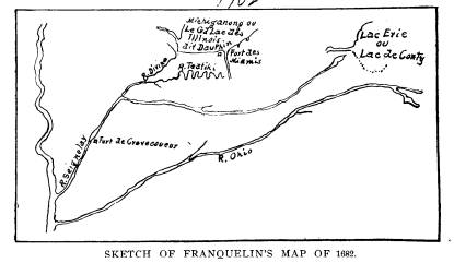
even through the first half of the 19th century, often partook of the nature of a lake, as shown on Franquelin's map herewith sketched. This swamp existed, until the last few years, a few miles southwest of the City of Fort Wayne, Indiana, it being the broad channel which first drained the Glacial Lake Maumee, and which has since been drained by the Aboite and Little River, the first northern tributary to the Wabash. Also it is significant |
|
|
|
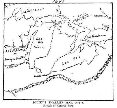
Anonymous. Sketch of Central Part. Figures refer to Legends that cannot be given here.
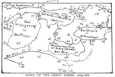
that none of the maps preceding this date, 1669, indicated the River Wabash nor the Ohio, though several do show the Mau- mee. In 1672, however, the Ohio appears on the map of The Basin of the Great Lakes, and Joliet's Smaller Map. Further, the stated latitude of thirty-seven degrees in the second extract accords well with the debouching of the Ohio River into the Mississippi. Fortunately we have corroborating evidence of the justness of the foregoing renderings of the befogged French by the writer. In Tract Number Twenty-five of the Western Reserve Historical Society, Mr. C. C. Baldwin then its Secretary, wrote as follows: |
|
Sieur de la Salle. 111
Mr. Margry, in a letter addressed to Col. Whittlesey, President of the Historical Society, after expressing in the kindest manner his thanks for the influence exerted here in behalf of his project [the publication of his researches], communicates the following extract of an unpublished letter of La Salle, (no date) which translated reads: The river which you see marked on my map of the southern coast of this lake [Erie] and towards the extremity called by the Iroquois Tiotontaenon, is without |
|
|
|
doubt the passage into the Ohio, or Olighira Sipon as it is called in Iroquois, or in Ottawa The Beautiful River. The distance from the one to the other is considerable, and the communication more difficult; but within a day's journey from its mouth at Lake Erie (washing as it flows a beautiful country) and at a musket shot from its banks, there is a little lake [the marsh southwest of Fort Wayne? See Map No. 1] from which flows a stream three or four fathoms wide at the outlet from the lake one fathom in depth. It soon changes, however, into a river by the junction of a number of other streams, which after a course of a hundred leagues, without rapids, [without great fall] receives another |
|
112 Ohio Arch. and His. Society Publications.
small river that comes from near the Miamis, and five or six others quite as large, and flowing with greater rapidity along the declivity of a mountain [higher ground] and discharging into the Illinois [Ohio] two |
|
|
|
leagues below a village and from there thence into the River Colbert. It is called the Quabachi or Aramoum. The original of this letter was sent to Mr. Parkman, who kindly returned it with the following note:
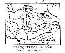
JAMAICA PLAINS, MASS., 9 Sept., 1872. DEAR SIR: With regard to the extract from La Salle's letter, one or two points are worth attention. It looks like an account made from hearsay. On the map described on pp. 406-7 of Discovery of the Great West, [map No. 2 above] the Maumee River is clearly laid down, with a portage direct to the Ohio, which is brought close to Lake Erie. This map is clearly anterior to 1680. On the map of Franquelin, 1864, made after data furnished by La Salle, the Maumee is also laid down, with a branch [tributary] to the Wabash, designated as R. Agonasake, closely approaching it. Now I have little doubt that 'la riviere que vous avez vue marquee dans ma carte,' is the Maumee, the natural route 'pour aller a la riviere Ohio ou Oleghin (Allegheny) Sipon.' The distance to the portage at Fort Wayne is certainly far more than 'une journee,' but accuracy is scarcely to be ex- pected. After crossing the protage, La Salle speaks of a stream 'qui se change bientot en riviere par la jonction de quantite de semblabies (et) qui apres le cours de plus de 100 lieues sans rapides recoit une autre petite riviere qui vient de proche celle des Miamis.' Such a 'petite riviere' is laid down on Franquelin's map. It flows into the Wabash, and answers to the Tippecanoe. The 'riviere des Miamis, an Franquelin's and other contemporary maps, is the St. Joseph of Lake Michigan. La Salle goes on to say that the main river in question, called by him 'Ouabache or Aramoni,' 'constant le long au penchant d' une montagne, se descharger dans celle des Illinois deux lieues an dessous du village et de la dans le fleuve Colbert' [Mississippi]. He begins by professing to indicate the way to the Ohio, but ends with bringing the traveler not to the Ohio but to the Illinois. I can see no other explanation of the passage, than that of a slip of the pen on La Salle's part, (or that of some copyist,) writing Illinois for Ohio. [See map No. 1, above.] I can think of no other way of making the passage intelligible. This solution derives some support from the circumstance that on Franquelin's map an Aborigine village Taarsila, is laid down a little above the mouth of the Wabash (Ouabache). La |
Sieur de la Salle. 113
Salle, you remember, says
that the mouth of this river is two
leagues below the
village.
The river is called
by him 'Aramoni ou Ouabache.' He speaks
a few years
later of another Aramoni,
identical with the Big Vermillion a
branch [tributary]
of the Illinois. One
of the branches [tributaries] of the Wabash
is also now called
Big Vermillion, and the
name Vermillion is given to the county
of Indiana where
this branch [tributary]
joins the main stream. The coincidence
is worth remarking.
Vermillion is mentioned
in La Salle's time as among the
chief articles of Aborigine
trade, and possibly Aramoni
may be the Illinois or Miami name
for it.
Yours very truly,
F. PARKMAN.
Summing up the question, it is presumed
by the writer that
La Salle's route to the Ohio River was
along the south shore of
Lake Erie, thence up the Maumee to its
source, thence to and
down the Little River to the Wabash.
After being forsaken by
his company, he turned his attention
more to the Aborigines,
first for the supply of his immediate
wants and, secondly, for
the investigation of trade
possibilities. While returning up the
Wabash and down the Maumee in the winter
and spring of
1669-70, he undoubtedly met many Miami
Aborigines from whom
he may have learned not only of the
River St. Joseph of Lake
Michigan, which he afterwards called the
Riviere des Miamis,
but of the Kankakee, Desplaines, and
Illinois Rivers, which he
explored ten years later after, and
with, great difficulties, but
intent upon determining the outlet of
the Great River - the Mis-
sissippi - and the best route to it. He
visited and associated
with many tribes of Aborigines, and
formulated broad plans of
trade with them from his observations
and experiences. Accord-
ing to the writing of Nicolas Perrot,
the author voyager, La
Salle explored the Ottawa River of
Canada in the summer of
1670 with a party of Iroquois.
Could La Salle have accomplished his
ambitions and his
plans, he would have led not only the
van of discoverers at all
times, but he would have controlled the
fur trade of the Great
Lakes, and of the rivers of the
Mississippi Basin. But those
high in authority, as well as the petty
dealers, were jealous,
watchful and hampering- while the quiet
plottings of assassins
ended his career in the year 1687 at the
age of forty-four years.
SIEUR DE LA SALLE,
The Great French Explorer, Along the
Maumee and Wabash
Rivers in the years 1669 and 1670.
BY CHARLES E. SLOCUM, M. D., PH. D.,
DEFIANCE, OHIO.
M. Jean Talon, Intendant of New France,
wrote to Louis
XIV king of France under date of loth
October, 1670, that he
had "dispatched persons of
resolution, who promise to penetrate
further than has ever been done; the one
to the West and to the
Northwest of Canada, and the others to
the South West and
South." (Paris Document I,
New York Colonial Documents,
vol. ix, page 64.)
Rene-Robert Cavelier, Sieur de la Salle,
being thus author-
itatively "dispatched", with a
party of twenty-four people started
from La Chine, just above Montreal, on
their journey to the south-
west 6th July, 1669, and, the 30th
September, separated from the
party that was going to the Northwest,
near the head of Lake
Ontario; after which, for a period of
toward two years, the
journeyings of La Salle, although much
discussed by learned
researchers, have not been fully
described, nor understood.
La Salle's maps and papers, supposedly
descriptive of these
journeyings, were reported by his aged
niece to have been in
existence as late as the year 1750; but
they have not been found
by his reviewers. In 1674 he returned to
France, and while
there had "ten or twelve
conversations" with a friend who soon
thereafter wrote, anonymously, a
"Histoire de Monsieur de la
Salle," which is reproduced by
Pierre Margry in the first volume,
page 376, of his Decouvertes, and
from which the following
extract is taken, viz:-
Cependant M. de la Salle continua son
chemin par une riviere.
qui va de l'est a l'ouest; et passe a
Ononataque, puis a six ou sept
lieues au-dessous du Lac Erie; et estant
parvenu jusqu'au 280me ou 83me
degre de longitude, et jusqu'au 41me
degre de latitude, trouva un sault
qui tombe vers l'ouest dans un pays bas,
marescageux, tout couvert de
vielles souches, dont il y en a
quelques-unes qui sont encore sur pied-
1 Vol. XII-2 (107)
(614) 297-2300