Ohio History Journal
- 1
- 2
- 3
- 4
- 5
- 6
- 7
- 8
- 9
- 10
- 11
- 12
- 13
- 14
- 15
- 16
- 17
- 18
- 19
- 20
- 21
- 22
- 23
- 24
- 25
- 26
- 27
- 28
- 29
- 30
- 31
- 32
- 33
- 34
- 35
- 36
- 37
- 38
- 39
- 40
- 41
- 42
- 43
- 44
- 45
- 46
- 47
- 48
- 49
- 50
- 51
- 52
- 53
- 54
- 55
- 56
- 57
- 58
- 59
- 60
- 61
EXPLORATIONS OF THE
GARTNER MOUND AND
VILLAGE SITE.
WM. C. MILLS, CURATOR OF THE STATE ARCH.
AND HIST. SOCIETY.
The Gartner mound, located partly upon
the land of Mr.
Adam Gartner and partly upon that of
Miss Elizabeth Lievy,
is situated about six miles north of
Chillicothe, on the east side
of the Scioto river. The river bank, at
this point, is quite high,
upward of 70 feet above low water mark,
and is very irregular,
with here and there spurs running up to
the river, which in
several instances are almost
perpendicular. The mound in ques-
tion is located upon one of these spurs.
However, this particular
spur is quite large and the banks are
not quite so abrupt as in
other places along the river. The north
side of the mound, or
the part situated upon the land of Miss
Lievy and which con-
stitutes about one-third of the mound,
had never been disturbed
by the plow and was covered with a dense
tangle of grape vines
and small trees; while the other
two-thirds upon the land of
Mr. Adam Gartner had been under
cultivation for a number
of years, consequently that portion had
been lowered about ten
inches. The mound at the time work began
was 7 feet 6 inches
in height, having a diameter of 75 feet.
Surrounding the mound
is the prehistoric village site similar
to the Baum village site,
which surrounds a large truncated
mound*. Around the mound,
upon all sides, particularly to the
south, are traces of former
Indian occupation. Numerous fragments of
pottery, similar in
texture and ornamental feature to those
found in the mound,
bestrew the ground. Intermingled with
these were the valves of
mussel shells, arrow-heads, pitted
stones, implements and orna-
ments made of bone, stone, and shell and
the bones of various
wild animals, which were used for food.
*The village site is situated along
Paint Creek a few miles south-
west of the small village of
Bourneville, Ross County, Ohio. A prelimin-
ary account is given in Vol. X. page 78,
of the Society's publications.
Vol.XIII-9. (129)
|
130 Ohio Arch. and Hist. Society Publications.
The soil from which the mound was made had evidently been collected from the village site and from the subterranean storehouses as they were dug from time to time as evidenced by thin layers of fine gravel and sand placed over a number of the burials which had been procured from the bottom of these pits. But, in every portion of the mound, various implements and ornaments were found intermingled with the soil and gravel. Here also were found animal bones and mussel shells which had evidently been gathered up with the soil from the village, as each successive burial was added to the mound. The mound was made up of three separate and distinct sec- tions as is shown in Fig. 1. The burials in the first section differed greatly from those in the second and third, which were similar. In the first section the bodies had been cremated and |
|
|
|
the ashes with the personal belongings had been deposited upon a prepared platform of earth; while in the second and third sec- tions the inhumation of the bodies were in every portion of the mound as well as below the base. Section No. 1, which is to the north, covers the site of an aboriginal domicile and was begun by carrying earth over an area 34 feet east and west, and 23 feet north and south to a depth of six inches. Over the top of this was placed tamped clay, which had evidently been secured while digging the subterranean pits used for the storage of corn, beans, etc., and which occur in every portion of the village. This clay had no doubt been puddled and then placed in position and made as level as a floor and this served as a platform to re- ceive the ashes of the cremated dead, which ashes irregularly covered the platform to a depth of from six inches to two and one-half feet. With the ashes were unburned animal bones, which had been intermingled with the incinerated human bones as well as implements and ornaments made of bone, stone and shell |
|
Explorations of the Gartner Mound and Village Site. 131 |
|
|

132 Ohio Arch. and Hist.
Society Publications.
which were no doubt the personal
property of the deceased. The
animals identified as they were removed
from these ashes were
the black bear, beaver, deer, elk,
raccoon, wolf, gray fox, musk
rat, ground hog, opossum and mink. The
bones of various birds
such as the wild turkey, great horned
owl, trumpeter swan and
wild goose, were also found. Quantities
of mussel shells, as
well as the bones of the fresh water
drum, were also removed.
Of the implements, the awl, made from
the tarsometatarsus of
the wild turkey, was perhaps the most
frequently met with.
These awls were found in every portion
of the ashes and in fact
every stage in the manufacture of this
most useful implement
was procured. Scrapers, made of the
metapodal bones of the
deer and elk were also removed in a
perfect state from the
ashes. However, the broken halves of
these scrapers were very
abundant in other portions of the mound,
but only a few were
taken from the ashes on the
platform. Perfect fish hooks made of
bone, as well as those in various stages
of the manufacture of this
implement were found intermingled with
the ashes. Shell disks
or gorgets, varying in diameter from one
to two inches, were
frequently found. These were made of
shell both foreign and
of the common fresh-water mussel shells
from the river. They
are circular in form, having two small
perforations near the edge
for attachment and a much larger
perforation near the center,
which was, no doubt, set with pearls as
we were able to find in a
grave in section 3 of the mound, a small
shell gorget set with a
fresh-water pearl.
The mound was entirely removed from the
platform pre-
viously described and its extent fully
known before examination
was made of the soil beneath. Fig. 2 shows a
photograph of the
platform. Beneath the platform, as is
shown in Fig. 1, were
found the remains of the refuse pits,
fireplaces, and even the post
molds of their little tepees were
visible. The pits, also the imple-
ments and ornaments taken from them,
were similar in every re-
spect to those found in the village
surrounding the mound as well
as those found in the Paint Creek
valley. No burials, other than
those of the cremated, were placed
directly upon the platform,
and a thorough examination of the ground
beneath revealed no
burials there, but 3� feet above the
surface of the platform were
|
Explorations of the Gartner Mound and Village Site. 133 |
|
|

134 Ohio Arch. and Hist.
Society Publications.
three burials which had been placed
there before the second section
found, was begun. In the second section
the burials were placed
below the base line as well as above it,
but none were found di-
rectly on the base line. An interesting
feature of several of the
burials was the finding of clay mixed
with broken quartz pebbles
and broken shell ready to be made into
pottery placed in a nitch in
the grave near the head. Fig. 3 shows
one of these graves. In
several instances this prepared clay was
accompanied by a
large mussel shell and perhaps a
well-wrought awl; in other
instances this clay was surrounded with
small river boulders
varying in diameter from two to three
inches. The small boul-
ders were usually piled in the form of a
pyramid over the top
of this clay. In one instance sixty of
them were removed. The
burials that were placed above the base
line were usually about
31/2 feet above the base. The burials in
the third section were
mostly below the base line and consisted
for the most part of
adults, resembling both in stature and
mode of burial those of
the first and second sections. However,
one skeleton measured
5 feet 103/4 inches in height, the
largest taken from the mound;
the average height of adults taken
from this mound being
5 feet 73/4 inches. The third section excelled in the number
and quality of the ornaments and
implements placed with the
dead. One grave contained a necklace
made of 27 perforated
canine teeth of the gray wolf and
mountain lion; another a shell
gorget set with a large fresh-water
pearl; another an earthen
jar which was removed in a perfect
condition, the only whole
piece of pottery taken from an Ohio
mound in a number of
years; from another a number of
perforated and worked wild
turkey's heads, each containing from
three to five small quartz
pebbles. The heads were attached to the
leg just below the
knee and perhaps served as an ornamental
rattle. During the
explorations at the Baum Village along
Paint Creek, these per-
forated heads of the wild turkey, as
well as several specimens of
wild duck, were found in goodly numbers
and caused much
speculation as to their use. However,
the find in this mound
has practically solved the problem.
The examination of this mound has been
of two-fold inter-
est: First, the village existed before
the mound was built, as
evidenced by the existence of the
remains of a domicile beneath
136
Ohio Arch. and Hist. Society Publications.
the platform, which was the first
portion of the mound that was
built and which was used as a depository
for the ashes of the
dead; second, that cremation of the dead
was practiced for a
long period as shown by the great
accumulation of incinerated
human bones.piled upon this platform,
which was 23 feet wide
by 34 feet long to the height of 21/2
feet at the center. Further
proof of this method of disposing of the
dead was furnished by
finding the crematory in which the
bodies were prepared for the
last sad rites. This crematory was 16
feet wide and more than
twice that in length and contained the
half-charred remains of a
human body surrounded with charcoal and
ashes, showing that
the work of cremation had been brought
suddenly to a close and
the crematory with its half-burned human
skeleton was covered
with earth, and a mound heaped over the
ashes upon the platform,
blotting out all traces of the practice
of cremating the dead, and
inhumation in the regular way followed.
The question naturally
arises, What caused this sudden change
in the mode of disposing
of the dead? The answer can only be
conjecture. It occurred
to me that perhaps the first occupants
of the village were driven
away by an enemy and the newcomers had
different rites and
ceremonies in disposing of their dead.
But a comparison of the
artifacts taken from the refuse pits
beneath the platform and
from the ashes upon the platform, with
those taken from the
other sections of the mound shows
definitely, that they are simi-
lar both in design and workmanship.
Consequently, this cannot
be assigned a reason for the sudden
change in the manner of
disposing of the dead. However, I am
inclined to believe, from
the evidence obtained by the
explorations, that the inhabitants
suddenly left their village either
voluntarily or were driven away
by an enemy and sojourned for a time
with a tribe having a
different mode of disposing of their
dead and upon their return
they continued the practice of their
neighbors.
DETAILED ACCOUNT OF THE MOUND
EXPLORATION.
The work of examining this mound was
begun at the base
line on the east side and carried
forward due west until the
large platform was found and partly
uncovered, then the exami-
nation continued from the north and west
in order to uncover the
platform so its extent might be fully
ascertained. The portion
Explorations of the Gartner Mound and
Village Site. 137
of the mound located upon the land of
Miss Lievy was covered
near the base, with a leaf mold from
seven to ten inches thick.
Beneath the leaf mold was a dark earth
filled with animal bones,
such as the deer, which constituted 75%
of all the bones, the
raccoon, gray fox, mountain lion, wild
cat, beaver, musk rat,
opossum, squirrel and Indian dog. Bones
of the wild turkey
were quite abundant, yet the bones of
the wild goose and great
horned owl were also mingled with the
black soil. This dark
earth was also rich in implements such
as bone awls, scrapers,
celts, flint arrow-points, as well as
ornaments made of bone and
shell. At the very edge of the mound was
found the skeleton
of an adult lying upon the right side
with the head bent forward
and the legs flexed so that the knees
were in close proximity to
the head. The body had been placed upon
the base of the mound
and was covered with less than one foot
of earth. However, it
could not be considered an intrusive
burial, as the small layer of
gravel which covered the mound about six
inches above the
burial had not been disturbed. No
implements or ornaments of
any kind were placed with this burial.
It was found in section 2.
Skeleton No. 2 was that of a child about
one year old. It
was placed directly to the east of the
center and on the base
line.
Skeleton No. 3 was that of an adult and
was placed 21/2
feet above the base line. The mound at
this point was five feet
high.
This skeleton was found in section 3 of the mound.
Skeleton No. 4 was placed in close
proximity to skeleton 2 in
section 2, but was placed in a grave two
feet below the base line.
It was that of an adult male. In a nitch
near the head of the
skeleton were found a large number of
round boulders varying
in diameter from two to three inches.
These were placed in a
pile in regular order around a mass of
clay which had been mixed
with broken quartz and this clay was, no
doubt, intended to be
made into pottery. Near the pile of
boulders was also placed
several valves of mussel shells and a
well-wrought awl six inches
in length. At the back of the head was
placed a fine discoidal
stone made of granite porphyry 33/4
inches in diameter and 2
inches thick, each side hollowed out and
pierced with a hole
one-half inch in diameter at the center.
The outer edges are
convex. The whole specimen is highly
polished with the ex-
|
138 Ohio Arch. and Hist. Society Publications.
ception of the concave sides, which seem to have been freshly pecked. This is readily seen on both sides of the stone. See Fig 4. At the right side was placed a large stone implement, perhaps a war club, made of limestone. It is 21/2 feet long, 3 inches wide and 2 inches thick. The stone is smaller at one end and the edge has been rounded and has the appearance of being water worn with the exception of a few places which show the hand work of man. Fig. 5 shows the skeleton with the discoidal at the rear of the head and the war club lying on the right side of the head. From around the neck of the skeleton was removed |
|
|
|
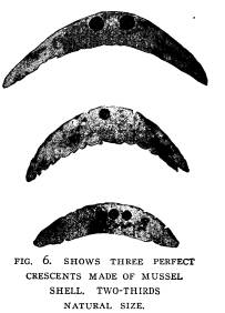
three perfect crescents made of mussel shells; these are shown in Fig. 6. The largest one, which is pierced with two holes, is 21/2 inches in length and is not decorated. The second crescent, which was hung directly below the first, is two inches in length and pierced with one hole, but is decorated with notched edges. The third crescent, which is 1 1-3 inches in length, is pierced with three holes and the edges are also ornamented with notches. Attached to these crescents below were found three triangular pieces of ocean shell perforated for attachment and four beads made of small ocean shells. |
|
Explorations of the Gartner Mound and Village Site. 139
Skeleton No. 5 was an adult and was buried in section 2. It was placed three feet below the base line. Around the neck was a crescent two inches in length and pierced with two holes and ornamented with notched edges. The crescent was similar in every respect to those found with skeleton No. 4, differing only in the material from which it is made. Those in No. 4 were made from common fresh-water mussel shells from the river, while the one from No. 5 was made from the body whorl of an ocean shell. Near the left hand were two small arrow-points |
|
|
|
both showing that they were made by a skilled artisan, one being of the triangular form 1� inches in length and the other having a notched base and being 13/4 inches in length. Skeleton No. 6 was buried three feet below the base line. With it was found puddled and tempered clay ready to be made into pottery. This clay was placed in a nitch in the grave near the head of the skeleton and with it were two large mussel shells, a few broken bones of the deer, and the humerus of the wild turkey. |
|
140 Ohio Arch. and Hist. Society Publications. |
|
|

|
Skeleton No. 7 was buried 31/2 feet above the base line and was that of an adult. Near the head was placed a fine large awl, 8 inches in length. This awl was deco- rated with incised lines entirely encircling the awl near the point, and about two inches from the point was an enlargement in the body of the awl. This mode of orna- mentation seems to be the usual method of decorating the large awls. Skeleton No. 8 was that of an adult and was placed four feet below the base line. A large awl was found at the head, this was 8� inches in length and made of |
|
bones, one end of which was ornamented with a carved head represent- ing that of a fox. This is shown in Fig. 7. On the right side of the grave near the head was a quantity of clay mixed with broken shells and a few small boulders placed around it similar to skeleton No. 6. Skeleton No. 9 was an adult male buried four feet above the base line. The skele- ton was in a good state |
|
|
|
of preservation. Near the left hand were several small arrow-heads of the triangular type, beautifully chipped and made from flint ridge chalcedony. Skeleton No. 10 was that of an adult placed 41/2 feet above the base line. This was the only skeleton in the |
|
mound that I considered an intrusive burial. The grave shows that it was dug through the regular strata of earth, sand and gravel, that was used in the construction of this portion of the |
|
Explorations of the Gartner Mound and Village Site. 141
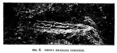
mound. With this burial was a small arrow-point and a few cut bear teeth, placed near the head. Skeletons Nos. 11, 12, 13, and 14 were all adult burials placed above the base line about 31/2 feet. No implements or or- naments of any kind were placed with these burials. Skeleton No. 15 was an adult male, placed in section 2, four feet above the base line. The skeleton was headless, as shown in Fig. 8. However, a number of fine bone beads were taken from near the left shoulder. Upon the right arm were a number of well-wrought beads made of shell, one-fourth inch in diameter. Near the foot was placed two fine arrow-points made of chal- cedony. |
|
|
|
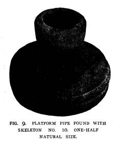
Skeletons 16 and 17 were in section 3; both were adults and placed three feet below the surface. No implements or ornaments were placed with them. Skeleton 18 was that of an adult male, placed in section 2 and was buried five feet below the base line. Upon the right arm were a number of beads made of ocean shell and near the head was placed a platform pipe; around the neck was a neck- lace of beads. The platform pipe is far different from any of the pipes found in this section. It is made of a reddish brown com- pact sandstone with a circular base 23/8 inches in diameter, and 3/4 inch in thickness. The bowl extends from the center of this cir- cular base and is 11/8 inches in height and 7/8 of an inch in diameter at the base of the bowl, gradually tapering to 13/8 inch at the top. The diameter of the hole in the bowl is 3/4 inch, which gradually |
|
142 Ohio Arch. and Hist. Society Publications.
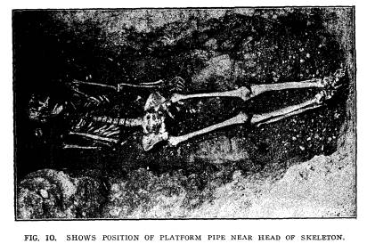
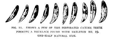
tapers to the bottom and is connected with a hole from the plat- form, which is 1/2 inch in diameter at the edge of the base and gradually tapers, similar to that of the bowl. The platform is ornamented with three deep cut lines which encircle the outer edge. The bottom of the base is marked with incised lines. The pipe is shown in Fig. 9. The grave showing the skeleton and pipe is shown in Fig. 10. Skeleton 19 was that of a child about ten years of age. The burial was upon the base line of section 3 and the skeleton was fairly well preserved. Around the neck was placed a necklace consisting of 46 canine teeth about equally divided between those of the dog, raccoon, and wild cat. Fig. 11 shows a few of the teeth. |
|
|
Skeleton 20 was that of an adult female and was buried 21/2 feet above the base line in section 3. It was in a good state of preservation. The skull on the left side near the top was crushed in such a manner as to form al- most a circular hole 11/2 inches in diameter and had the appearance of having been made with some blunt instrument and no doubt caused the death of the in- dividual. Around the neck were a few bone beads made from the wing bones of the wild turkey. |
|
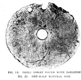
Work was now commenced on the west side of the mound in order to aid the workmen in carefully uncovering the skele- tons so that photographs could be made. No burials were found near the western edge of the mound, but as the center was ap- proached, skeleton 21, that of an adult male, was found three feet above the base line. Near the head and at the back was removed a large ocean shell gorget 4 inches in diameter and |
|
Explorations of the Gartner Mound and Village Site. 143
made from the body whorl of the massive conch (Fulgur per- versum). The gorget was pierced at the center with a hole 1/2 inch in diameter and near the edge two small holes were |
|
|
|
placed for attachment. The gorget was not in a good state of preservation, as the portion containing the perforations was near the head and was very brittle, consequently it crumbled slightly in removing it from the burial. Fig. 12 shows a photo- |
|
|
|
graph of the gorget. Directly beneath this gorget was a large bone awl 6 inches in length and made of one of the heavy bones of the deer or elk. At the side of the gorget was another awl |
|
144 Ohio Arch. and Hist. Society Publications.
of about the same size and shape. The skeleton was well pre- served. Skeleton 22 was that of an adult male placed three feet above the base line and partly over the platform which covers the base of section 1. This skeleton was in close proximity to skeleton 21. Two shell beads 1/2 inch in diameter were found near the left hand. Skeleton 23 was that of an adult male placed three feet above the platform, and was in a good state of preservation. No implements or ornaments were placed in the grave. |
|
|
|
Skeleton 24 was an adult male placed in section 3. It was buried in a grave four feet below the base line. With the skele- ton were two perfor- ated canine teeth of the elk, which are ex- ceedingly rare in the graves of this mound. Skeleton 25 was an adult male buried four feet below the base line in section 3. One large spear-point was placed upon the right |
|
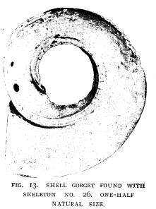
side near the hand. The point was 4 inches in length and made of reddish brown flint. Skeleton 26 was that of a child and was placed in section 2. It was buried 31/2 feet above the base line. Around the lower legs were placed small ocean shell beads, varying in diameter from 1/4 to 3/8 of an inch and about 1/8 of an inch in thickness. All were finely wrought and well polished. Upwards of 700 beads were removed from this grave. On the breast was found a large ocean shell gorget, 4 inches in diameter, made from the apex portion of the massive conch (Fulgur perversum). Near one |
|
Explorations of the Gartner Mound and Village Site. 145
edge it is pierced with two holes for attachment, the central por- tion having been removed. This gorget is shown in Fig. 13. Skeleton 27 is that of an adult found in section 2. It was placed two feet above the base line. No implements or ornaments were placed with this skeleton. Skeletons 28, 29, 30, and 31 were all placed in graves be- low the base of the mound in section 3. The graves ranged in depth from 2 to 3 feet. No implements were placed with these skeletons. Skeleton 32 was placed near the west side of section 3 and |
|
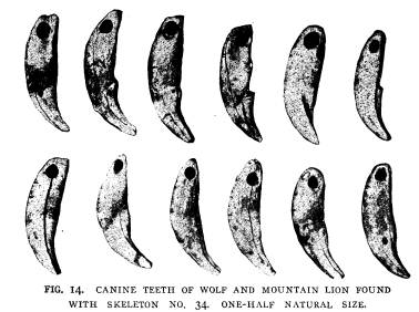
was two feet below the sur- face. It was that of an adult male. At the head were placed two large bone awls 6 and 63/4 inches re- spectively in length. These were placed directly under the head and were badly de- caved. Skeleton 34 was that of an adult male and was buried two feet below the base line. From around the neck was removed a necklace made from 27 canine teeth, 19 of which were those of the gray wolf and 8 of the mountain lion. Each tooth was pierced with a hole near the end of |
|
|
|
the root, for attachment. Each tooth was ornamented by hav- ing from 3 to 4 deep lines cut across the concave surface. A representative collection of these teeth is shown in Fig. 14. At the side of the head were placed two badly decayed bone awls 5 and 51/2 inches in length, respectively. Near the arm a number of shell beads were found; these were made from small ocean shells.
Vol. XIII--10. |
|
146 Ohio Arch. and Hist. Society Publications.
Skeleton 35 was placed very near 34 and at about the same depth below the base line. Around the neck were a number of cut pieces of ocean shell, made from the body whorl. These were triangular in form. With these were a number of small ocean shells. Skeletons 36 and 37 were also placed below the base. No im- plements or ornaments were placed with them. Skeleton 38 was buried three feet below the base line. The skeleton was placed on the right side, facing the east. Near the |
|
|
|
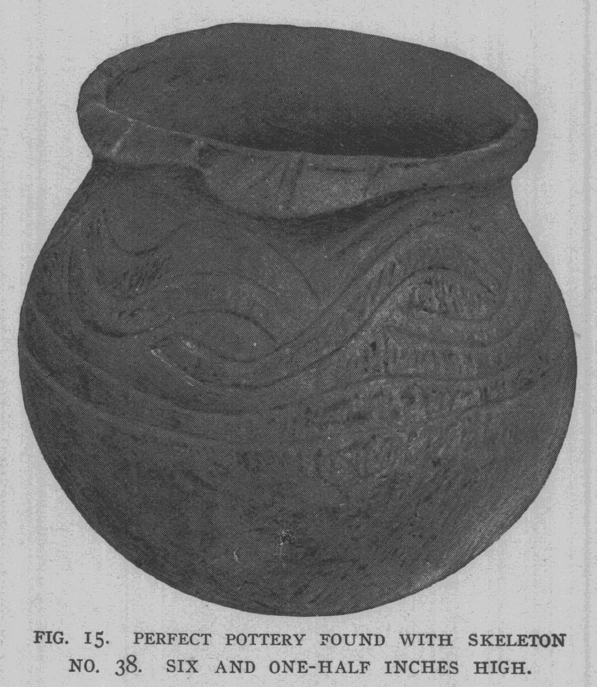
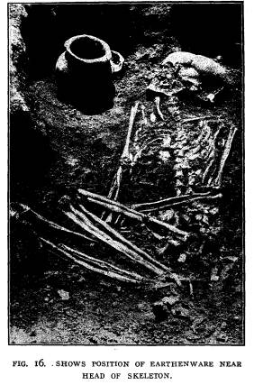
head was found a perfect piece of pottery, 6� inches high and 7 inches in diameter at the largest part of the bowl. The opening on top is 41/2 inches in diameter. The top portion of the bowl is decorated with incised lines made in the form of a scroll which entirely encircles the vessel. Directly beneath the scroll work are two incised lines running entirely around the vessel. The lower part shows the impression of the cloth used in the hands while being fashioned. Fig. 15 shows this vessel. At the side of the vessel was a spoon made of mussel shell. Fig. 16 shows the skeleton and vessel before they were removed from the grave. |
|
Explorations of the Gartner Mound and Village Site. 147
Skeleton 39 was that of an adult female and was buried three feet below the base line in section 3. Around the right leg below the knee were found 14 wild turkey heads pierced with holes for attachment. Inside the heads were found small quartz pebbles, showing that they had been used for rattles. Upon the left leg at about the same place was a turtle back. This was also per- forated for attachment and contained 15 small quartz pebbles. Upon the breast was found a small gorget pierced with two holes near the edge and one in the center. This gorget is 1� inches in |
|
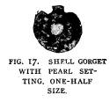
diameter and made of mussel shell. Skeleton 40 is that of an adult female. Around the neck were a number of shell gorgets similar to the gorgets found with skeleton 39. One of these, however, had a pearl setting in the large central hole. The gorget with pearl setting is shown in Fig. 17. Skeleton 4 and 42 were also |
|
|
|
adults and were placed below the base, but near the edge of the mound. No implements or ornaments of any kind were placed with these skeletons. |
|
148 Ohio Arch. and Hist. Society Publications. |
|
|

|
Explorations of the Gartner Mount and Village Site. 149
GARTNER VILLAGE SITE. The village site which surrounds the Gartner mound, just described, was ex- |
|
amined during the summer of 1903. Fig. 18 is a drawing of mound and vil- lage site, show- ing the extent of the field explora- tions during 1903. The village site proper, occupies between three and four acres of land and entirely sur- rounds the mound. How- ever, directly south and south- east of the mound, surface indications are richest; for here our examination showed the earth was intermingled with the refuse from their homes |
|
|
to the depth of from one foot to twenty inches, indicating that |
|
|
they occupied this place for a long period. Directly to the south and less than one-half mile is what is known as the Cedar Bank Works, which has been described by Squier and Davis on page 52, in "Ancient Monu- ments of the Mississippi Valley." We made a thorough search of this enclosure of 32 |
150
Ohio Arch. and Hist. Society Publications.
acre as well as the immediate
surrounding territory, in search
of a village, but found no evidences of
a former habitat other
than the Gartner village. Therefore, it
seems reasonable to be-
lieve that the inhabitants of the
Gartner village were the builders
of the Cedar Bank Works. However, no
explorations have been
made within the works to verify this
statement. Upon a spur
of the hill between this village and the
Cedar Bank Works are
also indications of a former habitat, as
flint implements, broken
pieces of pottery and animal bones of
various kinds are sparingly
scattered over the surface. As the
examination progressed it
was soon discovered that the inhabitants
of this village lived in
small clans or family groups. Although
only fifteen skeletons
were unearthed in the examination of
this village, there is no doubt
but that burials were made along the
hillside which surrounds
the village on three sides.
The refuse pits, which are so abundant
in the villages of the
Paint Creek valley, were present in
great numbers and distributed
over the village site surrounding the
habitats of the various fam-
ilies. Fig. No. 19 shows ten of these
pits open at one time.
During the examination in the village,
more than 100 pits were
found and thoroughly examined. The
evidence produced by this
examination shows that 20% of the pits
examined were originally
used for storehouses for grain, beans
and nuts, and perhaps for
animal food. These pits were lined with
straw or bark and in
some instances the ears of corn laid in
regular order upon the
bottom; in other instances the corn was
shelled and placed in
woven bags; in others shelled corn and
beans were found to-
gether; in others hickory nuts, walnuts,
chestnuts and seeds of
the pawpaw were present in goodly
numbers. All this was in the
charred state, accidently caused, no
doubt, by fire being blown
into these pits and the supplies
practically destroyed before the
flames were subdued. Fig. 20 shows charred
cobs and lumps
of charred shelled corn. The burning of
these supplies must have
been a great loss to these primitive
people and may have caused
them great suffering during the severe
winters, but it has left a
record of their industry which never
could have been ascertained
in any other way. The great number of
pits found, which show
conclusively by their charred remains
their early uses, would lead
|
Explorations of the Gartner Mound and Village Site. 151
one to believe that all the pits found were used originally for underground storehouses and by spring time, when the supplies were likely consumed, a general forced cleaning up of their domi- ciles and surroundings would occur and the empty storehouse would serve as a receptacle for this refuse, which was henceforth |
|
|

|
used for that purpose until completely filled. During the autumn, when the harvest time came, a new storehouse would be dug and the grain and nuts gathered and stored for winter use. The examination of the pits has brought out the above conclusions as evidenced by the refuse found therein. Near the bottom of the pits will invariably be found the heads of various animals such |
|
15 Ohio Arch. and Hist. Society Publications.
as the deer, with antlers attached, black bear, raccoon, gray fox, rabbit and the wild turkey, as well as the large, heavy broken bones of these animals such as would likely be found around a winter camp. Further, some of the large bones showed that they had been gnawed in such a manner as to indicate the presence of a domesticated dog, whose presence was further corroborated by |
|
|

|
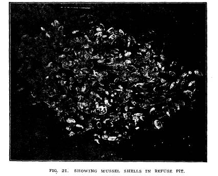
finding his remains in every part of the village. Therefore, taking all these facts into consideration, one must necessarily infer that the spring cleaning took place and animal bones, broken pottery and the general refuse was thrown into the pits. Further, the remains of fish are seldom ever found near the bottom of the pits, but usually occur from the top to about the middle. Mussel shells are never found at the bottom of the pits, but are usually |
|
Explorations of the Gartner Mount and Village Site. 153
found near the middle or half way between the middle and top of the pit. Fig. 21 shows how mussel shells are sometimes pres- ent in the refuse pits. We know that fish and mussels must be |
|
|
|
taken during the spring, summer and autumn and are certainly very hard to procure during the winter. A drawing representing a cross section of the village site showing the location of the |
|
|
|
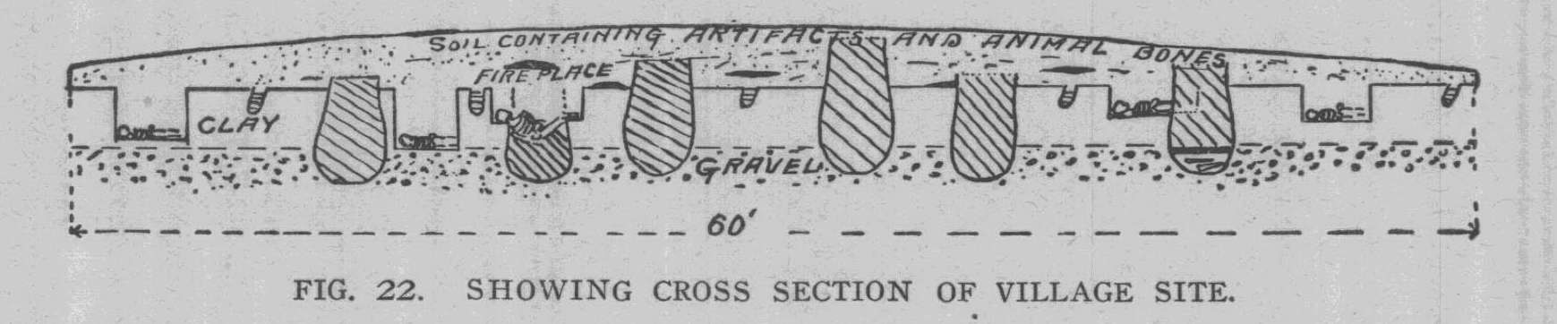
tepees, fireplaces, refuse pits and burials is shown in Fig. 22. This represents a cut of sixty feet which was carried forward in the examination of the village. This drawing shows the fireplaces |
154
Ohio Arch. and Hist. Society Publications.
to have been made at different periods
of time. Some of these
fireplaces are directly above the refuse
pits and it is also shown
that in digging the pits, that they dug
down upon previous burials,
but even this did not cause them to
abandon the pit, but to
remove the bones and dig on to the
necessary depth and place
the dislodged bones in the bottom of the
pit and cover them
slightly with soil. In some, the burial
was made directly over an
old pit and the refuse in the pit being
porous the body would
naturally sink into the pit, leaving the
legs and head higher than
the other portions of the body. The
accumulation of bones of
various animals and the implements and
ornaments of these primi-
tive people found through the soil was
caused by the covering up,
from time to time, of the debris in the
tepees and surroundings
which would naturally be greater during
the winter season.
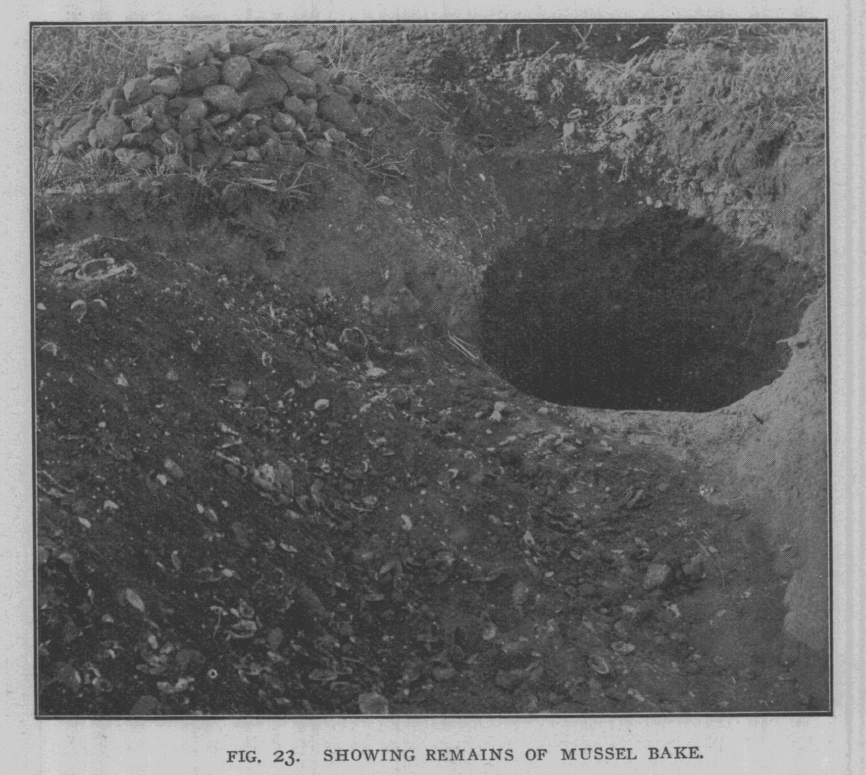
Another interesting feature of this
village was the finding
of the remains of two mussel bakes. One
only will be described,
as they were similar in every respect.
These bakes were made
by digging a hole in the ground 5 feet
deep and 4 feet in diameter.
A fire was built in the bottom of this
pit; so great was the fire
that the clay forming the sides of the
pit was burned to a deep
red and several inches in depth. Four
hundred and fifty small
river boulders varying in diameter from
3 to 1O inches were
thrown upon this fire and then the
fresh-water mussels of small
size were piled upon the stones and the
entire pit filled with these
mussels. The top was then, no doubt,
covered over with grass
and the mussels left to bake. After the
feast, for it was no doubt
a feast, the shells were thrown back
into the pit as well as into a
number of surrounding pits that were
open. We made a careful
estimate of the number of mussels
required in these mussel bakes
by counting the mussel shells in a given
space, and found that
more than 1O,OOO mussels were used in
the two bakes. They
were all of small size and in the two
bakes only a few large shells
were present. The mussels had, no doubt,
been procured from
the Scioto river, only one hundred yards
distant. Fig. 23 shows
one of these pits. In the rear is a pile
of charcoal taken from the
bottom of the pit, at the side are the
boulders. In one of the
refuse pits we found evidences of a
great animal feast, as the pit
was filled for several feet with a mass
of broken bones, showing
|
Explorations of the Gartner Mound and Village Site. 155
that they had used the deer, bear, elk, beaver, raccoon, opossum and wild turkey in this great feast. A number of individual ani- mals of each were used, but more especially the deer, as seven jaw bones of this animal were removed from this great pile. Another interesting feature of this village site was the find- ing of a great fireplace or crematory, over 40 feet in length and varying in width from 16 to 17 feet. It was directly south of |
|
|
|
the mound, not far from the edge of the bank, which gradually descends to the river below. The fire had evidently been kindled on this hearth for a long time, as the earth was burned to a depth of 14 inches. The crematory occupied a slight depression in the ground, no doubt caused by the careful removal of ashes from time to time. Not a particle of ashes, charcoal or burned bones was present in this fireplace except at the west end nearest |
156 Ohio Arch. and Hist. Society Publications.
to the river, where the portions of a
half-charred human skeleton
surrounded with charcoal and ashes were
found, showing that
the cremation had been brought to a
sudden close and the par-
tially incinerated skeleton, as well as
the crematory and its sur-
roundings, was covered with about 6
inches of earth as if to
remove from sight all traces of a once
practiced mortuary cus-
tom. Gradually, as our explorations
show, a little home was in-
stalled near the edge of the crematory,
to the north, and in due
time the site became covered with the
refuse which accumulates
about their domicile.
FOOD RESOURCES.
Animal Remains. -In
all, the remains of 17 different ani-
mals were procured in this village. The
most abundant was that
of the Virginia deer, which constituted
fully 50% of the animals
taken from the pits and which were used
for food. The other
animals identified were the raccoon,
rabbit, black bear, beaver,
gray fox, wild cat, mountain lion, gray
wolf, opossum, mink,
musk rat, elk, skunk, groundhog, otter,
and Indian dog. The
small box turtle (Cestudo virginia) was
in great abundance.
The wild turkey constituted fully
80% of the birds taken from
the refuse pits while the trumpeter
swan, wild goose, great
horned owl, bald eagle and bittern were
found in small numbers.
The Scioto River, near by, teaming with
fish and fresh water
mussels must have been an excellent
source of animal food as
shown by the presence of fishbone and
mussel shells. The Indian
dog found in this village resembles in
every respect the remains of
the Indian dog found at the Baum village
site, which is de-
scribed in Vol. X, page 81, of the
Society's publications.
Vegetable Food. - The vegetable substances usually found
in the bottom of the refuse pits and
which had been preserved by
being charred, consisted of corn, beans,
hickory nuts, walnuts,
butternuts, hazelnuts, and the seeds of
the wild plum and pawpaw.
Of this, the corn (Zea mays) was the
most abundant and was
always found in the bottom of refuse
pits that had, no doubt,
served as storehouses until destroyed by
fire. These pits were
usually lined with bark or straw and the
corn was frequently
scattered through the charred remains.
However, in a number
of instances the corn and beans had been
placed together in a
|
Explorations of the Gartner Mound and Village Site. 157 |
|
|

158 Ohio Arch. and Hist.
Society Publications.
heap and were removed in large lumps. In
a number of instances
corn and beans had been placed in
earthen vessels that had be-
come broken and the charred corn was
still clinging to the sides
of the vessel. Burned corn was also
found in a vessel that had
been broken, no doubt, by the action of
the fire, as the corn was
in a charred mass in the pieces of a
broken vessel which had been
scattered through the refuse pit,
showing that the burning of this
corn had taken place outside of this
pit. Beans (Phaseolus, sp,,)
were also found in quantities in the
bottom of the storehouses.
From the quantities of these two food
articles found, there is no
doubt but that corn and beans were a
staple article of food for
this primitive people. Hickorynuts were
very abundant; three
species were found, hicora minimia
(Marsh.) Britt., hicora
ovata (Mill.) Britt., and hicora
laciniosa (Mx.) Britt. Only
small quantities of butternuts (guglans
cinera, L,) and black
walnuts (juglans nigra, L.) were found.
In some places great
quantities of the charred pawpaw seed
(asiminan tribola, L,)
Dunal, were found, stored in connection
with corn and nuts. In
several other pits the wild hazelnut
(corylus Americana) Walt.,
and the wild red plum (prunis Americana)
Marsh., were present
in small quantities.
Preparation of Food. - In every portion of the village were
found stone pestles, which served for
crushing the corn and beans
and were, no doubt, also used in
crushing the dried meats, ber-
ries, etc. Many of these pestles are
merely natural pebbles slightly
changed by a little pecking or rubbing,
or perhaps both. Some
have been pecked into shape and resemble
a concoid body with
an enlarged and flattened base,
bell-shaped, and running to a point
at the top. None of the pestles are
ornamented, but are all quite
plain. Large stone mortars made from
slabs of sandstone, from
12 to 14 inches in length, from 10 to 12 inches in width,
and from
4 to 6 inches in thickness with a
depression on one side, several
inches in depth, were taken from the
pits. The mortar must have
been universally used in this village,
as great numbers of the
broken and perfect ones have been found
in the pits and tepee
sites. Another article that was, no
doubt, universally used in
the preparation of food is the pottery.
Broken pieces of this
domestic utensil are found everywhere in
the village and refuse
Explorations of the Gartner Mound and
Village Site. 159
pits. In many instances hundreds of
pieces were taken out of
one pit and they were universally
abundant around the fireplaces.
There is no doubt but that the potters'
art was practiced by each
clan or family in the village, for the
broken pieces of pots found
in these clans were similar in every
respect, but differing slightly
in ornamentation from those of the
neighboring clans. The earth
from which the pottery was made was
procured while excavating
for the large storehouses, as the clay
found in the pits, which had
been tempered with broken shells and
crushed quartzite, were
identical with the clay thrown from the
pits. The majority of
the pottery was made by crushing shells
and tempering the clay,
but now and then a piece would be found,
which had been tem-
pered with crushed quartzite and
pebbles. However, near the
west side of the village a small
quantity of the broken pottery
was made from clay tempered with broken
quartz. Only one per-
fect piece of pottery was found in the
mound and none in the
village site, except the small vessels
which had been molded in
the hand. Yet broken pieces, resembling
in every way, the perfect
pieces, were found in abundance in the
village. The size of the
pottery varied greatly, one piece
especially that was taken from
the refuse pits, if perfect, would
measure 141/2 inches in diameter,
while several very small pieces that had
been molded in the hand
were found in various sections of the
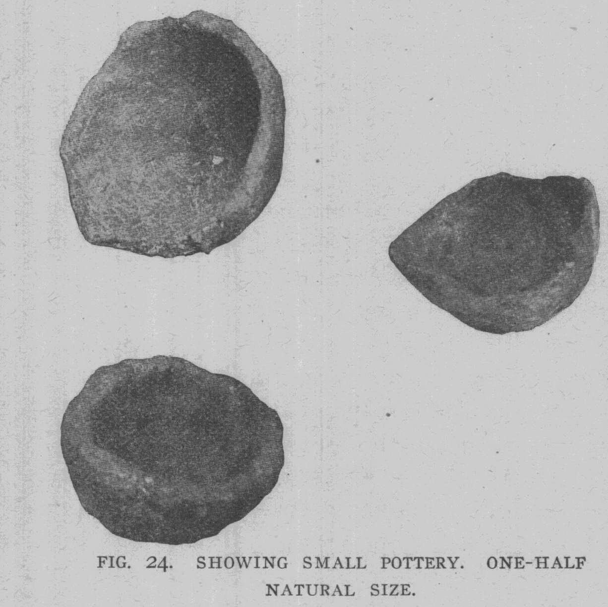
village. The small pieces
of pottery varied in size from that of a
thimble to a small cup 2
inches in diameter. These small vessels
were without ornamenta-
tion and were of common use, for a
number have been found,
both perfect and broken, in all sections
of the village. These are
shown in Fig. 24. The marks on the
pottery differ somewhat in
the different clans and practically all
of the pottery had textile
marks upon the side. In several
instances, impressions of a
woven fabric, which had, no doubt, been
used in the hands while
fashioning the plastic clay, were found.
In other instances the
marks of the textiles were evidently
made by modeling paddles
which had been wrapped with cord, as
this is plainly shown upon
the handles of the vessels as the handle
is usually fashioned and
put in place after the vessel is
practically tormed. A further orna-
mentation of a number of vessels is made
by incised lines. Some
of these encircle the vessel, while
others appear in scrolls; this
|
160 Ohio Arch. and Hist. Society Publications.
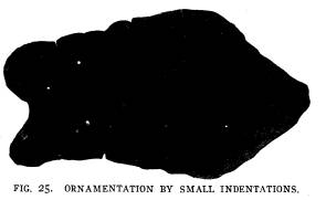
is shown in Fig. 15. Still other vessels are ornamented with small round indentations made by a blunt instrument, as is shown |
|
|
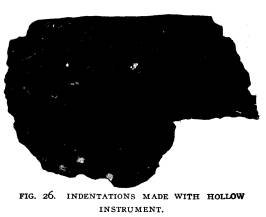
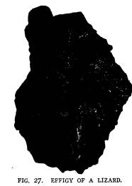
in Fig. 25. Other vessels show inden- tations made with a reed or some hol- low instrument; this is shown in Fig. 26. The abo- rigines of the Gart- ner village seem to have possessed the artistic faculties at- tributed to the early races in America, for rude forms of art in clay deco- rated their pottery as shown in Fig. 28. This effigy of a lizard was exe- |
|
cuted with considerable fidelity to nature and perhaps served as a handle as well as to ornament the vessel. However, the ma- jority of the pieces have plain tops ornamented now and then |
|
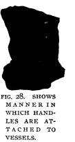
with indenta- tions. Practi- cally all of the larger vessels were supplied with handles which were in- variably orna- mented with in- cised lines and indentations. In size the handles |
|
|
were usually in proportion to the vessel. The larger handles were attached at one end by first piercing the vessel with a hole |
|
Explorations of the Gartner Mound and Village Site. 161
and inserting a small plug of clay which was carefully clinched upon the inside of the vessel. On the outside the handle was |
|
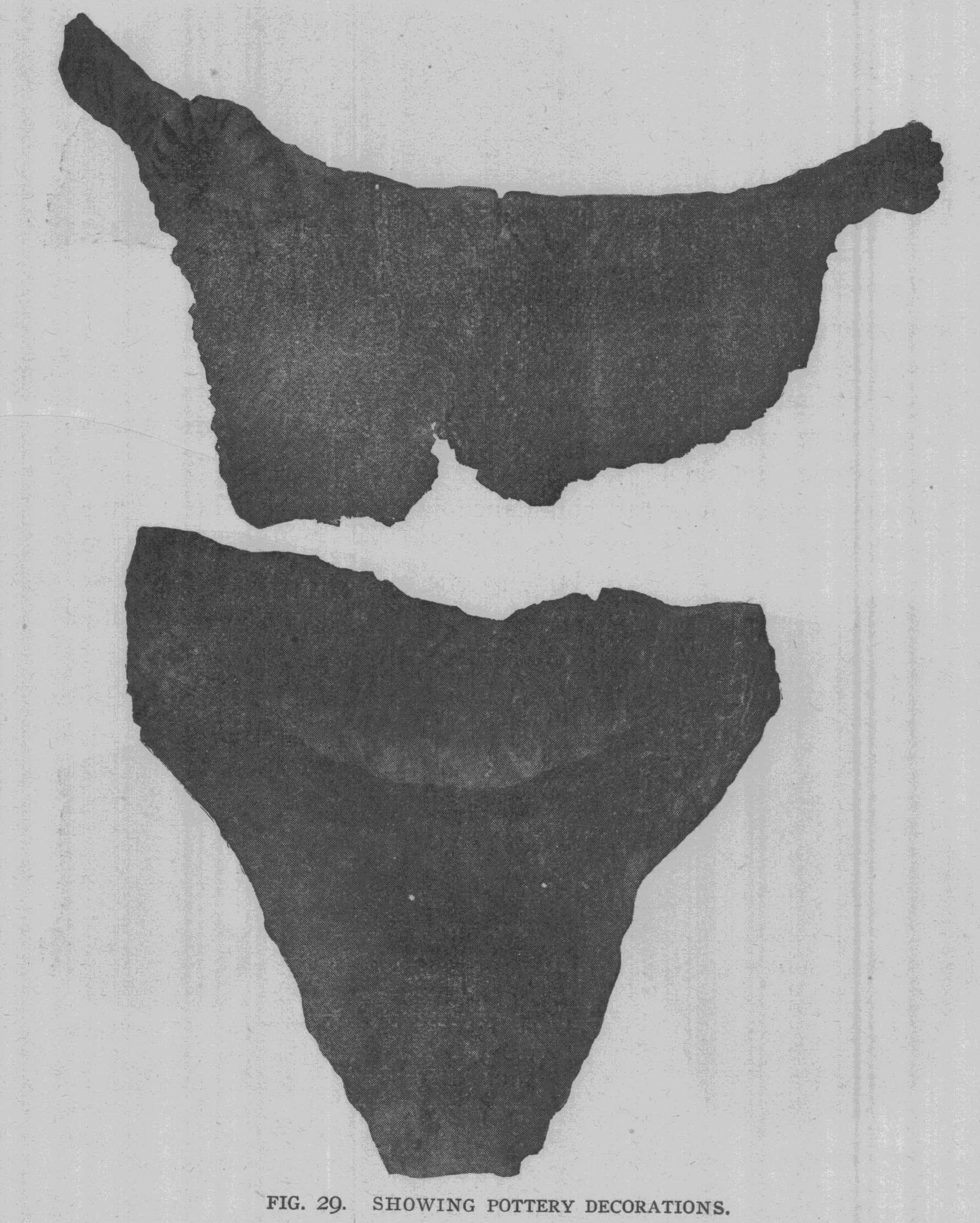
molded to this plug; this is shown in Fig. 28. In Fig. 29, sev- eral pieces of pottery are shown which rep- resent a few of the many examples of na- tive ceramic art. Implements. - The implements used for the procuring of food and for domestic pur- poses were made of bone, stone, and shell |
|
|
and are found in great abundance in the village site. These implements were in proportion of about ten of those made from |
|
|
bone to one made from shell or stone. In fact, many of stone were duplicated in bone or horn, such as scrapers, arrow-points, spear-points, and large |
|
celt-like forms made from elk horn. Stone Implements.- The chipped imple- ments were, no doubt, made from flint, pro- cured from the Flint Ridge locality. The chipped points for ar- rows were, for the most part, of the tri- angular form andplain- ly shows that the peo- |
|
|
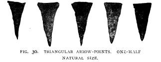
ple inhabiting this village were versed in the art of flint chip- ping. A typical series of these arrow-points is illustrated in Vol. XIII-- 11. |
|
162 Ohio Arch. and Hist. Society Publications.
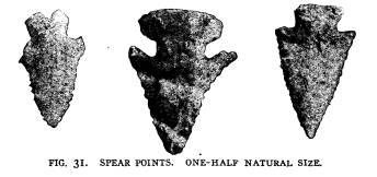
Fig. 30. The chipped implements used for spears and knives were also made of Flint Ridge material; these are of all colors, |
|
|
|
from the perfectly semi-transparent waxy, yellow, chalcedony, to the red and variegated jasper forms. These are shown in Fig. |
|
Explorations of the Gartner Mound and Village Site. 163
31. Numerous caches of roughly fashioned implements made of this same material were found throughout the village. These caches would number from 10 to 25. Some of these show that they were large flakes from the manufacture of implements. However a number of them show secondary chipping along one or more of the edges. In a number of graves these pieces were |
|
|
|
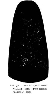
placed near the head of the skeleton and were undoubtedly used in the manufacture of the numerous bone implements which are so abundant throughout the entire village. Celts. - Stone celts were found in every portion of the vil- lage. They were made, for the most part, of granetic boulders, however, a few were made from banded slate and flint.. They |
|
|
|
varied in length from 2 to 6 inches and were highly polished. None were grooved, but many were roughly pecked for the attachment of a handle. These implements, as all others, were found in all stages of manufacture. Specimens were found where the peck- ing had just begun, in all cases boulders that were near the form of the object to be made, were selected. In other specimens the pecking was completed on one side, while the other had not been |
|
164 Ohio Arch. and Hist. Society Publications.
touched. In other specimens the pecking had been finished, while in others the grinding had just begun and so on up to the perfect specimens. These were found more numerous in the sites of their tepees. However, in a number of graves they were placed by the side of the skeleton; in one instance four were taken from the same grave. Fig. 32 gives a good illustration of the celt pro- |
|
|
cured from this village. Hammer Stones.- The hammer stones were very abundant in the village. Some of these are quite small and battered at one end, others at both ends, while still others are battered at both sides and ends. A number of these ham- mer stones are quite smooth upon one side, while on the other side they are slightly polished, showing that they were used in pounding some soft material, or had been covered with a skin and perhaps used as a club head. But the great- est use to which this hammer stone was, no doubt, placed was the breaking up of the various animal bones, for it is a very rare thing to find a perfect bone of any animal in this village, even to the very small- est. Net Sinkers. - A number of specimens have been found which |
|
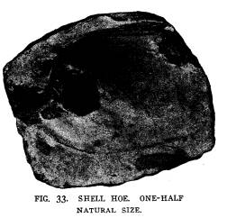
were merely pebbles that had been notched or grooved on two edges. These do not show any battered ends, as there is no doubt but that they were used as sinkers for the nets used in fishing. Hoes.- A number of large pieces of slate broken into form with notches or grooves cut on the sides were frequently found. These were, no doubt, used for agricultural implements. How- ever, the shell hoe, as shown in Fig. 33 is found in abundance |
|
Explorations of the Gartner Mound and Village Site. 165
and must have been universally used. The shell selected was that of the Unio plicatus, a very thick and heavy shell. |
|
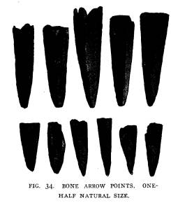
Bone Implements. - Points for arrows and spear-heads made from the tips of horn and the toe bones of the deer, as shown in Fig. 34, were very common, in fact more numerous than the chipped flint points. However, the majority of those found had been broken, but many perfect pieces, as can be seen in the illus- tration, as well as spec- imens showing every |
|
|
stage of the manufacture of this useful implement, were found. Although well versed in the art of flint chipping, these people |
|
|
were a considerable dis- tance from the source of supply of this much valued article, flint, and were compelled to resort to the supply of deer horn, that was brought to their very door. This would necessarily be procured during their hunting expeditions as well as finding them scattered over the sur- face during the season of the year when the deer shed their horns. Although more difficult to make, requiring to be |
|
166 Ohio Arch. and Hist. Society Publications.
drilled, dressed and polished to make a perfect point, they were more numerous than the flint-chipped points. Small caches of the tines of deer horns occur in various portions of the village, |
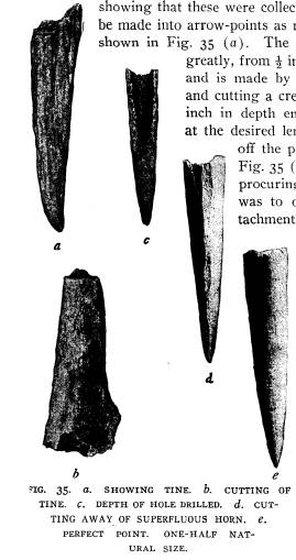
|
|
|
showing that these were collected and kept in store to be made into arrow-points as required. The tines are shown in Fig. 35 (a). The size of the point varies greatly, from 1/2 inch to 3 inches in length and is made by taking the broken tine and cutting a crease about 1-32nd of an inch in depth entirely around the horn at the desired length and then breaking off the point. This is shown in Fig. 35 (b). The first step after procuring the end of the tine was to drill a hole for the at- tachment of the wooden arrow- shaft. No work in fash- ioning the point seems to have been done until after this drilling was completed. The hole for the attachment of the shaft varied in depth from one-half to two-thirds the length of the point, see Fig. 35 (c), and always pyra- midal in form with a base diameter averag- ing about one-third of |
|
an inch. The majority of unfinished specimens show that the fashion- ing into form was done by cutting away the su- |
|
perfluous horn with a heavy piece of flint, as shown in Fig. 35 (d). Some writers have expressed the opinion that this cutting was done with a steel knife, but a careful examination by means |
Explorations of the Gartner Mound and
Village Site. 167
of a good hand glass will reveal the
concave appearance of the
cuts and the small scratches caused by
the uneaven fracture of
the flint. The final finish upon the
arrow-point was done by
rubbing the arrow-point upon a piece of
fine-grained sandstone,
thus removing all traces of cutting as
is shown in Fig. 35 (e),
which shows a symmetrical and
well-wrought point.
Bone implements were found which, no
doubt, served in the
preparation of skins and in the
manufacture of their wearing
apparel. Of these implements, the
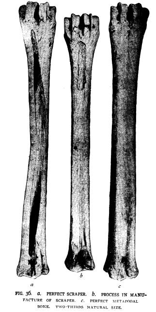
scraper, as shown in Fig.
36 (a), and made of the anterior and
posterior metapodal bones
of the deer and elk were found in small
numbers in a perfect
state. However, the broken parts were
found throughout the
entire village in great numbers, showing
that this implement was
universally used. Illustration Fig. 36
(c) shows a perfect an-
terior metapodal bone, and I may here
state that this is the
only perfect bone of the kind found in
the village, as all others
had either been broken or showed some
stage in the manufacture
of the scraper. Fig. 26 (b), shows a
process in the manufacture
of this implement and by careful
examination of the specimens
showing these stages, I am convinced
that they were made by
using a blunt-pointed flint implement.
Scrapers made from the
shoulder blades of the elk were also
found. The spine of the
shoulder blade was usually sharpened
into a knife-like form,
while the posterior and anterior border
and the postscapular, as
well as the prescapular portions, were
entirely removed. In sev-
eral instances instead of the spine
being sharpened, it was re-
moved and the suprascapular border would
be sharpened into a
knife-like edge. Very few perfect
specimens of the shoulder blade
of the elk were found, as they were
universally used in the manu-
facture of scrapers or awls. The
shoulder blades of the deer were
sparingly used for scrapers. However,
they were finished very
much like the scrapers made from the
shoulder blades of the
elk. A few very fine and perfect
scrapers made from the antlers
of the elk were found in various
portions of the village. These
were made from the heavy portions
between the beztine and the
trestine of the elk antler. They vary in
length from 3 to 6 inches
and in width from 11/2 to 3 inches.
These are of two kinds, those
sharpened at both ends, which were, no
doubt, used in the hand
|
168 Ohio Arch. and Hist. Society Publications. |
|
|
|
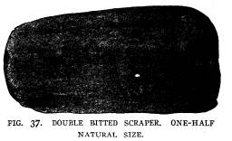
Explorations of the Gartner Mound and Village Site. 169
and were usually from 4 to 5 inches in length (see Fig. 37), and those sharpened at one end which were usually from 21/2 to 4 |
|
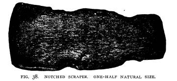
inches in length. A number of them have notches cut on the side at the unfinished end, showing that they were hafted in a wooden handle (see Fig. 38. Scrapers made from the heavy metapodal bones of |
|
|
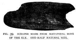
the elk were also found, these were made similar to those made from the antlers. A specimen of this implement is shown in Fig. |
|
|
|
39. These are from 2 to 3 inches long and were, no doubt, hafted in wooden handles. |
|
|
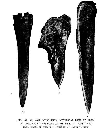
Awls were required for the manufacture of garments. Fig. 40 (a) is made of one- half of the distal end of the metapodal bone of the deer. This specimen was, no doubt, manufactured |
|
from a broken scraper. The awls made of this bone are very similar; none of them have sharp points, but gradually taper, as |
|
170 Ohio Arch. and Hist. Society Publications.
is shown in the illustration. Fig. 40 (b) is an awl made from the ulna of the deer. Awls of this kind are invariably sharp pointed and are found in every portion of the village. Fig. 40 (c) is an |
|
|
|
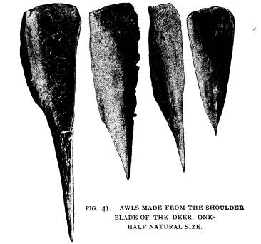
awl made from the ulna of the elk; this was highly polished, as is shown in the specimen. Fig. 41 shows four awls which may be taken as types found in every portion of the village; these are |
|
Explorations of the Gartner Mound and Village Site. 171
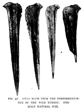
made from the shoulder blades of the deer. Fig. 42 is a good representation of awls made from the tarsometatarsus of the wild turkey. These awls are beautifully made and highly polished. Some of them are ornamented with incised lines and grooves, while others are perfectly plain. Awls made from this bone are the most common and are found in the graves, refuse pits and sites of the tepees. In the mussel bakes, previously described, scattered promiscuously among the shells were found a great |
|
|
|
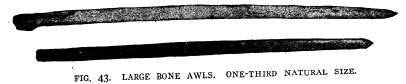
number of these bone awls and I am inclined to believe that these awls, as well as those shown in Figs. 7 and 43, may have been used for awls, but at the same time served a double purpose of awls and forks. Fig. 7 shows a large awl taken from a grave in the mound which is upward of 81/2 inches in length and is deco- rated at one end with a carved head of a fox or some closely allied animal. These large awls are very abundant and found in every portion of the village. Fig. 43 shows specimens which are |
|
172 Ohio Arch. and Hist. Society Publications.
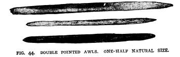
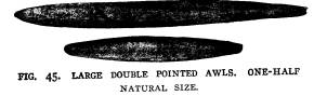
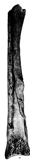
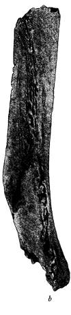
quite numerous, both in the graves and tepee sites. One of the most interesting of the bone implements found in the village site and graves is the double pointed awl. These vary in length from 11/2 to 6 inches. All are beautifully wrought and highly polished. The larger ones may have been used as perforators or hair pins. Fig. 44 (a, b and c) were taken from graves. These were in- variably found directly beneath the skull; (a) is made from the tibiotarsus of a bird; (b) is made from the heavy leg bone of the |
|
|
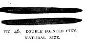
deer and (c) is made from antler. Fig. 45 shows two large dou- ble pointed awls which may have been used for spear-points; these two specimens were evidently made from the heavy leg bone of the elk or like animal. Fig. 46 shows two specimens which were no doubt used for pins. From one grave seven were taken from around the head and in another five, still others from two to four. In one of the refuse pits was found a concretion with seven of these small pins placed in regular |
|
order on the inside; with these were placed three bone beads. This is shown in Fig. 47. These pins are found in every por- tion of the village in great numbers and must have been gener- ally used. Needles, in the perfect state, made of bone are spar- ingly found in the village site. However, many broken needles were in evidence, especially in the refuse pits. All are provided with a circular eye, which is always placed at the largest end of |
|
Explorations of the Gartner Mound and Village Site. 173
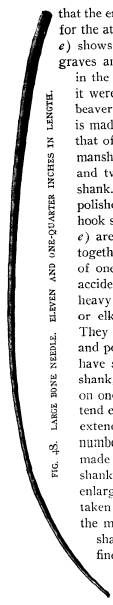
the needle. Fig. 48 illustrates a very fine needle, which is 111/4 inches in length and made from a rib of the elk, from which most |
|
|
|
of the needles are made. However, the greater part of the needles found are perfectly plain and highly polished; a few are orna- |
|
|
|
mented with incised lines. Another implement of bone found in this village is the knife. This is invariably made of the shoulder blade of the deer |
|
|
and elk. However, a few have been found made of the posterior portion of the metapodal bone of the deer, |
|
Fig. 49 (a). Fig. 49 (b) shows a knife from the shoulder blade of the deer, the spine is cut away and the poscapular and pre- |
|
scapular portion are sharpened into a blade-like double edge knife. These were found in goodly numbers in various portions of the village and were, no doubt, commonly used, Many bone tubes, made from the |
|
|
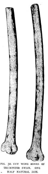
wing bones of the various large birds are found in refuse pits. Fig. 50 shows the cut wing bones of the trumpeter swan. These |
|
174 Ohio Arch. and Hist. Society Publications.
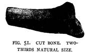
specimens were found together within a tepee site. Fig. 51 shows the end of one of these bones which had been cut off and thrown into one of the refuse pits some ten feet away. Fish Hooks. - The remains of fish, such as bones and scales found in the refuse pits, shows that fish formed one of the articles of food of these primitive people, and further that they employed |
|
|

|
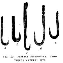
fish hooks, made of bone, as one means of procuring food, as evi- denced by the finding of perfect and broken hooks in this village. Less than one dozen perfect hooks have been found, while more than a score of broken ones were taken from the village as well as every stage in the manufacture of this implement. The hooks are similar in every respect, the only noticeable difference being |
|
Explorations of the Gartner Mound and Village Site. 175 |
|
|
|
that the end of the shank is usually enlarged or grooved for the attachment of the line. Fig. 52 (a, b, c. d, and e) shows five fish hooks. These were taken from the graves and refuse pits; (a) was taken from a burial in the village; it was placed near the head and with it were placed a number of the incisor teeth of the beaver and pins made of bone and horn. The hook is made from the tibiotarsus of some bird, perhaps that of the wild turkey. This hook is of fine work- manship and well polished. It has a round shank and two well-cut grooves in the upper end of the shank. The point of the hook is sharp and finely polished. Viewed horizontally from the end, this hook shows the marrow cavity of the bone. (d and e) are two finely wrought hooks which were found together. They were taken from near the center of one of the refuse pits and had, no doubt, been accidentally lost. These hooks are made from the heavy bone of some animal, perhaps that of the deer or elk, as neither side shows the marrow cavity. They are perfectly finished, of fine workmanship and perhaps excel in that particular any that we have so far found in the village. The top of the shank, as shown in (d) has five well-cut grooves on one side and four on the other; these do not ex- tend entirely around the shank. In (e) the grooves extend entirely around the shank and are three in number. (b) shows another well-wrought fish hook, made from the tibiotarsus of some large bird. The shank is flat and apparently unfinished, the top is enlarged for the attachment of the line. This was taken from the ashes which covered the platform in the mound. (c) is a very small hook with a long shank and enlarged top. The base of the hook is finely wrought and highly polished, while the upper part of the shank is practically finished, but rather rough and is not so highly pol- |
|
176 Ohio Arch. and Hist. Society Publications. |
|
ished as other specimens found in the village. This was found with a burial from the village site. Not only were the broken and perfect hooks found, but every stage in the manufacture |
|
|
|
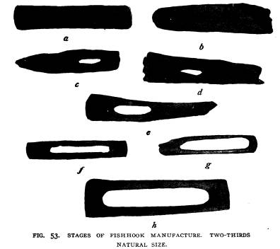
of this implement was brought to light. In Fig. 53 (a) is a piece of the tibiotarsus of the wild tur- key, which may be considered the first stage in the manufacture of this hook; (b) is the second stage when the work of cutting out the center has begun; (c, d, and e) are the next stages when the work has proceeded farther; (f) might be considered the next stage when the center has been practically cut away; (g) has entered the stage when one end has been practically finished; (h) is the last stage before the bone is cut and the hook made. Here the hooks are practically finished with the exception of the top of the shank for the attachment of the line and the point. By cut- ting the bone at the proper place at each end of this prepared bone, two hooks could be made instead of one. The hooks found in this village compare very favorably with those found at the Baum village, which is situated on Paint Creek, a tributary of the Scioto.* Of the fish hooks found in the Baum village all can be |
|
|
|
*A description of the fish hooks found at the Baum village site with a comparison of those found at Madisonville and other places was given, by the writer, in a short paper before the American Association for |
|
Explorations of the Gartner Mound and Village Site. 177 |
|
readily duplicated at the Gartner vil- lage, as well as the various stages in its manufacture. Woven Fabrics and Ornaments. Fragments of fabrics woven from veg- etable fibre were found in the graves, but more especially in the storehouses, where it had been charred and thus pre- served. This woven fabric was, no doubt, used for clothing as well as pouches, mats, etc., and in no case was any found except those that were charred so that the fabrics found were too fragmentary to determine the fibre from which they were made. In the bottom of the storehouses great quan- tities of corn, beans, and hickorynuts, were stored, with them would invaria- bly be found portions of pouches, used for carrying and collecting nuts and grain, and mats which, no doubt, cov- ered the bottom of the storehouses. Closely associated with the fabrics was the pottery, for upon almost every frag- ment of this much used domestic uten- sil was the imprint of a woven fabric. However, this is characteristic of the pottery of the Scioto valley. Personal ornaments of great variety were found in the graves and throughout the entire village, but more especially in the refuse pits, where they were, no doubt, acci- dentally thrown. For the most part they were made of shell, which consist- ed of two kinds, the common mussel shells obtained from the river, and the |
|
|
the Advancement of Science, which met in Baltimore, December 28, 1901. and was published in Vol. 7 of the Ohio State Archaeological and Histo- rical Society publications. Vol. XIII-- 12. |
|
178 Ohio Arch. and Hist. Society Publications. large and small ocean shells, no doubt obtained by barter. The larger ocean shells were cut and formed into gorgets, beads, and pendants, while the small ocean shells were usually pierced with a hole for attachment and no other work done upon them. The larger ocean shell gorgets which are shown in Figs. 12 and 13 |
|
|
were found with burials in the mound previously described. However, these gorgets were evidently highly polished originally, as in several places this polish still remains. The larger size is always made from the ocean shell and the smaller ones, as |
|
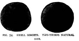
in Fig. 54 are about equally divided between the fresh-water mussel and ocean shells and vary in diameter from 3/4 to 11/4 inch. The gorget to the left in Fig. 54 is made from ocean shell and found with a skeleton in one of the mound burials. The other gorget, in the same figure, is made from the fresh-water mussel shell and was taken from a burial in the village site. These are |
|
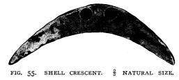
invariably pierced with a hole in the center which varies from 1/8 to 1/4 inch in diameter. These holes were, no doubt, set with pearls or stone, as is shown in Fig. 17. These gorgets are found throughout the entire village as well as every stage in the manufacture of this orna- ment. The crescent, as shown in Fig. 55, was taken from a grave in the village. The crescents made from |
|
|
shell are quite common in the burials of the Gartner mound, as well as those of the village. But as far as I have been able to ascertain they have not been found in any great numbers out- side of this particular place. During the three seasons of ex- plorations at the Baum village, not a single perfect or broken |
|
Explorations of the Gartner Mound and Village Site. 179
crescent was found, while every other ornament made of shell can readily be duplicated at the Baum village. |
|
|
|
Shell Beads. - The beads made of shell and averaging from 1/4 to 1/2 inch in diameter with a hole in the center, were very abun- |
|
dant, in some in- stances between seven and eight hundred were found with a single skeleton. The most of these beads were made from ocean shells. They are highly polished and |
|
|
show a high degree of skill in their manufacture. Shell Pendants. - The pendants were frequently made from shell, both ocean and fresh water, but the majority of them were |
|
180 Ohio Arch. and Hist. Society Publications.
made from the fresh-water mussel shell. They were cut into long strips averaging from 2 to 3 inches, and were pierced with a hole |
|
|
at the top for attach- ment. However, a number of them were triangular in form. These were usually from 1 to 11/2 inches in length and pierced with two holes at the |
|
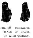
top for attachment. The greater number of these were found in the graves. Pendants and Beads Made of Bone. - Fig. 56 shows pen- dants made from the digits of the wild turkey. |
|
These occur in great numbers and are asso- ciated more particularly with the burials. Fig. 57 is an illustration of a necklace found in one of the refuse pits. It is made up of six canine teeth and six incisor teeth of the elk. Three |
|
|
of the canine teeth are perforated with two holes and three with one hole; three of the in- cisor teeth are perforated with one hole, while |
|
three have a crease cut entirely around the root of the tooth for attachment. The canine and incisor teeth of the elk were invari- |
|
|
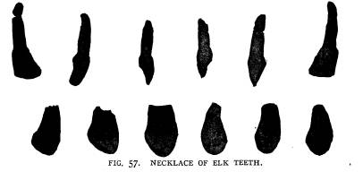
|
ably used for ornaments and in a number of instances bone beads and shell were combined to form a necklace, and invariably |
|
Explorations of the Gartner Mound and Village Site. 181
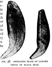
the incisor of the elk formed the pendant to this necklace. The canine teeth of the black bear (see Fig. 58) are found in abun- |
|
dance in this village; they were used for pendants and the per- forations are drilled from side to side through the base of the root. Many of them are much worn from long use. The most common of the ornaments used is the bone bead. These occur in great numbers everywhere and are associated with almost every necklace taken from the graves. They are usually made from the |
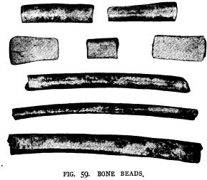
|
|
wing bones of the bird and especially that of the wild turkey and vary in length from 1 to 5 inches. In sev- eral instances as many as |
|
forty beads have been taken from a single refuse pit. These |
|
|
were scattered promiscuously through the de- bris and were, no doubt, lost from time to time. A good illustration of the beads is shown in Fig. 59. Fig. 60 is an illustration of the humerus of the wild turkey. Near the head of the humerus |
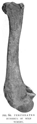
|
are three perforations on each side. To these, no doubt, were attached rattles or ornaments, which were carried in the hand. |
|
182 Ohio Arch. and Hist. Society Publications.
The perforated humeri of the wild turkey are occasionally met with in all sections of the village. They are not found in the graves, but usually occur in the refuse pits. Fig. 61 shows digit |
|
|
bones of the deer, one end of which has been re- moved and the other end perforated with a small hole. These are found in abundance in the re- fuse pits, but none of them have been taken from the graves. Fig. 62 shows cut jaws and heads of various animals. These are found Cthroughout the village, but none in the graves. Fig. 62 (a) is a cut jaw of the gray wolf show- ing carnatial tooth, and the two molars. This is evidently an unfinished piece, as perfect speci- mens are found in the village which show that the upper part of the jaw had been cut away so as to expose the ends of the roots. These were used for ornaments; (b) of Fig. 62 is the head and lower jaw of the mink. The pos- terior part of the skull has been cut away, ex- posing the brain cavity. The top of the skull shows deep cuts as well as the lower jaw, near the angle. These were, no doubt, made to se- cure the lower jaw to the skull and perhaps for attachment as an ornament. These speci- mens were taken from one of the refuse pits. The skull of the dog was also found in one of the refuse pits which had been treated in the same manner. Fig. 62 (c) is part of the left ramus of the mandible of the deer. In this specimen the jaw has been cut at the posterior end of the sym- physis, while at the posterior extremity the condyle and coronoid process has been broken away preparatory to the manufac- |
 |
|
ture into some ornament. Fig. 62 (d) shows the anterior portion of the ramus containing the incisor teeth. Fig. 62 (e) is the right ramus of the mandible of the wild cat, which has been cut similar to that of the deer just described. Fig. 62 (f) is a skull of the |
|
Explorations of the Gartner Mound and Village Site. 183 wild turkey. These are found in abundance everywhere in the village. The upper surface of the skulls are usually perforated with one or more holes and were, no doubt, used for rattles, as they were found in the graves, where they encircle the lower limbs just below the knee. These heads usually contain from one to five small round pebbles. Pipes. - The practice of smoking is indicated by the pres- ence of stone pipes, finished and unfinished, found in every sec- tion of the village. The pipes were made for the most part of fine grained sandstone; yet several were found made of greenish argillyte, while still others were made of clay resembling very much the clay used in making their pottery. The peculiar platform pipe shown in Fig. 9, taken from the |
|
mound, has not been duplicated in the village. However, another form of platform pipe is shown in Fig. 63, which seems to be the prevail- ing type of platform pipes. This specimen is made of greenish com- pact argillyte. The bowl is placed near the larger end, which is deco- rated with incised lines. In this particular specimen the bowl has been broken, but it fully illustrates |
|
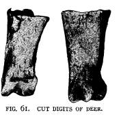
|
the type and the labor necessary in the manufacture of this abo- riginal artifact. Fig. 64 is another type of pipe found in this vil- lage. It is made of compact sandstone, while Fig. 65 taken from one of the refuse pits, is made of clay. The unfinished pieces found in this village show that a great amount of work has been required in their manufacture and that the work of pecking and rubbing is done first and the hole is drilled in the bowl next, and lastly the hole is drilled in the stem. Whetstones. - Whetstones are very common in the village site. They are simply pieces of fine grained sandstone which have been used to sharpen objects made of bone and in the manufac- ture of ornaments made of shell. The majority of these speci- mens are flat and have grooves cut into them caused, no doubt, by sharpening the needles and awls. However, some of these whet- |
|
184 Ohio Arch. and Hist. Society Publications.
stones are symmetrically cut, having edges and sides perfectly smooth, while others were simply finger-shaped pieces of fine- grained sandstone, which had been used upon all sides.
METHOD OF BURIAL IN THE VILLAGE. The dead were evidently buried in close proximity to the habitat of these people and were similar in every respect to the |
|
|
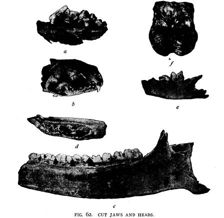
|
burials in the Baum village site, along Paint creek. Each family apparently had their own burial ground, which was in close prox- imity to the home. No evidence was found that the bodies had |
|
Explorations of the Gartner Mound and Village Site. 185
been placed upon scaffolds and afterward reinterred. In the ma- jority of the graves the body was placed at full length, as is |
|
|
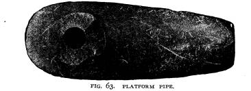
|
shown in Fig. 66 and with it was placed implements and orna- |
|
|
ments which, no doubt, represented the property of the deceased at the time of death. However, a single burial was found in the bottom of a refuse pit; a photograph of this burial is shown in Fig. 67, which shows that the body was |
|
made to conform to the size of the pit. The head is bent forward and the legs are flexed so that the feet are very near the pelvis; one arm is flexed parallel to the body with the hand near the head, while the other lays across the body. However, |
|
not many burials of this kind are found and it occurred to me that |
|
|
perhaps this was an emergency burial, occurring during the winter when the ground was frozen so that excava- tions could not be made, consequently the storehouse was cleaned out and the body placed therein and covered with a few inches of soil. It was afterward used as a refuse pit. Fig. 68 shows a double |
|
burial. By referring to this figure one can readily see that the legs and head are higher than the body. This was caused by |
|
Ohio Arch. and Hist. Society Publications.
digging the grave over a refuse pit. The head and feet extending beyond the confines of this pit, and as decomposition took place, the body would naturally sink, with the loose material, into the pit, leaving the legs and head higher than the other portions of the body. In this particular burial, which represents two old people, male and female, the bodies were buried side by side. The male to the right with the right arm under the skull of the female. |
|
|
|
With them were buried two finely-polished celts, which can be seen near the pelvic region and near the head two more were found similar to those just mentioned. Only one can be seen in the photograph. At the back of the head and between the two skeletons were placed a number of beads, ornaments of shell, fish hooks, beaver teeth, awls, pins, etc., which were, no doubt the property of these individuals. No remains of the cremated dead or evidence that cremation was practiced outside of the large crematory was discovered, |
|
Explorations of the Gartner Mound and Village Site. 187
which shows that the majority of the dead of the village were cremated and placed in the mound. The explorations of the Gartner mound, during the season of 1902, followed by the investigation in the village, which sur- rounds the mound, in 1903, have successfully proven that the primitive inhabitants of the village were the builders of the mound, as evidenced by the artifacts found in the ashes of the cremated |
|
|
|
dead and the regular burials of the mound, being similar in every respect to those found in the village. Further, that the culture of these primitive people was quite uniform and resembles in all the essential points the culture of the prehistoric inhabitants in the Paint Creek valley at the Baum village site. In the manu- facture of their pottery and especially in reference to their designs and shapes, their products were quite similar. In the manufac- ture of their implements, such as the fish hooks, scrapers, awls, and needles, and various implements in stone, as shown by the |
|
188 Ohio Arch. and Hist. Society Publications. |
|
|

|
Explorations of the Gartner Mound and Village Site. 189
various stages in the manufacture of these implements that they were in every respect similar to those at the Baum village. The ornaments of bone and shell taken from the mound and village can readily be duplicated at the Baum site with but one exception, namely, the shell crescent, which was found only at the Gartner site. The examination further shows that these people were agri- culturists, depending upon the products from the soil to tide them through the long winters, as shown by the storage of corn and beans in the subterranean storehouses dug for that purpose. Fur- ther that there was inter-tribal trade, as evidenced by the ocean shells and mica found in almost every portion of the village. This investigation has also brought out the fact that these primi- tive people had a domesticated dog, whose osteological charac- ter accords with that of the dog found at the Baum village site. |
|
|
EXPLORATIONS OF THE
GARTNER MOUND AND
VILLAGE SITE.
WM. C. MILLS, CURATOR OF THE STATE ARCH.
AND HIST. SOCIETY.
The Gartner mound, located partly upon
the land of Mr.
Adam Gartner and partly upon that of
Miss Elizabeth Lievy,
is situated about six miles north of
Chillicothe, on the east side
of the Scioto river. The river bank, at
this point, is quite high,
upward of 70 feet above low water mark,
and is very irregular,
with here and there spurs running up to
the river, which in
several instances are almost
perpendicular. The mound in ques-
tion is located upon one of these spurs.
However, this particular
spur is quite large and the banks are
not quite so abrupt as in
other places along the river. The north
side of the mound, or
the part situated upon the land of Miss
Lievy and which con-
stitutes about one-third of the mound,
had never been disturbed
by the plow and was covered with a dense
tangle of grape vines
and small trees; while the other
two-thirds upon the land of
Mr. Adam Gartner had been under
cultivation for a number
of years, consequently that portion had
been lowered about ten
inches. The mound at the time work began
was 7 feet 6 inches
in height, having a diameter of 75 feet.
Surrounding the mound
is the prehistoric village site similar
to the Baum village site,
which surrounds a large truncated
mound*. Around the mound,
upon all sides, particularly to the
south, are traces of former
Indian occupation. Numerous fragments of
pottery, similar in
texture and ornamental feature to those
found in the mound,
bestrew the ground. Intermingled with
these were the valves of
mussel shells, arrow-heads, pitted
stones, implements and orna-
ments made of bone, stone, and shell and
the bones of various
wild animals, which were used for food.
*The village site is situated along
Paint Creek a few miles south-
west of the small village of
Bourneville, Ross County, Ohio. A prelimin-
ary account is given in Vol. X. page 78,
of the Society's publications.
Vol.XIII-9. (129)
(614) 297-2300