Ohio History Journal
- 1
- 2
- 3
- 4
- 5
- 6
- 7
- 8
- 9
- 10
- 11
- 12
- 13
- 14
- 15
- 16
- 17
- 18
- 19
- 20
- 21
- 22
- 23
- 24
- 25
- 26
- 27
- 28
- 29
- 30
- 31
- 32
- 33
- 34
- 35
- 36
- 37
- 38
- 39
- 40
- 41
- 42
- 43
- 44
- 45
- 46
- 47
- 48
- 49
- 50
- 51
- 52
- 53
- 54
- 55
- 56
- 57
- 58
- 59
- 60
- 61
- 62
- 63
- 64
- 65
- 66
- 67
- 68
- 69
- 70
- 71
- 72
- 73
- 74
- 75
- 76
- 77
- 78
- 79
- 80
- 81
- 82
- 83
- 84
- 85
- 86
- 87
- 88
- 89
- 90
- 91
- 92
BAUM PREHISTORIC
VILLAGE.
WILLIAM C. MILLS.
The Baum Prehistoric Village site is
situated in Twin Town-
ship, Ross County, Ohio, just across the
river from the small
borough of Bourneville, upon the first
gravel terrace of Paint
Creek.
The Paint Creek valley is drained by
Paint Creek, a stream
of irregular turbulence, flowing in a
northeasterly direction, and
emptying into the Scioto River, south of
Chillicothe. The Valley,
at the site of this village upwards of
two miles in width, is sur-
rounded on the east and west by high
hills which are the land-
marks of nature, but little changed
since the days of the pre-
historic inhabitants.
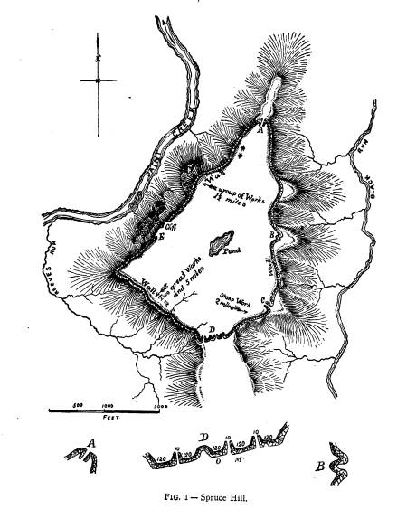
Spruce Hill, Fig. I, with steep slope
covered with a dense
forest, towers above the surrounding
hills on either side. The
top of this hill is made a veritable
fortress by an artificially con-
structed stone wall, enclosing more than
one hundred acres of
land. This fortress would no doubt
furnish a place of refuge to
those who might be driven from the
extensive fortifications in the
valley below, which are in close
proximity to the mounds and
village of those early people.
Looking to the south and east from the
village site, one can
see lofty hills rising in successive
terraces, no longer covered
with the deep tangled forest, but
transformed by the woodman's
axe, and now under cultivation,
producing the golden corn, which
is our inheritance from primitive man
who inhabited the Valley
of Paint Creek many centuries ago.
The village extends over ten acres or
more of ground, which
has been under cultivation for about
three-quarters of a century.
Almost in the center of this village,
near the edge of the terrace
to the west, is located a large square
mound. This mound and
the earthworks which are directly east
of it, have been known
since early times as the landmarks of
the early settlers in this
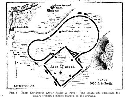
section of Ross county. The mound was
first described by Squier
45
|
46 Ohio Arch. and Hist. Society Publications. |
|
|
|
Explorations of the Baum Prehistoric Village Site. 47
and Davis in 1846, in their Ancient Monuments of the Mississippi Valley, page 57, where they give a description and drawing of these works (Fig. 2). However, Squier and Davis do not men- tion the fact that a village was present, nor that they knew of the village, as is shown by their description. "This work is sit- uated on the right bank of Paint Creek, fourteen miles distant from Chillicothe. It is but another combination of the figures composing the works belonging to this series just described; |
|
|
|
from which, in structure, it differs in no material respect, except that the walls are higher and heavier. It is one of the best preserved works in the valley; the only portion which is much injured being at that part of the great circle next to the hill, where the flow of water has obliterated the wall for some distance. The gateways of the square are con- siderably wider than those of the other works--being nearly seventy feet across. A large, square, truncated mound occurs at |
48 Ohio Arch. and Hist. Society Publications.
some distance to the north of this work.
It is one hundred and
twenty feet broad at the base, has an
area fifty feet square on
the top, and is fifteen feet high.
Quantities of coarse, broken
pottery are found on and around it. A
deep pit, or dug hole, is
near, denoting the spot whence the earth
composing the mound
was taken." This description,
though meager, attracted the at-
tention of the Bureau of Ethnology, and
they sent a field party,
under the direction of Mr. Middleton, to
explore the mound, and
I herewith quote from the twelfth annual
report of the Bureau
of Ethnology, 1890 and 1891. "The mound was composed for
the most part of clay, mottled
considerably with black loam and
slightly in some places with patches of
a grayish, plastic lime.
Cross trenches were run due north and
south and east and west,
respectively. The breadth of these at
the side was from five to
six feet, but as they penetrated inward
they widened gradually,
so that at the center the excavation
became thirteen feet in diam-
eter. Considerable lateral digging was
done from these trenches
to uncover skeletons and other
indications appearing in their sides.
"Two series of upright postmolds,
averaging five inches in
diameter equidistant ten inches, and
forming a perfect circle
twenty-six feet in diameter, constitute
a pre-eminent feature of
this mound. Within these circular
palings the mound was pene-
trated systematically by thin seams of
fine sand, sagging in the
center and averaging one foot apart.
Resting upon the natural
black loam at the bottom, timbers
averaging eight inches in di-
ameter radiated from the center, and in
the south and west
trenches were noticed to extend
continuously to the posts. These
timbers were detected, for the most
part, by their burnt remains
and also by the molds of dark earth in
the yellow clay, produced
by the decomposition of wood. Directly
over these timbers was
a horizontal line of decayed and burnt
wood, but mostly decayed,
averaging half an inch thick. The
upright postmolds of the lower
series were very distinct and measured
five feet in vertical height.
In one was found a small sliver of what
appeared to be black
walnut. Several of them contained the
burnt remains of wood,
and in many of these instances the black
bark was clinging to
the sides.
"Separating this from the
superstructure, as will be seen by
|
Explorations of the Baum Prehistoric Village Site. 49 reference to Fig. 3, was a thin, sagging streak of burnt clay. Here and there upon its surface scant traces of black wood ashes were seen, while a small quantity of white bone ashes lay scattered upon its western border. This burnt streak overlaid a thin sand seam, below which it seems it could not penetrate. The post- molds of the superstructure consisted of a double row, the outer one being uniformly directly over the lower series in a vertical line, and separated from the latter entirely around the circle by a solid line of gravel. The two rows of the upper structure |
|
|
|
averaged eighteen inches apart. Both might have extended orig- inally above the surface of the mound, since they were discovered between one and a half and two feet beneath the surface, which had been considerably plowed. Horizontal timber molds a little smaller in diameter, filled, in places, with charcoal, could be distinctly seen lying against the side of each line of posts at the points shown in the figure. These appear to have been cross beams or stays used for bracing purposes. In the eastern trench a gap, three feet wide and two inches deep, was noticed by the absence of postmolds in both upper and lower series. Vol. XV -4. |
50 Ohio Arch. and Hist. Society Publications.
"All the skeletons discovered were
in the area inclosed by
these posts. The skeletons unearthed
were all in a remarkably
good state of preservation. None of them
could have been in-
trusively buried, for the stratification
above them was not dis-
turbed. All excepting Nos. 15, 16 and 17
lay upon one or another
of the thin seams of sand.
"With skeleton No. 1 a bone
implement was found at the
back of the cranium, and an incised
shell and fragments of a jar
at the right side of it. With No. 3,
which was that of a child about
ten years old, a small clay vessel was
found five inches behind
the cranium. At the left hand of
skeleton No. 8 was a shell
such as is found in the sands of Paint
Creek. A bone imple-
ment was at the back of the cranium of
No. 9. With skeleton
No. 11, were found a lot of small
semi-perforated shell beads,
and two bone implements directly back of
the cranium. By the
right side of the cranium were the
perfect skull and jaws of a
wolf, and beneath these were two
perforated ornaments of shell.
In the right hand was a shell, such as
is found in the creek
near by, while in the left was a pipe
fashioned from stone.
"At the right of the feet of this
skeleton was the extremity
of an oblong ashpit, about four feet
long and two feet broad and
one foot ten inches in depth. It was filled with white ashes
which were evidently those of human
bones, since none but
human bones could be identified. In
these ashes and compactly
filled with them, was an earth pot. It
lay at the right of the
feet of skeleton No. 11. It was lifted
out of the ashes with
great care, but the weight of its
contents and its rotten condi-
tion caused it to break in pieces before
it could be placed upon
the ground. Numerous other pieces of
pottery of a similar char-
acter were found in these ashes, and it
is not improbable, from
the indications, that all these ashes
were originally placed in pots
before interment. A perforated shell
disk, two inches in diam-
eter, and a lump of soggy sycamore wood
were gathered from
the ashes. Neither wood nor shell bore
any signs of having
been burnt.
"Skeleton No. 15 lay seven feet
deep and a half foot below
the general burnt streak. It was
originally covered with a wooden
Explorations of the Baum Prehistoric
Village Site. 51
structure of some kind, for the cores of
two red cedar timbers
were resting lengthwise upon the body
and the burnt remains
of probably two others could be plainly
seen on each side, placed
parallel to those upon the body. This
red cedar was still sound,
but the white wood which envelopes the
red cores seemed to be
burnt entirely to charcoal. The
indications are that these tim-
bers were originally one foot above the
body, for the earth to
that extent over the whole length of the
body was very soft.
The timbers were noticed to extend
slightly beyond the head and
feet, while the head upon which they lay
was upon its right side.
The earth above them was a mixture of
clay and fine sand and
peculiarly moist. The length of this
skeleton to the ankle bones
was six feet and one inch. Two bone
implements were found
at its head, and at its right side near
the head were two frag-
ments of polished tubes and a
hollowpoint of bone, which ap-
pears to have been shaped with a steel
knife. Three bone im-
plements were found beneath the right
elbow of skeleton No. 13."
I have quoted at some length from the
Report of the Bureau
of Ethnology, because it is the only
account we have of the ma-
terial taken from the mound, which is
located almost in the
center of the village site.
However, the contents of the mound are
not available for
inspection, at the U. S. National
Museum, and we are compelled
to rely upon the description and drawing
given by the explorer,
Mr. Middleton, both in regard to mode of
burial and the arti-
facts placed in the grave. So far as I
am able to judge by hav-
ing before me the description of the
explorations of the mound
and the implements, ornaments and
pottery found in such pro-
fusion with the burials in the village,
I would say that the builders
of the mound were isochronological with
the dwellers in the
village. The bone arrowpoint mentioned
in the latter part of the
quotation as having the appearance of
having been shaped with
a steel knife, was duplicated many times
in every section of the
village, and was simply an unfinished
arrowpoint, having been
worked with a heavy piece of flint used
as a scraper, and not as
one would use a steel knife. An ordinary
pocket glass will reveal
the concave appearance of the cut, and
at the same time show
the scratches made by the uneven
fracture of flint. I have dis-
|
52 Ohio Arch. and Hist. Society Publications.
cussed at some length the making of arrowpoints, from the tips of the tines and the toe bones of the deer in the Explorations of the Gartner Mound and Village site, Ohio Arch. and Hist. Quarterly, Vol. XIII, No. 2. In 1897 Dr. Loveberry, under the direction of Prof. Moore- head, examined a small portion of this village, and I herewith quote from the conclusions of Prof. Moorehead, which are found in Vol. 7, page 151, of the publications of the Ohio State Archae- ological and Historical Society. |
|
|
|
"With other village sites of the Scioto this has much in common. While larger than the average, yet it can be said that it presents somewhat of a lower culture than others connected with great earthworks. It will be observed that there is not a great number of burial mounds within or without the enclosure. Those two to four miles west, along Paint Creek, may have been used by the occupants of the enclosure for their interments, but one cannot say positively. The character of the relics and the lack of evidence of high aboriginal art at this place are taken as evidence of the primitive character of the villagers. I do not |
Explorations of the Baum Prehistoric Village Site. 53
think that they were the same people who
erected the earth-
work, or of the same tribe. At
Hopewell's, Hopetown, Har-
ness's and the Mound City fragments of
elaborately carved shells,
rings, polished pipes, both effigy and
platform, etc., have been
found. None of these truly polished,
ceremonial, or artistic ob-
jects were found in the ash pits or on
the habitation sites of the
Baum village site. The place is
interesting in that it shows a
lower degree of culture than that
evinced on the sites above men-
tioned. This naturally brings forward
the question--Is this a
later occupation? Is it an earlier one?
I am convinced that it
antedates the construction of the works.
I do not think it is
of the historic period, and if Indian,
of some tribe which knew
little or naught of agriculture. No
pestles were found. The
bones of animals and the unios from the
creek, found in such
profusion, would indicate the presence
of a hunting tribe. No
foreign substances were present. Flint
Ridge material was ab-
sent. Neither the effigy of the fox, nor
the rude sculpture upon
the pipe can be classed with the
beautiful carvings of other Scioto
Valley culture-sites."
From the above quotations it will be seen
that the Baum
Mound and Village Site has had some
attention from the Archae-
ologist and was considered by them of
more than ordinary im-
portance.
In the following pages I give a detailed
account of the work
of three seasons in the village,
bringing to light forty-nine tepee
sites which were more or less the
permanent abode of the dwellers,
one hundred and twenty-seven burials
which surrounded the
tepees and two hundred and thirty-four
subterranean storehouses,
in which were stored the winter supplies
and which were after-
wards used for refuse pits.
During the summer of 1899, I examined a
section of the vil-
lage which lays directly south of the
mound, extending the work
to the west, and finally ending the work
of the season directly
north of the mound. During the summer of
1903, I examined
a large portion of the village directly
east of the mound, and
during the summer of 1902, sections were examined northeast
of the mound, extending along the edge
of the gravel terrace,
directly southeast of the mound.
|
54 Ohio Arch. and Hist. Society Publications. |
|
|

Explorations of the Baum Prehistoric
Village Site. 55
The examination of these various
sections were made to
discover, if possible, the extent of the
village, as well as to
ascertain the mode of life in the
various sections, and whether
the same people inhabited the village in
all its parts.
The land upon which this village is
situated has been owned
by the Baums for more than three
quarters of a century. At
the present time the land upon which the
village proper is situ-
ated is owned by Mr. J. E. Baum and Mr.
Pollard Hill, and
through the kindness of these gentlemen,
I was not in any way
restricted in my examination of the
village; in fact, they as-
sisted me in many ways to make the work
pleasant and profit-
able. About three quarters of a century
ago, Mr. Baum's grand-
father cleared this land, which was then
covered with a growth
of large trees of various kinds, such as
the black walnut, oak
sycamore, and ash, and it has
practically been under cultivation
ever since. The top surface consists of
from twelve to thirty-six
inches of leaf mould, and alluvial
deposit, which overlies a thin
stratum of compact clay. Directly
beneath this clay or hardpan,
is found gravel.
During the entire examination of this
village, something less
than two acres of ground was dug over,
and examined inch by
inch by the aid of the pick, spade and
small hand trowel, bringing
to light the habitations and burial
places of these early people.
No one living in this section, not even
those cultivating the
soil for the three quarters of a century
mentioned, knew that the
remains of a buried city of a
prehistoric people lay only a few
inches beneath the surface. As the
examination progressed it
was evident that a few pages, at least,
of the history of remote
time, were being revealed in the deep
pits, which served as sub-
terranean storehouses for the early
agriculturists. A few more
pages were brought to light when deep
down in the clay, the
burial grounds for each family were
discovered, and still a few
more pages when the tepee, with its
fireplace, stone mortars, im-
plements and ornaments, lying in
profusion upon the floor of the
little home, partially told in silent
language of the great drama
of life, enacted by those early people.
I herewith present a drawing, Fig. 6, of
a portion of the
|
56 Ohio Arch. and Hist. Society Publications. |
|
|
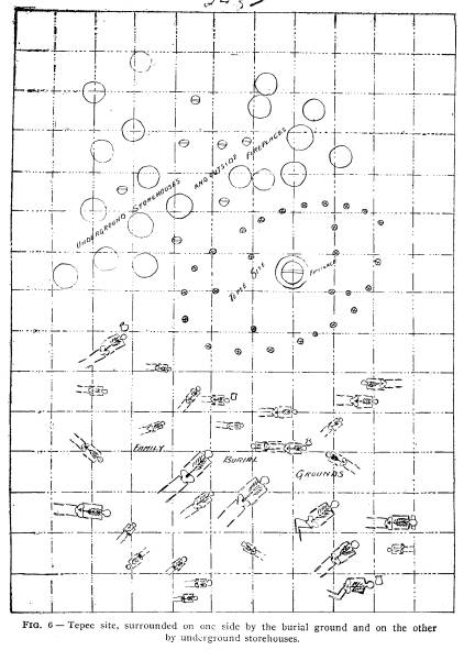
Explorations of the Baum Prehistoric
Village Site. 57
village farthest to the northeast of the
mound, which shows the
site of a large tepee, the largest found
during the explorations
and, perhaps, the most interesting in
this, that this tepee was
never changed and always occupied the
exact ground upon which
it was originally built, while in many
other instances the tepee
was shifted from place to place, even
occupying the ground used
for burial purposes, and the deserted
tepee site afterwards be-
ing used for the burial of the dead, or
for subterranean store-
houses. As I have stated, this tepee was
the largest found in
the village; of oblong construction and
measuring upwards of
twenty-one feet in length by twelve feet
in width inside of the
posts. The posts were large, as shown by
the postmolds, and
consisted of twenty-one set upright in
the ground, the smallest
being five inches in diameter and the
largest nine and one-fourth
inches. On the inside seven other posts
similar in size to the outer
ones were promiscuously placed,
presumably for the support of
the roof. The posts for the most part
consisted of the trunks of
small trees, with the bark attached,
placed in the ground. The
imprint of the bark was quite visible,
but the trees all being
young it would be impossible to identify
from the bark the kind
of trees used in the construction of the
tepee. The posts were
made the proper length by the use of
fire, and no doubt the
trees were felled by fire, for at the
bottom of the postmolds
charcoal was invariably found. The
covering of the tepee evi-
dently consisted of bark, grass or
skins, as no indications were
found pointing to the use of earth as a
mud plaster in the con-
struction of the sides or top. The
fireplace was placed in the
center of the tepee and was about four
feet in diameter, six inches
deep at the center and three inches deep
at the edge, and had
very much the appearance of having been
plastered from time to
time with successive layers of clay. The
earth beneath the fire-
place was burned a brick-red to the
depth of eight inches. The
original floor of the tepee had been
made fairly smooth, but almost
six inches of earth had little by little
and from time to time been
placed upon the floor. This earth had
scattered through it im-
plements and ornaments, both finished
and unfinished, polishing
|
58 Ohio Arch. and Hist. Society Publications.
stones, broken pottery, hammer stones, a large stone mortar, and many animal bones, especially of the deer, raccoon, bear, and wild turkey. As the animals named were most likely killed during the winter season, one must infer that the tepee was the scene of domestic activities during the winter, and that during |
|
|
|
the spring, summer and autumn the preparation of food was mostly done outside of the tepee at the large fireplaces marked upon the drawing (Fig. 6). However, the tepee described above is not typical of the village as far as size and shape and sur- roundings are concerned. The average tepee is about one-half the size and invariably circular in form, and the posts used in |
Explorations of the Baum Prehistoric
Village Site. 59
their construction much smaller. The
inside of the tepees are
practically all the same. The
surroundings of the tepee, such as
the subterranean storehouses and the
burial places, depend upon
the size of the tepee. Surrounding the
large tepee just described,
to the south was the burial ground where
thirty burials were
unearthed, the largest in the village.
Of these burials twenty
had not reached beyond the age of
adolescents, showing that
sixty-six and two-third per cent. of the
family group never
reached the adult age. Fourteen of the
twenty were under six
years of age, showing that the mortality
among small children
was very great, being fully seventy per
cent., not taking into ac-
count the four small babies found in the
refuse pits which sur-
rounded the tepee. The mortality of the
young under the adult
age in this family is greater than in
any other individual family
discovered in the village. Out of one
hundred and twenty-seven
burials unearthed in the village,
seventy-four were under the age
of sixteen, showing that fully
fifty-eight per cent. of the children
never reached the adult age. Of the
seventy-four children under
the age of sixteen, fifty-six were under
the age of six years,
showing that fully seventy-five per
cent. of the children born to
these early peoples died before they
attained the age of six years,
not taking into account the twenty-four
very small babies found
in the ashes and refuse in the abandoned
subterranean storehouses
in various parts of the village.
The burials of this wigwam group present
another interest-
ing feature, found in only one other
part of the village, that of
placing perfect pieces of pottery in the
grave. Four burials rep-
resenting five individuals, had each a
pottery vessel placed near
the head. All were carefully removed,
but were more or less
broken by freezing. The vessels have
been restored and will be
described elsewhere in this monograph.
Two of the vessels were
placed with adults and each contained a
single bone awl made
from the shoulder blade of the deer; a
few broken bones of the
deer and wild turkey were found in one,
and quite a number
of mussel shells with a few deer bones
were found in the other.
The other two vessels were placed in the
graves of children.
|
60 Ohio Arch. and Hist. Society Publications.
One with a double burial, as shown in Fig. 6, a few broken bones of the wild turkey were found in the vessel, together with two mussel shells worked into spoons. The vessel was placed near the head of the older child, whose age would not exceed four and one-half years. Two large bone awls made of the heavy leg bones of the elk were placed outside of the vessel and near the head, while in all the other burials where pottery was found, the awls were placed inside of the vessel. The other vessel contained |
|
|
|
bones of fish and a few small mussel shells, together with an awl made from the tibiotarsus of the wild turkey. Another interesting feature of one of the burials of this group and which was not found in any other section of the vil- lage, was the finding of a fine-grained sand-stone slab, nineteen and one-fourth inches long by five inches in width by one inch thick placed under the head of the skeleton. The slab had the appearance of having been water worn, but had received an ad- |
Explorations of the Baum Prehistoric
Village Site. 61
ditional polish by rubbing, the effect
being noticeable over the
entire surface of the stone. One side is
perfectly plain; the other
side, finely polished, contains three
indentations about one-eighth
of an inch deep, and three-fourths of an
inch in diameter.
Another feature of this interesting
group is the finding of a
few copper beads associated with shell
beads in one of the burials.
This find is the only instance where
copper was found during the
entire exploration in the village.
However, it shows that the
denizens were familiar with and
possessed this very desirable
metal.
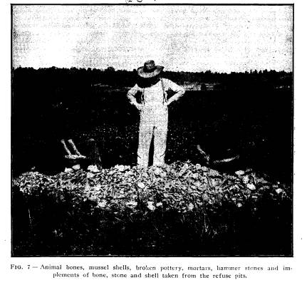
The refuse pits surrounding the tepee to
the north were per-
haps the most interesting in the
village, for here abundant evi-
dence was found showing that the refuse
pits were originally in-
tended and used for a storehouse for
corn, beans and nuts, and
perhaps, for the temporary storage of
animal food, etc., and
afterwards used as a receptacle for
refuse from the camp. For
some time I was of the opinion that the
large cistern-like holes
were dug for the express purpose of
getting rid of the refuse, but
as the explorations progressed I soon
discovered their real pur-
pose by finding the charred remains of
the ears of corn placed
in regular order on the bottom of the
pit; and I was further
rewarded by finding pits in various
sections of the village con-
taining charred corn, beans, hickory
nuts, walnuts, etc., which
had been stored in the pit and no doubt
accidentally destroyed.
Since completing my examination of the
Baum Village I ex-
amined the Gartner Mound as well as the
village site which sur-
rounded the mound, and find that the two
villages had very much
in common. The family grouping and the
subterranean store-
house were identical in every respect
with those at the Baum
Village, therefore, I quote from my
report upon this village site,
Vol. 13, page 128, publications of
the Ohio Archaeological and
Historical Society, including a
photograph of explorations at
Gartner's showing the close proximity of
the pits and the large
number exposed at one time: "The
refuse pits, which are so
abundant in the villages of the Paint
Creek valley, were present
in great numbers and distributed over
the village site surround-
62 Ohio Arch. and Hist. Society Publications.
ing the habitats of the various
families. Fig. No. 9 shows ten of
these pits open at one time. During the
examination in the vil-
lage, more than one hundred pits were
found and thoroughly ex-
amined. The evidence produced by this
examination shows that
twenty per cent. of the pits examined
were originally used for
storehouses for grain, beans and nuts,
and perhaps for animal
food. These pits were lined with straw
or bark and in some in-
stances the ears of corn laid in regular
order upon the bottom;
in other instances the corn was shelled
and placed in woven bags;
in others shelled corn and beans were
found together; in others
hickory nuts, walnuts, chestnuts and
seeds of the pawpaw were
present in goodly numbers. All this was
in the charred state, acci-
dentally caused, no doubt by fire being
blown into these pits and the
supplies practically destroyed before
the flames were subdued.
The burning of these supplies must have
been a great loss to
these primitive people and may have
caused them great suffer-
ing during the severe winters, but it
has left a record of their
industry which never could have been
ascertained in any other
way. The great number of pits found,
which show conclusively
by their charred remains their early
uses, would lead one to be-
lieve that all the pits found were used
originally for underground
storehouses and by spring time, when the
supplies were likely
consumed, a general forced cleaning up
of their domiciles and
surroundings would occur and the empty
storehouse would serve
as a receptacle for this refuse, which
was henceforth used for
that purpose until completely filled.
During the autumn, when
the harvest time came, a new storehouse
would be dug and the
grain and nuts gathered and stored for
winter use. The exam-
ination of the pits has brought out the
above conclusions, as
evidenced by the refuse therein. Near
the bottom of the pits will
invariably be found the heads of various
animals such as the
deer, with antlers attached, black bear,
raccoon, gray fox, rabbit
and the wild turkey, as well as the
large, heavy, broken bones of
these animals such as would likely be
found around a winter
camp. Further, some of the large bones
showed that they had
been gnawed in such a manner as to
indicate the presence of a
|
Explorations of the Baum Prehistoric Village Site. 63 |
|
|

64 Ohio Arch. and Hist. Society Publications.
domesticated dog, whose presence was
further corroborated by
finding his remains in every part of the
village. Therefore, tak-
ing all these facts into consideration,
one must necessarily infer
that the spring cleaning took place and
animal bones, broken
pottery and the general refuse was
thrown into the pits. Further,
the remains of fish are seldom ever
found near the bottom of the
pits, but usually occur from the top to
about the middle. Mussel
shells are never found at the bottom of
the pits, but are usually
found near the middle or half way
between the middle and top
of the pit. We know that fish and
mussels must be taken during
the spring, summer and autumn and are
certainly very hard to
procure during the winter." The
same conditions as described
above were found at Baum Village.
Another notable feature in this village
was the finding of
the Indian dog, and I quote from my
preliminary report, page
81, Vol. X, Publication of the Ohio
Archaeological and Historical
Society: "The bones of the old Indian
dog were found in great
numbers, and there is no doubt but that
this dog was one of
their domestic animals, for it is known
that dogs were domesti-
cated long before the earliest records
of history, their remains
being found in connection with the rude
implements of the
ancient cave and lake dwellers all
through Europe. However,
the history and description of the
Indian dog, in the ancient times,
is yet a subject far from solution. The
remains of the dog found
in this village site were described by
Professor Lucas, of the
Smithsonian Institute at Washington, as
being a short-faced dog,
much of the size and proportions of a
bull terrier, though prob-
ably not short-haired. Professor Lucas
says he has obtained spec-
imens apparently of the same breed from
the village sites in
Texas and from old Pueblos. Professor
Putnam, of Harvard
University, for more than twenty years
has been collecting bones
of dogs in connection with pre-historic
burials in various parts
of America, and a study of the skulls of
these dogs found in the
mounds and burial places in Florida,
Georgia, South Carolina,
Ohio, Kentucky and New York, and from
the great shell heaps
of Maine, show that a distinct variety
or species of dog was dis-
Explorations of the Baum Prehistoric
Village Site. 65
tributed over North America in
pre-Columbian times. Appar-
ently the same variety of dog is found
in the ancient site of the
Swiss Lake dwellers at Neufchatel, also
in the ancient tombs of
Thebes in Egypt. Professor Putnam
further says: "This variety
of dog is apparently identical with the
pure-bred Scotch Collie
of to-day. If this is the case, the
pre-historic dog in America,
Europe and Egypt and its persistence to
the present time as a
thoroughbred is suggestive of a distinct
species of the genus canis,
which was domesticated several thousand
years ago, and also that
the pre-historic dog in America was
brought to this continent by
very early emigrants from the old
world."
He further states: "That
comparisons have not been made
with dogs that have been found in the
tribes of the Southwest,
the ancient Mexicans, and with the
Eskimo."
In the latter part of the fifteenth
century Columbus found
two kinds of dogs in the West Indies and
later Fernandez de-
scribed three kinds of dogs in Mexico,
and as Professor Lucas
has been able to trace the Baum Village
dog into the far South-
west, it is very likely one of the kinds
described by Fernandez:
However, it must be admitted that
comparisons have not been
made with sufficient exactness to place
the Baum Village dog
with any of those described by the early
writers.
During the entire exploration fifty
bones of the dog were
removed, representing perhaps as many
individuals. Some of
the bones showed marks of the flint
knife upon them, others
were made into ornaments, while others
were broken in similar
manner to bones of the deer and raccoon.
Seven skulls were
found, but all had been broken in order
to remove the brain.
During the explorations at the Gartner
Village, which is lo-
cated six miles north of Chillicothe,
Ohio, along the Scioto River,
remains of the Indian dog were found in
the refuse pits similar
to those at the Baum Village, and their
osteological character ac-
cord in every respect with the dog found
at the Baum Village site.
FOOD RESOURCES.
From our examination of this village and
the evidence re-
vealed by the refuse pits and the sites
of their little homes shows
that these early inhabitants were not
savages depending entirely
Vol. XV- 5.
66 Ohio
Arch. and Hist. Society Publications.
upon the wild food for their
subsistence, but were barbarians hav-
ing a settled place of abode, a
developed agriculture, the storage
of food supplies for future use, and the
domestication of at least
one animal, namely, the Indian dog,
which of all animals would
best show adaptation to his master's
wants and pleasures.
ANIMAL FOOD.
It is evident from the large quantity of
animal remains found
in the pits, that the inhabitants of Baum Village site depended
upon the chase for a very large part of
their subsistence. Every-
where about the village, especially in
the abandoned storehouses
and in the sites of wigwams, the broken
bones of various ani-
mals, that were used as food, were found
in abundance. The
abandoned storehouse was a veritable
mine for animal bones. A
memorandum of all the bones taken from
one pit was made.
The pit measured three feet and seven
inches in diameter by
five feet ten inches in depth and
contained 375 bones and shells,
some of which were mere fragments, while
others, such as the
leg bones of the beaver, groundhog and
raccoon were in a per-
fect state. A summary of all the bones
and shells is as fol-
lows: Virginia deer, thirty-five per
cent.; wild turkey, ten per
cent.; two species of fresh water unios,
ten per cent; gray
fox, ten per cent.; raccoon, five per
cent.; black bear, five per
cent.; box turtle, five per cent.; the
remainder of the bones be-
ing divided about equally between the
groundhog, wild cat, elk,
opossum, beaver, rabbit, wild goose, and
great horned owl. By
far the largest number of bones were
those of the Virginia deer
(Odocoileus virginianus). Out of twenty barrels of bones
brought to the museum, fully thirty-five
per cent. were of this
animal. It will therefore be safe to say
that thirty-five per
cent. of all the animals used for food
by these aboriginal inhab-
itants of Baum Village were the Virginia
deer. At the Gartner
Village, six miles north of Chillicothe,
this animal constituted
fully fifty per cent. of all the animals
used for food.
The general characteristic of the deer
at Baum Village was
similar to the modern species. The
antlers have a sub-basal snag
beyond which the beam is curved forward
and soon after forks
Explorations of the Baum Prehistoric
Village Site. 67
dichotomously, the lower fork again
forking, presenting a beam
with three practical vertical tines
rising above it, thus demon-
strating that the Virginia deer has
remained practically unchanged
since the time of these aboriginal
inhabitants.
During the explorations three hundred
and fifty lower jaws
were removed from the refuse pits, which
would represent about
that number of individual animals. Of
this number only one jaw
has been removed in perfect condition,
the others being more or
less broken. Out of the three hundred
and fifty jaws examined,
fifty seven were from young deer under
the age of maturity, and
sixty-two were those of old animals
having their teeth very much
worn. In the remainder the teeth were in
a perfect condition,
and showed that the animal had reached
the age of maturity.
Fifty skulls of this animal were
procured from the refuse
pits, and only two, or four per cent. of
the fifty were females,
and the remaining forty-eight or
ninety-six per cent. were males.
Seventy-four per cent. of the males were
killed during the Fall
and Winter seasons, while only
twenty-two per cent. were killed
during the Spring and Summer. The small
per cent. of female
skulls shows that aboriginal man, in the
killing of animals, made
a selection with reference to the
perpetuation of the source of
supply. Moreover, the great quantity of
animals killed during
the Fall and Winter, shows that the
huntsman depended largely
upon animal food to tide him through the
Winter. In the other
seasons, corn, beans and nuts of various
kinds furnished him
his subsistence.
Elk (Cervus canadensis) -Is the largest mammal found in
the village. The bones of this animal
are not abundant in the refuse
pits, perhaps on account of the
difficulty in securing such a large
and fleet animal. Almost every pit would
reveal a few bones,
and these were broken into small pieces,
not a single perfect
large bone being found, as all had been
broken into small frag-
ments in order that every particle of
attached food might be
obtained. The large pieces of the heavy
leg bones were made
into awls and other implements, and the
metapodal bones into
scrapers; likewise every portion of the
large antlers were utilized
in the manufacture of celt-like
scrapers, flaking tools and spear
points.
68
Ohio Arch. and Hist. Society Publications.
Black Bear (Ursus americanus) -Appear in goodly num-
bers in every section of the village.
Twenty-three broken skulls
were removed from the pits, all having
the posterior portions
broken away in order that the brain
might be removed. Seventy
lower jaws were found, but all were
imperfect, the defects be-
ing caused by the removal of the canine
teeth, which necessi-
tated destroying the jaw. The canines of
the bear are the only
teeth used for ornament, and are usually
perforated with a small
hole near the end of the root for
attachment.
Wolf (Canis occidentalis)--Is another large animal found
very sparingly in the refuse pits, and
must have been very dif-
ficult to capture. During the entire
exploration only one head
was found with the teeth in place,
although quite a number of
upper and lower jaws cut into ornaments
were found. The large
leg bones were also broken into
fragments or made into imple-
ments. The canine teeth were perforated
near the end of the
root for attachment. The posterior
premolars were invariably re-
moved from the jaw and perforated for
attachment.
Mountain Lion (Felis concolor) -The bones of this animal
are not met with in abundance in this
village, although several
of the large leg bones have been found
as well as various por-
tions of seven skulls. The broken bones
are sparingly found in
every portion of the village, and the
teeth, such as the canines, the
upper posterior premolars and the lower
molars were perforated
and used as ornaments.
Wild Cat (Lynx rufa) - The bones of this animal are found
in great abundance in every section of
the village. Portions of
thirty skulls and parts of one hundred
and twenty-five lower
jaws were secured. Only a few perfect
leg bones were found
and these showed plainly the marks of
the flint knife in remov-
ing the flesh from the bones. The canine
teeth were much sought
after for ornament and not a single
lower jaw taken from this
village has the canine teeth in place.
Raccoon (Procyon lotor)--The bones of the racoon are
more abundant in this village than any
other animal belonging
to the order Carnivora, although every
family of the order is
represented. The bones for the most part
were broken and not
more than ten perfect femurs were
secured. Thirty-five frag-
Explorations of
the Baum Prehistoric Village Site. 69
mentary skulls, one
perfect skull and two hundred and twenty-
seven parts of lower
jaws were taken from the pits. The perfect
skull was that of a
very old animal. The upper canine teeth
seem to be the only
teeth selected from the raccoon for orna-
ment. Many of the leg
bones were made into beads, and the
fibulas were
invariably made into awls or perforators.
Gray Fox (Urocyon virginianus) -This animal was
cer-
tainly plentiful in
this section of the Paint Creek Valley, as the
bones are found in
every part of the village. During the ex-
plorations over two
hundred lower jaws and over twenty frag-
mentary skulls were
secured.
Indian Dog (Canis) - This animal was found
in every sec-
tion of the village
and I have described this dog at some length
in the preceding
pages.
The dental formula is
as follows:
I. 3-3 C. 1-1 . P. 4-4 M. 2-2 =
42.
3-3 1-1
4-4 3-3
The canine teeth of
the lower jaw are quite large and strong,
the inner edge of
each being quite sharp. The first molar is large
with chisel-shaped
cones upon the surface of the anterior part
of the tooth, while
the posterior part is very large and flattened,
but has a number of
small cusps arising from the edge of the
tooth; this molar is
much larger than the second and third
combined. In the
upper jaw the first, second and third premolars
are very much alike,
although the first is single-rooted and not
so large. The fourth
premolar is very large, with cone-shaped
cusps arising from
the crown, the inner part chisel-shaped in
form. The two molars
are very different, although in general
character alike, as
the first is very much smaller than the second,
and both set at right
angles to the premolars. The outside of
the anterior molar is
made up of two large cone-shaped cusps,
while the inside of
the tooth is very large and flattened and the
crown low; likewise
the second molar has two cone-shaped cusps
upon the outside of
the tooth, but much smaller in size.
There is no doubt but
that this dog was a domesticated
animal and lived in
the village, as proof of his presence is man-
ifest in almost every
section of the village by finding many
large pieces of bones
that had been gnawed. This discovery led
70 Ohio Arch. and Hist.
Society Publications.
me to believe, even before the remains
of the dog itself were
found, that his presence in the village
would be discovered. The
dog was also used for food, as his bones
were broken in a man-
ner similar to those of other animals
employed for food.
Skunk (Mephitis mephitica) was not found in abundance in
the village, though almost every tepee
site would reveal some
broken bones of this animal. During the
examination five im-
perfect skulls, two perfect skulls, and
twenty lower jaws were
found. The skulls were broken similar to
other animals, in order
to remove the brain, which was no doubt
used for food.
Mink (Putorius vison) -The bones of this
animal were
occasionally met with in every section of
the village. The bones
of such a small animal would readily be
destroyed by the Indian
dog. Three perfect skulls, ten
imperfect, and thirty-one lower
jaws were secured during the
explorations.
Otter (Lutra canadensis) - The remains of this
animal are
met with quite frequently. Twenty
fragmentary skulls and parts
of 23 lower jaws were secured. Not a
single perfect specimen
of the larger bones was found.
Fisher (Mustela pennanti) -
The remains of this animal are
sparingly met with and only two broken
parts of the upper jaw
with a portion of skull attached, and
five lower jaws, were found
among the entire explorations in the
village.
Opossum (Didelphs virginianus) - The remains of
this ani-
mal are found in more or less abundance
in the village, although
but few remains are found in the refuse
pits. Twenty imperfect
skulls and twenty-five parts of lower
jaws were found. The
upper canine teeth were much sought
after for ornament, per-
haps on account of their size and
general appearance, being long
and gracefully curved.
Ground Hog (Arctomys monax) - The remains of this ani-
mal were found in abundance in the
refuse pits. One perfect
skull, thirty imperfect skulls and one
hundred and five parts of
the lower jaw were secured.
Beaver (Castor canadensis) - The beaver is well represented
among the animal remains found in the
village. Fifty parts
of skulls and about the same number of
parts of lower jaws were
secured. The incisor teeth were highly
prized by aboriginal man
Explorations of the Baum Prehistoric
Village Site. 71
when cut and made into ornaments and
cutting tools. The large
leg bones were also found unbroken and
might be considered
the best preserved in the village.
Musk Rat (Fiber zibethicus) -The bones of this animal are
not found as frequently as either the
Ground Hog or the Beaver.
One perfect skull and parts of three
imperfect skulls were taken
from the refuse pits.
Rabbit (Lepus sylvaticus) -The remains of the rabbit are
found in all parts of the village. Two
perfect, and parts of two
imperfect skulls were found, but the
large bones of the skele-
ton were everywhere abundant.
Gray Squirrel (Sciurus carolinensis) -The remains of the
squirrel appear in great numbers,
although but parts of two
skulls were secured during the
explorations, and then only in
the last season's work in the village,
however, the various bones
of the squirrel were abundantly found in
almost every tepee site.
Weasel (Mustela vulgaris) -The bones of this small ani-
mal are occasionally met with in the
village, though it is rea-
sonable to believe that the bones of
this animal, as well as those
of other small animals, would be totally
destroyed by the Indian
dog. Portions of three skulls and five
lower jaws were found.
Rice Field Mouse (Oryzomys palustrus) -The rice field
mouse is found in great numbers in the
refuse pits, attracted
there evidently by the grain and nuts
stored for food.
Box Turtle (Cestudo virginea) - The bones of the
common
box-turtle are very abundant in the
village. From one pit alone
fifty-nine carapaces were removed, which
no doubt represented
a turtle feast. The carapaces were
frequently cut and made into
drinking vessels and spoons.
Snapping-turtle (Chelydra serpentina)- This turtle is also
found in all parts of the village, but
not so plentiful as the box-
turtle.
Wild Turkey (Meleogris gallaparo) - Fully eighty per cent.
of all the bones of birds found in the
village site belong to the
wild turkey. The flesh of this bird was
certainly highly prized
for food. The large leg and wing bones
were made into im-
plements and ornaments and the skulls
into rattles.
72 Ohio Arch. and Hist.
Society Publications.
Great Horned Owl (Bubo virginianus) - The bones of this
bird are sparingly met with, as
they were highly prized for
making ornaments, and the majority of
the large bones were cut
into beads.
Barred Owl (Syrnium varium) -The bones of the
barred
owl are occassionally met with. As with
the great horned owl,
the bones were made into ornaments.
Canada Goose (Branta canadensis) -
The humerus of this
bird was found quite frequently, but the
other large bones were
manufactured into implements and
ornaments.
Trumpeter Swan (Olor
buccinator)--Like the Canada
Goose, only humeri of this large bird
are found, and those spar-
ingly.
Great Blue Heron (Ardea herodias) -Only a few bones of
this bird were found.
Bald Eagle (Haliaetus leucocephalus) -Only a few bones
of the Eagle have been found - one
skull, several ends of large
wing and leg bones that were left from
the manufacture of some
ornament, and a few claws.
Mallard Duck (Anas boochas) Pintail (Dafila acuta) and
Canvas-back (Aythya vallisneria) are found frequently in the re-
fuse pits. Several skulls of each were
found.
The presence of great numbers of mussel
shells, both in the
pits and surrounding the tepee sites,
would indicate that this
shell fish was much used for food. At
the Gartner Village the
remains of large mussel bakes were
found,* but the large pits
used in the preparation of the mussels
for feasts were not found
at the Baum site. However, large holes,
from which earth had
been taken, perhaps for use in the
construction of the mound,
were filled with the shells, and
surrounding pits also contained
great numbers of the shells, indicating
that a great feast had
taken place, and that the mussels were
prepared in a way similar
to those at the Gartner mound.
* Accounts of the mussel bakes are given
in the Pub. of the Ohio
State Archaeological and Historical
Society, Vol. XIII.
Explorations of the Baum Prehistoric
Village Site. 73
PLANT FOOD.
In order to secure data of certain
cultures in each coun-
try, historical records are quite
important and help to deter-
mine the origin of certain agricultural
products. These rec-
ords show that agriculture came
originally from three great re-
gions which had no communications with
each other, namely,
China, South West Asia and Egypt, and
inter-tropical America,
and from these three regions began great
civilizations based upon
agriculture. However, we find that
history is at fault in giv-
ing us much early data concerning the
third great center of civ-
ilization which does not even date from
the first centuries of
the Christian era, but we know from the
widespread cultiva-
tion of corn, beans, sweet potatoes and
tobacco, north and south
of the center of the American
civilization, that a very much
greater antiquity, perhaps several
thousand years, must be given
for the perfection of these plants up to
the time when history
begins.
The finding of charred corn, beans, nuts
and seeds of fruits,
and even the remains of dried fruit, in
the subterranean store-
houses in various parts of the Baum
Village, leads one to believe
that the early inhabitants were
agriculturists enjoying a certain
degree of civilization. The most
important product raised was
corn-Zea mays.* At the time of the discovery of America in
1492,
corn was one of the staples of its agriculture, and was
found distributed from the La Plata Valley to almost every
portion of Central and Southern United
States. The natives
living in this vast region had names for
corn in their respec-
tive languages. A number of eminent
botanists have made care-
ful explorations to find corn in the
conditions of a wild plant,
but without success.
The corn unearthed in the village was
always in the aban-
doned subterranean storehouses and
invariably at the bottom of
the pit. When any quantity was found the
charred lining of
the storehouse was present, which lining
frequently consisted
of long grass and sometimes bark. The
corn, when found in
* The identification of the corn, beans,
nuts and seeds from the
Baum Village was made by Professor J. H.
Schaffer of the Dept. of
Botany, Ohio State University.
74 Ohio Arch. and Hist. Society Publications.
the ear, was laid in regular order,
devoid of the husk, and con-
sisted of two varieties, an eight rowed
and a ten-rowed variety.
The eight-rowed variety had a cob about
half an inch in diam-
eter and short, while the cob of the
ten-rowed variety was larger
and longer. The grains and cobs having
been charred, were in
a good state of preservation.
In other pits the corn had been shelled
and placed in a
woven bag and the charred, massed grains
were removed in
large lumps with portions of the woven
bag attached. There-
fore it seems reasonable to believe from
the presence of so many
storehouses for the care and
preservation of their most nutritious
agricultural product, that corn was the
one staple upon which
prehistoric man depended to tide him
through the cold winters,
and until the harvest came again.
Kidney Bean (Phaseolus vulgaris)-According to J. S. New-
berry, who published the first flora of
the State (1859), the wild
bean occurs generally throughout the
State. This bean is found
in abundance in the pits, sometimes
mixed with shelled corn
and placed in a container, and sometimes
placed in the store-
house along with nuts and dried fruit of
the wild plum, and
was no doubt one of the agricultural
products of aboriginal man
of the Baum Village Site. According to
the latest discoveries,
in the Peruvian tombs of Ancon and other
South American tombs,
the origin of the bean was perhaps in
the intertropical Ameri-
can civilization, and no doubt spread
northward to the Missis-
sippi Valley similar to maize. Beans
were found also in the
storehouses at the Gartner Village,* and
in some of the burials
of the Harness Mound explored in 1905. Three species
of
hickory nuts were found in abundance in
the storehouse. Hicoria
ovata (shell bark) was taken from almost every pit where the
shells were found. Some of the perfect,
charred nuts were found
in the bottom of pits associated with
corn and beans, but the
ashes thrown into the pits from their
fire-places usually contained
many charred shells of this nut.
Hicoria minima (Bitter-nut) and Hicoria laciniosa were also
found in the ashes, but not so plentiful
as the shell-bark.
* Explorations
of the Gartner Mound and Village Site, Vol. XIII.
Explorations of the Baum Prehistoric
Village Site. 75
Butternuts (Juglans cinera) and Walnuts (Juglans nigra)
were both found in the perfect charred
state in the storehouses
and the ashes from the fire-places
contained many shells.
Papaw seed (Asiminan triloba) and Hazelnut (Corylus amer-
icana) were also found in the bottom of
the storehouse.
Chestnut (Castanea dentata) found in small quantities in var-
ious parts of the village.
Wild Red Plum (Prunis
americanus) -The seeds were
found in the ashes and the charred
remains of the fruit with seed
were taken from one of the storehouses.
Wild Grape (Vitis (op) ) was found sparingly in a few of
the pits.
PREPARATION OF FOOD.
Food, for the most part, both animal and
vegetable,
was prepared by cooking, as evidenced by
the large fire-
places, the innumerable pieces of broken
pottery, and the mor-
tars and stone pestles used in crushing
the corn, dried meats,
fruits and berries. The fireplace was
always present within the
tepee, and several of them could always
be found outside of the
tepee and in close proximity to it. The
fireplaces often show re-
pair. When the hollow in the ground
became too deep by long
use it was filled up to the proper depth
by mud plaster. The
necessary precautions were not taken to
remove all the ashes
from the fireplace before the plaster
was applied, consequently
when the fire was again placed in the
fireplace it soon cracked
loose, and portions of burned clay were
removed with the ashes
from time to time as the fireplaces were
cleaned, and the ashes
with the broken lining were thrown into
the pits. The large
stone mortars, as shown in Fig. 10, were
found in every section
of the Village, and were made from slabs
of fine-grained sand-
stone, averaging in size from ten to
fifteen inches in length, from
seven to twelve inches wide, and from
four to seven inches in
thickness, with a depression on one
side, in many cases only
about one inch deep, while in others the
depression would be
several inches. The stone pestles used
in crushing corn and
preparing food to be cooked, were not
selected with any great
care nor was very much labor expended in
their manufacture, as
many of them were merely natural
pebbles, suitable as to size
|
76 Ohio Arch. and Hist. Society Publications.
and weight, slightly changed by a little pecking or rubbing, while others were natural flat and rounded pebbles, having a small de- pression cut on each side. None of the bell-shaped pestles found at the Gartner Village were found at the Baum Village, although the preparation of food products was the same. The use of pottery in the preparation of food was universal. |
|
|

|
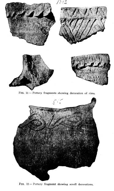
Everywhere in the village fragments of broken vessels, as shown in Figs. 11, 12 and 13, were found. Around the fireplaces both in and out of the tepee, pottery fragments were always present, showing that the pottery was broken while being used as a cook- ing utensil. The large pieces were gathered up and thrown into the open refuse pits near at hand, and here we find them quite often with particles of the charred food clinging to the sides of the broken vessels. The potter's art seems to have been |
|
Explorations of the Baum Prehistoric Village Site. 77 |
|
|
|
78 Ohio Arch. and Hist. Society Publications.
known and practiced by each family group. They became ex- pert in successfully tempering clay to strengthen it, and in then carrying it through all the stages of modeling, ornamenting, |
|
|

|
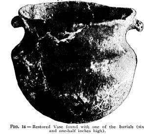
drying, and at last burning. Referring to Fig. 14, found with one of the burials, and which represents the highest type of fictile art found at the Baum Village, one can see the result of the pro- |
|
Explorations of the Baum Prehistoric Village Site. 79 gressive operations of a very delicate and difficult nature which required skill, foresight, patience, and wide experience in the |
|
|
Ceramic art to produce such sym- metry and grace as is displayed in this vessel. The decorations were those made by textile markings, and occur over the entire surface of the vessel. The impressions were no doubt made with a paddle around which cords had been wrapped. The handles are dec- |
|
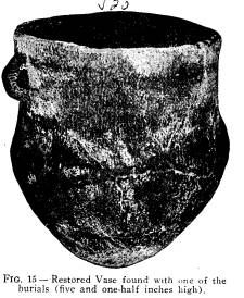
orated by indentations. Fig. 15 represents a vessel taken from another burial in the same family group. This vessel is also |
|
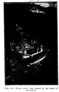
symmetrically made and the markings were made evi- dently with a pliable cloth, as they are uniform over the entire surface, including the handles. Fig. 16 shows a vessel placed near the head of the skeleton and which has been broken by freezing, as the burial was less than twenty-eight inches deep. Consequently all the pottery found in the burials of the Baum Village is more or less broken, but by carefully pre- serving the pieces, the ves- sel may usually be restored. |
|
|
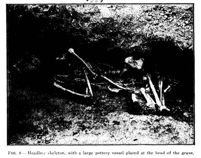
80 Ohio Arch. and Hist. Society Publications.
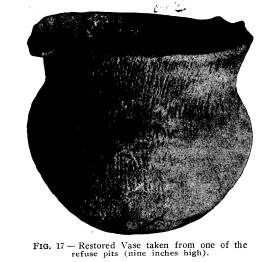
Fig. 17 is another restored vessel taken from the bottom of one of the storehouses in another section of the Village. The vessel had evidently been used as a container for grain and was accidentally broken in the pit and left there. Fortunately we secured all the pieces and were ably to fully restore the beau- tiful vessel. It is the largest one that we have been able to restore, although many others that were very much larger lacked only a few pieces to fully restore them. The restored vessel |
|
|
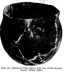
is nine inches high, with a diameter of nine and one-half inches at the largest part of the bowl. Fig. 18 is of a very plain vessel taken from a grave in another part of the village. This vessel has also been re- stored, and is s even inches high and eight inches in diameter at the widest part of the bowl. The vessel is perfectly plain, which is characteristic of about all the pottery fragments taken from this particular family group. Fig. 8 shows this same vessel before it was removed from the grave. The skeleton is |
|
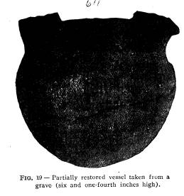
headless, and the vessel is placed where the head should have been when the body was placed in the grave. Fig. 19 is another vessel found with a burial. The vessel was fully restored with the exception of a piece of the rim, which had been broken out before being placed in the grave. The dec- |
|
Explorations of the Baum Prehistoric Village Site. 81
orations are textile markings, and the impressions are very pro- nounced over the entire surface. |
|
|
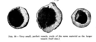
Fig. 20 shows very small vessels which were occasionally found in the perfect state; however, the broken pieces were found in every section of the village. The smallest of these vessels have the appearance of having been moulded over the end of the finger, while the largest is about the size of a small teacup. They were all rudely made and undecorated. Implements: The im- plements used in the |
|
chase and for domestic and agricultural purposes were found in great numbers in the abandoned storehouses and the sites of the |
|
tepees. For the most part they were made from bone and horn, but implements made from flint and grani- tic bowlders were in evidence in all sec- tions of the village. The implements used for agricultural pur- poses and for exca- vating for the store- houses were made for the most part of large mussel shells. Im- plements made of wood Vol. XV - 6 |
|
|
82 Ohio Arch. and Hist. Society Publications.
largely used, as charred remains of digging sticks and pieces of wood that had been polished were frequently met with. |
|
|
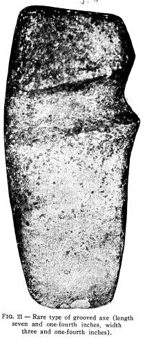
Stone Implements - The largest of the stone implements, with the exception of the stone mortars pre- viously described, were the grooved axes, which were sparingly found in the pits and tepee sites, two speci- mens having been found during the en- tire explorations, one in a tepee site and one in a refuse pit. The stone axe found in the tepee site is shown in Fig. 21. It |
|
is made of fine-grained blue granite rock, seven and one-fourth inches long, three and one-fourth inches wide. The surface shows the pecking, which had not been entirely obliterated by |
|
|
|
the grinding and polishing necessary for its completion. An interesting feature of this axe is the angle at which the groove |
|
Explorations of the Baum Prehistoric Village Site. 83 |
|
is cut to the blade. This type of axe is quite rare in Ohio, and not over four specimens are on exhibition in the mu- seum of the Society. The other axe found in one of the pits is an entirely dif- ferent type, the groove ex- tending entirely around the axe. It is made from the same compact stone as the axe described above, and is finished much in the same manner. Celts--This most useful implement was frequently met with in all sections of the village, and ranges in size from two to six inches in |
|
|
|
length. All are finely polished. Fig. 22 shows a typical celt found in the village. The celts were made for the most part from compact granite bowlders; others of banded slate and flint. Specimens illus- trating the various stages in the |
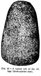
84
Ohio Arch. and Hist. Society Publications.
manufacture of the celt were secured
during the explorations.
Celts were frequently placed with the
burials. One was the
usual number placed in the grave, though
in several instances
two were found, and in the grave of a
large adult male, three
celts were placed in different parts of
the grave-one at the
feet, left hand and head, respectively.
The pits revealed many
broken celts, showing that the implement
was in general use.
Hammer Stones -The hammerstones, if abundance is to be
taken into account, were perhaps, the
most useful stone imple-
ments found at the Baum Village. In the
site of a single
tepee twenty-five to thirty would be
unearthed, and very often
as many would be taken from a single
pit. They were made
of small, water-worn bowlders, with a
diameter of two to four
inches, and the only evidence upon some
of the specimens show-
ing that they were used as hammerstones
was the battered ends
or sides; while others were artistically
smoothed and polished
on various sides, and perhaps covered
with a skin and used as
a club-head. However, it was not
necessary for aboriginal man
to expend unnecessary work upon an
implement when a natural
bowlder from the river near at hand
would answer the purpose.
Therefore it seems natural to believe
that all the bowlders of
proper size found in the village were
more or less utilized in
preparing meal, cracking nuts, breaking
bones of animals used
for food, etc.
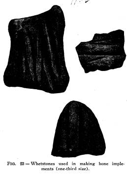
Grinding or Polishing Stones - Very good examples of this
most useful implement are shown in Fig.
23. They are usually
made of a fine-grained sandstone,* but
numerous pieces of coarse
grained sandstone taken from the top of
the hills, southwest of
the village were also found. The
grinding stones were indis-
pensible in the manufacture of the great
variety of bone im-
plements found in the village, and
varied in size from a slab of
sandstone one foot in length by a few
inches in thickness, to a
small piece of sandstone only a few
inches long and one inch in
thickness.
Chipped implements of flint were found
in every section of
the village, both the finished and
unfinished specimens, and were
*Waverly group.
|
Explorations of the Baum Prehistoric Village Site. 85 |
|
|
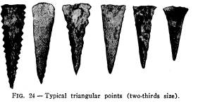
made, for the most part, from flint pro- cured from the Flint Ridge section, and showing about all the grades secured at this famous prehistoric quarry. The colors also varied from the white or gray horn stone through the various shades of chalcedony to the variegated and banded jasper forms. The greater part of the flint was brought to the village in large pieces, and there worked into imple- ments, as several large pieces of flint |
|
were found and the chips were everywhere present. The most abundant of all the objects made from flint were the small, tri- angular arrowheads, as shown in Fig. 24, which represents all the small triangular forms found in the village. Points with smooth edges were more abundant than those with serrated edges, and points having their edges both serrated and smooth are not uncommon. The |
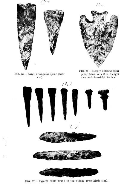
|
triangular form also predominates in the larger forms of spears, as shown in Fig. 25. The spear to the left is a type found in every section of the vil- |
|
|
86 Ohio Arch. and Hist. Society Publications. |
|
|
|
Explorations of the Baum Prehistoric Village Site. 87
lage. The beautiful spear point shown in Fig. 26 shows that the in- habitants of Baum Village were able to make points other than the triangular forms. This spear point is made of dark flint, having a |
|
|
|
very thin blade, deep notches, and an indented base, two and four- fifth inches long, and one and nine-tenth inches wide. Flint Drills, varying in length from two to four inches, were also abundant. Two kinds of drills were found: those having |
|
|
one point and usually small, and those having two points and much larger, but all have the same general appearance. Fig. 27 shows speci- mens which may be considered typ- ical drills found in the village. Flint Knives- |
|
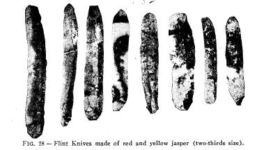
The flint knives flaked from the large jasper cores are also present. The knives are not large, and vary in length from one and one-half to three inches. Fig. 28 shows representative spec- |
|
88 Ohio Arch. and Hist. Society Publications.
imens made from banded and variegated jasper, showing sev- eral facets on the convex face, while the concave face is per- |
|
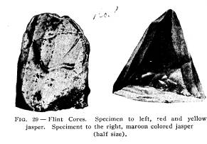
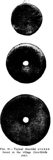
fectly plain and always regular and smooth -due to the fine grain of the chalcedony and jasper. Very few, if any, knives found in the village present any chipping, and all have the same general curve from end to end. The cores from which the knives are flaked are shown in Fig. 29, which represents the two types of cores found in the village, the conical core from which knives are flaked from all sides, and the flat core from which knives are flaked from one side only. The latter type prevails in the village. A large number of angular pieces of flint from one to one and a half inches in diameter were found in small caches near the site of the tepees, and quite frequently these angular pieces were found in the burials and were perhaps used to cut bone and horn, which were used in the manufacture of bone imple- ments. Discoidal Stones - Both per- fect and broken specimens were frequently met with in the refuse found in the abandoned storehouses. All of them were of small size, the largest not exceeding four inches in diameter, and the smallest less than one inch in diameter. Three types were found, the bi-concave, |
|
|
perforated at the center with a circular hole, the bi-concave un- perforated, and discs with perfectly flat sides. The bi-concave |
|
Explorations of the Baum Prehistoric Village Site. 89
with perforation, is the most abundant, and is made for the most part of diorite, and highly polished. The perforations are usually circular, but the finest specimen found in the village and made of quartzite had an oblong perforation. The specimen is shown in No. 2 of Fig. 30. Other specimens of this type were moulded out of tempered clay, the same as used in making pottery, but apparently were too fragile to be of great use, as all were broken. The second type, bi-concave unperforated, were larger than those that were perforated, but in every other respect similar. The third type or flat disc, which is also shown in Fig. 30, is of two kinds, plain and decorated. The plain are usually made of finegrained sandstone or pieces of pottery cut into form, |
|
|
whi1e the decorated speci- mens are invariably made of finegrained sandstone. The decorations consist of lines cut into the stones and radi- ating from the center of the disc; some of the lines ex- tend to the edge while others only part way. Several lines usually encircle the flat face. The decoration usually oc- curs on both sides. This type is also shown in No. 3 of Fig. 30. Hoes-The hoes found in the village were made, for the most part, of shells of the fresh water unios, but |
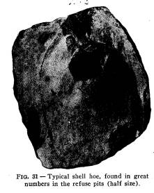
|
hoes made from the Waverly black slate were frequently met with. The hoes made from slate were roughly cut from slabs of about the desired size, but hoes made from mussel shells were very abundant. A typical specimen is shown in Fig. 31. The shells selected were usually those of Unio plicatus, which are of good size, and the shell meets the requirements of being thick and heavy. The majority of the specimens are greatly worn, showing that they had served their purpose. The imple- |
|
90 Ohio Arch. and Hist. Society Publications.
ment, when useless, was thrown into the refuse pits or left on the surface within the tepee, to be covered with soil the same as other implements, and the bones of various animals. Bone Implements - Bone implements, such as arrow points, scrapers, awls, needles, fish hooks, etc., were very abundant everywhere in the village, especially in the abandoned storehouses and in the sites of their habitats. Here were also found speci- mens showing all the stages in the manufacture of any one implement; bone objects, such as bones that gave promise of meeting the requirements for a certain implement, but after work had continued to a certain stage were found defective. Small caches of deer tines, probably collected during a hunting expe- dition, were found hidden for future use in some part of the tepee site. Bones of about all the animals used for food were |
|
|
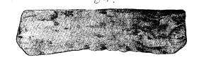
|
used in the making of implements of all kinds, and very rarely would any of the large bones of such animals as the deer, elk and bear be found in a perfect state, as all were used in the in- dustrial arts of these early inhabitants. For a long time it was thought that prehistoric man had only stone tips or points for his arrows, but when their tumuli and villages were examined points were found made of bone, and during the examination at the Baum Village the bone and stone points taken from the pits were about equally divided as to numbers. The bone points, for the most part, were made from the tines of deer horns. The horns were found in num- bers, but the tines were always removed. Fig. 32 is a good example of the horns as they came from the pits. The perfect and well-wrought arrow points made from horn are shown in Fig. 33. The methods of manufacture of the arrow point at |
|
Explorations of the Baum Prehistoric Village Site. 91 |
|
|
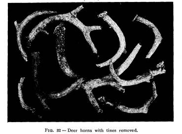
|
the Baum Village are identical with those at the Gartner Vil- lage Site, and I quote from my report upon this village site: "The size of the point varies greatly, from one-half to three inches in length, and is made by taking the broken tine and cut- |
|
|
ting a crease about one- thirty-second of an inch in depth entirely around the horn at the desired length and then breaking off the point. This is shown in Fig. 34 (b). The first step after procuring the end of the tine was to drill a hole for the attachment of the wooden arrow shaft. No work in fashioning the point seems to have been done until after this drill- ing was completed. The hole for the attachment of |
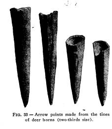
|
92 Ohio Arch. and Hist. Society Publications.
the shaft varied in depth from one-half to two-thirds the length of the point, see Fig. 34 (c),and always pyramidal in form, with a base diameter averaging about one-third of an inch. The majority of the unfinished specimens show that the |
|
|
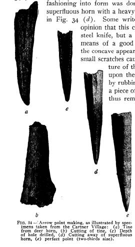
|
fashioning into form was done by cutting away the superfluous horn with a heavy piece of flint, as shown in Fig. 34 (d). Some writers have expressed the opinion that this cutting was done with a steel knife, but a careful examination by means of a good hand glass will reveal the concave appearance of the cuts and the small scratches caused by the uneven frac- ture of the flint. The final finish upon the arrow point was done by rubbing the arrow point upon a piece of fine-grained sandstone, thus removing all traces of cut- ting, as is shown in Fig. 34 (e), which shows a symmetrical and well-wrought point." The majority of the bone arrowheads were attached to the shaft by having the shaft fitted to the hole drilled in the base of the point, but a number of points were found having sec- ondary holes drilled into the side of the row point making, as illustrated by spec- n from the Cartner Village: (a) Tine point, as shown in Fig. horn (b) Cutting of tine, (c) Depth illed, (d) Cutting away of superfluous 35. All the points thus perfect point (two-thirds size). drilled were finely |
|
made, perhaps to serve as harpoons, by being attached to the shaft with a cord. Another short and small point made from the tone bones of the deer was also found. A good illustration |
|
Explorations of the Baum Prehistoric Village Site. 93
of this point and the stages in its manufacture is shown in Fig. 36. The first specimen to the right is a deer toe with a hole drilled in the base for the attachment of the shaft. The drilling |
|
|
of the hole for the attachment to the shaft was likewise the first step in mak- ing the arrowpoint from the tines of the deer horn, as illustrated in Fig. 34. The cutting away of the super- fluous bone of the deer toe was accom- plished in the same manner as shown in the cutting of the deer horn. Bone Scrapers-Of all the bone implements found in the village, the bone scraper, made from the metapodal bones of the deer and elk, is the largest bone specimen found, and varies in length from eight to fourteen inches. Fig 37 shows a representative collec- |
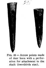
|
tion of the perfect scrapers. During the explorations fifty per- fect specimens were removed from the refuse pits, together with several hundred broken halves, showing that this implement was universally used in every section of the village examined. No record was made of finding a single perfect scraper in a tepee site, but frequently the broken pieces were found within the habitat; but for the most part the broken and the practically worn-out perfect scrapers were thrown into the refuse pits. The |
|
scrapers were invariably made from the metapodal bones, and very frequently the specimens were found showing that the foot of the animal was attached to the implement when it was discarded. Specimens showing the stages in the manufacture of the implement |
|
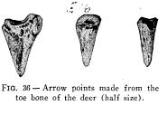
|
were occasionally met with. Fig. 38 shows three specimens. The first specimen to the left is a perfect metapodal bone, only two being found during the entire exploration. This bone was sel- dom found except in a condition showing that it had served as |
|
94 Ohio Arch. and Hist. Society Publications. some implement. The specimen in the center of Fig. 38 shows a process in the manufacture of this implement. In this case the work had not advanced very far, but it shows plainly the small parallel grooves which were no doubt made by a blunt- |
|
|
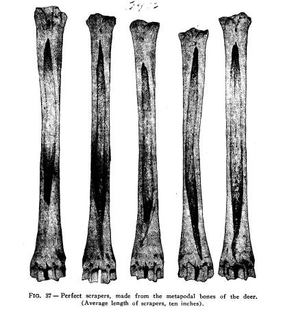
|
pointed flint implement. The specimen to the right in Fig. 38 is a perfect scraper, worn to a very thin edge from use. The surface of the bone at the ends shows a high polish. Scrapers were also made from the shoulder blades of the deer and elk, |
|
Explorations of the Baum Prehistoric Village Site. 95 |
|
|
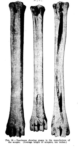
96 Ohio Arch. and Hist.
Society Publications.
especially of the elk. The spine was
frequently removed and
the supra scapular border would be
sharpened into a cutting
edge, and frequently specimens were met
with in which the
spine was sharpened to form a cutting
edge and the posterior
and anterior border and the post
scapular and prescapular por-
tions were removed. The shoulder blade
of the elk was always
converted into this most useful
implement, for not a single spec-
imen was found that did not show this
use. The shoulder blades
of the deer were not always converted
into implements, but very
frequently they were met with;
occasionally from a single pit
a half dozen or more would be taken, not
a single one showing
any marks upon it indicating it had been
used for any purpose,
while in other pits the same number
might be taken and all show
use as a scraper.
One of the most interesting of the
implements found in the
village is the celt-like scrapers made
from the heavy portions
between the beztine and the trestine of
the elk antler. From
the standpoint of utility, this
implement used as a scraper would
meet the needs to a better advantage
than any of those just de-
scribed; however, when the labor
necessary to produce speci-
mens as shown in Fig. 39 is taken into
consideration, we do not
wonder at the abundance of the simpler
forms. The cutting of
such a large and thick horn into the
proper lengths, which was
done by burning a ring around the horn
at the point to be cut
off, to a depth of perhaps one-fourth of
an inch, and then break-
ing the piece off, required much
patience as well as skill. After
the proper length had been obtained, in
order to secure the large,
flat pieces of the horn the desired
size, they were cut off with
a piece of flint, chipped to the proper
edge and used to plow a
groove one-fourth of an inch in depth
lengthwise of the horn.
A second groove was made at the proper
place and the slab of
horn split off. The work of grinding and
polishing would take
place later, but all requiring an
unusual amount of labor, per-
haps more than any implement made of
bone found in the vil-
lage. Three types of these scrapers are
found in the village:
those having both ends made into a
cutting edge, those having
one end made into a cutting edge with
one end sharpened, and
those having notches cut on the side for
attachment to a handle.
|
Explorations of the Baum Prehistoric Village Site. 97
All three types were about equally represented, although only a small number were found (fifteen specimens). The average length of the horn scrapers would not exceed four inches, though one was found eight and one-half inches long. The lower spec- imen in Fig. 39 is a scraper having two ends sharpened to a cut- ting edge; it is four and three-quarter inches long and two inches. wide, while the upper specimen is of the notched type. Bone Awls --Bone awls may be considered the most abun- dant of the many bone implements found in the Baum Village, |
|
|
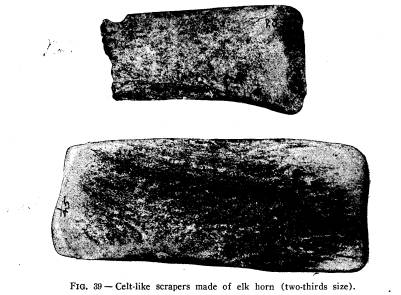
|
and the bones of about all the animals and birds used for food were used in the manufacture of the various types of awls. Many of them were manufactured from the heavy leg bones of the elk. Very good examples are shown in Fig. 40. These awls show a great amount of patience and labor in working down this thick bone, as shown by the enlarged portions, while others made from the same kind of bone are worked down to three-sixteenths of an inch in diameter and eight inches in length, with a well-wrought head sometimes carved representing the Vol. XV-7 |
|
98 Ohio Arch. and Hist. Society Publications. |
|
head of some animal. Awls showing much labor and skill in their manufacture were found in every section of the village as- sociated with others that required but little, labor to furnish a very serviceable imple- ment. The awls found at Baum Village may be considered under three classes: First, awls with blunt points, such as shown in Fig. 41 and Fig. 42. These awls for the most part came from the burials and were found associated with bones of animals placed in the grave as a food offering, and several were found in the pottery placed with the dead. Awls shown in Fig. 43 and Fig. 44 would always be found with mussel shells and animal bones where any quantity was placed together. Sum- ming up all the points observed concerning the blunt-pointed awls, one must believe that they served as forks in the prepara- tion of food, and in conveying food to the mouth, such as meat, mussels, and vege- tables. Many of the large and heavy awls may have been used in the manufacture of cloth and pottery. The second class of awls may be considered as bone perfora- tors, all having sharp and long points. The best examples of this class are shown in Fig. 45, and are made from the tarsome- tatarsus of the wild turkey. This class are very abundant. Out of two hundred and thirty-four pits examined there were very few that did not produce a perfect or broken awl of this class. Many awls of this class were made from the fibula and other bones of the raccoon. Fig. 46 shows an awl made from the lower jaw of the deer. With |
|
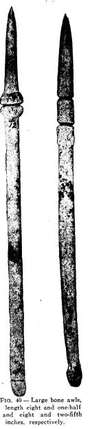
|
Explorations of the Baum Prehistoric Village Site. 99 |
|
|
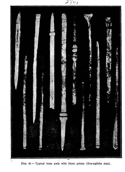
|
100 Ohio Arch. and Hist. Society Publications.
many of the burials in the village this class of awls are found. Fig. 47 shows five large awls of this class, four around the head and one between the legs near the feet. Beneath the mussel shells at the back of the head a large, well-wrought awl of the first class was found. The third class of awls are the double-pointed, sometimes called pins. They range in size from one inch in |
|
length for the very small awls to six inches in length for the largest. Fig. 48 gives a good illustration of the doub1e-pointed awls. This class is the most abun- dant in the village, especially in the refuse pits. They are also frequently met with in the graves, and are always near the head. But little work is required in the man- ufacture of the small pins, as they are quite frequently made of splinters of bone having the desired size and shape, and require but little rubbing to remove the sharp edges and fit them for a ser- viceable implement. How- ever, the large specimens have equally as much work upon them as the awls of the first class. Needles- Perfect needles are not found in |
|
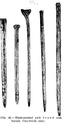
|
abundance in the village, although the broken pieces are fre- quently met with. The needle is made for the most part from the rib of the elk, which is cut off at the desired length, and then the rib is split and both pieces are manufactured into needles. The pieces are worked down to a little less than one- sixteenth of an inch in thickness and the average length being |
|
Explorations of the Baum Prehistoric Village Site. 101 |
|
about six inches. They frequently curve throughout their entire length, while others curve more near the point. The needle from this village is uniform throughout with the ex- ception of a slightly en- larged head, which is pierced with a circular eye, the point being not sharp or pointed, but an oval. Fig. 49 is an il- lustration of the needle, but does not do justice to this well-wrought and highly-polished imp1e- ment. Bone Knives- |
|
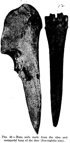
|
|
Another useful implement found at the Baum Site is the knife made from points of the shoulder blade of both the deer and elk, and not infrequently the bones of other animals whose bones would in any way be suitable for such an implement. The bone knife could not take the place of the flaked flint knife with its sharp cutting edge. |
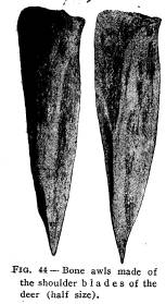
|
102 Ohio Arch. and Hist. Society Publications. |
|
Bone Tubes - A number of bone tubes, made from various bones of animals and birds were frequently met with. Fig. 50 shows two examples of tubes. The specimen to the left is made from the femur of the moun- tain lion. The distal ex- tremity has been cut away and the inside of the bone removed. The outside part of the shaft has been cut and polished. The head of the femur has also been cut away and the large trocantor slightly polished. The spec- imen to the right in Fig. 50 is made from the humerous of the Trumpeter Swan. The two extremities of the shaft are cut away and the |
|
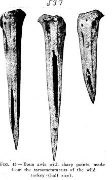
|
shaft shows cutting and polishing in various places over its sur- face. Tubes are also made from the femurs of the deer and the tibiotarsus of the wild turkey. Implements Made of Beaver Teeth - The bones of the beaver were seldom used to make implements or ornaments, but the incisor teeth, both upper and lower, were used in making im- plements. The three lower specimens shown in Fig. 51 have |
|
|
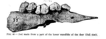
|
|

|
103 |
|
104 Ohio Arch. and Hist. Society Publications.
been shaped into desired implements which may have been ser- viceable as chisels in cutting bone and wood. The three upper specimens were no doubt used as ornaments when their useful- ness as implements were destroyed, as a number of beaver teeth |
|
|
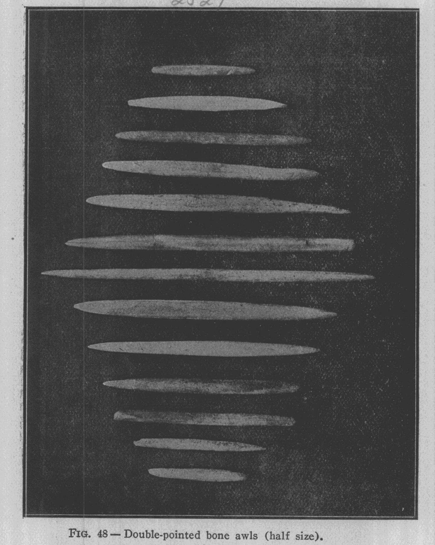
|
like the above were found associated with beads and pendants in one of the burials. Spear Points Made of Horn - Spear points made of horn, as shown in Fig. 52, were sparingly met with. They vary in |
|
Explorations of the Baum Prehistoric Village Site. 105
length from two and one-half to four inches, and the imple- ment shows but a small amount of labor in its manufacture. All are roughly and unsystematically made from flat pieces of deer |
|
and elk horn. Implements Used in F1aking Knives - The specimens shown in Fig. 53 were no doubt used in flak- ing the large flint knives so common in the village. The flaking tools were always made of deer and elk |
|
|
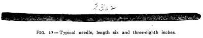
|
horn, and varied in length from one and one-half inches to four inches, and in diameter from one-half inch to three-fourths inch. One end is square, while the other end is oval, the longest point being in the middle of the speci- men. The square end on almost all the speci- mens shows a splintered and battered condition, indicating that the im- plement had been struck with a heavy blow. The oval end also frequently shows a splintered con- dition, caused by im- properly placing the tool against the flint, and striking the blow. The flaking tools are found everywhere in the vil- |
|
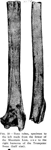
|
lage, especially in the sites of the tepees and in the graves. Fish Hooks-This implement is one of the most interest- ing of the great variety of bone implements found in the village, |
|
106 Ohio Arch. and Hist. Society Publications. |
|
|
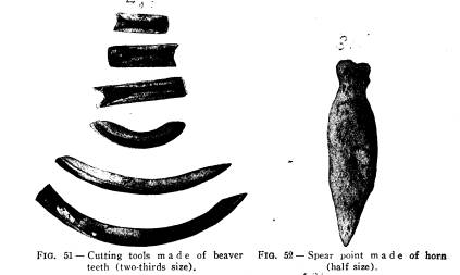
|
because of the great care and patience necessary in the manufacture and because the finished hook in many ways is the ex- act counterpart of our modern hook, devoid of the barb. See Fig. 54. Baum Village, in com- parison with other vil- lages in Ohio, is very rich in fishhooks, broken and perfect hooks being found in every section, some large, being over two and one-half inches in length, while some were quite small, not ex- ceeding one inch in length. Beside the per- fect hooks, every stage in the manufacture of |
|
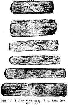
|
Explorations of the Baum Prehistoric Village Site. 107 the hook was also found. This is valuable because of the com- parisons that can be made with those found in other places in Ohio. Referring to Fig. 55, we find No. 1 representing three perfect specimens of fish-hooks made from the tibiotarsus of the Wild Turkey, and many of the unfinished specimens show that this bone was used. All three hooks have been carefully made and two are highly polished, and all have straight and rounded shanks. Two of the hooks have grooves cut in the upper part of the shank, and the third has the shank enlarged at the upper end. All of the hooks have sharp points, and owing to the curvature of the bone, which shows the marrow cavity, the |
|
|
|
points are not in the same plane as the shank. No. 1 was taken from a refuse heap and Nos. 2 and 3 from the refuse pits. No. 2 of Fig. 55 shows three specimens made of bone entirely dif- ferent from that in No. 1. On one side of the hook the spongy character of the rib bone has not been entirely cut away, as shown plainly in No. 3, and the bone from which all three are made is presumably the rib of the deer. No. 1 has a very long shank in proportion to the size of the hook. The upper part of the shank has a crease cut entirely around for attach- ment. No. 2 is the smallest hook found in the village. No. 3 is quite a large hook and well wrought, but shows the cellular structure of the bone from which it was made. No. 3 of Fig. 55 |
|
108 Ohio Arch. and Hist. Society Publications. |
|
|

Explorations of the Baum Prehistoric
Village Site. 109
shows three hooks. Nos. 1 and 2
represent masterpieces in the
art of fish-hook making. No. 1 has a
perfectly fresh appear-
ance, is of fine workmanship and well
polished. The shank
is flat with well-rounded edges and a
perfectly cut groove for
the attachment of the line. The curve of
the hook is symmetrical
and the point is very sharp. No. 2 is
another well-wrought
specimen and perhaps excels in general
workmanship any of the
hooks found in the village. It has a
round shank and a well-
cut groove in the upper end; the point
of the hook is sharp and
nicely polished. No. 3 is quite a large
hook with a slim, round
shank, enlarged at the upper end. The
point of this hook is
not in the same plane with the shank,
owing to the curvature
of the bone. No. 4 of Fig. 55 shows
three finely-wrought hooks.
No. 1 has a round shank with an enlarged
end and the point,
which is gracefully curved and finely
polished, does not extend
parallel to the shank, as in the
majority of hooks found in the
village. No. 2 is similar to No.
1 in general outline, differing
only in being made stronger. No. 3 has a
very slender shank
with an enlarged top, and differs from 1
and 2 in
having the
point parallel with the shank. All three
hooks were found in
the refuse pits. Beside the masterpieces
in the art of fish-hook
making found in the village, specimens
showing the various stages
in the manufacture of the implement were
found, and it seems
that the ancient artificer had in mind a
well defined plan and
proceeded to work it out in bone to the
best advantage. No.
5 of Fig. 55 shows two specimens
illustrating certain stages in
the making of the fish-hook. No. 1 shows
a shank almost com-
plete with an enlarged top, but the base
and point show but
little work. In No. 2 the base has
been practically finished
and the cutting away of the bone forming
the shank and point
begun. No. 6 of Fig. 55 shows two
specimens representing the
very early stages in the manufacture.
The two bones are cut
the desired length and made ready to
remove the center. When
this is done the bone will have the
appearance of one in No. 7
of Fig. 55 and is ready to be cut into
two parts and made into
hooks. This could be done by cutting one
side for the point
which would be nearer one end, and then
cutting the other side
in a similar manner, thus producing two
hooks instead of one.
110
Ohio Arch. and Hist. Society Publications.
No. 2
also shows that the maker had in view the
same object
as shown in No. 1, but had not so nearly
completed the work.
Throughout the village various portions
of fish-hooks were
found, such as points, bases and shanks,
and in No. 8 of Fig. 55
a number of these pieces are shown.
Fully ninety-five per cent.
of the hooks are broken at the curve
between the point and the
shank.
Fish-hooks found at the Gartner Village
site* were similar
in every respect to those found at the
Baum Village, even to
the details of their manufacture, while
at Madisonville, Prof.
Putnam found that the aboroginal
fish-hook makers proceeded to
make their hooks in a very different
manner - by first boring a
hole through the bone, and the hole was
the beginning of the
inside of the curve of the hook. The
point and shank were
worked out from this hole. Prof. Putnam
has described the
stages of fish-hook manufacture at
Madisonville in an article
on "The Way Fish-hooks Were Made in
the Little Miami Val-
ley," which appears in the
Twentieth Annual Report of the Trus-
tees of the Peabody Museum. In no
instance have I found at
the Baum Village Site any bone intended
to be fashioned into
a fish-hook that had been perforated by
drilling. In the article
referred to, Prof. Putnam also describes
two perfect fish-hooks
and one in the process of manufacture,
which were taken from
an ancient burial place along the Little
Miami River by Dr.
Metz, which differ from those found in
the ash pits at Madison-
ville, but agree in every respect with
those from the Baum Vil-
lage Site.
Shell Spoons- Spoons made of the mussel shells are fre-
quently found in the refuse pits, but
the graves furnish three-
fourths of all found in the village.
Very often a large amount
of work in shaping the shell to the
proper proportions is re-
quired, while in others very little work
is needed. Fig. 56 is a
good illustration of the average spoon.
Spoons-- Spoons made from the carapace of the common box
turtle - Terrapene Carolina - are found
in all sections of the
village. Fig. 57 is a very good
illustration of the turtle-shell
* Fishhooks described Vol. XIII, Gartner
Md. & Village Site, Pub.
of the 0. S. A. & H. Society.
|
Explorations of the Baum Prehistoric Village Site. 111
spoon, though many of them have but little work upon them, but where they were in constant use the carapace was cut and trimmed entirely around the edges. They were also found in the graves, but the majority of the turtle-shell spoons found in the refuse pits were broken. Woven Fabrics - Evidences of woven fabrics were found in the refuse pits where the cloth had been charred. Associated with the cloth was corn, beans and nuts of various kinds, and perhaps the woven fabric at one time served as a container for the care of the agricultural products until needed for use. The bags may have been used for carrying and collecting stores of various kinds. No |
|
|
fabrics were found in the graves, as all the dead were buried in the usual way of placing the body at full length in the grave, and no fire was used in connec- tion with the burial ceremony. Consequently, if a woven fabric was used for clothing, and this clothing placed with the dead, not a single thread or imprint of the cloth remained. Ornaments - In the begin- ning of our study of the primi- tive ornaments secured at the Baum Village site, both in the burials and those found scattered in the tepee sites and the refuse pits, I at once saw the similarity of the primitive forms to those of civilized forms. Our pen- |
|
dants, necklaces, bracelets and mounted pearls -all these forms were found in abundance in the village, and the difference lies not so much in the form as in the material and the workman- ship. However, a primitives pearl necklace taken from one of the graves would differ but little from a modern pearl neck- lace, and that only in the matter of selection of the pearls. The drilling, the manner of mounting and the wearing were identical |
|
112 Ohio Arch. and Hist. Society Publications.
with those of to-day. At the Gartner Mound* a gorget was found with a hole cut in the center and a pearl cut and mounted to properly fill it. The ornaments for the most part were made of shell, bone and stone, and were abundant in the refuse pits and burials. Out of the one hundred and twenty-seven burials unearthed in the village, only nine were devoid of ornaments of some kind. |
|
|
The ornaments made of shell were of two kinds: those made from the fresh water mussel, so abundant in the streams, and those made from ocean shells, perhaps secured by barter. The fresh water mussel, on ac- count of the size, would only furnish the smaller gorgets and beads, such as are shown in Fig. 58, while the large shell gorgets, as shown in Fig. 59, were made from the body whorl of an ocean shell. The gorgets shown in Fig. 58 are of three kinds: those perforated with one hole, which is placed |
|
at the center of the disk and range in diameter from one-half inch to one inch, the small size being more abundant; those perfor- ated with two holes, which are placed near the edge of the gor- get and about one-fourth inch apart; and those perforated with three holes, one at the center, which is usually the largest of the * Exploration of the Gartner Mound and village site, pub. of the Ohio State Arch. & Hist. Society, vol. XIII. |
|
Explorations of the Baum Prehistoric Village Site. 113
three, and two near the edge about one-fourth inch apart. The central hole is usually quite large in proportion to the holes near the edge, and no doubt was set with pearls and other ob- jects. The large shell gorget, as shown in Fig. 59, was found in the grave of a child about ten years of age, and is the only large gorget found during the entire explorations in the village. Shell Pendants - Pendants made of shell, as shown in Fig. 60, were found in every section of the village, especially in the burials. For the most part they were made of ocean shells, oc- |
|
|
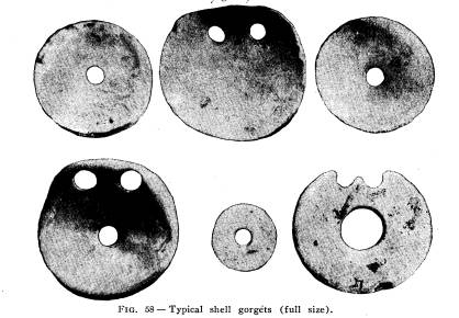
|
casionally one being found made of mussel shell. Those made of ocean shells were usually an irregular strip of shell, unevenly polished, and pierced at one end for attachment, and varied in length from two inches to three and one-half inches. Shell Beads -Beads made of shell were for the most part made of ocean shells, and were of two kinds, those made from the large body whorls of Fulgur perversum, never exceeding one- fourth of an inch in diameter, highly polished and perforated with a hole at the center and representing a high degree of skill Vol. XV -8 |
|
114 Ohio Arch. and Hist. Society Publications.
in their manufacture. The other kind was made from a small ocean shell, Oliva literata, which was slightly altered by cutting away the apex and producing a passage for a string, which may be introduced through the natural aperature. Another small ocean shell, Marginilla conoidalis, was frequently met with, and they were cut and ground in the same way as the Oliva. Pearl Beads - Beads made from the fresh water pearls are frequently met with in the graves. The pearls are all small, usually irregular in shape, and have no doubt lost much in size by exfoliation, as the thin decayed lamellae drops off in concen- tric scales, showing beneath the iridescent nacre. The pearls |
|
|
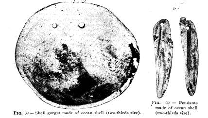
|
were no doubt secured from the fresh water mussels found so abundantly in the river. Bone Beads- Beads made of bone were present in almost all the graves where ornaments were placed, and they were also abundant in the tepee sites and refuse pits. Fig. 61 shows a necklace of bone beads made from the femurs of small animals, and the wing bones of birds. This necklace was found in the grave of an adolescent. Bone beads were made in two ways, by cutting a crease entirely around the bone with a flint and then breaking, and afterward polishing to remove the rough edges. Fully 75 per cent. of the beads are made in this way. Another |
|
Explorations of the Baum Prehistoric Village Site. 115
way of making beads was by the use of fire, perhaps resorted to when flint was not at hand, and was accomplished by burning a ring around the bone at the point desired, and then breaking and afterward grinding off the rough edges. By this process a part of the charred bone remains and takes a high polish, which no doubt added to the ornamental value of the beads. The necklaces found at the Baum Village for the most part con- sisted of a strand of beads, small toward the ends and increas- ing in size toward the middle, where a central bead of unusual size or design is placed. Sometimes this central bead takes the |
|
|
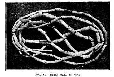
|
form of a pendant, which may be made of bone as shown in Fig. 62, or a perforated canine of the black bear or a large piece of polished shell. Further indications were found in the graves that beads were also used to ornament their hair, and even hung as pendants from the hair. Other burials show that beads were used as bracelets and anklets. Pendants Made of Teeth - Canine teeth of the bear, wolf and elk were invariably used for pendants in necklaces, and quite often formed the entire necklace. Fig. 63 is the canine tooth of the Indian dog, perforated at the base for attachment. Fig. 64 shows three canine teeth perforated at the base for at- |
|
116 Ohio Arch. and Hist. Society Publications.
tachment. The two teeth to the left, an upper and lower canine, are those of the black bear; the one to the right is the canine of the gray wolf. None of the large teeth found in the Vil- lage had any work done upon them other than a hole drilled through the base. Fig. 65 shows the upper carnassial of the |
|
|
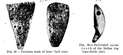
|
gray wolf which was invariably used for pendants. The three roots have a groove cut around them for attachment. No other teeth of this animal were used separately for ornament, but por- tions of the lower jaw with teeth attached were used. |
|
|
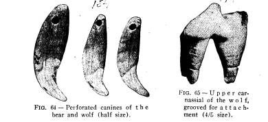
|
The incisor teeth of the elk, as shown in Fig. 66, were highly prized for ornament, and quite often formed the pendant of necklaces found with the burials. The majority of the teeth had a groove cut around the end of the root for attachment. However, quite a number were perforated with a hole for at- |
|
Explorations of the Baum Prehistoric Village Site. 117 tachment. The incisor teeth of the deer, although much like the elk, were not used for ornament. The canine teeth of the elk, as shown in Fig. 67, were always used for ornament. From one grave a necklace composed of nine teeth was found; in another two teeth were found, one on each side of the head of the skeleton, and were presumably used as ear ornaments, while in other instances a single tooth was found in a position to indi- cate its use as a pendant suspended from the neck unassociated with any other ornament. The teeth for the most part had a single hole for attachment, the drilling being done from both sides of the tooth through the base of the root. Occasionally a tooth would be met with having two holes for attachment. Another interesting pendant and found in many burials, was that made from the digits of the wild turkey and other large |
|
|
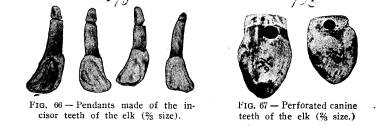
|
birds. They were made by drilling a hole in the posterior end of the digit to the depth of about one-fourth of an inch, and then drilling a hole from the side until a connection was made with the first hole drilled. No other work was done upon them. Pendants made of claws of various animals and birds, such as the bear, wolf, mountain lion and eagle were found sparingly in all parts of the village examined. The majority of the claws were not perforated for attachment, but invariably those of the mountain lion were perforated with one hole. Cut Jaws Used as Ornaments- The cutting into form of animal jaws to be worn as ornament was a very prominent feature in ornament making of the inhabitants of Baum Vil- lage. The upper and lower jaws of the Gray Wolf (Canis oc- cidentalis) were always made into ornaments. Fig. 68 shows a very frequent way of cutting the jaw in the desired form. |
|
118 Ohio Arch. and Hist. Society Publications. The inferior dental canal is entirely cut away, and the ends of the roots of the teeth are also cut away. The incisors and pre- molars are gone, but the canine remains. Another form of cut- ting the jaw is shown in Fig. 69, where two molars and two pre- molars are left. Fig. 70 shows the manner in which the jaw |
|
|
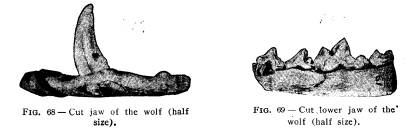
|
was cut. Bear jaws cut into ornaments were not found in the village, though in other sections of the county ornaments made of the jaws of this animal were frequently met with. At the Baum Village nothing but the gray wolf was found. Deer jaws cut into implements or ornaments are not abun- dant in the village, although the perfect and broken jaws are |
|
|
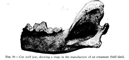
|
present everywhere. Fig. 71 shows a very interesting cut jaw. The posterior part is entirely cut away, and the symphysis is greatly reduced by cutting and afterward polishing. The per- fect set of teeth shows no artificial wear. So far I have not been able to suggest its use. |
|
Explorations of the Baum Prehistoric Village Site. 119 Wild turkey heads perforated with from one to three holes were abundant in the refuse pits, but none were found in the graves. However, at the Gartner Mound, in one of the graves, fourteen heads were found which had served as rattles. The heads were perforated with holes for attachment, and each con- |
|
|
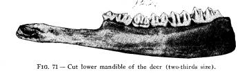
|
tained small quartz pebbles. The heads found at Baum resembled in every way those found at the Gartner Mound. Pipes - Both perfect and broken pipes were found in every section of the village, though not many were found in the graves, Out of one hundred and twenty-seven burials only two had pipes placed in the grave, one had a single pipe as shown in Fig. 72, and the other had two, both made very much alike, one of which |
|
|
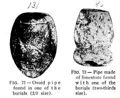
|
is shown in Fig. 73. For the most part, pipes with- out stems were the pre- vailing type found. |
|
|
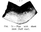
|
A type of pipe with a short stem is shown in Fig. 74, as well as a tubular pipe made of clay, was also found. The tubular pipes were apparently made of the same kind of tern pered clay used in making pottery. The average length was four and one-half inches, and the greatest diameter one inch, |
|
120 Ohio Arch. and Hist. Society Publications.
The tube at the largest end would average almost three-fourths of an inch, gradually tapering to the small end, where it is about one-fourth inch or less in diameter. The egg-shaped or oval forms were more abundant than any other form. They were made of limestone, quartzite, slate and sandstone. Pipes showing all the stages of manufacture were found from the roughly pecked form to the polished quartzite with the hole in the bowl half completed. Method of Burial in the Village - The manner of burying |
|
|
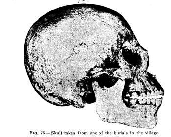
|
the dead, as shown in Fig. 6, may be considered as the typical method at the Baum Village. Each family group had their own private burial ground, and it was very close to the tepee. In several instances the graves were less than three feet from the tepee site and seldom would the graves be more than ten feet away. In close proximity to the mound the family groups were quite near each other, and the family burial ground so restricted that the dead would necessarily be buried close together, and the subterranean storehouses would be dug near the burial grounds. This condition is shown in Fig. 76, where three chil- |
|
|

|
121 |
|
122 Ohio Arch. and Hist. Society Publications.
dren and four adults were exposed and photographed together with one of the largest storehouses found in the village. Three more children were found to the right of those shown in the photograph, making ten in this family group, four adults and six children. The tepee site was to the left of the burials and so close that the head of the adult to the left was very much less than three feet from the post molds which show the outline of the tepee. While no pottery was placed in the graves of this group, the fragments show perhaps the most elaborate dec- orations and the remains of the largest vessel found in the vil- lage. The subterranean storehouses were also unusually large and the contents were very rich in animal remains and imple- |
|
|
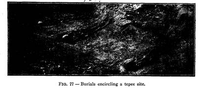
|
ments and ornaments of various kinds. In another group the burials were in a circle around two sides of the tepee. Three of these burials are shown in Fig. 77, while two more to the right constitute the family group. For the most part the bodies were placed in the grave with a perishable covering, though three graves were exhumed which were covered with slabs of slate. The covered graves pertained to three different families, and each was in close proximity to other graves. Fig. 78 shows a covered grave of an adolescent; on the left is an adult and between the two is the skeleton of a very small child. The adolescent's grave, as is shown by the photograph, was carefully covered with the slabs of slate, showing more than ordinary care for the dead. The three covered graves contained two adoles- |
|
Explorations of the Baum Prehistoric Village Site. 123 |
|
|

|
124 Ohio Arch. and Hist. Society Publications.
cents, and one child. Another form of burial occasionally met with in the family groups was where the interment was made in one of the abandoned storehouses. A photograph of this mode of burial is shown in Fig. 79. The head is bent backward and the legs are flexed so that the feet are very near the pelvis, and the whole body made to conform to the size of the pit. During the entire exploration only four skeletons were taken from the bottom of refuse pits, showing that perhaps the burials were |
|
|
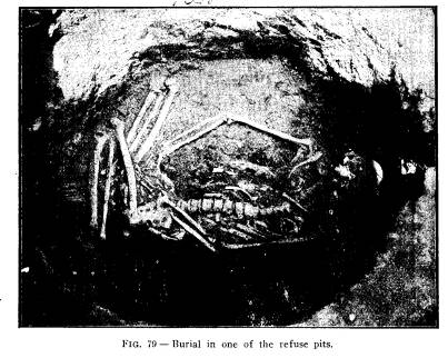
|
emergency burials, the death occurring during the winter when the ground was frozen, making it a very difficult task to excavate the frozen earth with the primitive digging implements. How- ever, the pit burials may have only been temporary burials, and the re-interment would take place when conditions were favor- able for making the proper excavations. In two of the burials in the pits the indications point to a permanent burial after the bodies had been placed in the pits, which were quite deep. The clay forming the sides of the pit was used to cover the body to |
|
Explorations of the Baum Prehistoric Village Site. 125
the depth of four inches, and afterwards the pit was filled with refuse the same as other pits in the village. The other two burials had been placed in the pits after they had been about one-fourth filled with refuse, and the bodies were covered with ashes to the depth of three inches, and the pits afterwards filled with refuse. These two may have been temporary burials and left by accident in the pits. The inhabitants of Baum Village, according to the measure- ments, would average for adult males about five feet seven and one-half inches in height and adult females five feet four inches, only one man being found that would measure six feet. His skeleton as shown in Fig. 80. The bones of the skeleton are perfect, and are large in proportion to the height of the indi- vidual. He died before reaching the age of thirty years. Sev- |
|
|
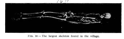
|
eral skeletons of adult males found in the village have strong, heavy and perfect bones and prominent muscular attachment, in- dicating that they were strong and muscular, and lived to a ripe old age. A photograph of one of these skeletons, which measures five feet six and three-quarter inches in height, is shown in Fig. 81. Out of forty-nine tepee sites explored, ten had no burials surrounding them, and only a few storehouses, showing that the tepee had not been occupied for any great period. All the burials in the entire village were practically the same, being placed in a grave with their implements and ornaments, unat- tended by any ceremony of fire. As I have stated elsewhere in this paper, fifty-eight per cent. of the children never reached the adult age. I also made an estimate from my field notes of the fifty-three adults and find |
|
126 Ohio Arch. and Hist. Society Publications.
that ninety-two per cent. died before reaching the age of fifty, and that fifty-six per cent. died before reaching the age of thirty. I also found that twenty-one skeletons of the one hundred and twenty-seven exhumed had diseased bones, and I requested Mr. S. T. Orton, then a student at the Ohio State University pre- paratory to his course in medicine and one of my assistants in the field, to take up the study of the diseased bones when the proper time came. Accordingly, after finishing his scientific course at the Ohio State University, he entered the Medical Department of the University of Pennsylvania and devoted much of his spare time for three years to the microscopical study of the diseased bones procured from the graves of the Baum Vil- |
|
|
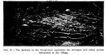
|
lage Site, and in April, 1905, published in the Medical Bulletin of the University of Pennsylvania the results of his investiga- tion in a paper entitled "A Study of the Pathological Changes in Some Mound-Builders Bones from the Ohio Valley, With Especial Reference to Syphilis," and I quote at some length from this article. "As will be seen below the lesions of the bones examined are such as to lead to the diagnosis of syphilis as their etio- logical factor. The reader of works on the history of syphilis will find interest in the discussions of many syphilographers and historians on the origin of this now almost universal dis- ease. The French writers especially have taken up the argu- |
|
|

|
127 |
|
128 Ohio Arch. and Hist. Society Publications.
ment, and we find opinion divided between three possibilities: (1) That the disease was endemic both in this continent and the old world before communication was established across the Atlantic. (2) That the origin of the infection was in the Ameri- can races, and that it was carried to Europe by the sailors of Co- lumbus' expedition on their return; and (3) the reverse of the |
|
|
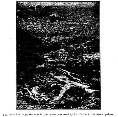
|
latter theory - i. e., that its place of endemicity was in Europe, and that it was brought westward to this side of the Atlantic by Columbus' men and so implanted here. It will be readily seen that the results of the present inves- tigation have no bearing on the two former hypotheses. If the diagnosis given is correct, in view of the undoubted pre-Colum- |
Explorations of the Baum Prehistoric
Village Site. 129
bian time of these remains, it is
entirely incompatible with the
third explanation. It may well be added
here, however, that
the supporters of this theory are
comparatively few.
A vast amount of literature has been
published in discus-
sion of this question, and strong
arguments brought to bear on
all sides.
The work of Buret in support of the
universal pre-Colum-
bian distribution brings up some very
strong proofs. These
volumes, while of only a semi-scientific
nature, gives a resume
of a great amount of evidence of various
worth. Early in the
first volume is an account of lesions
found on human osseus
remains exhumed at Soultre in the
Department of Saone-et-
Loire in western France. These bones,
found buried with those
of the horse and reindeer and cut
flints, etc., belonging to the
Gallo-Roman or Merovingian epochs, were
referred by anthro-
pologists of the best authority to the
Stone age, and, the author
adds, "examined by Broca, Ollier,
Parrot, and Virchow, the le-
sions were, by common consent,
pronounced syphilitic." Then
follow reports of examinations of
several Peruvian prehistoric
skulls showing evidences of acquired and
hereditary syphilis and,
by way of contrast, lesions which from
their description seem
identical, on bony remains from the
caverns and dolmens inhab-
ited by "tribes who peopled the
Gauls during the Stone Age and
in the druidical times before the
Frankish dynasties." In another
chapter is given an abstract of
translations from Chinese doc-
uments collected by the Emperor
Hoang-ty, 2637 B. C., and form-
ing the volume Hoang-ty-mi-King or the Medical
Treatise of
Hoang-ty. Quotations of this translation give very apt descrip-
tions of the two main varieties of
venereal ulcers with reference
to the connection between the Hunterian
sore and the secondary
eruption, with an account of the
varieties of the latter which is
easily recognizable, and as treatment
advise mercurial frictions,
aided by an oily mixture and a powder
composed of mercury.*
* It is of interest here to mention also
the account of vaccination
against variola practised by the Hindoo
physicians 1000 years B. C., by
taking the liquid of the pustule of the
cow's teat or from the arm of
a human being, placing it upon the point
of a lancet and introducing
it into the arm of the patient to be
vaccinated, mixing the fluid with
the blood, etc.
Vol. XV - 9
130 Ohio Arch. and Hist. Society Publications.
In support of the existence of syphilis
in Biblical times, during
the ascendancy of the Greeks and Romans
and in the Middle
Ages, is quoted a mass of documents,
largely secular, which show
beyond doubt that venereal diseases of
some kind were rampant
then, and would seem to indicate the
probability of the existence
of lues venerea, but hardly prove the
point.
On the other side the discussion was
headed by Astruc,
the early French syphilographer. His
articles, while able, were
written before the discovery of many
important pieces of evidence,
and hence are not of such worth as the
work of Bloch, which is
among the most recent writing on the
subject.
Bloch credits the appearance of the
disease in Europe to
the return of Columbus' first expedition
and its rapid dissem-
ination to the debauchery of the troops
of Henry the VIII. of
France on his expedition against Naples
and their widespread
dispersion, carrying the infection with
them, at the end of the
siege. He uses the malignency of the
epidemic of Naples as
an argument in support of his theory
that European peoples
were before that outbreak free from the
disease and consequently
lacked that immunity which would obtain
through long exposure
of the race to infection. To quote
directly: "Wenn der Syphilis
schon Jahrtausende bestanden hatte, dann
hatte doch im Laufe
dieser langen Zeit ein so grosse
Immunisirung der Volker des
Orbis antiquus gegen das syphilitische
Gift eintreten mussen dass
die Ereignisse am Ende das funfzehnten
Jahrhunderts einfach un-
moglich gewesen waren.
He asks how else can the early
appearance of the secondary
lesions, the high fever, the pain, the
high mortality, etc., in
the Neapolitan outbreak be explained. It
seems not untenable
to believe that the infection had been
present on both sides of
the Atlantic for thousands of years and
that in this way the
virus may have become attenuated in each
continent - so much
so in Europe as to have been overlooked
during the dark era
of the Middle Ages, or to have been
confounded with leprosy
or other current diseases-and to have
owed its virulence in
the epidemic of 1495-6 to a
transplantation of the infection of
American origin on to what might be for
it a favorable soil.
Evidences of this variability in
infective agencies is seen some-
Explorations of the Baum Prehistoric
Village Site. 131
times in cases where inhabitants of a
notorious typhoid centre
remain free from infection for indefinite periods only to
suc-
cumb to the disease on removal to
another endemic focus. Here
also may be mentioned the severity of
the venereal infections
brought back by our own troops from the
Philippines. One
author has spoken of the organism of
gonorrhoeal infection from
this source as the micrococcus
gonorrhoeae malignus.
With regard to the pathology of the
specimens under exam-
ination a considerable handicap is
apparent in that the cellular con-
stituents of the bones are long since
disintegrated, but the lesions
of the resistant parts are sufficiently
characteristic to permit of
diagnosis. These changes in the hard
parts in syphilitic diseases
exclusive of the cellular study are
reviewed here for comparison
with the results to be shown presently.
All authors agree on the subject that
the bones most fre-
quently the seat of syphilitic changes
are those which are most
exposed to trauma, which seems to act as
a focalizing factor for
the morbid process. The order of
preference given is: the tibia,
clavicle, cranium, ulna, sternum, ribs,
etc. This is notoriously
the distribution of lesions found in the
mound-builders. One
particular skeleton is recalled in which
the gross changes were
apparent in both tibiae, the vault of
the cranium, one clavicle,
and one ulna, and this was noted before
the sites of election of
the syphilitic processes were known to
the observer, and, in-
deed, before syphilis was suspected as
being a factor in the
case. The following figures, furnished
by Mr. Mills, will show
something of the distribution: Of one
hundred and twenty-seven
skeletons exhumed at the Baum Village
site, twenty-one were
diseased. Fully sixty per cent. of those
affected show the lesions
worst upon the tibia, the ulna coming
next perhaps, then the
cranium and then the sternum. But few
ribs were affected.
"The gross changes brought about by
the syphilitic process
in long bones consist of one or more
large exotoses (rarely a
hyperostosis) in the diaphysis. In the
tibia, for instance, the
exotosis is usually single when well
advanced and is a large,
ovoid hypertrophy, most frequently in
the upper half of the shaft,
although sometimes the whole of the
diaphysis is involved. This
new growth of bone, to be typical, shows
both in the gross sec-
132 Ohio Arch. and Hist.
Society Publications.
tion and microscopically the condition
of rarefying osteitis side
by side with one of condensing osteitis
which may be far enough
advanced to justify the term
'eburnation.' In any given speci-
men, however, the lesions may be chiefly
confined to any one of
these three types, dependent on the
progress of the disease-
but the other types are always present
to a greater or less de-
gree. There may be also on the surface
of the bone small osteo-
phytes either of intense hardness when
they are, as a rule, more
or less regular and polished, or when
they occur in the line of
origin or insertion of a muscle
roughened, irregular projections.
"Sometimes the exostosis, which is
nearly always on the
anterior aspect of the bone (that part
exposed to trauma), may
involve the entire length of the
diaphysis, giving a curve of
large radius with convexity forward and
distorting the whole
of the bone except the epiphyses, which
seem to be entirely nor-
mal. This gives rise to the condition
called 'sabre-blade' de-
formity when occurring in the tibia,
where it is most frequently
seen. The lumen of the medullary canal
may be enlarged through
absorption of the bone surrounding it.
This may be greater or
less than, or equal to, the deposition
of bone from the periosteal
side, thus giving a large canal with
thin walls or thick walls
with an increased lumen, or an increased
lumen with walls of
about normal thickness. Sometimes deposition of bone takes
place from the endosteum, encroaching on
the medullary canal
either through the formation of dense
bone or through a mesh
of very fine interlacing spicules of
osseous material, almost or
entirely filling up the original canal.
The external surface of an
exostosis of a long bone may be as
smooth as, or even smoother
than, the normal bone surface, in which
case the condition of
sclerosis will usually be found to be
the predominant one, or it
may be marked with irregular lines or
depressions more or less
parallel with the long diameter of the
shaft, or deeply grooved
with branching channels in which lay the
enlarged periosteal ves-
sels, or filled with small holes running
into the body, which on
section prove to be enlarged Haversian
canals perpendicular to
the shaft.
"Differential diagnosis is here
made from tuberculosis,
chronic osteomyelitis, and osteitis
deformans. The pathological
Explorations of the Baum Prehistoric
Village Site. 133
changes of bone syphilis are so clear
and well defined, however,
as not to require elaborate
differentiation. Osteitis deformans,
while a rare disease, now, is included
in view of the fact that so
little is known of the diseases
prevalent at the time from which
our material has come. In the osseous
lesions of tuberculosis
and chronic osteomyelitis the formation
of an involucrum with
sequestra and claocae is usually a
prominent feature. In the
tuberculous bone affections the disease
is very often manifested
in the epiphyses and joints and leaves
there unmistakable traces
of its ravages. Lazarus-Barlow is quoted
here: 'Tuberculous
disease of bones differs in the fact
that sclerosis is almost char-
acterized by its absence. * *
* It is never found that a
focus of tuberculous disease shows a
considerable formation of
new bone in the neighborhood of the
principal seat of the dis-
ease. The utmost that we see is the
presence of a few osteophytic
growths. Again, the same author says of
osteitis deformans:
'All bones are usually affected and the
whole bone is involved.'
This is a true hyperostosis of general
distribution rather than
exostosis on certain selected bones as
is the case in syphilis.
"The microscopic picture of bone
syphilis exclusive of the
cellular changes is directly comparable
to the gross lesions -
i. e., concurrent rarefying and condensing osteitis. Cornil
and
Ranvier, in describing the result of
rarefaction by enlargement
of the Haversian canals, says: ' *
* * The canals commun-
icate and by their junction form
irregular spaces filled with
marrow of an embryonal type.' Simes and
White, in their trans-
lations of Cornil's Syphilis, describe
the sclerotic changes as fol-
lows: 'When under the influence of
appropriate treatment or fol-
lowing the natural course of the malady,
the inflammation ceases
and the disease retrogrades, there is
seen a reparation of the
diseased and partially destroyed bone. *
* * There result new
lamellae with new osteoblasts, and these
form several series par-
allel one with another, or follow the
irregular arrangement of
the Haversian canals. This exuberant
formation of new osseous
lamellae may constitute beneath the
periosteum exostoses of vary-
ing size and in the bone a
parenchymatous exostosis or eburna-
tion." Again in Shakespeare and
Simes' translation of Cornil
and Ranvier's work appears the
following: 'A transformation
134
Ohio Arch. and Hist. Society Publications.
which has taken place in consequence of
the formation of osseous:
tissue which being deposited in the
interior of the canals has
narrowed them. The new osseous layers
may be so arranged
that the lumen of the canal does not
correspond to the centre of
the original canal. This process
continuing, the canal may be
completely obliterated, so that at the
centre of the concentric
layers, instead of a canal there is
found one or more bone cor-
puscles.'
"A rough qualitative analysis of
the material under exam-
ination showed large amounts of calcium
and magnesium, some
aluminum, a trace of iron, the carbonic,
sulphuric, and hydro-
chloric acid radicals, and considerable
organic matter. On com-
plete incineration of a portion of bone
in the oxidizing flame,
reducing it to an amorphous white
powder, a loss of seventeen
per cent. by weight was noted. After
heating until the mass
charred and then lost its black color
(becoming gray and not
white as above, and leaving no residue
on solution with dilute
hydrochloric acid) the percentage of
weight loss was on an average
ten. Although the conclusions here are
reached by a very rough
method and are probably far from
accurate, ten per cent. weight
loss is taken to represent approximately
the amount of organic
matter and the additional seven per
cent. accounted for by the
breaking up of the carbonates and the
evolution of carbon dioxide.
The source of the organic matter here is
a question - whether
remains of the original animal matter of
the bone, or vegetable re-
placement during their stay in the soil.
The latter possibility seems
more reasonable and is supported by the
finding of small roots
in the medullary cavity of some of the
bones sending their
finer branches into the cancellous
structure and enlarged Haver-
sian canals.
"RESUME-The material under
examination is from a
source undoubtedly pre-Columbian and the
lesions are such as
to justify the diagnosis of syphilis by
the following pathological
evidence: Changes affecting chiefly the
diaphyses where long
bones are concerned, showing a
predilection for those bones which
are most exposed to trauma, consisting
of large exotoses and
osteophytic overgrowths, and
characterized by the concurrent
presence in the same specimen of both a
rarefying and con-
Explorations of the Baum Prehistoric
Village Site. 135
densing osteitis as demonstrated by
gross and microscopic ex-
amination. Of one hundred and
twenty-seven skeletons from one
series of excavations, twenty-one showed
traces of disease, sixty
per cent. of the affected showed the
changes most upon the tibia
with the ulna, cranium, and sternum
following in order. Of the
specimens examined rarefying osteitis
was grossly manifest in
all but two, one of which (ankylosed
metatarsal and cuneiform)
was probably of traumatic or septic
nature, and the other (a
clavicle) was not examined in
cross-section. Grossly sclerosis
was evident in three of the ten, while
on microscopic examina-
tion only one of six from which sections
were taken failed to
show condensation in some areas."
The explorations of the Baum Village
site have brought to
light many points of interest concerning
the home life of a
prehistoric people who had risen above
the level of mere chil-
dren of the forest, depending upon wild
wood for their subsis-
tence.
They had established homes, a developed agriculture,
made the collection of and provided
storage for food supplies
for future use. Therefore the Baum
Village site culture in all
essential points resembles the culture
of the Gartner Village site
along the Scioto, and the Ft. Ancient
and other culture sites
along the Miami; establishing the fact
that at one time the val-
leys of southern and central Ohio were
peopled by a culture
which was quite uniform throughout the
entire section, and for
convenience I have termed these early
inhabitants the Ft. Ancient
Culture. The manufacture of their
implements, such as scrapers,
awls, needles and fish-hooks, as well as
the many implements
in stone, as shown by the various stages
in the manufacture of
these implements, were in every respect
similar throughout the
entire region. In the manufacture of
their pottery, and especially
in regard to their designs and shapes,
they were quite similar,
and it would be impossible to
distinguish the Ft. Ancient pottery
from the Baum, and the Baum from the
Gartner Village Site
pottery. In the same valleys occupied by
the Ft. Ancient Cul-
ture we find evidence of a higher
culture, and for my con-
venience I have designated this culture
the Hopewell Culture,
taking the articles secured by Prof.
Moorehead from the Hope-
well Mounds as the type. The Ft. Ancient
culture occupied
|
136 Ohio Arch. and Hist. Society Publications.
portions of the valleys which were later occupied by the Hope- well culture, as was evidenced by the results of the explorations of the Harness Mound group during the past summer (1905). After completing the explorations of the Harness Mound, the articles taken therefrom being of the higher culture, I exam- ined a mound located outside of the great circle and not far distant from the Harness Group, directly to the south, and found this mound to be a burial mound of the Ft. Ancient Culture. At the center of the mound, and a few feet under the surface, was found an intrusive cremated burial, similar in every respect to the cremated burials of the Harness Mound. The artifacts of the Hopewell Culture can in almost every object used in com- mon by the two cultures readily be distinguished from those of the Ft. Ancient Culture by the portrayal of the esthetic ideas of the artisan. My conclusions are, as I have stated elsewhere in this paper, that the builders of the Baum Mound were isochronological with the dwellers in the Baum Village. As in all the sites of the Ft. Ancient Culture examined, the inhabitants had an inter-tribal trade, as evidenced by the copper, ocean shells and mica there found; that the dwellers in this village were pre-Columbian, as no objects showing European contact were met with and the village was occupied by the same culture in all its parts. |
|
|
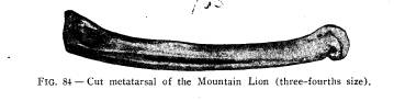
BAUM PREHISTORIC
VILLAGE.
WILLIAM C. MILLS.
The Baum Prehistoric Village site is
situated in Twin Town-
ship, Ross County, Ohio, just across the
river from the small
borough of Bourneville, upon the first
gravel terrace of Paint
Creek.
The Paint Creek valley is drained by
Paint Creek, a stream
of irregular turbulence, flowing in a
northeasterly direction, and
emptying into the Scioto River, south of
Chillicothe. The Valley,
at the site of this village upwards of
two miles in width, is sur-
rounded on the east and west by high
hills which are the land-
marks of nature, but little changed
since the days of the pre-
historic inhabitants.
Spruce Hill, Fig. I, with steep slope
covered with a dense
forest, towers above the surrounding
hills on either side. The
top of this hill is made a veritable
fortress by an artificially con-
structed stone wall, enclosing more than
one hundred acres of
land. This fortress would no doubt
furnish a place of refuge to
those who might be driven from the
extensive fortifications in the
valley below, which are in close
proximity to the mounds and
village of those early people.
Looking to the south and east from the
village site, one can
see lofty hills rising in successive
terraces, no longer covered
with the deep tangled forest, but
transformed by the woodman's
axe, and now under cultivation,
producing the golden corn, which
is our inheritance from primitive man
who inhabited the Valley
of Paint Creek many centuries ago.
The village extends over ten acres or
more of ground, which
has been under cultivation for about
three-quarters of a century.
Almost in the center of this village,
near the edge of the terrace
to the west, is located a large square
mound. This mound and
the earthworks which are directly east
of it, have been known
since early times as the landmarks of
the early settlers in this
section of Ross county. The mound was
first described by Squier
45
(614) 297-2300