Ohio History Journal
- 1
- 2
- 3
- 4
- 5
- 6
- 7
- 8
- 9
- 10
- 11
- 12
- 13
- 14
- 15
- 16
- 17
- 18
- 19
- 20
- 21
- 22
- 23
- 24
FORT ST. CLAIR
CELEBRATION OF ST. CLAIR DAY
No history of the Northwest Territory
would be
complete without conspicuous reference
to what is now
Preble County, Ohio. Through its
primeval forests
General Arthur St. Clair, in the autumn
of 1791,
marched on his ill-fated expedition to
disastrous defeat
by the Indians near the present site of
Fort Recovery,
to return later in disorderly retreat.
Over the same
route General Anthony Wayne advanced
with his
legions, by careful stages, in October,
1793, to a signal
victory at the battle of Fallen
Timbers, in what is now
Lucas County, August 20, 1794. This
battle prepared
the way for the Treaty of Greenville,
August 3, 1795,
and the suspension of Indian incursions
until the cam-
paign of General William Henry Harrison
in 1811,
which culminated in the battle of
Tippecanoe.
The defeat of St. Clair left the
western border open
to the attacks of the Indians and
greatly retarded for
a time the settlement of the Ohio
Country. To afford
a measure of protection and stay the
advance of the
savage foe, Fort St. Clair was erected
between Fort
Hamilton and Fort Jefferson, on a site
about one mile
from the public square of Eaton.
The history of this fort, as detailed
in an address on
St. Clair Day, is presented on
following pages and need
not be repeated here. The accounts of
the battle that
was fought almost under the guns of the
fort are prac-
tically all based on a letter written
by Judge Joel Col-
(506)
Fort St. Clair 507
lins, of Oxford, who participated in
that historic event
and the official report of Major John
Adair in command
of a detachment of militia from
Kentucky and after-
wards governor of that state.
Between Eaton and the site of Fort St.
Clair is the
cemetery in which at last rest the
remains of Lieutenant
John Lowry and Ensign Samuel Boyd who
fell in an
engagement with the Indians at Forty
Foot Pitch,
October 17, 1793. On succeeding pages
is presented a
discussion of the location of Forty
Foot Pitch, which
seems to have been involved in
considerable doubt.
In the very first issue of the Centinel
of the North-
western Territory, the first newspaper published in the
Ohio country north of the Ohio River,
bearing date of
November 9, 1793, appears an account of
this engage-
ment which is a paraphrase of the
official report of
General Wayne. It reads in part as
follows:
Many reports having been circulated with
respect to the
attack made by the savages upon a convoy
of provisions, some
little time ago, between Fort St. Clair
and Fort Jefferson, the
following is an authentic account of the
affair.
Lieutenant Lowry, of the Second, and
Ensign Boyd of the
First sub-legions, with a command
consisting of about ninety
non-commissioned officers and privates,
having under their con-
voy twenty wagons loaded with grain and
commissary stores,
were attacked between day-light and
sunrise, seven miles ad-
vanced of Fort St. Clair, on the morning
of the 17th ult. These
two gallant young gentlemen, with
thirteen non-commissioned
officers and privates, bravely fell in
action. * * * The Indians
killed or carried off about seventy
horses. * * *
The officers who fell in this action
belonged to the
regular army and their names together
with a brief
record of their services, are preserved
in the archives
of the Republic. The sketches are as
follows:
508
Ohio Arch. and Hist. Society Publications
John Lowry. From New Jersey; lieutenant
in the levies of
1791; ensign 2nd Infantry, April 11, 1792; 2nd
sub-legion, Sep-
tember 4, 1792; lieutenant February 20, 1793; killed
October 17,
1793, in action with Indians near Fort
St. Clair, Ohio.
Samuel Boyd. From Pennsylvania;
surgeon's mate; Ist
sub-legion, February 23, 1793; ensign
1st sub-legion, March 3,
1793; killed, October 17, 1793, in
action with Indians near Fort
St. Clair, Ohio.
The remains of these officers and the
men who fell
in action with them were first buried
near Fort St. Clair
and afterward reinterred in the
cemetery.
Following are the names of the
non-commissioned
officers who were lost in this action:
Warren Murray,
Sergeant; Ezekiel Morrill, Sergeant;
Silas Burret,
Corporal.
The names of the privates were as
follows: Nicholas
Brooks, Elisha Barrows, Calvin Brown,
John Connor,
Henry Derris, Enos Hall, Lewis May,
John Phillips,
Joshua Risley, Thaxter York.
Murray, Derris, May, Phillips and York
are desig-
nated as "missing".
The foregoing names are in the report
made to the
War Department and are here printed, it
is believed, for
the first time. Captain Daniel Tilton
of the 2nd sub-
legion commanded in this action.
The Preble County Historical Society
which has
been active in recent years in arousing
interest in local
history planned and carried out most
successfully a
celebration of St. Clair Day, November
6, 1922, the one
hundred and thirtieth anniversary of
the battle with
the Indians near Fort St. Clair. The
program rendered
on that occasion follows:
Fort St. Clair 509
THE FIRST ANNUAL HISTORICAL
ST. CLAIR DAY
NOVEMBER 6, 1792-1922
Originated by
PREBLE COUNTY HISTORICAL SOCIETY
PROGRAM
12:15-1:30
at the Old Fort. Flag Salute -- (21 guns) C. M.
Wilcox, New Paris, Ohio.
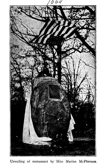
Unveiling of Monument -- Marion McPherson, Eldorado.
Remarks -- C. B. Galbreath
of the State Historical and Archaeo-
logical Society, Columbus, Ohio.
Music -- Girls' Sextette -- Union High School,
Lewisburg, Ohio.
1:30 P. M. Assembly Room of Court House
Music -- Girls' Sextette -- Union High
School.
The Story of Fort St. Clair -- Ralph
Ehler, West Alexandria
High School.
Lost Treasures -- (Columbus meeting the
Indians) -- Pupils of
Jefferson Township High School.
The Birth of the Flag -- Pupils of
Jackson Township Schools.
Chorus -- The Star Spangled Banner.
Address-- C. B. Galbreath, Columbus,
Ohio.
Vocal Solo -- Oleson Zimmerman, Gratis
High School.
Lowry's Skirmish at Ludlow's Spring --
Monroe Township High
School.
Music -- Quartette -- Monroe Township High
School.
Evening 7:30 P. M. Assembly Room Court House
Music -- Pupils of Jefferson Township
Schools.
Surrender of Indians at Greenville --
Pupils of Dixon Township
Schools.
Legends of Early Preble County History
-- Frank Blackford,
Eldorado, Ohio.
Mad Anthony Wayne in Preble County --
Pupils of Camden
Schools.
Music -- Mrs. Marie Burns, Mrs. Stella
Risinger, Helen Young
and Roy Benham.
An Original Indian Play -- Dramatized by
group of girls, Eaton
School.
Aims of Preble County Historical Society
-- President H. R.
McPherson, Eldorado, Ohio.
Cornet Solo with Piano Accompaniment --
Charles and Mary
Cottingham, Eaton, Ohio.
|
510 Ohio Arch. and Hist. Society Publications Some of the historic episodes announced in the program were given with appropriate costumes. The rendering of the different parts by the schools of the county was highly creditable to the participants. There |
|
|
|
was no prompting or break. The list of exercises is presented above in full in order that it may be suggestive to other counties of the state. The Dayton Daily News of November 7, the day following the exercises, has on its front page a number |
Fort St. Clair 511
of illustrations of the unveiling of
the monument and
the following account of the exercises:
EATON, Nov. 7. -- With ceremonies fully
in keeping with
the occasion, the first annual
historical St. Clair Day was ob-
served here Monday afternoon and evening
by the Preble County
Historical Society and citizens of the
county. The day marked
the anniversary of an important battle
between whites and
Indians at Ft. St. Clair, one mile west
and slightly to the south
of Eaton. The date was November 6, 1792.
The commemorative ceremonies included
unveiling and dedi-
cation of a monument at Ft. St. Clair in
the afternoon, followed
by a program of exercises in the
assembly hall in the court house.
C. B. Galbreath of Columbus, secretary
of the State Archaeo-
logical and Historical Society, gave the
dedicatory address at the
unveiling of the monument. He also gave
an address later at the
meeting in the court house. In
dedicating the monument he paid
a touching tribute to the heroes who
fell in battle at the historic
old fort. He said they had waited 130
years for the tribute that
was being paid them today. He declared
it most fitting that the
monument dedicated to their memory
should be erected by a
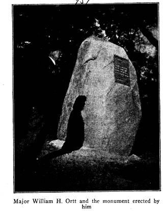
veteran of the Civil War -- Major W. H.
Ortt.
The monument was unveiled by little Miss
Marion McPher-
son of Eldorado, daughter of H. R.
McPherson, president of the
County Historical Society. A flag salute
of 21 rounds from a
cannon was fired. Prayer was offered by
the Rev. Charles F.
Irwin, Eaton Presbyterian Church, an
overseas chaplain and
chaplain of the American Legion post of
the county.
The monument dedicated at the old fort
stands fully eight
feet in height and weighs eight and
one-half tons. It is a native
Preble county boulder and was procured
from the farm of Clar-
ence Dalrymple, two and one-half miles
north of Eaton. A tablet
in the face of the monument bears this
inscription: "Erected
by William H. Ortt in October, 1922. Sacred to the
memory of
the soldiers who fought and died in the
battle with the Indians
at Ft. St. Clair, Nov. 6, 1792."
The tablet is of bronze, 21 by 16
inches, and is the handiwork of Dr. C.
M. Wilcox of New Paris.
The flag staff also was erected by Major
Ortt. A concrete base
has been installed at the fort to
receive a cannon and balls he
will contribute.
Graves of six warriors who fell in the
Indian battle have
been placed in proper condition and
marked with headstones.
The stones bear these names: Lieut. Job
Hale, Kentucky militia,
|
|

|
(512) |
Fort St. Clair 513
killed in battle with Indians, November
6, 1792; Orderly-
Sergeant Matthew English, Private John
Williams, Private Isaac
Jett, Private Joseph Clinton, Private
Robert Bolling.
The Indian hordes in the battle were led
by Little Turtle,
while Capt. John Adair led the
opposition. The fort took its
name from Gen. Arthur St. Clair, then
governor of the North-
west Territory.
The ceremonies observed upon the 130th
anniversary of the
Ft. St. Clair battle were conceived by
the county historical society,
formed a little more than a year ago. It
is the hope of the society
to reclaim the site of the old fort. A
plan of procedure looking to
this end is being worked out.
The attendance and manifest enjoyment
in the
celebration of this day evidenced the
fact that nothing
so stimulates interest in local history
as the participa-
tion of the public schools. Preble
County is fortunate
in having in its court house at Eaton
an ample audience
room communicating with the office of
the Superintend-
ent of Schools. This room was filled to
its capacity by
an attentive audience that remained
throughout the
rendition of the program.
The occasion brought visitors from
outside of the
county. Among them was Mrs. E. G.
Clerke, daughter
of Dr. C. M. Wilcox. She came from
Cincinnati and
acted as cannoneer in firing the salute
preceding the
dedicatory ceremonies at the monument.
The excellent
work inaugurated by the celebration of
St. Clair Day
at Eaton has had its sequel in
provision by the General
Assembly for the purchase of the St.
Clair site and its
improvement as detailed in the
following items included
in the appropriation bill passed by the
General As-
sembly.
Vol. XXXII -- 33.
|
|
|
Unveiling of monument by Miss Marian McPherson (514) |
Fort St.
Clair 515
For purchase of
Site of Fort St. Clair, Preble County,
Ohio, for
historical and forestry purposes (Title to
be vested in
The Ohio State Archaeological and
Historical
Society for State of Ohio) ........... $10,000
Buildings ......................................... 4,000
Roadway ........................................ 1,000
Total Site of
Fort St. Clair
................... $15,000
For this
commendable action the good people of
southeastern
Ohio and tourists from other parts of the
state are
under lasting obligations to the General As-
sembly and
especially to Honorable Harry D. Silver,
State
Representative from Preble County and chairman
of the Finance
Committee of the House, who in this
result has
crowned his excellent record of service to his
state and
county. The effective work that he inaugu-
rated in the
House was ably supported in the Senate by
Honorable G.
M. Kumler of Preble County, who repre-
sents the
Preble-Montgomery District.
THE STORY OF
FORT ST. CLAIR *
BY RALPH B.
EHLER
At the time
when my story begins, Ohio was prac-
tically
unsettled. The few settlers already here were
in constant
danger of the Indians, who were not at all
pleased with
the white man's presence in their Hunting
Grounds.
Prior to the
organization of civil government, cam-
paigns
directed by the settlers, against the Indians, had
failed to
secure peace. The National
Government,
however,
wishing to subdue the hostile Indians in the
Territory,
organized a number of military campaigns.
* Read at the
St. Clair celebration, November 6, 1922, Eaton, Preble
County, Ohio.
516 Ohio Arch. and Hist.
Society Publications
The first of these, led by General
Harmar, then com-
mander-in-chief of the armies in the
West, met with
defeat at Fort Wayne, Indiana, in 1790.
In 1791, General St. Clair, governor of
the territory,
organized the second expedition. About this time,
several Indian chiefs, among whom was
the famous
Little Turtle, were planning a
confederacy. By this
action, they hoped to be strong enough
to drive the set-
tlers beyond the Ohio River. It was St.
Clair's pur-
pose to stop this movement by erecting
a chain of forts
from the Ohio River to Lake Erie, and
in particular,
to gain possession of the headwaters of
the Maumee
River.
He organized his army at Pittsburgh in
April and
moved westward, arriving at Fort
Washington, now
Cincinnati, in May. After some delay,
he marched north
in September to a point on the Great
Miami and erected
the first of the proposed chain of
forts, Fort Hamilton,
on the present site of Hamilton.
Leaving a small portion of his army in
charge, he
again moved forward, this time marching
forty-four
miles. At this point, just six miles
south of the present
site of Greenville, he erected the
second fort, Fort Jef-
ferson. It was on this march that he first passed
through Preble county, his route being
along Seven Mile
Creek.
After the completion of this fort, his
next advance
was to the Indian villages on the
Maumee. Due to de-
sertion, his army was much smaller than
when he
started his campaign and upon his
arrival at Fort Re-
covery, numbered only 1400 men. It was
here that St.
Clair was overwhelmingly defeated by
the Indians on
November 4, 1791.
Fort St. Clair 517
This was the most disheartening
disaster in the an-
nals of American border warfare. The
loss of men
here was even greater in proportion to
the number en-
gaged than the loss in Braddock's
defeat. Out of 1400
men and 86 officers, 890 men and 16
officers were either
killed or badly wounded. After four
hours of serious
fighting, the remnant of St. Clair's
army fled pellmell
into the woods, going south over the
same route that
two days before they had marched, a well
organized
army. As a result of this defeat, the
whole territory
was thrown open to the savage attacks
of the Indians.
Although this battle was fought many
miles from
the place in which we are interested, a
knowledge of it
is necessary for a proper appreciation
of the condition
of the country at the time when Fort
St. Clair was built.
During the winter of 1791-92, just
after St. Clair's
defeat, Fort St. Clair was erected upon
the order of
General Wilkinson, who had succeeded
St. Clair as
commander of Fort Washington. It was to
serve as a
stepping stone of refuge between Fort
Hamilton and
Fort Jefferson. The work was under the
supervision
of Major Gano of the state militia.
Another prominent
person present at the erection of this
fort was Ensign
Harrison, later, President Harrison,
who had charge of
one shift of the alternate night
guards.
Like most of the forts, Fort St. Clair
was a stock-
ade, covering a few acres of ground,
containing block-
houses and officers' quarters. About
forty acres of for-
est were cleared away from around the
fort.
In October, 1792, a great council of
Indians, the
greatest of its kind, was held at Fort
Defiance and an
armistice was entered into which the
Indians agreed to
observe until the following spring.
Peace was not very
518
Ohio Arch. and Hist. Society Publications
faithfully observed, however, and was
first broken
within the boundaries of Preble County
at Fort St.
Clair on the sixth day of November,
1792.
One hundred Kentucky mounted riflemen,
under the
command of Major Adair, were acting as
an escort for
a brigade of pack horses from Fort
Washington to Fort
Jefferson. They were to make the trip
past Fort St.
Clair and return in six days, staying
each night under
the protection of one of the forts. At
this same time,
Little Turtle and two hundred and fifty
warriors were
planning an attack on a small
settlement just north of
Fort Washington. However, upon hearing
of the pack
train, the chief decided to attack it
instead upon its re-
turn trip, and with this in view, took
to ambush just
north of Fort Hamilton. According to
schedule, the
train was to arrive at Fort Hamilton on
Monday. Dis-
regarding the schedule, Adair laid over
at Fort Jeffer-
son on Sunday, and on Monday night, he
pitched camp
just outside of Fort St. Clair. Little
Turtle heard of
this through spies and at once left
ambush with the in-
tention of attacking the camp yet that
night.
It was just breaking dawn when, with a
volley of
shots and a roar of hideous yells, they
surprised the
camp. The yells frightened the horses
and many of
them broke loose. The Indians, desiring
to capture the
horses and to gather up all the loot
possible, seemed, for
a moment to forget about the militia.
Adair took ad-
vantage of this and called his men
together. This done,
he formed his men into three divisions.
Lieutenant
Madison was to attack the left flank,
Lieutenant Hale,
the center, and the Major with his
division, on the right.
As soon as it was light enough to distinguish
the whites
from the Indians, the attack was made.
It was in this
Fort St. Clair 519
attack that Lieutenant Hale was killed
and Madison
was wounded. The Indians were forced to
retreat some
distance where they then took a stand
and, in turn,
forced the militia back. This zigzag
method of fight-
ing was carried on for some time until
the Indians and
all but six of the horses were lost
sight of at about the
place where Eaton is now located.
The exact number of Indians killed in
this battle is
not definitely known, though two were
left and are
buried at the fort. Besides the graves
of the Indians at
the fort, there are the graves of
Lieutenant Hale,
Orderly Sergeant English, and Privates
Bowling, Jett,
Clinton, and Williams.
It is because of this battle that the
Historical So-
ciety of Preble County has set aside
November 6th as
St. Clair Day.
"FORTY FOOT PITCH"*
BY A. C. RISINGER
All peoples delight to discover and
preserve the
history of their pioneers, especially
the sturdy, courage-
ous, aggressive, primary pioneers who
ventured into the
wilds of the farther frontiers and
seized and subdued
the wilderness for themselves and their
posterity.
The history of the primary military and
civil pio-
neers of Preble County has been rather
fully developed
and preserved by various records and
documents and
in much part by oral traditions.
One historical mention, however, has
remained
somewhat obscure to the general
inquiring public and
* Read at the St. Clair celebration,
November 6, 1922, Eaton, Preble
County, Ohio.
520
Ohio Arch. and Hist. Society Publications
inquiry prevails as to the nature and
location of "Forty
Foot Pitch," which mention has
descended from early
historical notes and local traditions.
Thus considerable confusive conjecture
persists as
to "Forty Foot Pitch."
Some have surmised that the expression
relates to
a place incident to the activities of
General Arthur St.
Clair or of Captain John Adair. Others
have surmised
that the expression "Forty Foot
Pitch" is incident to the
encampment of Lieutenant Lowry at
Lowry's Run
about five miles north of Eaton and in
a gentle valley
south and west of Zion's Lutheran
Church. Others
have not only surmised but have
contended that "Forty
Foot Pitch" is a bold, barren
bluff about a quarter of
a mile east of Bantas Fork bridge
located three and one-
quarter miles north of Eaton on the
Eaton and West
Manchester road. This barren bluff is
in plain view of
travelers driving along the highway
over or near said
bridge. Others assert that "Forty
Foot Pitch" is down
Bantas Fork Creek about one-half mile
southeasterly
from said Bantas Fork bridge, on land
of the estate of
John Risinger.
The undersigned has been interviewed by
members
of the Preble County Historical Society
and requested
to write his knowledge and opinions as
to the true
location of "Forty Foot
Pitch."
I, said undersigned, have very familiar
personal
knowledge of said locations, said
knowledge, dating
from early childhood and persistent
through the years.
The topography of the vicinity of
Lowry's encamp-
ment on Lowry's Run is very gentle,
devoid of bold
bluffs, and the plateau descends in
gentle slopes to the
place of this encampment and there is
no feature of the
Fort St. Clair 521
topography suggestive of a
"pitch" and more than that,
the military documentary records give
no basis for be-
lief that said expression arises out of
the activities of
General St. Clair, Lieutenant Lowry or
Captain Adair.
The bold, barren bluff east of Bantas
Fork bridge is, by
dimension and reliable tradition,
excluded as the place
of "Forty Foot Pitch." I have recently made a
measurement of this bold barren bluff
and find that by
a taut tape it measures seventy-eight
feet from the top
to the bottom of said declivity. The
disparity between
forty feet and seventy-eight feet is at
least a basis for
strong skepticism.
The location situate about half a mile
down the
creek southeastward from said Bantas
Fork bridge is
undoubtedly the "Forty Foot
Pitch."
My father, Levi Risinger, in his
ninetieth year, has
very interesting and vivid
recollections, gathered from
personal observations and pioneer
traditions, as to this
latter place being "Forty Foot
Pitch."
Abel Risinger, Sr., my father's father,
acquired the
land east and southeast of Bantas Fork
bridge and lo-
cated there in the early part of 1800,
at which time
Anthony Wayne's military trail was very
distinctly
marked in the wilderness and this trail
disclosed that
when Wayne reached Bantas Fork Creek he
met the
impediment of a rather sharp shore or
bluff which he
must descend in order to cross over
said stream. This
bluff has a sharp declivity of about
forty feet. In order
to descend and cross the stream Anthony
Wayne made
an oblique road angling down said bluff
to the bottom
land below. This road down the bluff
was simply a
shoulder cut in the slope so that his
military train
passed down upon an oblique grade. All
of the pioneers
522
Ohio Arch. and Hist. Society
Publications
of that day spoke of this as the
"Forty Foot Pitch."
Said Risinger ancestor was a millwright
and farmer.
He cleared some of the land and
operated a saw mill
and a grist mill in the vicinity of
what is called "Forty
Foot Pitch." The country was
devoid of roads, nothing
but trails, and the pioneers scattered
through the wilder-
ness southward, made use of said
"Forty Foot Pitch"
in crossing the creek to the mills.
Levi Risinger was born half a mile from
said
oblique road cut in the bluff and in
his early boyhood
he knew of this cut as "Forty Foot
Pitch" and it was so
known and regarded by all the pioneer
settlers of that
country, -- the Kislings, Pences,
Kaylers, Christmans,
Craigs, Cottermans, Snyders, Days,
Kenneys, and
other well-known pioneer ancestors who
were all in ac-
cord in said understanding. The cut in
the bluff is yet
rather distinctly marked and this
summer the writer
had some fallen timber and debris cut
and burned off of
said cut which is yet so well preserved
that his father,
Levi Risinger, was transported up said
cut in an auto-
mobile and he was quite pleased to be
the first one to
ride up this ancient cut in a wondrous
chariot of modern
times.
In order to further fortify faith I
quote from a won-
derful and instructive address
delivered in Eaton by
Honorable Abner Haines on the 4th of
July, 1876. He
was a man of great intelligence, a
learned lawyer and
historian. Said address is preserved in
the Auditor's
Office in bound volume of the Eaton
Register of 1876.
I take this excerpt from the address:
The trace or military road of St. Clair
through the county of
Preble is so obscured by the lapse of
time that the true line is
now lost. It can only be recovered by
the original survey, pro-
Fort St. Clair 523
vided the notes were preserved and filed
at Washington in the
War Department. In the Spring of 1793, the advance portion of
General Wayne's army left Fort
Washington and began to as-
semble at Fort Greenville in Darke
County preparatory to their
march into the Indian country. General
Wayne substantially
adopted the route of General St. Clair
to Fort Hamilton, but
from this point he adopted a new route
to Fort Greenville,
passing on the east side of Sevenmile Creek in Preble
County,
which he cut through the wilderness.
Wayne's military road
passed up northward a short distance
east of the town site of
Eaton, and when the county was first
settled the line and open
way through the forest was plain and
distinct. Even the surface
roots of trees on the line showed
indubitable marks of having
been marred and bruised by the wheels of
wagons and ordnance
trains. The south part of said trail has
long since been estab-
lished as the public highway called
"The Old Trace Road".
Wayne's trail crosses Bantas Fork at or
near the "Forty Foot
Pitch" and attained the highlands
on the north side just west of a
sycamore tree on the east side of the
north road and thence ran a
little west of north to Fort Greenville.
There was some con-
fusion among the old settlers respecting
the origin of the name
"Forty Foot Pitch". Some
claimed that it originated from a
team sliding down the precipice, while
others said it was so noted
on the map of the route by military
engineers. The latter in all
probability is the true origin of the
name and so communicated
by the soldiers to the early settlers.
The salient suggestions of Mr. Haines
that Wayne's
trail passed a short distance east of
Eaton and went
northward and passed over Bantas Fork
at the cut in
the side of the declivity and the oral
traditions from the
pioneer settlers in that vicinity are
corroborated by Mr.
E. P. Vaughan, Esq., who is probably
the most learned
citizen of Preble County as to pioneer
military activities
and locations, who informs us that in
his judgment there
is no question as to the location of
Wayne's trail just
east of Eaton and northward along a
line parallel to the
Eaton and Greenville road, at least as
far as Wayne's
crossing at Bantas Fork. Mr. Andrew
Wikle, residing
a short distance east of Eaton, over
ninety years old
524
Ohio Arch. and Hist. Society Publications
and of remarkable general mentality,
corroborates the
statements of Honorable Mr. Haines and
the opinion of
Mr. Vaughan.
It will be noticed that Mr. Haines
mentions that "it"
-- that is, Wayne's Trail, --
"crosses Bantas Fork at or
near the Forty Foot Pitch and attained
the highlands on
the north side." The words
"at or near" are intelligible
to one understanding the earth
formations adjoining
the aforesaid ledge or shoulder cut in
the side of the
bluff. Just west of said cut or ledge,
almost adjoining,
is a barren bluff about forty feet high
caused by the
ancient erosion of the stream against
the face of the
bluff. It is very clear that it was the
opinion of Haines
that "Forty Foot Pitch" was
either the sidewise cut
upon the declivity or the barren
"pitch" proximately
adjoining. This matter is further
supplemented by re-
liable oral tradition from said Abel
Risinger, sr., and
Levi Risinger, his son, in this, --
that for a number of
years after said Risinger had located
and established
his mills as aforesaid the trace of
Anthony Wayne's
army after coming down the said oblique
cut or ledge
crossed over Bantas Fork proceeded
several rods north-
eastward and then up the gentle slope,
now a farm road
of John Risinger's estate, and thence
the army at the
upper end of the said gentle slope
proceeded westward
over the plateau and encamped on a high
area and close
to the edge of the barren slope
conspicuous from Bantas
Fork bridge. This encampment was
strategically lo-
cated by Wayne in that he thereby was
only required to
guard his army in minimum degree on the
west, as said
bluff was a protection and the guarding
line on the east
was limited practically to a
semi-circle.
Fort St. Clair 525
Levi Risinger in his boyhood days found
many mili-
tary mementoes of Wayne's encampment at
said place
and mementoes were occasionally found
along the line
of the trail backward up over said
oblique cut and down
across what is now the farm of said
Risinger.
Besides the historical data relative
trails and topog-
raphies reason dictates an argument
which I regard as
very conclusive that "Forty Foot
Pitch" means more
than a sharp barren declivity -- a
grassless, bushless
wall of earth. Sharp slanting bluffs
abounded along the
streams incident the pioneer military
trails in this
county and thus a bluff forty or eighty
feet, of less or
greater declivity, could not have
surprised or awakened
the interest of the St. Clair, Wayne or
Lowery soldiery
of 1791-2 and 3, and thus such a
common-place thing
as a declivity would not have had any
military mention
unless said common-place declivity was
connected with
some military situation, difficulty,
failure or success.
The writer does not know of any other
mention
whatever in the history of Preble
County, documentary
or traditional, of any other pitch than
"Forty Foot
Pitch." The numerous bold bluffs
observed by said
pioneer militia were not at all
significant or worthy of
mention and the only reason why said
pitch was men-
tioned is because it relates to a
military episode and
expedient. Wayne had reached the Bantas
Fork Val-
ley and had first descended a rather
gentle slope down
to the upper edge of said declivity,
steeply descending
about forty feet to the foot-land
below. Here was a
situation which required the particular
consideration of
Wayne and his military engineers. The
difficulty con-
fronting was to get down this pitch the
military wagons
526
Ohio Arch. and Hist. Society
Publications
and accoutrements. Wayne could not safely go di-
rectly down and thereupon he dug an
oblique shelf-road
in the breast of the declivity downward
-- eastward a
distance of about one hundred feet, and
thereby the
army descended to the floor of the
valley and crossed
the stream.
The shelf-road is not the
"pitch." It is the ex-
pedient made in breast of the pitch or
declivity. It is
a very interesting, well-preserved
remnant of Wayne's
Preble Trail. It is historically and sentimentally
worthy a permanent designation by an
attractive
monumental stone with a bronze tablet
insert inscribed
"WAYNE'S FORTY-FOOT PITCH"
THE BATTLE OF FORTY FOOT PITCH*
BY ESTHER E. NICHOLS
Today we are met to honor some of the
brave heroes
of our own state. Though inconspicuous
in the history
of our country, still they played a
most important part
in gaining for us a great Nation and
homes of safety.
Many of them were the close friends and
relatives of
our ancestors and they justly deserve
the gratitude and
respect which we, each one, can give.
Among those
who are most intimately connected with
the history of
our own country, are the brave heroes
who fell in the
Battle of Forty Foot Pitch, or Ludlow
Springs, a few
miles north of Eaton.
A month previous to this battle a great
confedera-
tion of Indians had been threatening
attacks, putting
* Read at the St. Clair celebration,
November 6, 1922, Eaton, Preble
County, Ohio.
Fort St. Clair 527
our infant Nation in a most perilous
position. General
Wayne, appointed by President
Washington, was in
command of an army of two thousand five
hundred
men at Fort Greenville, where the
present Greenville is
now situated. General Wayne was a man
of stern will
and we may rightly say had a heart full
of love for his
country. At that time it had become
very difficult to
furnish sufficient protection for the
many convoys of
supplies as the soldiers were all
needed to repel the
sudden, treacherous attacks of the
enemy at each fort.
The Battle of Forty Foot Pitch did not
occur at
what is now called Forty Foot Pitch but
really took
place at Ludlow Springs, Preble County,
Ohio, which
was probably located on the Montgomery
farm. This
site was supposed to be in a
picturesque little hollow
near the Zion Church, about seven miles
from Fort St.
Clair.
On the morning of the 17th of October,
1793, or
one hundred twenty-nine years ago, the
seventeenth of
last month, began the skirmish which
has meant so
much to us and in which we are
interested at present.
Lieutenant Lowery of the second Legion,
and En-
sign Boyd of the first, in charge of
one of those precious
convoys of provisions and in command of
about ninety
non-commissioned soldiers, were our
leaders in this
skirmish. At the head of the Indians was Little
Turtle, the chief of the Miamis, ready
to do his part in
maintaining the honor of his
tribes. This Indian
leader was a real gentleman and a most
sagacious
statesman. Even many of his enemies at
his death paid
him the highest of honors.
It has been said by old residents that,
as the soldiers
were looking for a place to camp, they
sent a few men
528
Ohio Arch. and Hist. Society Publications
ahead as usual to blaze the trail. When
the soldiers
came along a short time after, they
found a deer where
the battle later took place, so they
naturally supposed it
had been left there by the other men
who had blazed the
trail. Accordingly they camped in that
place, believing
the deer a sign that they should do so.
However it had
not been left by the blazers but by the
Indians, and the
Indians had in that way used strategy
in getting the
soldiers to camp at an advantageous
spot for an attack.
This is only a tradition, but at any
rate Lieutenant
Lowry and his men had camped at Ludlow
Springs al-
ways on the lookout for attacks and yet
not realizing any
immediate danger. Suddenly early on the
morning of
October 17th they found a band of
fierce Indians upon
them, led by the wary and able Little
Turtle. Upon the
very first discharge the unfortunate
little company of
white men were heartlessly abandoned by
the greater
part of their escort, but even in the
face of all this and
superior numbers they fought bravely
and obstinately.
Gradually their ranks were thinning. It
was then in the
crucial moment that Lieutenant Lowry
proved his
bravery. Heedless of his own suffering and
safety, his
supreme thought was the welfare of the
many helpless
ones at home. His last and inspiring
words were, "My
brave boys, all you that can fight,
now display your
activity and let your balls fly."
In addition to Lieutenant Lowry, there
was Ensign
Boyd, both promising young officers,
with about thirteen
officers and privates who were killed.
About seventy
horses were either killed or carried
off by the savages,
although the stores remained
undisturbed.
Those who fell in this encounter were
buried at Fort
St. Clair. Later, on July 4, 1846, the
bodies were taken
|
Fort St. Clair 529 up and re-interred, with impressive funeral services and all the honors of war. The bodies of Lieutenant Lowry and his men were afterwards removed to the mound in the cemetery at Eaton. A stately shaft marks their resting place which is now and will be throughout the centuries a monument of glory and honor for those who knew the true meaning of patriotism. The monument is one of the finest, made of elegant Rutland marble, twelve feet in height, erected on an artificial mound and constructed by La Do??n and Hamilton of Dayton at a cost of $300. This was gladly contributed by public- spirited persons who truly cherished the memory of ??ese beloved patriots. May we, as staunch citizens of our great United States and our own Ohio, remember this example of genuine patriotism and by doing our utmost at this present day save our country from many lurking perils and thus contribute our part in making it a land to be loved and cherished by the citizens of the near future. |
|
|

|
Vol. XXXII -- 34. |
FORT ST. CLAIR
CELEBRATION OF ST. CLAIR DAY
No history of the Northwest Territory
would be
complete without conspicuous reference
to what is now
Preble County, Ohio. Through its
primeval forests
General Arthur St. Clair, in the autumn
of 1791,
marched on his ill-fated expedition to
disastrous defeat
by the Indians near the present site of
Fort Recovery,
to return later in disorderly retreat.
Over the same
route General Anthony Wayne advanced
with his
legions, by careful stages, in October,
1793, to a signal
victory at the battle of Fallen
Timbers, in what is now
Lucas County, August 20, 1794. This
battle prepared
the way for the Treaty of Greenville,
August 3, 1795,
and the suspension of Indian incursions
until the cam-
paign of General William Henry Harrison
in 1811,
which culminated in the battle of
Tippecanoe.
The defeat of St. Clair left the
western border open
to the attacks of the Indians and
greatly retarded for
a time the settlement of the Ohio
Country. To afford
a measure of protection and stay the
advance of the
savage foe, Fort St. Clair was erected
between Fort
Hamilton and Fort Jefferson, on a site
about one mile
from the public square of Eaton.
The history of this fort, as detailed
in an address on
St. Clair Day, is presented on
following pages and need
not be repeated here. The accounts of
the battle that
was fought almost under the guns of the
fort are prac-
tically all based on a letter written
by Judge Joel Col-
(506)
(614) 297-2300