Ohio History Journal
- 1
- 2
- 3
- 4
- 5
|
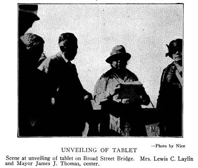
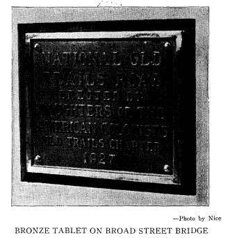
NATIONAL OLD TRAILS ROAD IN OHIO The Old Trails Chapter, Daughters of the American Colonists, Columbus, Ohio, unveiled a bronze tablet on the West Broad Street bridge, in Columbus, on October |
|
|
|
5, 1927. Mrs. W. C. Moore, Regent of the Chapter, pre- sided and Mayor James J. Thomas made introductory remarks. Mrs. Lewis C. Laylin, of Columbus, State Historian of the Daughters of American Colonists, gave a short history of the road in Ohio, and Mrs. Frank C. Martin, State Regent, unveiled the tablet, which was (143) |
144 Ohio Arch. and Hist. Society Publications
accepted by Judge John King, on behalf
of the city, and
by H. E. Barthman, chairman of the
Board of County
Commissioners of Franklin County, on
behalf of the
county. October 5, being the 102nd
anniversary of the
locating of the road by surveyors in
Columbus, was
chosen as the date for the ceremony. A
luncheon by
the Chapter at the Neil House, the old
stage-coach tav-
ern, preceded the ceremony.
On the occasion Mrs. Laylin spoke as
follows:
On the 5th of October, 1825, Jonathan
Knight, engaged in
locating the road from Zanesville
westward, arrived in Columbus
at the head of a corps of engineers,
among whom was Joseph E.
Johnston, afterward one of the most
distinguished generals of
the Confederate Army. The Ohio State
Journal of that date
announced that "Knight would return
to Zanesville and divide
the line he had located into half-mile
sections, and make esti-
mates of the probable cost of
construction." The line was prac-
tically a straight one, going about
seven miles south of Newark
and 14 miles north of Lancaster, and it
was mostly level except
in the hilly country near Zanesville.
During the summer of 1826, Engineers
Knight and Weaver,
with their assistants, completed the
permanent location of the
road as far as Zanesville and made a
preliminary survey of the
line from Columbus west to Indianapolis.
As to this part of
the road, the Ohio State Journal says,
"The adopted route leaves
Columbus at Broad Street and crosses the
Scioto River at the end
of that street on the new wooden bridge
erected in 1826. Thence
it passes through the village of
Franklinton and across the low
grounds to the bluff which is surmounted
at a depression formed
by a ravine at a point nearly in the
prolongation of Broad Street.
Thence by a small angle to the bluffs of
Darby Creek and thence
by nearly a straight line through Deer
Creek barrens, across that
stream to the dividing grounds between
the Scioto and Miami
Rivers, and thence down the valley to
Beaver Creek."
The criticisms that arose in the choice
of routes through
Licking and Franklin Counties caused
considerable delay in the
progress of the work and seem to have
assumed a political
aspect. In September, 1827, Mr. James
Kilbourne, then a candi-
date for Congress, announced that
"as to the location of the
National Road from Zanesville to
Columbus, he was decidedly
in favor of the straight and direct route
through the town of
|
National Old Trails Road in Ohio 145 Hebron." Efforts were made to have the General Assembly declare its preference for rival routes, but they failed. The controversy being settled, the Hebron route was chosen, and in July, 1830, the superintendent of construction gave notice that he would receive bids in Columbus for grubbing, cleaning and grading that part of the National Road from Columbus to Big Darby, a distance of twelve miles, and for constructing the |
|
|
|
bridges, culverts and other necessary masonry for the above space, also the same for 26 sections of one mile each east of Columbus extending to the Ohio Canal." Fourteen miles of the road westward from Columbus were put under contract about the same time, the first three miles to be graveled. An act of Congress, passed June 24, 1834, appropriated $200,000 for continuing the road through Ohio, and the same amount for Indiana and Illinois. This Act further provided that, as soon as completed, the finished portions of the road Vol. XXXVII--10. |
146 Ohio Arch. and Hist. Society Publications
should be surrendered to state control
and make no further claim
upon the United States Treasury. The total length of
the road
in Ohio was 320 miles, but that portion
between Springfield and
Indianapolis was uncompleted when it was
surrendered to the
State.
". . .The National Road, when
completed, appeared like a
white riband, meandering over the green
hills and valleys. It
was surfaced with broken limestone,
which, when compacted by
the pressure of heavy wagons, became
smooth as a floor and,
after a rain, almost as clean. Wagons,
stages, pedestrians, and
vast droves of cattle, sheep, horses and
hogs crowded it con-
stantly, all pressing eagerly by the
great arterial thoroughfare --
for there were no railways then -- to
the markets of the East.
Westwardly, on foot and in wagons,
traveled an interminable
caravan of emigrants or 'movers,' as
they were commonly called,
whose gypsy fires illuminated at night
the roadside woods and
meadows. For the heavy transportation,
both east and west,
huge covered wagons were used, built
with massive axles and
broad tires, and usually drawn by from
four to six, and some-
times eight horses. The teamsters who
conducted these 'moun-
tain ships,' as they were known in the
Alleghanies, were a peculiar
class of men, rough, hearty, whiskered
and sunburned, fond of
grog, voluble in their stories of
adventure and shockingly pro-
fane. Their horses were sturdy
roadsters, well-fed, shod and
curried, and heavily harnessed as became
the enormous burdens
they had to draw. When on duty, each of
the animals in the larger
teams bore upon its hames a chime of
from three to six small bells,
which jingled musically and no doubt
cheered the sweating toilers
at their task, while the groaning wain
rolled slowly but steadily
up hill and down. . . .
The road was frequented by traders,
hucksters, peddlers,
traveling musicians, small show-men,
sharpers, tramps, beggars,
and odd characters, some of whom made
periodical pilgrimages
and were familiar to the wayside
dwellers from Columbus to
Cumberland."*
To Columbus, as to many other towns and
cities along the
line, the opening of this great
thoroughfare was an event of great
importance and a commercial revolution.
To this splendid enter-
prise and to the statesmen who conceived
it, Ohio and her capital
owe an incalculable debt both material
and moral. The National
Road flourished until the railway era
dawned and then began its
decay. On April 6, 1876, the General
Assembly passed an act
surrendering the road to the care of the
counties, and on Octo-
* Lee, Alfred E., History of
the City of Columbus, Vol. I, p. 327.
National Old Trails Road in
Ohio 147
ber 23 of the same year, the city of
Columbus assumed the care
and control of it within its corporate
limits.
The Ohio National Stage Company operated
hundreds of
stages on the western division of the
road with headquarters in
Columbus. Mr. William Neil was one of
the magnates of this
company and the old "Neil
House," named for him, was its
Columbus headquarters. The
"Four-Mile House," west of Co-
lumbus, near Camp Chase of Civil War
fame, was built on this
road later in the century. Mr. Frank C.
Martin, of Columbus,
was born in this house.
"The first tavern built in Columbus
was opened in 1813, and
in 1816 it bore the sign 'The Lion and
the Eagle.' After 1817,
it was known as the 'Globe.' The
'Columbus Inn' and the
'White Horse Tavern' were other early
Columbus hostelries.
'Pike's Tavern' was opened in 1822 and the
'Golden Lamb' in
1825. The Neil House was opened in the
'twenties'--and was
the best-known early tavern in the old
coaching days in Ohio."*
The time required to go from Washington
to Columbus was
451/2 hours and the fare seven dollars.
The traveler will notice
still the mile-posts that mark the great road's
successive steps.
Those on the eastern portion of the road
are of iron, while those
on the west are mostly of sandstone and the markings on
them
are still quite legible.
* Hulbert, A. B., Historic Highways, Vol. X, p.
163.
|
NATIONAL OLD TRAILS ROAD IN OHIO The Old Trails Chapter, Daughters of the American Colonists, Columbus, Ohio, unveiled a bronze tablet on the West Broad Street bridge, in Columbus, on October |
|
|
|
5, 1927. Mrs. W. C. Moore, Regent of the Chapter, pre- sided and Mayor James J. Thomas made introductory remarks. Mrs. Lewis C. Laylin, of Columbus, State Historian of the Daughters of American Colonists, gave a short history of the road in Ohio, and Mrs. Frank C. Martin, State Regent, unveiled the tablet, which was (143) |
(614) 297-2300