Ohio History Journal


OHIO SURVEYS FROM THE AIR
By ALFRED
J. WRIGHT
Many Ohioans have been interested in
studying the evolution-
ary aspects of today's landscapes. Very
likely many more will
think along these lines during the year,
marked as it is by the
sesquicentennial celebration of the
founding of Ohio. There
have recently come into the possession
of the State Archaeological
and Historical Society some air
photographs of one aspect of this
evolutionary thought.
Through the good offices of the State
director of aeronautics
and the Materiel Division of the United
States Army Air Corps,
Wright Field, Dayton, these photographs
were taken with a view
toward establishing the persistence of
some original survey lines
in the present-day landscape. The use of
the airplane in making
aerial studies has met with considerable
success in the exhaustive
tests to which the method was put in the
Muskingum Conservancy
Project and in numerous archaeological
and historical studies.
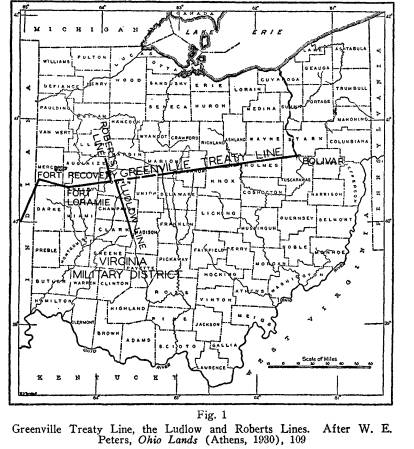
Major Fred Smith, formerly director of
aeronautics, located
these original survey lines on contour
sheets of the Ohio Coopera-
tive Topographic Survey. Thus oriented,
he photographed virtu-
ally all of the Ludlow and Roberts
Lines, and portions of the
Greenville Treaty Line. In the
accompanying photographs por-
tions of these original surveys are
indicated, generally in the center
of the view. They are necessarily
oblique photographs, taken at
an elevation of 12,000 feet. Distortion
prevents accurate scaling
of all but one of them--Fig. 5.
In a previous study, the writer ventured
some observations
relative to the influence of original
surveys upon Ohio town pat-
terns.1 In the meantime these
photographs have been made avail-
able to the end that persistence of
these lines may be observed in
rural as well as urban areas.
1 "Ohio Town Patterns," Geographical
Review (New York), XXVII (1937),
615-24.
(53)