Ohio History Journal
THE "DIVIDE."
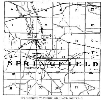
The Water-Shed of Richland County,
Ohio.
BY A. J. BAUGHMAN.
The far-famed barn, from the eaves of
which the rain-falls
flow from one side into Lake Erie and
from the other to the
Ohio river is situate near "Five
Corners" in Springfield township,
seven miles west of Mansfield, Richland
County, on the West
Fourth street, or Leesville road.
That this barn is not a myth but an
actual reality can be veri-
fied by a visit to the locality. The
farm upon which the building
stands is owned by C. Craig, a cousin of
Dr. J. H. Craig, of
Mansfield.
While this barn is not on the highest
point of land in the
state, it is upon the actual
"divide," and has an elevation of 832
feet above the lake, 965 feet above the
Ohio river, and 1,265 feet
above the sea. A mile east of the Craig
barn is the Ralston knob,
which reaches a higher elevation, but is
not a "divide," for the
surface waters from its several sides
all find their way into the
Mohican.
Contrary to the general opinion, the
roof of this barn does not
face north and south, but to the east
and west, being situate upon
a spur extending a short distance to the
north from the dividing
ridge proper, which traverses Ohio from
the northeast to the
southwest. From the east line of Ohio in
Ashtabula county, the
crest of the water-shed extends in a
tortuous course through
Trumbull, Geauga, Portage, Summit,
Medina, Wayne, Ashland,
Richland, Crawford, Marion and Hardin
counties and from the
latter it throws off a lofty spur into
Logan county, but the main
line continues from Hardin southwest
between Auglaize and
Shelby, through the corner of Mercer and
the northern part of
Darke to the Indiana line, at elevations
ranging from 400 to 900
feet. The gravel knobs - like the one at
Ralston's, are frequently
found along the divide, and are
interesting subjects in the study
of surface geology.
(160)
|
The "Divide." 161
The fountain-heads of the Sandusky and the Mohican rivers are only a half mile apart. The former has its source in the Palmer spring and the latter from a pond or little lake near the southeast corner of the cross-roads known as "Five Corners," one and a half miles north of Ontario. And about midway be- |
|
|
|
tween these two river sources is the Craig barn, where the surface waters separate. The pond mentioned has two outlets; from its east end flows the Black Fork, and from the west the Clear Fork of the Mo- hican. After running a quarter of a mile in an easterly direction, the little stream, which later becomes so dark as to be yclept "Black Fork," turns boldly to the north through a gap, and for |
162 Ohio Arch. and His. Society Publications.
several miles parallels the Sandusky,
but as they near the north
part of the township, the Sandusky veers
to the northwest,
passes through Tiffin and north to
Fremont and Sandusky Bay,
Lake Erie.
The Black Fork runs almost due north a
distance of ten
miles to Shelby and beyond, then turns
abruptly to the east, leaves
the south side of Holtz's grove, makes a
graceful bend at Ganges,
and after pursuing a tortuous course to
the southeast, turns to
the south after leaving the old site of
the Indian village of Green-
town, then glides slowly through
Perrysville and Loudonville,
and below the latter unites with the
Clear Fork after a crooked
course of 50 miles.
The output from the west end of the pond
runs to the south-
west for about a mile, then curves to
the southeast, is called the
Clear Fork, and after a journey of 35
miles, passing Bellville and
Newville, finally unites with the Black
Fork south of Loudonville,
forming the Mohican river.
That the Black and the Clear Forks of
the Mohican river
have the same source is a fact that is
but little known and was
never before published.
The peculiar topography of the country
enables the Black
Fork to take a course northward towards
the lake through a gap
-Shafer's Hollow-in the crest of the
watershed, and the
stream ripples cheerily along until its
course is turned by an eleva-
tion, which changes not only its course
but the color and character
of the stream as well, for thereafter
its waters become dark and
seem sullen and sluggish. But the Clear
Fork, as its name indi-
cates is clear and sparkling, carrying
health and good-cheer upon
its bosom, while smiles seem to play
upon the surface of its
waters.
The Craig neighborhood where these
interesting water
courses bubble up from gravelly depths,
now has trolly line con-
nections with both Crestline and
Mansfield, and Shafer's Hollow,
the gap in the "divide," has
become a picnic resort.
The Palmer spring - the source of the
Sandusky river - is
123
feet above Crestline, and supplies the
town with water through
pipes.
The "Divide." 163
Richland county is famous for high
altitude. The chestnut
ridge, three miles south of Bellville,
has an elevation of 952 feet
above the lake. The Sheckler hill on the
old state road three
miles north of Bellville, is 912 feet,
while the hill a mile north
of Sheckler's, upon which the German
Settlement church is
situated, has an elevation of 932 feet,
and the city of Mansfield,
according to the profile of the old S.,
M. & N. Railroad, is 657
feet above the lake. The Pennsylvania
roads mark it 592.
The local influence of this altitude
upon the climate, with its
isothermal lines and rain-shadings,
might here be considered and
reviewed, but are not strictly within
the province of this article.