Ohio History Journal
GEORGE WASHINGTON AT THE
GREAT BEND OF THE OHIO RIVER
GUY-HAROLD SMITH
There is a tradition that George
Washington took a
short cut across the Great Bend of the
Ohio River in the
autumn of 1770 when he made his journey
to the Ka-
nawha River. Since Washington went down
stream as
far as the Kanawha he had to cover that
section known
as the Great Bend both on the down
stream journey and
on his return. It is only logical that
he might want to
hasten his journey by cutting across
the sharp bends of
the river, and besides, this would have
given him an ex-
cellent opportunity to examine the
adjacent lands. It
must be remembered that Washington
carried provi-
sions and camping equipment in a large
canoe, and if
he did save distance by taking these
short cuts he prob-
ably had to wait for the canoe when he
again reached
the river.
In his journal Washington very commonly
writes
of the bottoms which he examined on his
river journey.
It would be easy to assume that the
land within the bends
of the river might be designated as
necks. Wherever
the river doubles sharply back it cuts
against the hills on
the outer portion of the curve leaving
a flat flood plain
and terrace within the bend. These
certainly are choice
areas of land but when Washington used
the expression
"neck of land" he was
referring, perhaps, to the narrow
strips of low land along the river, or
certainly, to the
(655)
656 Ohio Arch. and Hist. Society Publications
areas within the larger bends of the
river. On the first
day of his down stream journey, October
20, 1770, he
observed that the river swung across
the valley to flow
first on one side and then on the
other. On this day he
wrote:
"We passd several large Island[s]
which appeard
to [be] very good, as the bottoms also
did on each side
of the River, alternatly; the Hills on
one side being op-
posite to the bottoms on the other,
which seem generally
to be abt. 3 and 4 hundred yards wide,
and so vice
versa."
On Thursday, October 25, he observed
that there
was little ". . . alteration in
the general face of the
Country, except that the bottoms seemd
to be getting a
little longer and wider, as the Bends
of the River grew
larger." It is evident from this
that he had noticed not
only the character of the bottom lands
but the nature of
the bends of the river.
That Washington took a short cut across
the Great
Bend is so firmly fixed in the minds of
some of the peo-
ple along the Ohio River that it seems
almost a sacrilege
to question the strong tradition. Only
recently in an
article by Showalter1 an
insert map shows Washington's
principal journeys. On this map is
shown a short cut
across the Great Bend, or the Big Bend
as it is some-
times called.
Recently Myers,2 after the
present writer had com-
municated with him pointing out that
Washington did
1 William Joseph Showalter, "The
Travels of George Washington."
The National Geographic Magasine, Vol.
61, 1932. pp. 1-63. See insert map.
2 Clifford R. Myers, "Story of Washington at Great
Bend is Denied,"
The Charleston Gazette, May 1,
1932, Sec. 3, p. 5.
George Washington at Great Bend of
Ohio River 657
not cross the Great Bend, wrote a brief
newspaper article
calling attention to the inaccuracy of
this tradition.
Washington's camp site of Sunday, Oct.
28, is un-
certain but it probably was not far
from a location a few
miles above where Shade River enters
from the Ohio
Side.3 In connection with
the present problem this lo-
cation is not significant except to
establish the fact that
on the next day October 29, Washington
and his party
progressed down stream toward the Big
Bend. Many
features were mentioned by Washington
in his journal
but not all can be identified. His
entry in respect to the
Big Bend makes it possible to trace
with reasonable ac-
curacy his course down stream, for as
he noted the char-
acter of the land he mentions
tributaries which enter the
stream. Of one of these he writes,
"At the Mouth of
this Ck. which is 3 or 4 Miles above
two Islands (at the
lower end of the last is a rapid, and
the Point of the
Bend) is the Wariors Path to the
Cherokee Country;
for two Miles and a half below this the
River Runs a
No. Et. Course, and finishes what they
call the Great
Bent. Two Miles and a half below this
again we In-
campd."
The above entry for Monday, October 29,
indicates
that Washington and his party camped
five miles below
the point of the Great Bend. He
probably kindled his
camp fire on the south shore, though he
makes no specific
statement to that effect.
On Tuesday, October 30, Washington
continued
down-stream noting the horseshoe-shaped
lowland on
the south side of the river. On this
date he included a
3 Guy-Harold Smith, "Washington's
Camp Sites on the Ohio River,"
Ohio Archaeological and Historical
Quarterly, Vol. 41, 1932, p. 8. Also
see insert map.
Vol. XLI--42
658
Ohio Arch. and Hist. Society Publications
note about the bottom in which they
camped the night
before. He wrote, "The upper part
of the bottom we
Incampd in was an exceeding good one,
but the lower
part rather thin Land and covered with
Beach; in it is
some clear Meadow Land and a Pond or
Lake. This
bottom begins just below the Rapid at
the point of the
Great Bend, from whence a N. N. Wt.
course woud an-
swer to run a parrallel to the next
turn of the River."
If Washington camped on the Ohio side
of the river a
small circular bottom on the north side
could not have
been described in the terms used by
Washington. It
seems quite obvious that he was
describing the bottom
lands on the southwest side of the
river, though the bot-
tom does not extend quite to the point
of the Great Bend.
The pond or lake referred to cannot be
identified on the
modern topographic map of the area. He
noted that a
north-north west line from the point of
the Great Bend
would run parallel to the river to
where a southward
turn of the stream would again cross
his line.
Washington continued his journey to the
Kanawha
River which he ascended, but we are not
concerned here
with the details of his explorations of
the lands in the
territory adjacent to Point Pleasant at
the junction of
the Kanawha and Ohio Rivers.
It was on Sunday, November 4, that
Washington be-
gan his up-stream journey. The night
before he had
camped for a second time at Point
Pleasant. The bot-
tom lands along the southeast side of
the Ohio River and
above the mouth of the Kanawha are not
described with
complete accuracy, but his course
up-stream can be
charted with reasonable certainty. For
this date he
wrote, "After passing these Hills
(which may run on
George Washington at Great Bend of
Ohio River 659
the River near a Mile), there appears
to be another
pretty good Bottom on the East side. At
this place we
met a Canoe going to the Illinoies with
Sheep, and at this
place also, that is, at the end of the
Bottom from the
Kanhawa, just as we came to the Hills,
we met with a
Sycamore abt. 60 yards from the River
of a most extra-
ordinary size, it measuring (3 feet
from the Gd.) 45 feet
round, lacking two Inches, and not 50
yards from it was
another 31.4 round (3 feet from the Gd.
also.)
"The 2d Bottom hinted at the other
side (that is the
one lying above the Bottom that reaches
from the Kan-
hawa is that taken notice of the 30th
Ulto., to lye in
the shape of a Horse shoe, and must
from its situation
and quantity of level Ground be very
valuable, if the
Land is but tolerably good.
"After passing this bottom and
abt. a Mile of Hills,
we entered into the 3d Bottom and
Incampd. This bot-
tom reaches within about half a Mile of
the Rapid at the
point of the Great Bent."
Washington designated the
horseshoe-shaped bot-
tom as the second bottom above the
mouth of the Kan-
awha. There certainly can be no doubt
in the identifi-
cation, for there is only one area
along this part of the
Ohio which could be so described. On
the 30th of Oc-
tober he noted that "In about 2
Miles we came to the
head of a bottom (in the shape of a
horse Shoe) which
I judge to be about 6 Miles rd; the
beginning of the bot-
tom appeared to be very good Land, but
the lower part
(from the Growth) did not seem so
friendly. An east
course from the lower end woud strike
the River again
above, about the beging. of the
bottom."
On his down-stream journey Washington
stated that
660
Ohio, Arch. and Hist. Society Publications
this bottom in the shape of a horseshoe
begins two miles
below his camp of October 29. If he
camped five miles
below the point of the Great Bend, as
previously pointed
out, the distance to the beginning of
the horseshoe bend
is nearly six miles. Since there can be
little doubt about
the identification of this bottom we
must conclude that
Washington was uncertain about the
distance when he
came to write his journal for the 30th
of October.
This bottom is without doubt the second
one above
the mouth of the Kanawha according to
Washington's
numbering. The next bottom is the third
where the
party camped for the night. This
certainly is the bot-
tom just below the Great Bend even
though the flat land
along the south shore does not reach
"within about half
a Mile of the Rapid at the Point of the
Great Bent."
Since Washington made his journey it is
barely possible
that this great bend of the Ohio River
has cut away a
small portion of the up-stream end of
the lowland. This
hypothesis can hardly be entertained,
for the river now
flows in a distinct channel or valley
below the adjacent
bottoms, so the course of the river has
changed very lit-
tle since Washington's time.
The record for Monday, November 5, is
particularly
significant in any discussion of the
question as to
whether Washington actually took a
short cut across
the Great Bend. His journal begins,
"I set of the Canoe
with our Baggage and walked across the
Neck on foot
with Captn. Crawford, distant according
to our walking
about 8 Miles, as we kept a strait
course under the Foot
of the Hills, which run about So. Et.
and was two hours
and a half walking of it." From
the expression ". ..
walked across the Neck . . ." it
has become a tradition
|
|

|
(661) |
662
Ohio Arch. and Hist. Society Publications
that Washington walked across the Great
Bend, but this
interpretation can hardly be maintained
in the face of
additional evidence from the journal.
Cook in his little
book entitled Washington's Western Lands states
that Washington probably camped above
New Haven,
West Virginia, near the mouth of Broad
Creek. He con-
tinues by noting that "On Monday
morning, the fifth,
some of the party proceeded up the
river while Wash-
ington, in company with Captain
Crawford, landed on
the Ohio shore, perhaps below the mouth
of Tupper's
Run. Following the hills, the two men
walked across the
Big Bend, a distance of about eight
miles. It would seem
that the boat was again boarded above
the present Rip-
ley Landing and that the party encamped
for the night
near Towhead Island."4
With this interpretation of
Washington's course the
present writer does not agree.
Washington does not
mention crossing the river, nor is it
necessary to con-
clude that the neck of the land across
which he walked
lies within the curve of the Great
Bend.
Washington usually referred to the
narrow flat
lands along the river as bottoms, and,
as already sug-
gested, he noted their relationship to
the hills. On Oc-
tober 20, the day of the beginning of
his descent of the
Ohio River, he recorded in his journal
that the bottoms
occur alternately with the hills on
each side of the river,
and added that "the Hills on one
side being opposite to
the bottoms on the other." In at
least one other place he
used the term "neck" in
referring to a strip of bottom
land along the river. On Saturday,
October 27, Wash-
4 Roy Bird Cook, Washington's Western
Lands, Strasburg, Virginia,
1930, pp. 27-28.
George Washington at Great Bend of
Ohio River 663
ington, continuing his journey down
stream from his
camp site at the mouth of Duck Creek,
four miles above
Marietta, Ohio, passed the mouth of the
Muskingum
and continued on to the mouth of the
Little Kanawha.
After referring to the rich lands along
this latter sream
he observed that ". . . the
Country from hence quite up
to the 3 Islands,5 level and
in appearance fine; the River
(Ohio) running round it in the nature
of a horse shoe,
forms a Neck of flat Land wch. added to
that run'g up
to the 2d long reach (aforementioned)
cannot contain
less than 50,000 Acres in view."
The curve referred to
is far from resembling that at the
Great Bend. As a
matter of fact this curve is not shaped
like a horseshoe
but resembles in form the one formed by
the Ohio River
from the rapids at the point of the
Great Bend to his
camp site of November 4. The object of
this extended
discussion has been to indicate that a
"neck of land" as
used by Washington does not mean
necessarily the nar-
row neck produced by a river doubling
sharply back in
a meander-like curve.
Referring again to Washington's record
for No-
vember 5 we note that he and Captain
Crawford walked
about eight miles in a southeasterly
direction at the base
of the hills, and it required two and a
half hours to make
the journey. If Washington had been on
the north side
of the river a southeasterly course
across the Great Bend
would not coincide with a course at the
base of the hills.
Continuing his journal we read that
"This is a good
Neck of Land the Soil being generally
good; and in
places very rich. Their is a large
proportion of Meadow
Ground, and the land as high, dry, and
Level as one
5 About 16 miles above the mouth of the
Muskingum River.
|
664 Ohio Arch. and Hist. Society Publications coud wish. The growth in most places is beach inter- mixed with walnut, etca., but more especially with Pop- lar (of which there are numbers very large.) The Land |
|
|
|
toward the upper end is black oak, and very good; upon the whole a valuable Tract might be had here, and I judge the quantity to be about 4000 Acres." This account |
George Washington at Great Bend of
Ohio River 665
agrees substantially with his
observations on the same
area on Tuesday, October 30. On that
date he recorded
that "The upper part of the bottom
we Incampd in was
an exceeding good one, but the lower
part rather thin
Land and covered with Beach; in it some
clear Meadow
Land and a Pond or Lake." This
last named feature
cannot be identified on modern maps.
The last paragraph of Washington's
entry for No-
vember 5 is particularly pertinent in
connection with this
walk overland away from the river.
"After passing this
Bottom and the Rapid, as also some
Hills wch. jut pretty
close to the River, we came to that
Bottom before re-
markd., the 29th ulto; which being well
described, there
needs no further remark except that the
Bottom within
view appears to be exceeding rich; but
as I was not out
upon it, I cannot tell how it is back
from the River. A
little above this Bottom we Incamped,
the afternoon be-
ing rainy, and night wet."
Washington after passing this bottom
and the rapids
came to some hills close to the river.
This fits almost ex-
actly what he would have met with along
the south side
of the river. If he had taken a short
cut across the
Great Bend he would have missed the
rapids. In his
diary which he entitled "Where and
how my time is
Spent" the brief entry,
"Walk'd across a Neck of Land
to the Rapid and Incampd about Miles
above it" is a
bit of confirming evidence. He could
not have walked
across the neck of land on the north
side and reached the
rapids and held a course at the base of
the hills. The
writer is forced to the conclusion that
Washington did
not cross the Great Bend on Ohio
territory but made his
666
Ohio Arch. and Hist. Society Publications
eight-mile walk along the bottom on the
West Virginia
shore.
On a map recently published in The
George Wash-
ington Atlas6 this doubted walk across the Great Bend
on November 5 is shown as the only
place where Wash-
ington set foot in Ohio territory
except where he walked
from camp to canoe on the occasions
when he camped on
the Ohio side of the river. From his
entry of November
14 in the journal which has been partially
mutilated a
fragmented sentence reads as follows:
"About 2 or 3
Miles below . . . [Capte] ning I got
out (on the West
side) [and wal]kd through a Neck of as
good [land] as
ever I saw, between that and . . . k;
the Land on the
Hillsides. . .s rich as the bottoms;
than. . . nothing can
exceed, the bottom. . . the mouth of
Captening appears
. . . [to be of] equal goodness with
the one below."
There is very little strictly flat land
just below the mouth
of the Captina Creek but this is
certainly the area
through which Washington walked. How
far he con-
tinued on foot before he camped for the
night we cannot
be sure but from his entry for the
following day it ap-
pears that he may have walked at least
a mile above the
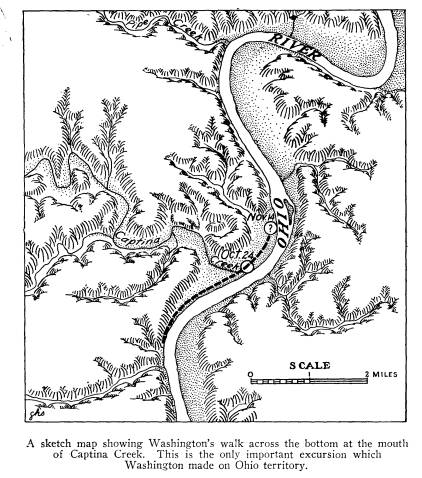
mouth of the Captina.7 On
November 15, the day after
Washington examined the lands above and
below the
Captina Creek he wrote in his journal,
"The canoe set
of [at su]nrise, as I did to view that.
. . opposite to the
Mouth of Pipe Creek." In this
statement it appears that
he crossed over to examine the bottom
on the east side
of the Ohio River.
7 Smith, Op. cit., p. 15. See
insert map also.
8 Lawrence Martin, Editor, The George
Washington Atlas, U. S.
Bicentennial Commission, Washington, D.
C., 1932. Plate 31.
|
George Washington at Great Bend of Ohio River 667 From the foregoing remarks there are two signifi- cant conclusions so far as Ohio is concerned. First, Washington did not cross the Great Bend, but walked along the hills and across a bottom on the West Virginia shore below the point of the Great Bend; and, second, Washington did make one short journey along the Ohio side of the river near the mouth of Captina Creek in ad- dition to the short walks from tent to canoe on the few nights when he camped on the Ohio shore. |
|
|