Ohio History Journal
EVOLUTION OF OHIO COUNTY BOUNDARIES
BY RANDOLPH CHANDLER DOWNES, M. A.
Instructor at Marietta College,
1925-1927
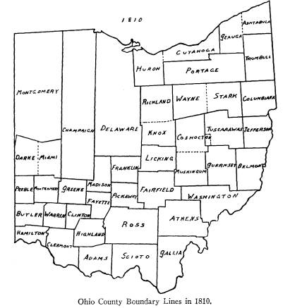
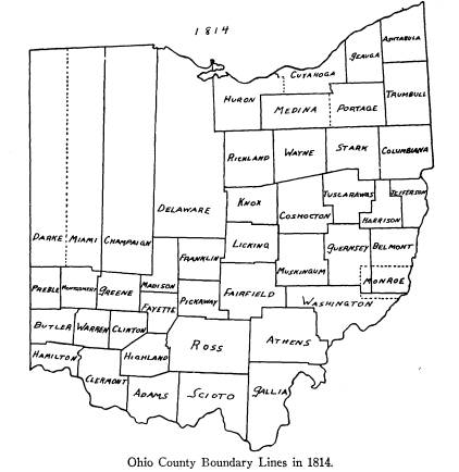
FORMATION OF COUNTIES
The first of Ohio's eighty-eight
counties was estab-
lished in 1788. The last revision in
the boundaries was
made in 1888, exactly one hundred years
later. The
following study has taken all the data
concerning the
boundaries, and by arranging them in
eighteen chrono-
logical groups, has presented
graphically the evolution
of Ohio's counties in eighteen maps.
Each map is ac-
companied by the necessary explanation
to make its
meaning clear and to establish
authorities for doubtful
points. At the end I have constructed
an alphabetical
list of the counties, with a
chronological list under each,
of all the legislative enactments
affecting that county.
An effort has been made to combine
strict accuracy
with simplicity of presentation. The
best authorities
on Ohio geography have been used in all
cases and have
been noted in the proper place. The bulk
of the locating
of the points in the laws was done in
the Map and Manu-
script Division of the Wisconsin
Historical Society.
The basic map used, was one by E.
Mendenhall & Co., en-
titled A New Map of the State of
Ohio from the Latest
and best Authorities, Exhibiting the
Sections, Fractional
Sections, Townships, . . . Cincinnati, Ohio, 1853. Scale,
about 5 miles to 1 inch. Many other
maps have been
used and are referred to whenever
difficulties in the lo-
(340)
|
Evolution of Ohio County Boundaries 341 cation of points have arisen. But most of the work in- volving the location of all points, of which there could be no doubt, has been done from Mendenhall's map of 1853. |
|
|
|
This map has been used because it is the first large-scale map of all the eighty-eight counties and hence the civil township lines conform more nearly to the early laws than they could in later maps. |
342
Ohio Arch and Hist. Society Publications
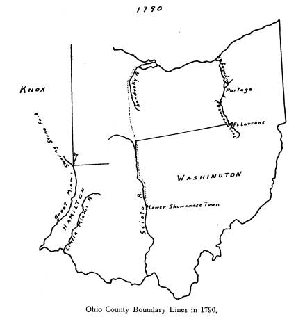
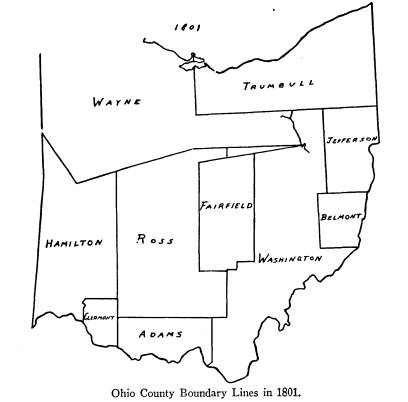
NEW COUNTIES
Washington -- July 27, 1788.
Beginning on the bank of the Ohio where
the west-
ern boundary line of Pennsylvania
crosses it; with that
line to Lake Erie; along the southern
shore of said Lake
to mouth of the Cuyahoga; up said river
to portage be-
tween that and the Tuscarawas branch of
the Mus-
kingum; down the branch to the forks at
the crossing
place above Fort Lawrence*; with a line
to be drawn
westerly to the portage on that branch
of the Big Miami
on which the fort stood that was taken
by the French
in 1752, until it meets the road from
the Lower Shaw-
nese Town to Sandusky; south to the
Scioto; down to
its mouth; up the Ohio to place of
beginning. Chase,
Statutes of Ohio, III, p. 2096.
W. H. Smith in his Life and Public
Services of
Arthur St. Clair, I, pp. 147-148, dates this proclamation
July 26, 1788. However, Miss Maud G.
Sites, of the
Library of Congress, writes me,
"The correct date is
July 27, 1788. I had in my hands and read this docu-
ment. In D. W. Parker's guide it is
numbered 6077,
p. 302."1 She adds, "Most of
the documents are copies
of the originals, and there is no way
of knowing where
the original documents are. It is
supposed that most of
them have been destroyed -- that is,
before they had a
chance to reach Washington."
* It will be noted that the spelling of
Fort Laurens is varied in this
text, due to the fact that the spelling
of the various authorities is quoted
exactly.
1 David W. Parker, Calendar of Papers
in Washington Archives Re-
lating to the Territories of the
United States (to 1873), Washington,
D. C.,
Carnegie Institute, 1911.
Evolution of Ohio County
Boundaries 343
The Cuyahoga Portage Line is taken from the Green-
ville Treaty Line as drawn in C. C.
Royce, Indian Land
Cessions in the United States, Washington, Government
Printing Office, 1900. Map No. 49,
entitled "Ohio."
The crossing place above Fort
Lawrence is shown to
be about a mile and a half above Fort
Laurens in C. E.
Sherman, Original Ohio Land
Subdivisions, Vol. III,
Final Report, Ohio Cooperative
Topographic Survey,
1925, Plate 20, p. 95.
The portage of that branch of the
Big Miami on
which the Fort stood that was taken
by the French in
1762, determines the direction of the line west from the
crossing place above Fort Laurens. It
coincides with
line of the Treaty of Fort McIntosh,
1785, by which some
of the Indian tribes released their
claims south of that
line.2 It also coincides
with the Greenville Treaty Line
of 1795. This line runs from the
crossing place above
Fort Laurens "westerly to a fork
of that branch of the
Great Miami River running into the
Ohio, at or near
which fork stood Loramie's Store and
where commences
the portage between the Miami of the
Ohio and St.
Mary's River, which is a branch of the
Miami which
runs into Lake Erie."3
The fort taken by the French in 1752,
as mentioned
in St. Clair's proclamation, is not, of
course, the same
as Loramie's Store referred to in the
Treaty Line. They
are, however, on the same stream,
Loramie's Creek, the
former being at the junction of the
creek with the Great
Miami, the latter up the river at the
St. Mary's portage
point.
2 U. S. Statutes, VII,
p. 16, Indian Treaties.
3 Ibid., p. 49.
344 Ohio Arch. and Hist.
Society Publications
Parkman refers to Fort Anglois which he
also calls
Fort Pickawillany as being at the mouth
of Loramie's
Creek.4 Miss Kellogg
describes how it was founded by
the Miami Chief, "La
Demoiselle," or "Old Britain,"
who led a delegation of the Miamis in
ceding from
French to English affiliation after the
war of 1740-1748.5
After 1748, English traders flocked
there and when
Christopher Gist arrived in February,
1751, the traders
had built a fort under Old Britain's
protection.6 Father
Bonnecamps, the Jesuit accompanying
Celoron de Bien-
ville among the Indian tribes in 1749,
refers to their ar-
rival at the village and saluting
"La Demoiselle" in his
Fort.7
This village of Pickawillany and its
fort were cap-
tured by Charles de Langlade in 1752.8
There was thus
established the basis for the French
supremacy and con-
trol of the fur trade of the Ohio
Valley which was the
cause of the great and far-reaching war
between France
and England from 1756 to 1763.
The Loramie's Store, referred to in the
Treaty Line,
was established in 1764 by the French
trader, Peter
Lorimier and his son, Louis, both of
Montreal.9 They
established their trading house at this
vantage-point on
the portage between the Great Miami and
the Maumee
Rivers and acquired a large influence
with the neighbor-
4 Francis Parkman, Montcalm and
Wolfe, Boston, 1887, Vol. I, pp. 51,
56.
5 Louise P. Kellogg, The French
Regime in Wisconsin and the North-
west, Madison, Wis., 1925, p. 413.
6 Quoted
from William M. Darlington's, Christopher Gist's Journals,
Pittsburgh, 1893, in C. A. Hanna, The
Wilderness Trail, New York, 1911, II,
pp. 271 ff.
7 Quoted in Hanna, II, p. 264.
8 Kellogg, pp. 421-422.
9 R. G. Thwaites in "Fur Trade on
the Upper Lakes 1778-1815" in
Collections of the State Historical
Society of Wisconsin, XIX, p. 265.
Evolution of Ohio County
Boundaries 345
ing Indians. The store was plundered
and burned by
George Rogers Clark and his Kentuckians
in 1782, be-
cause it was the basis of British and
Indian border expe-
ditions.10
The road from the Lower Shawanese Town to the
Sandusky. The intersection of this road and the Indian
Boundary Line is based on Thomas
Hutchins' map of
1778, entitled, "A New Map of the
Western parts of
Virginia, Pennsylvania . . .
comprehending the River
Ohio and all the Rivers which fall into
it . . ."11 This
map shows the road leading from the
"Lower Shawanoe
Town" on the upper Scioto, north
to the Sandusky. The
"Old Lower Shawanoe Town" is
placed at the mouth of
the Scioto River. Evans' map, referred to, locates
"Shawane Town"12 on the Ohio
at the mouth of the
Great Kanawha River. It is thus
apparent that the term
"Lower Shawanese Town," as
used by St. Clair in his
proclamation, is apt to be misleading.
The explanation
is, of course, that during this period
the Shawnees
moved their town up the Scioto River.
When we sift the evidence to find out
which Shaw-
nee Town St. Clair had in mind, we find
a direct conflict.
F. W. Hodge, in The Handbook of
American Indians
North of Mexico, says that the town indicated in this
10 A contemporary map showing the points
in the Indian Treaty Line
is Rufus Putnam's Map of Ohio in
January, 1804, in T. M. Harris, The
Journal of a Tour Northwest of the
Alleghany Mountains . . . Illustrated
with Original Maps and Views, Boston, 1805.
Ft. Pickawillany is also referred to as
Pique Town in Lewis Evans'
map extended by Pownall in Justin
Winsor, The Mississippi Basin, The
Struggle in America Between England
and France, 1697-1763, Boston and
New York, 1895, and in Charles Moore, The
Northwest Under Three
Flags, 1635-1796, New York and London, 1900, p. 80.
11 Louise P. Kellogg, "Frontier
Advance on the Upper Ohio, 1778-1779"
in Collections of the State
Historical Society of Wisconsin, XXIII, opposite
p. 321.
12 Winsor, The Mississippi Basin, p. 244.
346
Ohio Arch. and Hist. Society Publications
proclamation, was located at what is
now Chillicothe in
Ross County. He says that the town of
the Shawnees,
"was originally on the Ohio, just
below the mouth of the
Scioto, until it was carried off by a
flood, when it was
rebuilt on the opposite side of the
Scioto, about the site
of Portsmouth, Scioto County. It was
from here in
1750-1754, but before 1766, that the
inhabitants re-
moved up stream to Chillicothe, Ross County,
which
was frequently known as Lower Town or
Lower Shaw-
nee Town to distinguish it from Lick
Town, 25 miles
above."13 Lick Town was
near the present site of Cir-
cleville in Pickaway County and is thus
distinguished
from the Lower Shawnee Town in Hutchins'
map of
1778, referred to.
This assumption of Hodge's is a
mistake, as a con-
sideration of the following authorities
will show. West-
fall in Pickaway County, not
Chillicothe in Ross, is the
site of the Shawnee Town in question.
Dr. Louise P. Kellogg, of the Wisconsin
Historical
Society, cites Lyman C. Draper, in the
Draper Collec-
tions in the Wisconsin Historical
Society Library, as
follows: "Chillicothe, the
flourishing seat of justice of
Ross County, Ohio . . . does not occupy
the site of any
old Indian town. Old Chillicothe was
located on the
western bank of the Scioto, just above
the mouth of Lick
Run, where Westfall, in Pickaway
County, is now situ-
ated."
Henry Howe in his Historical
Collections of Ohio
(rev. ed., Columbus, 1891), II, p. 61,
shows on a map the
13 Smithsonian Institution, Bureau of
American Ethnology, Bulletin 30,
Handbook of American Indians North of
Mexico, edited by Frederick Webb
Hodge in Washington, 1907, House Doc.
926, 59th Cong., 1st Sess., Part I,
p. 777.
Evolution of Ohio County
Boundaries 347
site of Old Chillicothe four miles
below Circleville, or
approximately at Westfall. Howe also
says in Vol. II, p.
167, that the only Indian Town in Ross
County was at
Frankfort, thus excluding Chillicothe.
That Old Chillicothe and the Lower
Shawnee Town
were one and the same place, is
established by Hanna as
follows, "On Hutchins' map of
1778, the town at the
mouth of the Scioto is marked 'Old
Lower Shawnee
Town' and the place to which the
Shawnees removed is
called 'Lower Shawnee Town' situated on
both sides of
the Scioto, on the 'Plains.' There it
became known as
'Upper Chillicothe' or 'Old
Chillicothe,' four miles below
Circleville on and opposite the site of
Westfall."14
Hanna previously quotes from the entry
of November
28, 1758, of the Journal of George
Croghan, "The Dela-
wares informed me the Lower Shanoes had
removed off
the [Ohio] River up Sihotta, to a great
plain called Mo-
guck [now known as the Pickaway Plains,
in Pickaway
County]."15
Hamilton -- January 2, 1790.
Beginning on the bank of the Ohio at
the confluence
of the Little Miami; down the Ohio to
mouth of the Big
Miami; up the latter to the Standing
Stone Forks or
branch of said river; thence with a
line to be drawn east
to the Little Miami; down the Little
Miami to place of
beginning. Chase, Statutes of Ohio, III,
p. 2096.
Standing Stone Forks or branch of
Great Miami
River. There has been great difficulty in determining
which of the many forks of the Great
Miami is referred
14 Hanna II, p. 161.
15 Ibid, p. 160. See also the location of Moguck in the large
Map of
Trails at the end of Volume I.
348
Ohio Arch. and Hist. Society Publications
to. None of the early Ohio Gazetteers
refer to the
Standing Stone Forks of the Miami,
although its more
important forks are listed.
The History of Montgomery County, published by
W. H. Beers & Co., Chicago, 1880,
p. 252, states, "In the
point formed by that branch (of the
Great Miami on
which the fort stood which was taken by
the French in
1752) and Loramie's Creek, a stone was
planted to mark
the point at which the direction of the
boundary line
running west from a point on the
Tuscarawas . . .
changed from west by southwest to north
by northwest.
That stone stood about two miles south
of Old Fort
Loramie and the trading station, and
for a time Lora-
mie's Creek was known as the Standing
Stone Fork of
the Miami."
Who wrote this and on what authority is
unknown.
It is directly opposed to the location
of the Standing
Stone Forks by J. F. Laning, whose map
places the point
so that a line east actually would
intersect the Little
Miami River which it obviously could
not do if it were
to be drawn east from the mouth of
Loramie's Creek.16
There is some doubt about this
identification of the
Standing Stone Fork as to whether its
mouth is near the
stone itself or at the mouth of
Loramie's Creek near
Piqua. Until further evidence is found
to show that, in
the mind of St. Clair, the Great Miami
of 1790 turned
from the northwest instead of from the
northeast, I
have assumed the mouth of the stream to
be at the pres-
ent junction of the Great Miami and
Loramie's Creek.
Other published evidence helps, but is
not conclusive.
The History of Shelby County, Sutton & Co., 1882, p.
16 J. F. Laning, "The Evolution of
Ohio Counties," in Ohio State
Archaeological and Historical Society
Publications, V., p. 329.
Evolution of Ohio County
Boundaries 349
84, speaks of Hamilton County, as
formed in 1790, as
including all the territory between the
Big and Little
Miami Rivers and extending north to the
Standing
Stone Forks of the Big Miami.17 The History of Cin-
cinnati and Hamilton County, S. B. Nelson & Co., Pub-
lishers, Cincinnati, Ohio, 1894, p. 18,
states that in a
short time after 1790 there were
created several counties
out of the original Hamilton, one of
which was Miami.
All of Miami County is north of the
Little Miami River.
It included, of course, the County of
Shelby, in which
Loramie's Creek is located.
Not satisfied with the above evidence,
I have can-
vassed the present living authorities
in the state with
some degree of thoroughness. Mr. E. A.
Gast, Sur-
veyor of Hamilton County, has
interviewed several land
attorneys, county historians, and
surveyors on the sub-
ject, but has been unable to find
anything on the matter.
The official records of the boundaries
of Hamilton
County, which would contain helpful
information, were
destroyed in the court-house fire of
1884.
Miss Kellogg writes, "There seems
to be no doubt
that 'Standing Stone Fork' and
Loramie's were one and
the same." Mr. J. A. Rayner,
author of The First Cen-
tury of Piqua, Piqua, 1916, says, "I am afraid I can
give you very little data as to the
location of the 'Stand-
ing Stone Forks of the Great Miami.' I
know of no
outstanding rock or pinnacle at any
forks of this river
north of Dayton, and I do not think
there is any at that
point either." He dismisses the
suggestion of some that
it received its name from a high
pinnacle and bank of
gravel conglomerate at the mouth of
Swift Run, less
17 This is the same as in History of Van
Wert and Mercer Counties,
Ohio, Wapakoneta, Ohio, R. Sutton & Co., 1882, p.
84.
350
Ohio Arch. and Hist. Society Publications
than a mile south of Loramie's Creek,
by saying that
that pinnacle was formed in 1870, when
the Piqua
hydraulic basin was formed.
Mr. W. O. Pease, Surveyor of Miami
County, has
taken great pains to exhaust the
facilities within his
reach, but has been unable to settle
the matter. Mr. L.
H. Harman, Deputy Auditor of Shelby
County, writes:
"I believe Loramie's Creek is the
only stream corre-
sponding. Howe's Historical
Collections of Ohio gives
a brief account about this proposition,
and while the
information at hand is not absolutely
reliable, yet by
personal conversation with some friends
regarding the
matter, I have come to the conclusion
that Loramie's
Creek is the only stream corresponding."
It is possible that Laning's error is
only in drawing
the Little Miami too far north.
However, until some-
one comes forward with definite proof
to the contrary,
I believe I am justified in deciding in
favor of Loramie's
Creek on the basis of the evidence in
the History of
Montgomery County, by Miss Kellogg, and
by Mr.
Harman.
Knox -- June
20, 1790.
Beginning at the Standing Stone Forks
of the Great
Miami; down the river to the confluence
with the Ohio;
with Ohio to the small stream or
rivulet above Fort
Massac; with eastern boundary line of
St. Clair County
to mouth of Little Michilmacinack; up
the Illinois to
the Forks or confluence of the Theokiki
and Chicago;
thence by a line to be drawn north to
the boundary line
of the Territory of the United States;
and so far east-
erly upon said boundary line that a due
south line may
|
Evolution of Ohio County Boundaries 351 be drawn to the place of beginning. Smith, St. Clair Papers, II, p. 166. This county ultimately became Knox County, In- |
|
|
|
diana, and should not be confused with Knox County, Ohio. The law establishing it, therefore, is not to be found in Ohio statute books. |
352
Ohio Arch. and Hist. Society Publications
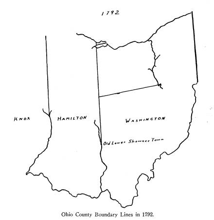
CHANGE IN BOUNDARY LINES
Hamilton -- Enlarged February 11, 1792.
Beginning at confluence of Scioto and
Ohio; up Sci-
oto to the upper part of the Old Lower
Shawanee Town
upon said river, with line north to
territorial boundary
line; westerly along said line to
eastern boundary of
Knox County; down along eastern
boundary of Knox
by due south line to the Standing Stone
Forks of the
Great Miami; with said Miami to its
confluence with
the Ohio; up the Ohio to place of
beginning. Smith, St.
Clair Papers, II, p. 310.
This law is not found in the Ohio laws
but is taken
from the official records of Sargent
for 1792 in the
State Department in Washington, D. C.
It is apparent
that the Lower Shawanese Town of St.
Clair's proc-
lamation, establishing Washington
County, July 26,
1788, has become the Old Lower Shawnee
Town in
Sargent's proclamation of 1792. This is
probably due
to the fact that the towns of the
Shawnee on the Great
Miami River had become more widely
known and hence
the town on the upper Scioto became
known as the Old
Lower Shawnee Town. However, the
Shawnee Town
at the mouth of the Scioto is called
Old Lower Shawnee
Town by Hutchins, in his map of 1778.
The white man
was not very successful in adapting his
labels to Indian
institutions.
The following excerpt of a letter from
Miss Sites
gives the official information on this:
"The [State]
Department [Division of Publications]
has no doubt
about this document being in Executive
Proceedings,
January 1 -- June 30, 1792 [of Governor
of Northwest
Territory], Parker, 6209, p. 308. But
so far they have
|
Evolution of Ohio County Boundaries 353 not been able to lay hands on it. Miss Phoeous, who was most kind in assisting in the search, thinks it is probably attached to some other document and will be uncovered eventually. . . . These Territorial Pa- pers are now being copied in the State Department." |
|
|
|
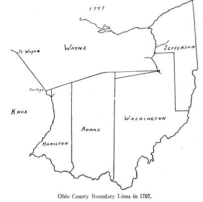
NEW COUNTIES Wayne -- August 15, 1796. Beginning at the mouth of the Cuyahoga River, upon Lake Erie, with said river to the portage, between it and the Tuscarawas branch of the Muskingum; down Vol. XXXVI--23. |
354
Ohio Arch. and Hist. Society Publications
said branch to the forks, at the
carrying place above
Fort Lawrence*; by a west line to the
eastern boundary
of Hamilton County (which is a due
north line from
the Lower Shawnese Town upon the Scioto
River); by
a line west-northerly to the southern
part of the portage,
between the Miamis of the Ohio and the
St. Mary's
River; by a line also west-northerly to
the south-western
part of the portage, between the Wabash
and the Mi-
amis of Lake Erie, where Fort Wayne now
stands; by
a line west-northerly to the most
southern part of Lake
Michigan; along the western shores of
the same, to the
northwest part thereof (including the
lands upon the
streams emptying into the said Lake);
by a north line
to the territorial boundary in Lake
Superior; with the
said boundary through Lakes Huron,
Sinclair, and
Erie, to the mouth of the Cuyahoga, the
place of begin-
ning. Chase, Statutes of Ohio, III,
p. 2096.
This county ultimately became Wayne
County,
Michigan, and should not be confused
with Wayne
County, Ohio.
It will be noted that the requirement
in the law to
draw a line "west northerly"
from a point due west
from the crossing place above Fort
Laurens to the
southern part of the portage between
the Miamis of the
Ohio and the St. Mary's River
(Loramie's Store) is an
impossibility because Loramie's Store
is a few minutes
of latitude south of Fort Laurens. Why
the southern
boundary of Wayne in 1796 was not made
to coincide
with the Greenville Treaty Line of 1795
is not clear.
The north boundary of Washington County
leaves a
triangular strip of land unorganized.
Hence it would
* Fort Laurens.
Evolution of Ohio County
Boundaries 355
not take a very great stretch of the
imagination to in-
terpret the southern line of Wayne as
coinciding with
the Greenville Treaty Line. Laning has
attempted to
draw this line, as if it were possible
to do so, and has
thus made Loramie's Store northwest of
Fort Laurens.
See Ohio Archeological and
Historical Society Publica-
tions, V, p. 334.
Adams -- July 10, 1797.
Beginning upon the Ohio at the upper
boundary of
that tract of twenty-four thousand
acres of land,
granted unto the French inhabitants of
Gallipolis, by Act
of Congress, March 3, 1795; down the
Ohio to mouth
of Elk River, (generally known by the
name of Eagle
Creek); up with the principal water of
Elk River or
Eagle Creek to its source; by a north
line to the southern
boundary of Wayne County, and easterly
along said
boundary so far that a south line shall
meet the interior
point of the upper boundary of the aforesaid
tract of
land of twenty-four thousand acres;
with said boundary
to the beginning. Chase, Statutes of
Ohio, III, p. 2096.
Jefferson -- July 29, 1797.
Beginning on the bank of the Ohio,
where the west-
ern boundary of Pennsylvania crosses
it; and down said
river to the southern boundary of the
fourth township
in third range; with said southern
boundary west to the
southwest corner of T* 6, R* 5; north
along the western
boundary of said R 5 to the termination
thereof; west
to the Muskingum; up the same to and
with the portage,
between it and the Cuyahoga; down the
Cuyahoga to
Lake Erie; easterly along the shores of
the lake to the
* T = township; R = range.
|
356 Ohio Arch. and Hist. Society Publications western boundary of Pennsylvania; and south with the same, to the place of beginning. Chase, Statutes of Ohio, III, p. 2096. |
|
|
|
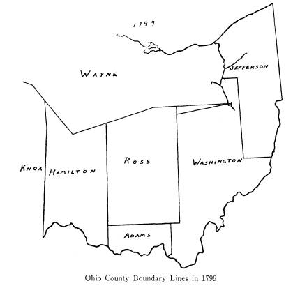
NEW COUNTIES Ross -- August 20, 1798. Beginning at the Forty-second Mile Tree, on the line of the original grant of land by the United States to the Ohio Company, which line was run by Israel Ludlow; thence west until it shall intersect a line to be drawn |
. Evolution of Ohio County
Boundaries 357
north from the mouth of Elk River
(commonly called
Eagle Creek); and from the point of
intersection run-
ning north to the southern boundary of
the County of
Wayne; easterly with said boundary of
Wayne until a
north line to be drawn from the place
of beginning,
shall intersect the same; and if it
should be found that
a north line drawn from the place of
beginning will not
intersect the said southern boundary of
Wayne, then an
east line is to be drawn from the eastern
termination of
the said boundary, until it shall
intersect the aforesaid
north line to be drawn from the place
of beginning.
Chase, Statutes of Ohio, III, p.
2097.
It is quite necessary to determine the
exact location
of this Forty-second Mile Tree at the
outset, because so
many subsequent county formations
depend upon it.
The county surveyors of the counties
concerned have
not been able to shed any light on
it. I have, how-
ever, been able by a process of
deduction, to determine
exactly where the point in question is.
On the west, "the line of the
original grant of land
by the United States to the Ohio
Company" is the line
between R 17 and 18. On the north, it
is a line west
from the Seven Ranges beginning on the
line between
T 4 and 5, R 8, according to the
contract of October 27,
1787, between the Ohio Company and the
Board of
Treasury of the United States.18 According
to Peters,19
only the north boundary line was
actually run by Lud-
low, but obviously the southeast corner
of Ross could
not be on it because it is north of the
present north
boundary of Ross. Therefore we must
assume that the
18 Peters, Ohio Lands, pp. 244, 249.
19 Peters, Ohio Lands, pp. 244,
247.
358
Ohio Arch. and Hist. Society Publications
west boundary is the one referred to
and the reference
to Ludlow is not entirely accurate.
The statute for the establishing of
Pike County, Jan-
uary 4, 1815, Acts of Ohio, XIII, p.
52, reads in part:
"thence with the section lines
north to Ross County line;
thence with the same east to the range
line between R 19
and 20; thence north with the range
line nine miles into
Ross County; thence west to
Highland." The southern
line of Ross, previous to 1815, was
thus a line nine miles
south of the present north boundary of
Pike, which if
extended west, intersects the west
boundary of the orig-
inal Ohio Company Grant at the
southeast corner of T
7, R 18, which is the Forty-second Mile
Tree referred to.
CHANGES
Hamilton from Knox -- June
22, 1798.
The western boundary of Hamilton shall
begin at the
spot on the bank of the Ohio, where the
general bound-
ary line between the lands of the
United States and the
Indian tribes, established at
Greenville, August 3, 1795,
intersects the bank of that river, and
run with that gen-
eral boundary line to Fort Recovery; by
a line to be
drawn north from Ft. Recovery until it
intersects the
said line from the Ohio to Fort
Recovery; thence to the
southern boundary of the County of
Wayne, shall
also be the eastern boundary of the
County of Knox.
Chase, Statutes of Ohio, III, p.
2097.
Hamilton from Adams -- September
1, 1798.
To begin on the bank of the Ohio where
Elk River or
Eagle Creek empties into the same;
north until it in-
tersects the southern boundary of Ross
County; and all
|
Evolution of Ohio County Boundaries 359 and singular the lands lying between said north line and Elk River or Eagle Creek shall, after the first day of September next, be separated from Hamilton County and added to the County of Adams. Chase, Statutes of Ohio, III, p. 2097. |
|
|
|
Jefferson from Washington -- December 19, 1799. Line dividing said counties shall be as follows: Be- ginning on the Ohio at the southern boundary of T 4, R 3, of those seven ranges of townships, surveyed in conformity to ordinance of Congress of May 20, 1785; with said southern boundary of said township west to |
360
Ohio Arch. and Hist. Society Publications
the southwest corner of T 7, R 6; north
along western
boundary of said range to termination
thereof, con-
tinued a north line until it strikes
the southern bound-
ary line of the Connecticut Reserve.
Chase, Statutes of
Ohio, III, p. 2098.
NEW COUNTIES
Trumbull -- July 10, 1800.
Beginning at completion of 41st degree
of north
latitude, 120 miles west of the western
boundary of
Pennsylvania, running by a line to be drawn
north
parallel to and 120 miles west of said
west line of Penn-
sylvania, to continue north until it
comes to 42 degrees 2
minutes north latitude; with a line to
be drawn east until
it intersects the said western boundary
of Pennsylvania;
thence with said western boundary of
Pennsylvania
south to the completion of the 41st
degree of north lati-
tude; thence west to the place of
beginning. Chase,
Statutes of Ohio, III, p. 2097.
Clermont -- December 6, 1800.
Beginning at the mouth of Nine-Mile or
Muddy
Creek where it discharges itself into
the Ohio, running
with a straight line to the mouth of
the east branch of
the Little Miami River; with said river
to the mouth of
O'Banion's Creek; with a due east line
until it shall in-
tersect a line drawn due north from the
mouth of Elk
River, or Eagle Creek; with that line
south to the mouth
of said Elk River or Eagle Creek; from
thence with the
Ohio to the place of beginning. Chase, Statutes
of Ohio,
III, p. 2097.
Evolution of Ohio County
Boundaries 361
Fairfield -- December 9, 1800.
Beginning at a point in the east line
of the 15th range
of townships and west of the 14th
range, as surveyed
in pursuance of the ordinance of
Congress of May 20,
1795, where said line intersects the
south boundary line
of the Military Land; north until it
intersects the Indian
Boundary Line; returning to the
before-mentioned and
running south by the said range line
between the 14th
and 15th ranges, until it intersects
the north boundary
line of the Ohio Company's purchase;
with said northern
boundary line west to the northwest
corner of the said
Ohio Company's purchase; south six
miles; with a line
drawn west until it intersects the
western boundary of
the 20th range of townships; with the
western boundary
of said 20th range to the
before-mentioned Indian
Boundary Line, and with that line of
limit to the before-
mentioned intersection of that boundary
line. Chase.
Statutes of Ohio, III, p. 2097.
The reference to the "Ordinance of
the 20th of May,
1795" is obviously a misprint, for
the term ordinance is
used of the acts of Congress previous
to 1789. The Or-
dinance of May 20, 1785, is, of course,
the law meant.20
It should be noted that the north
boundary of Fair-
field is the Greenville Treaty Line,
whereas the Wayne
County line is the north boundary of
Ross. The re-
sultant clumsy formation of Ross is
additional evidence
in favor of the Greenville Line as the
southern boundary
of Wayne.
The jog in the south boundary is caused
by the cor-
rection line established on the line
between Ranges 17
and 18.21
20 Journals of Continental
Congress, X., pp. 122-123.
21 Peters, Ohio Lands, p. 126.
|
362 Ohio Arch. and Hist. Society Publications Belmont -- September 7, 1801. Beginning on the Ohio, at the middle of T 4, R 2, in the Seven Ranges, with the line between the 3rd and 4th sections of that township north, to the west boundary |
|
|
|
of the said Seven Ranges; south with said west bound- ary to the middle of T 5, R 7; east with the line between the 3rd and 4th sections of T 5, to the Ohio, with the Ohio to the place of beginning. Chase, Statutes of Ohio, III, p. 2098. |
Evolution of Ohio County
Boundaries 363
CHANGE
Wayne -- May 7, 1800.
By the act of Congress of May 7,
1800, the western
boundary of the Northwest Territory was
made the
Greenville Treaty Line to Fort Recovery
and thence
north to the International Line, thus
cutting off the
western portion of Wayne.22
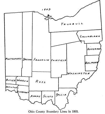
NEW COUNTIES AS ORGANIZED
GENERAL EXPLANATION
This is the beginning of county
formation under
statehood, and the boundary references
are to the Ses-
sion Laws of the Legislature referred
to as Acts of
Ohio until 1821, when the Local Laws
are printed sep-
arately and referred to as O. L. L.,
Ohio Local Laws.
With the formation of the State of
Ohio, Wayne
County no longer falls within its
boundaries. The west-
ern boundary of the state is, of
course, not the Green-
ville Treaty Line, but the line north
from the mouth of
the Great Miami, which line is the
present western
boundary.
The new counties will be arranged in
the order in
which they were organized and went into
effect, and not
in the order by which the laws
establishing them were
passed. In some counties the
organization was effective
on passage of the law. In others, it
was stated in the
law that organization should take place
on given date
shortly following. In still others,
organization was post-
poned until the Legislature saw
fit to organize it, while,
in the meantime, it remained attached
to the parent
county or counties.
22 U. S. Statutes, II, p. 59.
364
Ohio Arch. and Hist. Society Publications
Gallia -- April 30, 1803.
Beginning at the mouth of Shade River,
up the same
with the meanders thereof, until it
intersects the east
and west line between T 3 and 4, R 11;
west to the east
boundary of Ross County; south to the
northeast corner
of the County of Adams; with the
easterly boundary
of the same to the Ohio; up the same to
the place of be-
ginning. Acts of Ohio, I, pp.
19-20. Passed March 25,
1803.
Franklin -- April 30, 1803.
Beginning on the western boundary of R
20 of
townships east of the Scioto, at the
corner of Sections
24 and 25, T 9, R 21, surveyed by John
Matthews; west
until it intersects the eastern
boundary of Greene Coun-
ty; north with said line to state line;
eastwardly with the
said line to the northwest corner of
Fairfield County;
with the western boundary line of
Fairfield to the point
of beginning. Acts of Ohio, I,
pp. 26-27. Passed March
30, 1803.
It will be seen by a reference to Plate
25 in Sherman,
Ohio Land Subdivisions, that the townships in R 21 and
22 are not numbered consecutively north
from the Ohio
River, but repeat themselves. For
instance, there are two
sets of townships numbered 9, 10 and
11, in R 21. This
is due to the failure to cooperate, in
1799, of the survey-
ors of the United States Lands directly
east of the Scioto
River. These surveyors were Elias
Langham, Thomas
Worthington, John Matthews and Ebenezer
Bucking-
ham.1
It will be noticed that the west
boundary of Franklin
1 Sherman, Ohio Land Subdivisions, pp.
113, 119-120.
Evolution of Ohio County
Boundaries 365
is made to extend north to the state
line, thence east to
the northwest corner of Fairfield. When
we recall that
the northwest corner of Fairfield
County was on the
Greenville Treaty Line, we find these
instructions hard
to follow.
Scioto -- May 1, 1803.
Beginning on the Ohio one mile on a
straight line
below the mouth of the Lower
Twin-Creek; north to
Ross County line; east with said county
line to the line
of Washington County; south to the
Ohio; with the
Ohio to the place of beginning. Acts
of Ohio, I, pp.
8-9. Passed March 24, 1803.
Warren -- May 1, 1803.
Beginning at the northeast corner of
Clermont; west
with the line of said county to the
Little Miami; up the
same to the north boundary of the first
tier of sections
in the second entire range of townships
in the Miami
Purchase; west to the northeast corner
of Section 7 in
T 3 of aforesaid range; north to the
Great Miami; up
the same to the middle of R 5; east to
the Ross County
line; with same south to the place of
beginning. Acts of
Ohio, I, pp. 9-10. Passed March 24, 1803.
The ranges in this survey between the
Miami Rivers
run from west to east. The first two,
called Fractional
Ranges, are numbered one and two. The
third to the
seventeenth are numbered consecutively
from one to fif-
teen.2
It should be noted that the range and
township lines
in the survey between the Miami Rivers
are not parallel
to the lines of the Miami River Survey.
This accounts
2 Sherman, Ohio Land Subdivisions, p.
71.
366
Ohio Arch. and Hist. Society Publications
for the noticeable slant in the
boundaries east of the
Great Miami River. See Sherman's large
map.3
Butler -- May 1, 1803.
Beginning at the northeast corner of
Section 7, T 3,
R 2 in the Miami Purchase; west to the
state line; north
to a point due west from the middle of
the fifth range of
townships of the Miami Purchase; east
to the Great
Miami River; and bounded on the east by
the Miami
River and a line running north on the
section line from
the place of beginning to the Miami
River. Acts of
Ohio, I, p. 10. Passed March 24, 1803.
Montgomery -- May
1, 1803.
All that part of the County of
Hamilton, beginning
on the state line at the northwest
corner of Butler; east
with the lines of Butler and Warren to
the east line of
Section 16, T 3, R 5; north 18 miles;
east 2 miles; north
to the state line; to the west boundary
of the State;
south to the beginning. Acts of
Ohio, I, pp. 10-11.
Passed March 24, 1803.
Greene -- May 1, 1803.
All of Hamilton and Ross -- beginning
at the south-
east corner of Montgomery County; east
to Ross County
line and the same course continued 8
miles into the said
County of Ross; north to the state
line; westwardly to
the east line of Montgomery County;
south to the begin-
ning. Acts of Ohio, I, p. 11.
Passed March 24, 1803.
3 This map is entitled, Hon. A. V.
Donahey, Governor of Ohio, Map
of Ohio, showing original land
subdivisions to accompany Volume III,
Final Report, Ohio Co-operative
Topographic Survey by C. E. Sherman,
C. E., W. D. Turnbull, Chief Draftsman.
Scale 6 miles to 1 inch.
Evolution of Ohio County
Boundaries 367
Columbiana -- May 1, 1803.
All of Jefferson and Washington --
beginning at the
mouth of Yellow Creek, on the north
side of the same;
up said creek with the meanders thereof
to the northern
boundary of T 8, R 2; west to the
western boundary of
R 7; north to the northwest corner of T
16, R 7; west
to the Muskingum River; up said river
to the southern
boundary of Trumbull; east to the
Pennsylvania line;
south to the Ohio River; down the same
to the begin-
ning. Acts of Ohio, I, pp.
15-16. Passed March 25,
1803.
That part of the west boundary of
Columbiana from
the northwest corner of T 16, R 7, to
the Muskingum or
Tuscarawas River, is the extension of
the so-called
Geographer's Line. By the ordinance of
1785, this was
required to be drawn due west from the
point where the
Ohio crosses the Pennsylvania line. The
townships and
ranges were laid off with it as a
basis. The exact loca-
tion of the intersection of its extension
with the Tus-
carawas River is shown by Sherman in
Plate 20.4
It should be noted that the lines of
the Western Re-
serve Survey are not exactly parallel
to the lines of the
United States Survey. See Sherman's
map.
CHANGE
Hamilton -- April 30, 1802.
The triangle bounded by the line from
the Kentucky
River to Fort Recovery, the line due
north from the
mouth of the Great Miami, and the Ohio
River, was de-
tached from Hamilton, when the State of
Ohio came into
existence. Since the exact date is
uncertain, I have used
4 Sherman, pp. 41-42, 95.
|
368 Ohio Arch. and Hist. Society Publications the date of the Enabling Act of Congress, which con- tains the first official statement of Ohio's boundaries.5 |
|
|
|
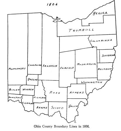
NEW COUNTIES Muskingum -- March 1, 1804. All of Washington and Fairfield -- beginning at the northwest corner of T 9, R 9, of the United States Mili- tary Lands; south to the southern boundary of said Mili- U. S. Statutes, II, p. 173. |
Evolution of Ohio County
Boundaries 369
tary Lands; west to the west boundary
line of R 15 of
Public Lands; south to the southwest
corner of T 16, R
15; east with the southern boundary of
T 16, till it in-
tersects the west boundary of R 12;
east to the west-
ern boundary line of R 7;- north to the
northeast
corner of the Military Tract; west
until intersected by
the Indian Boundary Line; westwardly to
place of begin-
ning. Acts of Ohio, III, pp.
359-361. Passed January
7, 1804.
For the boundaries of the United States
Military
Tract, see Sherman, Plate 19, and
explanation.6 The
eastern part of the north line of
Muskingum is the ex-
tension of the Geographer's Line
already referred to.
By extending it west to the Greenville
Treaty Line it is
made to cross the Tuscarawas River,
without including
in Muskingum County the region north of
it bounded
by the Greenville Treaty Line and the
Tuscarawas
River. Thus, this region is neither in
Columbiana nor
in Muskingum, and, until the formation
of Stark in
1808, was unattached. This situation
can be seen
from the large-scale map in Sherman,
Plate 20.7
It will be noticed with the eastern
boundary of Mus-
kingum at the west line of the Seven
Ranges, all of R 7,
west of Jefferson, is not attached to
any county. It was
added to Jefferson in 1807.
The region between the Reserve and the
United
State Military District is likewise
unattached. This
region had been ceded by the Indians to
the United
States at the Treaty of Fort Industry,
July 4, 1805,8 but
was not organized into counties until
1808.
6 Sherman, Ohio Land Subdivisions, pp.
91, 92.
7 Ibid, p 95.
8 U. S.
Statutes, VII, p. 87.
Vol. XXXVI--24
370
Ohio Arch. and Hist. Society Publications
The townships in the United States
Military District
were only five miles square.9
Highland -- March 1, 1805.
All of Ross, Adams and Clermont --
beginning at
the Twenty Mile Tree in the line
between Adams and
Clermont; east 12 miles;
northeastwardly until it inter-
sects the line which was run between
Ross, Scioto and
Adams at the Eighteen Mile Tree from
the Scioto Riv-
er; northwardly to the mouth of the
Rocky Fork of
Paint Creek; up main Paint Creek to the
south line of
Franklin; west to the east line of
Greene; south to the
southeast corner of said county; west
to the northeast
corner of Clermont; and from the
beginning west to the
north fork of White Oak Creek; north to
the south line
of Warren; east to the corner between
Clermont and
Warren. Acts of Ohio, III, pp.
256-258. Passed Feb-
ruary 18, 1805.
Highland County is within the Virginia
Military Dis-
trict where there has been no
application of the rec-
tangular system of surveys.10
Athens -- March 1, 1805.
Part of Washington -- beginning at the
southwest
corner of T 10, R 17; east with the
line between Gallia
and Washington, to the Ohio, up said
river to the mouth
of the Big Hockhocking River; up said
river to the east
line of T 6, R 12; north to the
northeast corner of T 8,
R 12; west to the east line of
Fairfield; south on said
county line and the line of Ross County
to the place of
beginning. Acts of Ohio, III,
pp. 283-285. Passed
February 20, 1805.
9 Sherman, Chapter VIII.
10 Ibid., Chapter
II.
Evolution of Ohio County
Boundaries 371
Champaign -- March 1, 1805.
Parts of Greene and Franklin --
beginning where
the range line, between R 8 and 9,
between the Great and
Little Miamis, intersects the east
boundary of Greene,
and to continue 6 miles into the County
of Franklin;
north to the state line; west with said
line until it inter-
sects the said east boundary of
Montgomery; to the place
of beginning. Acts of Ohio, III,
pp. 285-286. Passed
February 20, 1805.
Geauga -- March 1, 1806.
Part of Trumbull lying north and east
of the line
beginning on the east line of said
county, on the line
between T 8 and 9, as known by the
survey of said
county; west to the west line of R 5;
south to the north-
west corner of T 5; west to the middle
of the Cuyahoga
River; up the middle of said river to
the intersection of
the north line of T 4; west to the west
line of R 14;
wherever the same shall run, when the
county west of
the Cuyahoga shall be surveyed into townships
or tracts
of 5 miles square each; north to Lake
Erie. Acts of
Ohio, IV, pp. 65-66. Passed December 31, 1805.
The townships of the Western Reserve
were only
five miles square according to the
Connecticut system.11
CHANGE
Scioto from Gallia -- December 29, 1804.
All of Gallia, west of R 17, annexed to
Scioto. Acts
of Ohio, III, p. 294. Passed December 29, 1804.
11 Sherman, Chapter VII.
|
372 Ohio Arch. and Hist. Society Publications NEW COUNTIES Miami -- March 1, 1807. All of Montgomery beginning at the southwest cor- ner of Champaign and southeast corner of Section 1, |
|
|
|
T2, R9, between the Miamis; west with the line between the 8th and 9th ranges to the Great Miami, crossing the same in such direction as to take the line on the bank of the said river, between T 3 and 4, R 6, west of said |
Evolution of Ohio County
Boundaries 373
river; west to the state line; north to
the Indian Bound-
ary Line; east with the same to
Champaign County line;
south to the place of beginning. Acts
of Ohio, V, pp.
94-96. Passed January 16, 1807.
The land north of the Greenville Treaty
Line, which
is the north boundary of Miami, was
included in Mont-
gomery at the formation of the latter
in 1803. It was
not added to Miami until 1812.
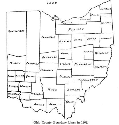
Licking -- March 1, 1808.
Part of Fairfield beginning at the northeast
corner
of T 17, R 16; west with the township
line to the west
boundary of R 17; south to the
northeast corner of Sec-
tion 24, T 17, R 18; west to the west
boundary of R 20;
north to the south boundary of the
Military Tract; east
to the line between R 15 and 16 of the
Military Tract,
which line shall be the east line of
Franklin; north to the
northwest corner of T 4, R 15, of said
lands; east to the
northeast corner of T 4, R 10; to the
place of beginning.
Acts of Ohio, VI, pp. 21-22. Passed January 30, 1808.
Knox -- March 1, 1808.
Beginning at the southeast corner of T
5, R 10, of
United States Military District, west
along the north
boundary line of said County of Licking
to the line be-
tween R 15 and 16; north to the north
boundary of the
Military Land; westwardly along said
north boundary
line to the west boundary of R 20, of
the lands of the
United States, lying north of said
Military Lands; north
to the northwest corner of T 17, R 20;
east until it in-
tersects the north boundary of Military
Land; eastward-
ly along said north boundary line to
the east boundary
374 Ohio Arch. and Hist. Society Publications
of R 10, in the Military Lands; to the
place of beginning.
Acts of Ohio, VI, p. 22. Passed January 30, 1808.
The two jogs in the Licking-Knox line
are caused by
imperfections of the survey in the
United States Mili-
tary District.12
Preble -- March 1, 1808.
All that part of Butler and Montgomery,
beginning
at the southwest corner of T 6, R 1,
east of the meridian
drawn from the mouth of the Great
Miami; east be-
tween R 3 and 4; north to the northeast
corner of T 7,
R 3; west to the state line; south to
the place of begin-
ning. Acts of Ohio, VI, pp.
164-166. Passed February
15, 1808.
Tuscarawas -- March 15, 1808.
All that part of Muskingum, beginning
at the north-
east corner of the United States
Military Lands; west
with the north boundary of said tract
to its intersection
with the late Indian Boundary Line;
westwardly with
said line to the west boundary of R 4
in said Military
Tract; south to the southwest corner of
T 5; east be-
tween T 4 and 5, R 1, 2, and 3, to the
east boundary of
the United States Military Tract; north
to the begin-
ning. Acts of Ohio, VI, pp.
163-164. Passed February
13, 1808.
Delaware -- April 1, 1808.
All of Franklin, beginning at the
southeast corner
of T 3, R 16, of the United States
Military District; west
to the Scioto River and continued west
to the east
boundary of Champaign; north to the
Indian Boundary
12 See Plate 19, Sherman, Ohio Land Subdivisions, p.
91.
Evolution of Ohio County
Boundaries 375
Line; eastwardly with said line to the
point where the
north and south line between R 15 and
16, of said Mili-
tary District, intersects the same;
south to the place of
beginning. Acts of Ohio, VI, pp.
29-30. Passed Feb-
ruary 10, 1808.
The land north of the Greenville Treaty
Line, which
is the northern boundary of Delaware,
was included in
Franklin at its formation in 1803. It
was not added to
Delaware until 1809.
Portage -- June 7, 1808.
That part of the County of Trumbull
which lies west
of the fifth range of townships. Acts
of Ohio, VI, pp.
3-4. Passed February 10, 1808.
Volume VI of the Acts, dates the
above law Febru-
ary 10, 1807, to go into effect June 7.
This is obviously
a misprint when it is seen that Volume
VI is the record
of the laws passed by the Sixth General
Assembly which
met December 7, 1807. The Journal of
the House of
Representatives records that on
February 10, 1808, an
act for the division of Geagua and
Trumbull was signed
by the speaker.13
NEW COUNTIES UNORGANIZED
N. B. The dotted line of the boundary
as described
is drawn within the counties from which
it is to be taken
when organized.
Stark -- February 13, 1808.
Beginning on the south boundary of the
Connecticut
Reserve, at the northeast corner of T
19, R 6; south to
13 Journal of the House of Representatives, Sixth General Assembly
Meeting, December 7, 1807. p. 149.
376 Ohio Arch. and Hist. Society Publications
the southeast corner of T 15, R 6; west
until it inter-
sects the east boundary line of the
United States Mili-
tary District; north to the northeast
corner of T 10, R 1,
of said Military District; west until
it intersects the In-
dian Boundary Line; with said Indian
Boundary Line
to the northwest corner of fractional T
10, R 10, of the
new purchase, south of the Connecticut
Reserve; north
with the line, between R 10 and 11, to
the northwest cor-
ner of T 2, R 10; east to the place of
beginning. To be
organized January 1, 1809. Acts of
Ohio, VI, pp. 154-
155. Passed February 13, 1808.
This county, with Wayne and Richland,
was organ-
ized out of the lands ceded by the
Indians at the Treaty
of Fort Industry, July 4, 1805.14 It
will be noticed that
the unorganized tract of 1806, between
Muskingum and
Columbiana, is now included in Stark.
Wayne -- February 13, 1808.
All that tract of country lying west of
R 10 and
east of R 16 in the said new purchase,
and south
of the Connecticut Reserve, and north
of the United
States Military District, but with the
County of Stark,
shall be attached to and made a part of
Columbiana
County until Stark shall be organized,
and shall there-
after be, and remain a part of Stark
until otherwise di-
rected by law. Acts of Ohio, VI,
pp. 154-155. Passed
February 13, 1808.
Richland -- March 1, 1808.
All that tract of country lying north
of Knox, and
south of the Connecticut Western
Reserve, and so far
east as the line between R 15 and 16 of
Congress Lands,
14 U. S. Statutes, VII. 87.
Evolution of Ohio County
Boundaries 377
erected into a separate county --
Richland -- and shall
be attached to Knox till organized. Acts
of Ohio, VI,
pp. 23-24. Passed January 30, 1808.
It is hard to know where to draw the
west boundary
of Richland. A glance at the map will
show that "north
of Knox and south of the Reserve"
does not define a
western line. The Surveyor of Richland
County in-
forms me that, on the basis of his
records, the original
western line was a north and south line
four miles west
from the western line of Richland, and
that it did not
extend down to the Greenville Treaty
Line. This, there-
fore, is the northern extension of the
west boundary of
Knox, i. e., the west line of R 20. It
should be the same
as the west boundary of Fairfield
extended north, as in
the map of 1806.
Ashtabula -- June 7, 1808.
All that part of Trumbull and Geauga,
north of T 7
and east of R 6, shall be Ashtabula; to
be organized
whenever its population shall be
sufficient to require the
same. Acts of Ohio, VI, p. 4.
Passed February 10,
1808.
See note on Portage County.
Cuyahoga -- June 7, 1808.
All of Geauga, west of R 9, shall be
Cuyahoga; to be
organized whenever its population shall
be sufficient to
require the same. Acts of Ohio, VI,
pp. 4-5. Passed
February 10, 1808.
See note on Portage County.
378 Ohio Arch. and Hist.
Society Publications
CHANGES
Athens from Gallia -- January 30, 1807.
Beginning at the northwest corner of
Section 24,
T 3, R 12; south to the southwest
corner of said section;
east to the Ohio River. Acts of
Ohio, V, pp. 106-107.
Passed January 30, 1807.
Jefferson Extended -- January 31, 1807.
All that part of R 7, west of the west
boundary of
Jefferson, shall be attached to
Jefferson. Acts of Ohio,
V, p. 104. Passed January 31, 1807.
This adds the unattached strip in the
seventh range
to Jefferson.
Athens from Washington -- February 18, 1807.
All that part of Washington in the
following bound-
aries is annexed to Athens -- beginning
at the mouth of
the Great Hockhocking River, up the
Ohio until it inter-
sects the line of T 5, R 11; north on
said line to the cor-
ner of said T 5; west to the
Hockhocking; up said river
until it intersects the line dividing
the said counties of
Washington and Athens. Acts of Ohio,
VI, pp. 149-
150. Passed February 18, 1807.
Washington from Athens -- February 18, 1807.
All of Athens beginning at the
southeast corner of
Section 4, T 6, R 12; west to the
southwest corner of
said section; north to the north
boundary of Athens;
east to the line of Washington County. Acts
of Ohio,
VI, pp. 149-150. Passed February 18,
1807.
Butler from Hamilton -- January 20, 1808.
Beginning at southwest corner of Warren
at the
northeast corner of Section 7, T 3, of
the second entire
Evolution of Ohio County
Boundaries 379
range of townships in the Miami
Purchase; westwardly
along the line of said tier of sections
to the Great Mi-
ami; down the Miami to point where line
of next orig-
inal surveyed township strikes same;
along said line to
western boundary of state. Acts of
Ohio, VI, p. 10.
Passed January 20, 1808.
Geauga from Trumbull -- June 7, 1808.
That part of the Connecticut Western
Reserve, west
of the Cuyahoga and north of T 4, shall
belong to
Geauga, until the County of Cuyahoga
shall be organ-
ized. Acts of Ohio, VI, p. 4.
Passed February 10, 1808.
See note on Portage County.
Franklin from Fairfield -- March 1, 1808.
By referring to the act organizing
Licking, of the
above date, it will be seen that that
part of the eastern
boundary of Franklin, in the United
States Military
District, is changed from the extension
of the line be-
tween Ranges 20 and 21 of the Congress
Lands as in
April 30, 1803, to the line between Ranges
15 and 16 of
the United States Military District.
NEW COUNTIES
Stark -- January 1, 1809.
In the act erecting Stark and Wayne,
February 13,
1808, it was provided that they should
be attached to
Columbiana until January 1, 1809, when
Stark was to
be organized, and that Wayne should be
part of Stark.
Pickaway -- March 1, 1810.
All of Ross, Franklin and Fairfield,
beginning on
the east side of the Scioto, at the
intersection of a line
|
380 Ohio Arch. and Hist. Society Publications between T 2 and 3, R 22, Worthington's Survey; east to the southeast corner of T 11, R 20; north with the range line to the northeast corner of Section 1, T 11, R 20; west to the northwest corner of said township; |
|
|
|
north to the northeast corner of Section 13, T 10, R 21, Matthew's Survey; west to the Scioto; west 12 miles; south 20 miles; east to the Scioto; down the river to the place of beginning. Acts of Ohio, VIII, pp. 41-42. Passed January 12, 1810. |
Evolution of Ohio County
Boundaries 381
For an explanation of Worthington's
Survey, see
Sherman, Ohio Land Subdivisions, pp.
113, 119-120.
Fayette -- March 1, 1810.
All of Ross and Highland, beginning at
the south-
west corner of Pickaway, north to the
corner of Madi-
son; west to the line of Greene; south
with Greene to
the southeast corner thereof; east five
miles; south to
the line of Highland; east to Paint
Creek; in a straight
line to the place of beginning. Acts
of Ohio, VIII, pp.
138-140. Passed February 19, 1810.
Guernsey -- March 1, 1810.
All of Muskingum and Belmont, beginning
at the
center of R 4, on line between 4th and
5th tier of town-
ships, in R1, of United States Military
Lands; east with
said line to western boundary of R 7;
south to southwest
corner of Tuscarawas; east through
center of T 11, R 7,
(of Congress Lands), to the line
between R 6 and 7;
south to the north boundary of
Washington; west
through center of T 5, R 7, to western
line of said R 7;
north to center of T 6, R 8; west with
northern bound-
ary of Washington to line between R 10
and 11; north
with said line to southern boundary of
United States
Military Lands; west with said line to
southwest corner
of T 1, R 4; north to northwest corner
of T 3, R 4; east
to center of R 4; north to place of
beginning. Acts of
Ohio, VIII, pp. 65-67. Passed January 31, 1810.
Madison -- March 1, 1810.
All that part of Franklin lying west of
Franklinton,
thus: beginning at the southwest corner
of Delaware;
east to a point that a line running due
south will be the
382 Ohio. Arch and Hist. Society Publications
the distance of 12 1/2 miles west of
the county seat of
Franklin; on a straight line to the
northwest corner of
Pickaway; south until it intersects the
line of Ross; west
to the line of Greene; north to
Champaign line; with
said line to place of beginning. Acts
of Ohio, VIII, pp.
248-250. Passed February 16, 1810.
Clinton -- March 1, 1810.
All of Warren and Highland, beginning
at the
southeast corner of Greene, running
east 5 miles; south
to Highland; west with said line within
4 miles of the
eastern line of Warren; southwardly so
far as to inter-
sect a line 1 mile east from the
southeast corner of War-
ren; west, and from the beginning, west
so far that a
line south will leave Warren County a
constitutional
boundary. Acts of Ohio, VIII,
pp. 236-237. Passed
February 19, 1810.
By the State Constitution of 1802, the
counties of
Ohio are restricted to a minimum of 400
square miles.
Cuyahoga -- May 1, 1810.
This county was organized and extended
by act of
January 16, 1810. Acts of Ohio, VIII,
p. 34. This act
took effect May 1, 1810.
NEW COUNTIES UNORGANIZED
Darke -- January 3, 1809.
So much of Miami as lies west of the
middle of R 4,
east of the meridian drawn from the
mouth of the Great
Miami, shall be made into a separate
county, but remain
a part of Miami until the Legislature
shall organize it.
Acts of Ohio, VII, pp. 69-70. Passed January 3, 1809.
Darke, as well as Miami, does not include
the Indian
Evolution of Ohio County
Boundaries 383
Country to the north until it is added
from Montgomery
in 1812.
Huron -- February 7, 1809.
That part of the Connecticut Western
Reserve called
the Firelands, beginning at the
southwest corner of said
Reserve; north to the north boundary
line of the United
States; easterly along said line to
where the east line of
R 20 would intersect said boundary
line; south along the
east line of R 20 to the south line of
said Reserve, which
east line of R 20 is the east line of
the Firelands, so
called; west to the place of beginning
-- erected into
County of Huron to be organized
whenever the Legisla-
ture shall think proper -- to be
attached to Portage and
Geauga until then. Acts of Ohio, VII,
pp. 194-195.
Passed February 7, 1809.
Coshocton -- April 1, 1810.
All those parts of Muskingum and
Tuscarawas, be-
ginning at the southwest corner of T 4,
R 9, United
States Military Lands; east to center
of R 4; north to
line between 4th and 5th tier of
townships; east to line
between 3rd and 4th ranges; north to
line between 6th
and 7th tier of townships; west to line
between 4th and
5th ranges; north to Indian Boundary;
westerly with
said boundary to line between 9th and
10th ranges;
south to place of beginning. Acts of
Ohio, VIII, pp.
81-83. Passed January 31, 1810.
For the jog in the west line of
Coshocton see imper-
fections in survey of United States
Military District.15
15 Sherman, Ohio Land Subdivisions, Plate
19, p. 91.
384
Ohio Arch. and Hist. Society Publications
CHANGES
Wayne Attached to Stark -- January 1, 1809.
The law for the erection of Wayne and
Stark, Feb-
ruary 13, 1808, provided that Wayne and
Stark should
be attached to Columbiana until January
1, 1809, when
Stark was to be organized and Wayne to
be attached to
Stark.
Tuscarawas from Jefferson -- February 11, 1809.
All of Jefferson, west of R 5, annexed
to Tusca-
rawas. Acts of Ohio, VII, p.
142. Passed February
11, 1809.
Delaware from Franklin -- February 17, 1809.
All of Franklin, north of Delaware,
"annexed to
Delaware." Acts of Ohio, VII,
p. 156. Passed Febru-
ary 17, 1809.
Delaware is thus made to include all
the Indian
Country that was originally
incorporated in Franklin
County in 1803.
Trumbull from Ashtabula -- February 20, 1809.
All of Ashtabula, south of T 9, annexed
to Trum-
bull. Acts of Ohio, VII, p. 143.
Passed February 20,
1809.
Huron Attached to Cuyahoga -- May 1, 1810.
This is part of the act by which
Cuyahoga was or-
ganized.
Cuyahoga from Geauga -- May 1, 1810.
Lands lying north of T 4, and west of
14th range of
townships, and east of said Huron
County, shall be at-
tached to Cuyahoga until same shall be
organized into
|
Evolution of Ohio County Boundaries 385 a separate county or otherwise disposed of by law. Acts of Ohio, VIII, pp. 34-35. Passed January 16, 1810. This is also part of the act organizing Cuyahoga. I have entitled this change "Cuyahoga from Geauga, |
|
|

|
rather than Cuyahoga from Huron," because Huron was not organized until April 1, 1815. The land trans- ferred by this act had been temporarily attached to Geauga on February 7, 1809. Vol. XXXVI--25 |
386
Ohio Arch. and Hist. Society Publications
NEW COUNTIES
Coshocton -- April 1, 1811.
Coshocton was organized by act of January
22,
1811, to take effect April 1, 1811. Acts
of Ohio, IX,
p. 32.
Ashtabula -- May 1, 1811.
Ashtabula was organized by act of
January 22, 1811
-- not same act as above--to take
effect May 1, 1811.
Its southern boundary was extended at
same time. Acts
of Ohio, IX, pp. 42-43.
Wayne -- March 1, 1812.
Wayne was organized by act of January
4, 1812, to
take effect March 1, 1812. Acts of
Ohio, X, pp. 17-18.
NEW COUNTIES UNORGANIZED
Medina -- February 18, 1812.
All of Connecticut Western Reserve
lying west of
R 11, south of numbers 5, and east of R
20, until or-
ganized, shall be a part of Portage. Acts
of Ohio, X, p.
122. Passed February 18, 1812.
CHANGES
Huron from Cuyahoga -- January 22, 1811.
The west line of Cuyahoga to extend
from the
southwest corner of T 5, R 14, of the
Connecticut West-
ern Reserve, to the southwest corner of
T 5, R 16; north
by the west line of R 16 to the
northwest corner of T 5,
R 16; west to the middle of Black
River; down the
middle of said river to Lake Erie. Acts
of Ohio, IX,
pp. 27-28. Passed January 22, 1811.
Evolution of Ohio County
Boundaries 387
The east line of Huron to extend from
the northeast
corner of T 4, R 20, to the southwest
corner of T 5,
R 16; north to the northwest corner of
T 6, R 16; west
to the middle of Black River; down the
middle of said
river to Lake Erie. Acts of Ohio, IX,
p. 28. Passed
January 22, 1811.
Portage Diminished -- January 22, 1811.
The west line of R 11, of Connecticut
Western Re-
serve, shall be the west line of
Portage County. Acts of
Ohio, IX, p. 28. Passed January 22, 1811.
This cutting down of the boundary of
Portage was
part of the act for the change of Huron
and Cuyahoga.
It thus left, unorganized, the region
west of Portage
and east of Huron, until it was made
into the County of
Medina, February 18, 1812, and
re-attached temporarily
to Portage.
Ashtabula from Trumbull -- May 1, 1812.
This was part of the act organizing
Ashtabula. It
restores to Ashtabula the tier of
townships, numbered
eight, that were attached to Trumbull,
February 20,
1809. Acts of Ohio, IX, p. 43.
Passed January 22,
1811.
Miami from Montgomery -- January 7, 1812.
All of Montgomery, north of Miami,
attached to Mi-
ami. Acts of Ohio, X, pp. 22-23.
Passed January 7,
1812.
The preamble to this act refers to the
fact that this
change is made because the limits of
Miami County
were confined to the Indian Boundary
Line by the act of
March 1, 1807.
|
388 Ohio Arch. and Hist. Society Publications Darke from Montgomery -- January 7, 1812. All of Montgomery, lying north of Darke, attached to Darke. Acts of Ohio, X, pp. 22-23. The same explanation, of course, applies to Darke. Huron from Cuyahoga -- February 18, 1812. |
|
|
|
The west line of Cuyahoga County shall be contin- ued from the northwest corner of T 5, of R 16; then north to the northwest corner of T 6, in R 16; then west to the Black River. Acts of Ohio, X, p. 122. Passed February 18, 1812. |
Evolution of Ohio County
Boundaries 389
NEW COUNTIES
Harrison -- February 1, 1813.
All of Jefferson and Tuscarawas,
beginning at the
point on the range line between R 3 and
4, in the Steu-
benville district, where the north line
of Belmont crosses
it; north to the center of T 11, R 4;
west to the range
line between R 4 and 5; north to the
south boundary of
Columbiana; west to the center of T 14,
R 6; south to
the south boundary of T 13, R 6; west
to the line be-
tween R 6 and 7; south to the line between
T 12 and 13,
R 7; west to the west line of R 7;
south to the north
boundary of Guernsey and Belmont; east
to the place of
beginning. Acts of Ohio, XI, pp.
11-12. Passed Janu-
ary 2, 1813.
By the act passed January 2, 1813, it
was arranged
to take effect on January 1, next. By
the act of January
12, 1813, it was made effective
February 1, next. Acts
of Ohio, XI, p. 26.
Richland -- March 1, 1813.
The organization of this county,
according to the
act of January 7, 1813, was to take
effect on the first
Monday in March, which was March 1,
1813. Acts of
Ohio, XI, p. 21.
NEW COUNTIES UNORGANIZED
Monroe -- January 29, 1813.
All of Belmont, Washington and
Guernsey, begin-
ning at the Ohio, in Belmont County, on
the township
line, between T 3 and 4, R 3; west to
the line running
between R 7 and 8; south to the line
between T 4 and 5,
R 7; east to the Ohio; up the Ohio to
the place of be-
390
Ohio Arch. and Hist. Society Publications
ginning. Organized whenever Legislature
thinks proper,
but remaining in Belmont, Washington
and Guernsey
until then. Acts of Ohio, XI,
pp. 57-58. Passed Janu-
ary 29, 1813.
CHANGES
Clinton from Highland -- February
4, 1813.
All of Highland, beginning at the
southeast corner
of Clinton, adjoining Fayette;
southwesterly to strike
the line of Clinton at such a point as
to include 400
square miles in the said County of
Clinton. Acts of
Ohio, XI, p. 67. Passed February 4, 1813.
This change was made to give Clinton
its constitu-
tional 400 square miles.
Athens from Washington -- February 10, 1814.
All of Washington, contained in
Sections 31 and 32,
T 6, R 11, in the Ohio Company's
Purchase, annexed to
Athens. Acts of Ohio, XII, p.
146. Passed February
10, 1814.
Washington from Athens -- February 10, 1814.
All of Athens, in Sections 11 and 12, T
8, R 12, an-
nexed to Washington. Acts of Ohio, XII,
p. 146.
Passed February 10, 1814.
NEW COUNTIES
Pike -- February 1, 1815.
All of Scioto, Ross and Adams,
beginning at the
township line on the Scioto, between T
3 and 4, R 22;
with same, east to the corner between
Sections 34 and
35, T 5, R 20; north to Ross County
line; east to the
range line between R 19 and 20; north 9
miles into Ross;
|
Evolution of Ohio County Boundaries 391 west to Highland County line; with line to the north line of Adams; with Adams line to highlands between the waters of Scioto, Brush Creek and Sunfish; southeast- |
|
|
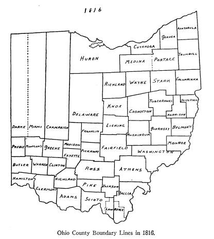
|
wardly with said highlands so far that an east line will strike the beginning. Acts of Ohio, XIII, p. 52. Passed January 4, 1815. |
392 Ohio Arch. and Hist.
Society Publications
Monroe -- March 1, 1815.
This county was organized and extended
by act of
February 3, 1815, to take effect March
1, 1815. Acts
of Ohio, XIII, p. 128.
Huron -- April 1, 1815.
This county was organized and extended
by act of
January 31, 1815, to take effect April
1, 1815. Acts of
Ohio, XIII, p. 113.
Jackson -- March
1, 1816.
All of Scioto, Gallia, Athens and Ross,
beginning at
the northwest corner of T 10, R 17;
east to the north-
west corner of said township; south to
the southeast
corner of T 8, R 17; west to the
southwest corner of
Section 35, T 8, R 17; south to the
southeast corner of
Section 34, T 7, R 17; west to the
southwest corner of T
7, R 17; south to the southeast corner
of T 5, R 18; west
to the southwest corner of Section 33,
T 5, R 19; north
to the northwest corner of Section 4, T
5, R 19; west to
the southeast corner of Pike; north to
the northeast cor-
ner of said county; north to the
northwest corner of T
8, R 19; east to the range line between
R 17 and 18;
north with same line to place of
beginning. Acts of
Ohio, XIV, pp. 112-113. Passed January 12, 1816.
NEW COUNTIES UNORGANIZED
Lawrence -- December 21, 1815.
All of Scioto and Gallia, beginning on
the Ohio at
the southeast corner of T 2, R 15; west
to the southwest
corner of T 2, R 15; north to the
northeast corner of
T 3, R 16; west to the northwest corner
of T 3, R 16;
north to the northeast corner of T 5, R
17; west to range
Evolution of Ohio County
Boundaries 393
line between R 17 and 18; north to the
northeast corner
T 4, R 18; west to the northeast corner
of Section 5,
T 4, R 18; south to the northeast
corner of Section 29,
T 4, R 18; west to the northwest corner
of Section 27,
T 4, R 19; south to the southwest
corner of Section 34,
T 3; west to the northwest corner of
Section 3, T 2, R
19; south to the French Grant Line;
southeastwardly to
the east corner of said Grant; southwestwardly
to the
corner between fractional Sections 3
and 4, T 1; south
to the Ohio; up the river to the place
of beginning. To
be organized when Legislature thinks
fit. Acts of Ohio,
XIV, pp. 22-23. Passed December 21,
1815.
For the boundaries of the French
Grants, see Sher-
man, Ohio Land Subdivisions, Chapter
V.
It should be noted in connection with
the usage of
section numbers in this law that the
numbering of sec-
tions of the land surveyed under the
Ordinance of May
20, 1785, is very different from the
numbering of the
lands surveyed under the law of May 18,
1796. This
difference is shown well in Peters. The
Seven Ranges,
the Ohio Company's Lands, and the
Symmes Purchase
were surveyed and numbered under the
old law. The
rest of the Congress Lands were
numbered according
to the law of 1796.16
CHANGES
Warren from Butler -- March 1, 1815.
All of Butler within fractional T 1 and
2, R 5, and
adjoining the south line of Montgomery,
attached to
Warren. Acts of Ohio, XIII, p.
109. Passed January
30, 1815.
16 Peters, Ohio Lands, pp. 56-61.
394
Ohio Arch. and Hist. Society Publications
This and the following changes of
Clinton, Warren
and Highland all result from the
attempt to give Clinton
its constitutional 400 square miles.
Clinton from Warren -- March
1, 1815.
Eleven square miles of Warren lying
upon the east-
ern boundary of Warren and extending
parallel to the
said eastern boundary of Warren, along
the whole
length of such eastern boundary from
north to south,
attached to Clinton. Acts of Ohio, XIII,
pp. 109-110.
Passed January 30, 1815.
Clinton from Highland -- March 1, 1815.
Three square miles and 18 acres of
Highland at-
tached to Clinton, beginning where the
line, run by the
surveyor of Ross, crosses the east fork
of the Little
Miami, and extending down said east
fork until a line
due west to the line of Clermont,
between Clermont and
Highland, will include in the County of
Clinton, 3 square
miles and 18 acres. Acts of Ohio, XIII,
pp. 110-111.
Passed January 30, 1815.
This revision was necessary because the
southwest
line required to be drawn by the act of
February 4, 1813,
would not allow Clinton its
constitutional 400 square
miles. The line referred to as the line
run by the sur-
veyor of Ross, is the line of the act
of 1813.
This change resulted in a jog in the
line between the
two counties popularly known as the
"Bootleg." It fol-
lowed down the East Fork as far south
as possible and
thence by a due west line extended to
the western bound-
ary of Highland County, which in 1815,
was farther
east than it is today. (The change was
made in 1874,
q. v.)
Evolution of Ohio County
Boundaries 395
Mr. C. Luther Swaim, Prosecuting
Attorney of Clin-
ton County, informs me that he can find
no record of
the original survey of the Bootleg. But
he has found
the record of a re-survey of the
Bootleg made in Sep-
tember, of 1843. He has submitted
copies and blue
prints to me which give the official
information on this
point, as well as on the change of
1874. The records of
this re-survey, (Surveyor's Record No.
2, page 141,
Highland County, Ohio), show that
agreeably to the
order of the Commissioners of Highland
County, Jesse
Barrett, Surveyor of Highland, met
Peyton West, Sur-
veyor of Clinton, and, "not being
able to find any record
of the survey authorized under the
Legislature attaching
three square miles and eighteen acres
of Highland
County to Clinton, we proceeded to make
the survey
agreeably to said act." Then
follows the data describing
the line which I have indicated above.
Although this line
of 1843 was not the original line
drawn, it was drawn, as
the record indicates, on the basis of
the same instruc-
tions because the original records were
lost.
It should be noticed that the west line
of the Bootleg,
as originally formed, was the old line
of Clermont, and
later, of Brown County. The west line
of the Bootleg
today is a mile or so to the east of
the Brown line -- the
change having been caused by the
re-survey of October,
1874, q. v.
Monroe from Washington -- March
1, 1815.
Fractional T 1, R 4, in Washington,
attached to
Monroe. Acts of Ohio, XIII, p.
128. Passed February
3, 1815.
This accompanied the act organizing
Monroe.
|
396 Ohio Arch. and Hist. Society Publications Huron from Delaware -- April 1, 1815. All that part of Ohio lying westwardly of Huron County, northwardly of the south line of the Connecti- cut Western Reserve extending westwardly and east- |
|
|
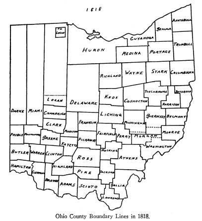
|
wardly of the east line of Champaign, extended due north to the north line of the state, attached to Huron for judicial purposes. Acts of Ohio, XIII, p. 113. Passed January 31, 1815. This accompanied the act organizing Huron. |
Evolution of Ohio County
Boundaries 397
NEW COUNTIES
Darke -- March 1, 1817.
This county was organized by act of
December 14,
1816, to take effect March 1, 1817. Acts
of Ohio, XV,
p. 5.
Lawrence -- March 1, 1817.
This county was organized and extended
by act of
December 20, 1816, to take effect March
1, 1817. Acts
of Ohio, XV, p. 6.
Medina -- January 14, 1818.
This county was organized by act of
January 14,
1818, to take effect immediately. Acts
of Ohio, XVI,
p. 69.
Perry -- March 1, 1818.
All of Washington, Muskingum and
Fairfield, be-
ginning on the line between Licking and
Fairfield at the
northwest corner of T 18, R 17; south
to the southwest
corner of said T 18; east 4 sections to
northwest corner
of Section 2, T 17, R 17; south to
south line of T 17;
east to the southeast corner of T 17;
south to southwest
corner of Section 19, T 14, R 16; east
to southeast cor-
ner of Section 24, T 14; south to
southeast corner of
T 14; east to southeast corner of T 12,
R 14; north to
northeast corner of T 13, R 14; west to
southwest cor-
ner of Section 34, T 14, R 14; north to
northwest corner
of Section 3, T 14, R 14; west to
southwest corner of
Section 35, T 17, R 15; north to
northeast corner of
Section 3, T 17; west to beginning. Acts
of Ohio, XVI,
pp. 26-27. Passed December 26, 1817.
398
Ohio Arch. and Hist. Society Publications
Clark -- March 1, 1818.
All of Champaign, Madison and Greene,
beginning
on the line between Miami and Champaign
on north
boundary of 5th tier of sections in R
10, between Sec-
tions 35 and 36; east to line between
United States Land
and the Virginia Military Land;
eastwardly to line of
Madison; southwardly to point on line
of Madison 6
miles north of southeast corner of
Champaign; diag-
onally so as to intersect the south
line of Champaign 2
miles west of southeast corner of said
county; west with
line of Champaign 1 mile; south 5 1/2
miles into Madi-
son; west to line of Greene; west 5
miles in Greene;
north one-half mile; west to line
between townships 4
and 5, R 8, of the survey between the
Miami Rivers;
north to line between Sections 3 and 4;
west to line of
T 3; north to sectional line between
4th and 5th tier of
sections in R 8; then westwardly to
east line of Mont-
gomery; north to southwest corner of
Champaign; north
with line between Champaign and Miami
line to place of
beginning. Acts of Ohio, XVI,
pp. 33-36. Passed De-
cember 26, 1817.
That part of the south line of Clark,
beginning at a
point five miles west of Greene County
line, and one-half
mile north, "thence west to line
between townships 4
and 5, range 8, in survey between the
Miami Rivers"
cannot be drawn, as such a line west
would go to the
south of the southern end of said line
between the town-
ships 4 and 5. This had to be rectified
by the act of
February 25, 1819.
Brown -- March 1, 1818.
All of Adams and Clermont, beginning at
a point 8
miles west from courthouse in town of
West Union,
Evolution of Ohio County
Boundaries 399
Adams County, north to Highland County
line; west to
Clermont; north to Clinton line; west
so far that a line
running south will strike the Ohio 2
miles above the
mouth of Bullskin Creek; up the Ohio so
far that a due
north line will intersect the
beginning. Acts of Ohio,
XVI, pp. 29-31. Passed December 27,
1817.
In drawing the line between Brown and
Highland,
we must notice that it was originally
drawn farther east
than it is now. The change was made in
1874, q. v.
Logan -- March 1, 1818.
All of Champaign, north of line
beginning on east
line of Miami County between Sections
33 and 34, in T
3, R 13, and running east 12 miles with
sectional line be-
tween 3rd and 4th tier of sections;
south 1 mile; with
sectional line between 2nd and 3rd tier
of sections, R 13,
to line between United States Land and
Virginia Mili-
tary Land; east to line of Champaign;
north to Indian
Boundary Line; west to a point so that
a line drawn
from said point due south will strike
Indian Boundary
Line at point where line between Miami
and Champaign
strikes it; south with Miami-Champaign
line to place of
beginning. Also including the United
States Reserva-
tion at the rapids of the Miami of the Lake;
and juris-
diction shall extend over all territory
lying north of the
county. Acts of Ohio, XVI, pp.
53-55. Passed Decem-
ber 30, 1817.
This act differs from the others in
respect to the in-
clusion of the Indian Lands. A north
line is named and
then it is added that jurisdiction is
to extend over all
land to the north. Hence, I have drawn
the north line
of Logan as a dotted line.
Mr. Peters, in his pamphlet on Ohio's "Lost
Lands,"
400
Ohio Arch. and Hist. Society Publications
writes concerning this change:
"Likewise Champaign
County, created in 1805, and extending
to the north line
of the State, suffered division into
dual parts by the cre-
ation, in 1817, of that part of Logan
County lying south
of the Greenville Treaty Line."17
This statement seems
to overlook the part of the law
creating Logan which
says that jurisdiction shall extend
over all territory
lying to the north of it.
For the location of the United States
Reservation,
see Sherman, pp. 146-150.
Hocking -- March 1, 1818.
All of Ross, Athens and Fairfield,
beginning at
northeast corner of Section 25, T 14, R
16; south to
southeast corner of T 13, R 16; west 3
sections to south-
west corner of Section 13, in T 13, R
16; south to south-
east corner of Section 19, T 11, R 16;
west to southwest
corner of Section 31, T 12, R 17; south
to southeast
corner of Section 36, T 10, R 18; west
to southwest cor-
ner of Section 31, T 10, R 19; north to
northwest corner
of Section 30, T 12, R 19; east to
southeast corner of
Section 24, in T 12, R 19; north to
northwest corner of
Section 18, T 13, R 18; east to
southeast corner of Sec-
tion 12, T 13, R 18; north to northwest
corner of Sec-
tion 18, T 15, R 17; east to northeast
corner of Section
13, in T 15, R 17; south 2 sections to
southeast corner
of Section 24, in R 17; east to
beginning. Acts of Ohio,
XVI, pp. 60-63. Passed January 3, 1818.
For variation in section numbering see
Peters,
Ohio Lands, pp. 56-61.
17 Pamphlet reprint by W. E. Peters,
from Athens Sunday Messenger,
December 21, 1924.
Evolution of Ohio County
Boundaries 401
NEW COUNTIES UNORGANIZED
Morgan --
December 29, 1817.
All of Guernsey, Washington and
Muskingum, be-
ginning at the southwest corner of T 8,
R 13; east to
eastern bank of the Muskingum; down
river to point
where it will intersect north boundary
of Donation
Tract; east with said boundary line to
southeast corner
of T 5, R 9; north to northeast corner
of T 5, R 9; east
to western boundary of Monroe, to
southeast corner of
T 6, R 8; north to northeast corner of
T 7, R 8; west
to line of Muskingum County; south to
southwest cor-
ner of T 8, R 10; west to center of T
14, R 14; south to
south line of said T 14, R 14; east to
southeast corner
of T 14, R 14; south to place of
beginning. To be or-
ganized when Legislature thinks fit. Acts
of Ohio,
XVI, pp. 42-43. Passed December 29,
1817.
For variation in section numbering see
Peters, Ohio
Lands. pp. 50-61.
CHANGES
Franklin from Licking -- January 27, 1817.
Territory contained within the western
half of Sec-
tion 5 and the whole of Section 6, and
in half-sections 7,
8, 9, 28, 29 and 30, of T 16, R 20,
(being a part of what
is commonly called the Canada and Nova
Scotia Refugee
Lands), in Licking, are annexed to
Franklin, and
Township of Plain. Acts of Ohio, XV,
p. 169. Passed
January 27, 1817.
This change can be seen best by a
reference to Sher-
man's large-scale map accompanying his
report. From
this, it will be seen that the sections
in the townships of
this tract are formed and numbered
differently from the
Vol. XXXVI--26
402 Ohio Arch. and Hist. Society Publications
usual method. The northern tier of
sections is made up
of sections 1 mile square and are
numbered 1 to 6 be-
ginning at the northeast. The rest of
the sections are
really not sections but as the above
statute says, "half
sections," rectangular strips 1
mile north and south,
one-half mile east and west. However,
each half-section
is numbered from 7 upward. Peters, in
his map of the
Refugee Tract, p. 286 of Ohio Lands,
has made the sec-
tions full ones and has numbered them
accordingly. He
has thus ignored the provisions in the
act of February
18, 1801, which set aside this Grant
which directed the
sections to be subdivided into 320-acre
lots by halving
each whole section with a north and
south line.18
Lawrence from Scioto -- March 1, 1817.
Such part of fractional T 1, R 19, as
lies above the
French Grant in Scioto County, attached
to Lawrence.
Acts of Ohio, XV, pp. 6-7. Passed December 20, 1816.
Jackson from Ross -- March 1, 1817.
All of Ross comprised within T 9, R 18,
and T 9,
R 19, of the United States Land,
attached to Jackson.
Acts of Ohio, XVI, pp. 62-63. Passed January 3, 1818.
This change was part of the act
creating Hocking.
Madison from Champaign -- March 1, 1818.
All of Champaign, east of eastern
boundary of
Clark, attached to Madison. Acts of
Ohio, XVI, pp.
75-76. Passed January 16, 1818.
It will be noted that, in the formation
of Clark
County, the eastern line took away part
of Madison. It
18 Sherman, Ohio Land Subdivisions, p.
119.
Evolution of Ohio County
Boundaries 403
also left an irregular tract of
Champaign to the west of
Madison.
Scioto from Lawrence -- March 1, 1818.
All of Lawrence in T 3 and 4, of R 19,
attached to
Scioto. Acts of Ohio, XVI, p.
77. Passed January 20,
1818.
Lawrence from Gallia -- December 22, 1818.
All of Gallia, contained in second
fractional town-
ship, R 15, attached to Lawrence. Acts
of Ohio, XVII,
pp. 3-4. Passed December 22, 1818.
NEW COUNTIES
Morgan -- March 1, 1819.
This county was organized by act of
December 28,
1818, to take effect on March 1, 1819. Acts
of Ohio,
XVII, p. 7.
Shelby -- April 1, 1819.
All of Miami lying north of line
beginning on line
between Miami and Darke between
Sections 27 and 34,
T 10, R 4, and east to Great Miami
River; across said
river; down river to middle of R 12, T
1, east of Miami
River, to section line between Sections
21 and 22; east
to Champaign line; north with said line
dividing Miami,
Champaign and Logan to Indian Boundary
Line; north
6 miles; west to a point so that a line
drawn from it due
south will strike Indian Boundary Line
at the point
where line between Miami and Darke
strikes said line;
south with line to beginning--also
including the United
States Reservations at Forts St.
Mary's, Amanda and
|
404 Ohio Arch. and Hist. Society Publications Defiance. Jurisdiction to extend over all country north of said county and at this time included in Miami. Acts of Ohio, XVII, pp. 21-23. Passed January 7, 1819. |
|
|
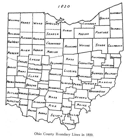
|
The original extent of Shelby to include all north to the state line is not shown, due to the fact that our own map of 1820 shows its inclusion in the counties formed in 1820. For Forts St. Mary's, Amanda and Defiance. see Sherman, Plate 29. |
Evolution of Ohio County
Boundaries 405
Meigs -- April 1, 1819.
All of Gallia and Athens, beginning on
bank of the
Ohio, on sectional line between R 13
and 14; north to
southeast corner of Section 6, T 5, R
14; west to south-
west corner of Section 36, T 7, R 15;
north to north-
west corner of Section 36, T 9, R 15;
east to Ohio River
and down to beginning. Acts of Ohio,
XVII, pp. 41-43.
Passed January 21, 1819.
Union -- April 1, 1819.
All of Delaware, Franklin, Madison and
Logan and
north of old Indian Boundary Line,
beginning on north
boundary line of Delaware on that part
known by name
of old Indian or Greenville Line, at
point 3 miles west of
Scioto River; south 15 miles; east 4
miles; south to
north boundary of Franklin; south 2 1/2
miles into Frank-
lin; west to east boundary of Madison
and to continue
west to east boundary of Champaign;
north to northeast
corner of said county; west 3 miles;
north so far that a
due east line will strike a point 3
miles north of begin-
ning; south to beginning. Acts of
Ohio, XVIII, pp.
56-57. Passed January 10, 1820.
Sandusky -- April 1, 1819.
The tenth county formed from the Indian
Lands is
to include all of Ranges 13, 14, 15, 16
and 17 north of
3rd tier of townships north and east of
the First Princi-
pal Meridian. Acts of Ohio, XVIII,
p. 90. Passed Feb-
ruary 12, 1820.
By a treaty at Fort Meigs, September
29, 1817, the
Indian Country in northwest Ohio, with
the exception
of about 300,000 acres and nine
reservations, was ceded
to the United States. See Sherman, pp.
136-137 and
406
Ohio Arch. and Hist. Society Publications
Plate 29. By the act of the Ohio
Legislature of Febru-
ary 12, 1820, taking effect April 1,
1820, this region was
divided into fourteen counties, only
two of which, San-
dusky and Wood, were immediately
organized. The
rest were attached temporarily to
counties already or-
ganized.
The townships were surveyed and laid
off from the
bases of the west line of the State,
namely the First
Principal Meridian, and the line of the
forty-first par-
allel of latitude, as nearly as it
could be determined at the
time.19 All points to the
north of this line were referred
to as north and east, and those to the
south, as south
and east.
Seneca was attached to Sandusky until
the former
was organized.
Wood -- April 1, 1820.
The eleventh county formed from the
Indian Lands
is to include all of Ranges 9, 10, 11
and 12, north of the
2nd tier of townships, north, in said
ranges, and to run
north with same to state line. Acts
of Ohio, XVIII, p.
90. Passed February 12, 1820.
The counties of Hancock, Henry, Putnam,
Paulding
and Williams were attached to Wood
until they should
be organized.
NEW COUNTIES UNORGANIZED
Van Wert -- April 1, 1820.
The first county formed from the Indian
Lands is
to include T 1, 2 and 3, south, R 1, 2,
3 and 4, and is to
be attached to Darke until organized. Acts
of Ohio,
XVIII, p. 90. Passed February 12, 1820.
19 Sherman, Ohio Land Subdivisions, p.
131. Plates 30 and 31.
Evolution of Ohio County
Boundaries 407
Mercer -- April 1, 1820.
The second county formed from the
Indian Lands
is to include all of Ranges 1, 2, 3 and
4, south, of said
township in Van Wert, to the northern
boundaries of
counties already organized. Attached to
Darke until or-
ganized. Acts of Ohio, XVIII, p.
90. Passed February
12, 1820.
Putnam -- April
1, 1820.
The third county formed from the Indian
Lands is
to include T 1 and 2, south, and 1 and
2, north, R 5, 6, 7
and 8, and to be attached to Wood until
organized.
Acts of Ohio, XVIII, p. 90. Passed February 12, 1820.
Allen -- April 1, 1820.
The fourth county formed from the
Indian Lands is
to include Ranges 5, 6, 7 and 8, south,
townships num-
bered 2, to the northern boundaries of
organized coun-
ties. To be attached to Shelby until
organized. Acts
of Ohio, XVIII, p. 90. Passed February 12, 1820.
Hancock -- April 1, 1820.
The fifth county formed from the Indian
Lands is to
include T 1 and 2, south, and 1 and 2,
north, in Ranges
9, 10, 11 and 12, and to be attached to
Wood until or-
ganized. Acts of Ohio, XVIII, p.
90. Passed Febru-
ary 12, 1820.
Hardin -- April 1, 1820.
The sixth county formed from the Indian
Lands is
to include Ranges 9, 10, 11 and 12,
south, of said town-
ships numbered 2, and running south
with range lines
to northern boundaries of counties
organized. To be
408
Ohio Arch and Hist. Society Publications
attached to Logan until organized. Acts
of Ohio,
XVIII, p. 90. Passed February 12, 1820.
Crawford -- April 1, 1820.
The seventh county formed from the
Indian Lands
is to include T 1, 2 and 3, south, R
13, 14, 15, 16 and 17,
and all that may lie between same and
west line of Rich-
land. To be attached to Delaware until
organized.
Acts of Ohio, XVIII, p. 90. Passed February 12, 1820.
The eastern part of Crawford included
part of the
Indian Lands, ceded at Fort Industry,
in 1805, not in-
cluded in Richland County. See Sherman,
Plate 29.
Marion -- April 1, 1820.
The eighth county formed from the
Indian Lands is
to include R 13, 14, 15, 16 and 17,
south, of townships
numbered 3, to run south with said
range lines to north-
ern boundaries of organized counties
and east with said
township lines to Richland County line.
To be attached
to Delaware until organized. Acts of
Ohio, XVIII, p.
90. Passed February 12, 1820.
Seneca -- April 1, 1820.
The ninth county formed from the Indian
Lands is
to include T 1, 2 and 3, north, R 13,
14, 15, 16 and 17,
and to be attached to Sandusky until
organized. Acts
of Ohio, XVIII, p. 90. Passed February 12, 1820.
The following quotation from Peters
will explain a
glaring discrepancy in the present
boundary between
Seneca and Huron: "When the west
line of the Con-
necticut Reserve was run to the north
it was diverged to
the west so as to include, it is said,
the 'Blue Hole,' at
Castalia. Later the Federal Government
subdivided all
Evolution of Ohio County
Boundaries 409
the land lying between the Reserve and
the west line of
the state into ranges and townships.
The ranges, of
which there were eighteen, were
numbered east from
the Indian Line, while the townships
were numbered
north from the forty-first parallel of
latitude. All
ranges, including the seventeenth, were
full six miles
wide, but the eighteenth range, lying
immediately west
of the Reserve, was but fifty-two
chains wide at the
south end and converged to a point
about eighteen miles
to the north, and constituted the
'Gore.'
"In 1809, when correcting the
uncertain description
of Franklin County, all land lying
north of the Green-
ville Treaty Line was added to Delaware
County, where
it remained until 1820, when Seneca County
was created
of 'townships one, two and three,
north, in ranges thir-
teen, fourteen, fifteen, sixteen and
seventeen,' thus fail-
ing to include the eighteenth range, or
the 'Gore' which
yet remains a part of Delaware
County."20 I have shown
this only on the map of 1820.
It seems, however, that the Gore
belongs to Huron
rather than to Delaware, because the
Act of January 31,
1815, organizing Huron, said that all
that part of Ohio
lying west of Huron, north of the south
line of the Re-
serve extended west to Champaign, was
to be attached
to Huron for judicial purposes. This
included the Gore.
Henry -- April 1, 1820.
The twelfth county formed from the
Indian Lands
is to include all of R 5, 6, 7 and 8,
north, of T 2, north,
in said Ranges and to run north with
same to state line.
20 Reprint by W. E. Peters, from Athens,
Ohio, Sunday Messenger,
December 21, 1924.
410
Ohio Arch. and Hist. Society Publications
To be attached to Wood until organized.
Acts of Ohio,
XVIII, p. 90. Passed February 12, 1820.
Paulding -- April 1, 1820.
The thirteenth county formed from the
Indian
Lands is to include T 1, 2 and 3,
north, in Ranges 1, 2, 3
and 4. To be attached to Wood County
until organized.
Acts of Ohio, XVIII, p. 90. Passed February 12, 1820.
Williams -- April 1, 1820.
The fourteenth county formed from the
Indian
Lands is to include all of Ranges 1, 2,
3 and 4, north, of
townships numbered 3, north, in said
ranges, to run with
same to state line. To be attached to
Wood until or-
ganized. Acts of Ohio, XVIII, p.
90. Passed February
12, 1820.
CHANGES
Clark-Greene Line Changed -- February 25, 1819.
Whereas, by act of December 26, 1817,
the line be-
tween Greene and Clark will not run to
those points,
therefore, line shall run from Greene
County line where
it first strikes said county line; west
5 miles in Greene;
north one-half mile; west so as to
strike the line be-
tween T 4 and 5 on the north side of
Little Miami in
R 8; north with said township line to
line between Sec-
tions 3 and 4; west with said sectional
line to line of
third township; north to sectional line
between 4th and
5th tier of sections in said range;
westwardly with said
line to east boundary of Montgomery. Acts
of Ohio,
XVII, pp. 60-61. Passed February 25,
1819.
Evolution of Ohio County
Boundaries 411
Monroe from Morgan -- December 24, 1819.
All of Morgan as contained in T 6 and
7, R 8, at-
tached to Monroe. Acts of Ohio, XVIII,
p. 4. Passed
December 24, 1819.
Logan from Indian Country -- April 1, 1820.
Territory north of Logan contained in
following --
beginning at northeast corner of Logan,
running north
5 miles; west to a point from which a
south line will
strike the northwest corner of said
county; south to said
corner; east with line to beginning -- shall
be attached to
Logan County. Acts of Ohio, XVIII,
p. 58. Passed
January 10, 1820.
This change was part of the act forming
Union
County.
Madison from Franklin -- April 1, 1820.
All of Franklin within following --
beginning on
line between Franklin and Madison at
point 2 1/2 miles
south of north boundary of said county;
east 2 miles;
south 4 miles; west 2 miles; north to
place of beginning
-- shall be attached to Madison. Acts
of Ohio, XVIII,
pp. 58-59. Passed January 10, 1820.
This change was also part of the act
forming Union
County.
NEW COUNTIES UNORGANIZED
Lorain -- December 26, 1822.
All of Huron east of R 20, and all of
Cuyahoga west
of R 15, with T 5, and west half of T
6. R 15. and fol-
lowing townships and territory from
Medina: T 4, R
17, T 3 and 4, R 18, and all of R 19,
north of a line run-
ning from southwest corner of T 3, R
18, west to R 20
|
412 Ohio Arch. and Hist. Society Publications -- to be organized when Legislature sees fit. O. L. L.,* XXI, p. 5. Passed December 26, 1822. |
|
|
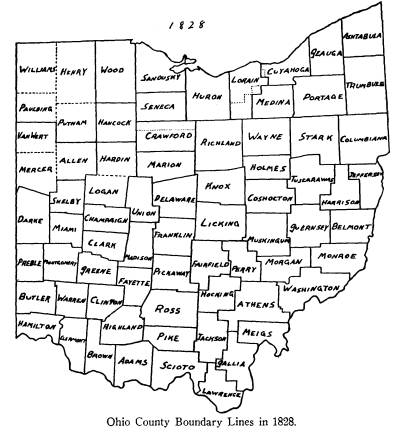
|
The part of Lorain attached to Cuyahoga by the act of January 29, 1827, and the parts of Medina attached to Lorain by the same act, are shown in dotted lines. Thus the original boundaries of Lorain as described above are shown partly by dotted lines. * The Ohio Local Laws are frequently referred to hereafter by the abbreviation O. L. L. |
Evolution of Ohio County
Boundarics 413
Holmes -- January 20, 1824.
All of Coshocton, Tuscarawas and Wayne,
begin-
ning on old Indian Boundary Line, where
east boundary
of Wayne intersects; north to northeast
corner of Sec-
tion 25, T 15, R 11; west on section
lines to west bound-
ary of Wayne; south to old Indian
Boundary Line, to
northeast corner of Knox; south to line
between T 7 and
8; east to southeast quarter of Section
24, T 8, R 4;
north to aforesaid Indian Boundary Line;
thence to
place of beginning. O. L. L., XXII,
p. 50. Passed Jan-
uary 20, 1824.
NEW COUNTIES
Mercer -- January 2, 1824.
Mercer was organized by act of the
above date to
take effect immediately. O. L. L., XXII,
p. 41. Van
Wert was attached for judicial
purposes.
Williams -- February 2, 1824.
Williams was organized by act of the
above date to
take effect immediately. O. L. L., XXII,
p. 19. Pauld-
ing, Henry and Putnam were attached for
judicial pur-
poses.
Lorain -- April 1, 1824.
Lorain was organized by act of January
21, 1824, to
take effect April 1, 1824. O. L. L.,
XXII, p. 12. This
county was erected by act of December
26, 1822. See
"New Counties Unorganized."
However, it remained
unorganized until the above date.
Seneca -- April 1, 1824.
Seneca was organized by act of January
22, 1824,
to take effect April 1, 1824. O. L.
L., XXII, p. 40. The
414
Ohio Arch. and Hist. Society Publications
northern tier of sections in Crawford
was attached to
Seneca for judicial purposes by act of
February 17,
1824. See "Changes."
Marion -- May 1, 1824.
Marion was organized by act of December
15, 1823,
to take effect May 1, 1824. O. L.
L., XXII, p. 48.
Crawford was attached for judicial
purposes.
Holmes -- January 4, 1825.
Holmes was organized by act of the
above date to
take effect immediately. Ohio
General Laws, XXIII, p.
21. It was erected by act of January
20, 1824. See
"New Counties Unorganized."
However, it remained
unorganized until the above date.
Crawford -- April 1, 1826.
Crawford was organized by act of
January 31, 1826,
to take effect April 1, 1826. O. G.
L.,* XXIV, p. 46.
Hancock -- March 1, 1828.
Hancock was organized by act of January
21, 1828,
to take effect March 1, 1828. O. G.
L., XXVI, p. 5.
CHANGES
Van Wert Attached to Mercer -- January 2, 1824.
When Mercer was organized, Van Wert was
de-
tached from Darke and attached to Mercer.
O. L. L.,
XXII, p. 41.
Paulding, Henry and Putnam Attached
to Williams --
February 2, 1824.
With the organization of Williams the
above three
counties were detached from Wood and
attached to
Williams. O. L. L., XXII, p. 19.
* Ohio General Laws.
Evolution of Ohio County
Boundaries 415
Crawford, Part Attached to Seneca --
February 17,
1824.
All of Crawford north of Wyandot
Reservation, in-
cluding first tier of townships, east
and west, attached to
Seneca for judicial purposes until
Crawford is organ-
ized. O. L. L., XXII, p. 88.
This change is shown in the map by
dotted lines.
For the location of the Wyandot
Reservation, see Sher-
man, Ohio Land Subdivisions, Plate
29.
Crawford, Part Attached to Marion --
May 1, 1824.
When this act was passed, December 15,
1823, (O. L.
L., XXII, p. 48), the terms of the act included all of
Crawford, but before it went into
effect on May 1, 1824,
the above stated act of February 17,
1824, was passed
attaching the northern tier of sections
in Crawford to
Seneca.
Scioto from Lawrence -- March 1, 1826.
All of Lawrence, beginning at the
northeast corner
of Section 29, T 4, R 18, running south
to southeast cor-
ner of Section 5, T 3, R 18; west to
southwest corner
of Section 6, in T and R aforesaid,
attached to Scioto.
O. L. L., XXIV, p. 76. Passed January 31, 1826.
Mercer from Shelby -- March 1, 1826.
All of Shelby north of south boundary
of T 7, south
of base line, in R 4, east of First
Meridian, attached to
Mercer. O. L. L., XXIV, p. 62.
Passed February 3,
1826.
Clark-Madison Line Changed -- January 22, 1827.
Line between above named counties to be
as follows
-- beginning at northeast corner of
Clark, thence to a
416
Ohio Arch. and Hist. Society Publications
point so far east of southeast corner
of county as will
leave as much land in Clark as shall be
taken by Madi-
son. O. G. L., XXV, p. 24.
Passed January 22, 1827.
Lorain from Medina -- January 29, 1827.
All of Medina west of R 16, together
with T 4, R 16,
attached to Lorain. O. G. L., XXV,
p. 111. Passed
January 29, 1827.
Cuyahoga from Lorain -- January 29, 1827.
All of T 6, R 16, of Lorain, attached
to Cuyahoga
and shall be part of Township of
Middlebury, until oth-
erwise provided for. O. G. L., XXV.,
p. 111. Passed
January 29, 1827.
It is apparent that a misprint has been
made in the
drawing up of this law. By the act of
December 26,
1822, creating Lorain, it was made to
include all west of
Range 15 and Township 5, and the west
half of Town-
ship 6, of Range 15. The intent was
undoubtedly that
all that part -- west half of Township 5, Range 15 in
Lorain -- be attached to Cuyahoga. But
as it reads, all
of Township 5, Range 16, belongs to
Cuyahoga instead
of Lorain, and the west half of
Township 5, Range 15,
belongs to Lorain instead of Cuyahoga.
This situation
is verified by Mr. C. H. Hutchinson, of
the Engineer's
and Surveyor's Office of Cuyahoga
County, and by Mr.
W. E. Peters.
Portage from Medina -- January 29, 1827.
The line between Portage and Medina is
redefined
as follows: Beginning on south line of
Connecticut
Western Reserve at a point where the
middle of Tusca-
rawas River intersects the same,
northerly, following
Evolution of Ohio County
Boundaries 417
middle of river to range line between R
11 and 12, as
run by Connecticut Land Company; north
on said range
line, to north line of townships
numbered 3; north on
range line aforesaid to north line of T
4; east on north
line of number 4, in R 11, to middle of
Cuyahoga River;
down middle of said river to north line
of T 5 in said
ranges. O. L. L., XXV, p. 112.
Passed January 29,
1827.
By this act the line between Portage
and Medina,
which was stated in the act erecting
Medina, February
18, 1812, to be the west line of Range
11, is redefined so
that a small part of Medina, west of
the above Range
line and east of the Tuscarawas River,
is added to Por-
tage.
Allen Attached to Mercer -- March 1, 1828.
This act, by which Allen was detached
from Shelby
and attached to Mercer, was passed
January 5, 1828, to
take effect March 1, 1828. O. G. L.,
XXVI, p. 1.
NOTES
1. The act of January 29, 1827,
readjusting the
boundaries of certain of the Reserve
Counties, extended
the lines of the lake counties from the
shore of Lake
Erie to the north boundary of the
United States in Lake
Erie. I have not shown these on the
map.
2. The creation of Union County, in
1820, made it
necessary for many laws to be passed
between 1820 and
1827, regarding how the lines of
Madison, Union, Lo-
gan and Champaign should be surveyed.
But since
there was no change made by these acts
in the lines as
recorded in this work, I have not
attempted to reproduce
these surveyors' adjustments.
Vol. XXXVI--27.
|
418 Ohio Arch. and Hist. Society Publications NEW COUNTIES UNORGANIZED Erie -- March 15, 1838. All of Huron and Sandusky, beginning at a point on east line of Oxford Township, Huron County, one |
|
|
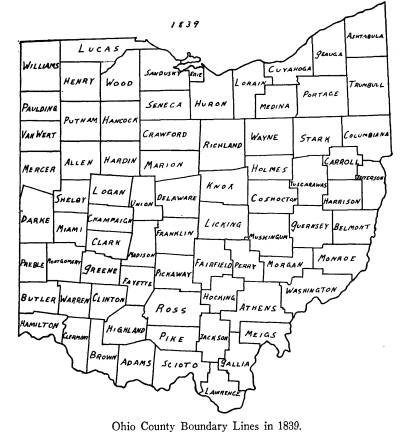
|
mile north of southeast corner thereof; north to Canada line; westerly to point directly opposite west line of Portage Township, in Sandusky County; southerly par- allel to east line of Sandusky County, to northwest cor- ner of Townsend Township, in Sandusky County; east |
Evolution of Ohio County
Boundaries 419
to west boundary of Huron; south to
point one mile
north of south line of Groton Township
in Huron;
thence to beginning. To include
Cunningham's (or
Kelly's) Island. O. G. L., XXXVI,
p. 60. Passed March
15, 1838.
One would be inclined to doubt the
accuracy of my
original drawing of Erie due to its
smallness. The only
way by which its boundaries on the
mainland could be
interpreted as being larger, would be
by assuming that
the northwest corner of the Township of
Townsend, in
1838, was farther north and west than
the point I have
taken, namely, the southeast corner of
Township 6,
Range 16, north, and east of the First
Principal Merid-
ian. However, it could not have been
northwest of the
point assumed, because the act of March
6, 1840, desig-
nates the same point, southeast corner
of Bay Town-
ship, as the beginning point of Ottawa
County. It could
not be due west in Sandusky County
because there is no
subsequent act transferring any part of
Erie to San-
dusky.
The eastern boundary could not be any
farther east
because the same act, which created
Ottawa on March
6, 1840, also added to Erie the
Townships of Milan, Hu-
ron, Berlin, Florence and Vermilion,
which comprise
all the territory east of the eastern
boundary as shown.
NEW COUNTIES
Allen -- March 1, 1831.
Allen was organized by act of February
9, 1831, to
take effect on March 1, 1831. O. L.
L., XXIX, p. 94.
420
Ohio Arch. and Hist. Society Publications
Carroll -- January
1, 1833.
All of Columbiana, Stark, Tuscarawas,
Harrison and
Jefferson, beginning at the southeast
corner of Section
1, T 13, R 4, in Columbiana; north 6
miles to northeast
corner of Section 6, T 13, R 4; west 3
miles to northwest
corner of Section 18, T 13, R 4; north
6 miles to north-
east corner of Section 4, T 14, R 4;
west 17 miles to
northwest corner of Section 2, T 17, R
7, in Stark; south
between 5 and 6 miles to southwest
corner of Section 26,
T 17, R 7; west 4 miles to northwest
corner of Section
36, T 16, R 7; south 6 miles to
southwest corner of Sec-
tion 31, T 16, R 7; east 3 miles to
northwest corner of
Section 18, T 15, R 7, in Tuscarawas;
south 9 miles to
southwest corner of Section 16, T 14, R
7; east 17 miles
to southeast corner of Section 28, T
11, R 4, in Jefferson;
north 3 miles to northeast corner of
Section 30, T 11,
R 4; east 1 mile to northeast corner of
Section 24, T 11,
R 4; north 6 miles to northeast corner
of Section 24, T
12, R 4; east 3 miles to place of
beginning. O. G. L.,
XXXI, pp. 8-9. Passed December 25,
1832.
For variation in section numbering, see
Peters, Ohio
Lands, pp. 56-61.
Hardin -- March 1, 1833.
Hardin was organized by act of January
19, 1833, to
take effect March 1, 1833. O. L. L.,
XXXI, p. 10.
Putnam -- January 3, 1834.
Putnam was organized by act of above
date to take
effect immediately. O. L. L., XXXII,
p. 19.
Henry -- December
26, 1834.
Henry was organized by act of above
date to take
effect immediately. O. L. L. XXXIII,
p. 11.
Evolution of Ohio County
Boundaries 421
Lucas -- June 20, 1835.
All of Sandusky, Wood and Henry,
beginning at a
point on Lake Erie where line, commonly
called Fulton's
Line, intersects same; west to Maumee
River; south-
westerly with river to point where
township line between
T 6 and 7, if drawn and continued
across the twelve-
mile-square reservation, would
intersect same; west to
county line between Henry and Williams;
north to
northern boundary line of State, called
Harris's Line;
east to Lake Erie; to place of
beginning. O. L. L.,
XXXIII, pp. 5-7. Passed June 20, 1835.
The dotted line shows part of the
original Lucas line
as it existed before the change of
March 14, 1836.
Van Wert -- March 18, 1837.
Van Wert was organized by act of above
date to take
effect immediately. O. L. L., XXXV,
p. 273.
Erie -- March 16, 1838.
Erie was organized, by act of above
date, to take ef-
fect immediately the day after it was
passed erecting it.
O. G. L., XXXVI, p. 66.
Paulding -- March 18, 1839.
Paulding was organized by act of above
date to take
effect immediately. O. L. L., XXXVII,
p. 385.
CHANGES
Jefferson from Columbiana -- January
1, 1833.
All of Columbiana, beginning at
northeast corner of
Section 3, T 13, R 4; east 6 miles to
northeast corner
of Section 3, T 12, R 3; south one mile
to southeast cor-
ner of Section 3, T 12, R 3; due east
to the Ohio; down
422
Ohio Arch. and Hist. Society Publications
river to termination of eastern
boundary of Jefferson;
west along present boundary between
Counties of Co-
lumbiana and Jefferson to southeast
corner of Section
1, T 13, R 4; north to place of
beginning. O. G. L.,
XXXI, p. 8. Passed December 25, 1832.
This was part of the act creating
Carroll County.
Harrison from Tuscarawas -- January
1, 1833.
All of Tuscarawas, beginning at
southwest corner of
Section 16, T 14, R 7; south 9 miles to
north boundary
line of T 12, R 7; east 3 miles to the
northwest corner of
T 11, R 6; north 6 miles with township
line to the north-
west corner of T 12, R 7; east by the
township line 3
miles; north 3 miles to the southwest
corner of Section
16, T 13, R 6; west 6 miles to place of
beginning -- at-
tached to Harrison. O. G. L., XXXI,
pp. 88-89. Passed
December 25, 1832.
This was also part of the act creating
Carroll
County.
Carroll, North Line Revised -- February 3, 1834.
Line to be as follows -- beginning at
northeast cor-
ner of Section 4, T 14, R 4; thence
west on township
line, as known and now existing on the
north of East
or Old Franklin, Augustin, and Brown to
the north-
west corner of Brown Township; south to
the northeast
corner of Sandy Township; west to the
northwest cor-
ner of Section 2, T 17, R 7; south
between 5 and 6 miles
to the southwest corner of Section 26,
in T 17, R 7; all
residue of said county lines shall
remain as designated
by act to which this is an amendment. O.
L. L., XXXII,
p. 50. Passed February 3, 1834.
Evolution of Ohio County
Boundaries 423
The north line of Carroll, by act of
December 25,
1832, was made to run west 17 miles
from the northeast
corner of Section 4, T 14, R 4, to the
northwest corner
of Section 2, T 17, R 7. There is a jog
in the section
lines between R 6 and 7 in this region,
and the above
line, disregarding that jog, would cut
through the town-
ships named in the above act. Hence
this act provides
for the jog.
Ross from Hocking -- March 1, 1834.
So much of T 10, R 19, in Hocking,
beginning at
southwest corner of Hocking; east 6
miles with county
line to the township line; north 5
miles with township
line to sectional line; west 6 miles
with sectional line to
county line; south 5 miles to place of
beginning. O. L.
L., XXXII, p. 240. Passed March 1, 1834.
Lucas from Wood -- March 14, 1836.
Boundary as follows -- beginning at a
point in Lake
Erie where Fulton's Line intersects
same; west to Mau-
mee River; southwesterly to east line
of Henry; north to
northeast corner of T 6, R 8; west to
east line of Wil-
liams; north to north boundary of
state--Harris's Line;
easterly to Lake Erie; due east till
line drawn due north
from beginning will intersect. O. L.
L., XXXIV, p.
470. Passed March 14, 1836.
Perry from Licking -- February 20, 1837.
All of Licking in the south half of
Sections 17 and
18, in T 19, R 17, of the Refugee
Lands, to be attached
to Thorn Township in Perry County. O.
L. L., XXXV,
p. 97. Passed February 20, 1837.
|
424 Ohio Arch. and Hist. Society Publications Ross from Jackson -- January 11, 1839. Sections 6 and 7, in T 9, R 19, in Jackson, to be at- tached to Ross County, as part of Eagle Township. O. L. L., XXXVII, p. 18. Passed January 11, 1839. |
|
|
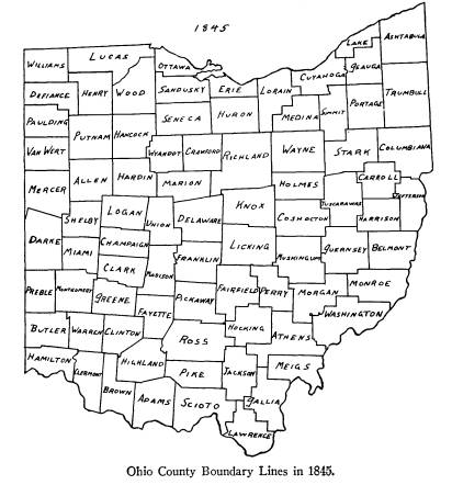
|
Gallia from Lawrence -- April 1, 1839. Sections 1 and 2, in T 5, R 17, in Lawrence County, to be attached to Township of Walnut, in Gallia County. O. L. L., XXXVII, p. 229. Passed March 15, 1839. |
Evolution of Ohio County
Boundarics 425
NEW COUNTIES UNORGANIZED
Summit -- March 3, 1840.
All of Portage, Medina and Stark,
beginning at the
northwest corner of Portage; east to
northeast corner
of Twinsburg Township, in Portage;
south to the south-
east corner of Springfield Township in
said county;
west to northeast corner of Green
Township, in Stark;
south to southeast corner of same; west
to southwest
corner of Franklin Township; north to
south line of Me-
dina; west to southwest corner of
Norton Township, in
Medina; north to northwest corner of
Richfield Town-
ship in said county; east to southwest
corner of North-
field Township, in Portage; north to
place of beginning,
and to restore to Medina its
constitutional limits, the
Townships of Spencer and Homer, in
Lorain County,
are attached to Medina. O. L. L., XXXVIII,
p. 88.
Passed March 3, 1840.
Lake -- March 6, 1840.
All of Geauga and Cuyahoga, beginning
at the
southwest corner of Willoughby
Township, in Cuya-
hoga; east to southeast corner of
Kirtland Township, in
Geauga; north to southwest corner of
Concord Town-
ship; east to southwest corner of
Thompson Township;
north to line between T 10 and 11 in
Thompson Town-
ship; east to county line of Geauga;
north to Canada
line; west along said line to point
directly opposite west
line of Willoughby Township, in
Cuyahoga; south to
place of beginning. O. L. L., XXXVIII,
p. 102. Passed
March 6, 1840.
426
Ohio Arch. and Hist. Society Publications
NEW COUNTIES
Ottawa -- March 6, 1840.
North part of Sandusky and Erie and
eastern part
of Lucas, beginning at a point 2 miles
north of south-
east corner of T 16, called Bay
Township, Sandusky
County; west on section lines to
western line of said
county; north to Lucas County line;
east 6 miles; north
till it intersects Michigan line; with
said line until it
intersects the line between the British
and American
Governments in Lake Erie; down Lake
with said line,
so that a line to mouth of Sandusky Bay
will include
Cunningham's Island; up the Bay to
place of beginning.
O. L. L., XXXVIII, p. 99. Passed March 6, 1840.
Summit -- March 17, 1840.
Summit was organized by act of above
date, to take
effect immediately. O. L. L., XXXVIII,
p. 150.
Lake -- March 20, 1840.
Lake was organized by act of above
date, to take
effect immediately. O. L. L., XXXVIII,
p. 171.
Wyandot -- February 3, 1845.
All of Crawford, Marion, Hardin and
Hancock,
beginning at the southeast corner of
Section 10, T 4,
south, R 15, of public survey of lands
in Marion; north
on sectional lines through Crawford, to
north line there-
of, between Sections 2 and 3, T 1,
south, R 15, which
line shall form east boundary of
Wyandot and west line
of Crawford; west on base line to
northwest corner of
Section 2, T 1, south, R 12, in
Hancock; south on sec-
tional line to northeast corner of
Section 22 in said
township and range; west on section line
to northwest
Evolution of Ohio County
Boundaries 427
corner of Section 22; south on
sectional line to south
line of said township as originally
surveyed, between
Sections 33 and 34; west on said
township line to north-
west corner of Section 5, T 2, south, R
12; south on
sectional line through said T 2 to
south line thereof, at
northwest corner of Section 5, T 3,
south, R 12, in
Hardin; east to northeast corner of
said Section 5;
south on sectional line to southwest
corner of Section 9,
T 4, south, R 12; east to northwest
corner of Section 13
in township and range last aforesaid;
south to south-
west corner of Section 13; east on
sectional line to
southeast corner of Section 13, T 4,
south, R 13; north
to northeast corner of Section 13
aforesaid; east on sec-
tional line to place of beginning. O.
L. L., XLIII, p.
61. Passed February 3, 1845.
Defiance -- April 7, 1845.
All of Williams, Henry and Paulding,
beginning on
Indiana state line, where line between
T 5 and 6, north,
in Williams County, intersects said
state line; east on
township line to east line of R 5;
south on range line to
north line of Putnam; west on Putnam
County line to
east line of Paulding; north to point
where section line
between Sections 13 and 24, T 3, north,
R 4, east,
intersects said county line; west to
west line of said
township; north to present south line
of Williams; west
to Indiana state line; north to place
of beginning. O.
L. L., XLIII, pp. 191-192. Passed March 4, 1845.
CHANGES
Lawrence from Gallia -- February 11, 1840.
Section 2, T 5, R 7, in Gallia,
mentioned in act en-
titled, "Act to attach a part of
the County of Lawrence
428
Ohio Arch. and Hist. Society Publications
to the County of Gallia," passed
March 15, 1839, is here-
by attached to Lawrence, as it was
before passage of
above act. O. L. L., XXXVIII, p. 46.
Passed February
11, 1840.
Gallia from Lawrence -- February 11, 1840.
Section 12, T 5, R 7, in Lawrence,
hereby attached to
Walnut Township in Gallia County. O. L.
L. XXXVIII,
p. 46. Passed February 11, 1840.
Medina from Lorain -- March 3, 1840.
To restore to Medina County its
constitutional lim-
its, the Townships of Spencer and
Homer, in Lorain,
are attached to Medina. O. L.
L., XXXVIII, p. 88.
Passed March 3, 1840.
This change was part of the act
erecting Summit
County.
Erie from Huron -- March 6, 1840.
All territory now in Huron, north of
the north line of
Townships of Wakeman, Townsend,
Norwalk, Ridge-
field and Lyme, which includes the
Townships of Ver-
milion, Florence, Berlin, Milan and
Huron, and also a
strip from off the south side of the
Townships of Oxford
and Groton, one mile in width, be
hereby attached to
Erie County. O. L. L., XXXVIII,
p. 100. Passed
March 6, 1840.
Sandusky from Ottawa -- March 23, 1840.
All of Clay Township in Ottawa,
beginning at south-
west corner of Section 23; north to
northwest corner of
Section 11; west to Wood County line,
is hereby at-
tached to Sandusky. O. L. L., XXXVIII, p. 201.
Passed March 23, 1840.
Evolution of Ohio County
Boundaries 429
Geauga from Cuyahoga -- January 29, 1841.
All of Township of Orange, in Cuyahoga,
beginning
at northeast corner of Township of
Orange; west 90
rods; south on line parallel with east
line of Orange to
the east and west center state road;
eastwardly along
road to above named east line of said
Orange Township;
north to place of beginning, is
attached to Russell Town-
ship, in Geagua, and lots of land,
numbers 17, 18 and
19, in original survey, in southwest
corner of Russell
Township, in Geauga, be attached to
Orange Township
in Cuyahoga. O. L. L., XXXIX, p.
10. Passed Janu-
ary 29, 1841.
Cuyahoga from Geauga -- January 11, 1843.
So much of the original Township of
Orange, in
Cuyahoga, as was attached to the
Township of Russell,
in Geauga, by act passed January 29,
1842, is hereby re-
attached to Orange Township, in
Cuyahoga. O. L. L.,
XLI, p. 19. Passed January 11, 1843.
The reference in this act to the act of
January 29,
1842, should be, of course, January 29,
1841.
Jackson from Pike -- February 7, 1843.
Section 36, 25, 24, 13, 12 and 1, in T
6, R 20, and
Sections 36, 25 and 24, in T 7, R 20,
detached from Pike
and added to Jackson Township, Jackson
County. O. L.
L., XLI, p. 55. Passed February 7, 1843.
Pike from Jackson --
February 7, 1843.
Sections 2, 11, 14, 23, 26 and 35, in
original sur-
veyed T 5, R 20, is detached from
Jackson and attached
to Beaver Township, Pike County. O.
L. L., XLI, p.
55. Passed February 7, 1843.
430
Ohio Arch. and Hist. Society Publications
Ross from Pickaway -- March 7, 1843.
All of Pickaway, in the incorporated
limits of the
town of Adelphi, is hereby attached to
Ross County. O.
L. L., XLI, p. 129. Passed March 7, 1843.
Mr. H. G. Griner, Surveyor of Pickaway
County,
has submitted a large-scale blue print
map of Pickaway
which shows that a very small portion
of Section 36,
T 11, R 20, is part of Adelphi Township
in Ross County.
This strip is at the utmost southeast
corner of Pick-
away, and is but a half mile long,
including not more
than 30 or 40 acres. This change has
been exaggerated
in my map. I find few maps of the State
of Ohio show-
ing this change.
Crawford from Richland and Marion -- February 3,
1845.
Beginning at the present northeast
corner of Craw-
ford; east on line dividing Huron and
Richland to
northeast corner of Section 3, in
Auburn Township,
Richland County; south on sectional
line through Town-
ships of Auburn, Vernon and Sandusky,
to southeast
corner of Section 10 in Bloomfield
Township, Richland
County; west on sectional line so as to
take two sections
in width from the north tier of
sections in Marion
County, to point designated in first
section of this act, as
place of beginning in the description
of boundaries of
Wyandot County and the territory
included and lying
between said extended limits, and the
present bound-
aries of Crawford County, hereby
attached to Craw-
ford. O. L. L., XLIII, p. 62.
Passed February 3, 1845.
Franklin-Madison Line Altered -- March 4, 1845.
Beginning at the northwest corner of
Pleasant Town-
Evolution of Ohio County
Boundaries 431
ship, Franklin County; easterly on
north line of said
township to center of Big Darby Creek;
follow mean-
ders thereof to point in Canaan
Township, Madison
County, to point due west of angle in
the line between
the two counties, which angle forms
northwest corner
of Brown Township, Franklin County;
east to present
county line at said angle. O. L. L.,
XLIII, p. 196.
Passed March 4, 1845.
Erie -- March 8, 1845.
Island in Lake Erie, formerly
Cunningham's Island,
now called Kelly's Island, and forming
part of Ottawa
County, attached to Erie County. O.
L. L., XLIII, p.
300. Passed March 8, 1845.
This is an island directly north of
Sandusky and
Marblehead and is not shown on my maps.
Morgan from Athens and Washington --
March 11,
1845.
Townships of Homer and Marion, in
Athens Coun-
ty, and Sections 5, 6, 12, 29, 30, 35
and 36, in Township
of Roxbury, Washington County, attached
to Morgan
County. O. L. L., XLIII, p. 360.
Passed March 11,
1845.
Sections 5, 6 and 12 in the above act
are in Marion
Township, T 8, R 12, and Sections 30,
35 and 36 are in
T 8, R 11.
Attention is called to the isolation of
Section 11, T 8,
R 12, which is completed by acts of
February 14, 1846,
and March 11, 1851.
Hocking from Athens -- March 12, 1845.
So much of T 11 and 12, R 16, as is
included in fol-
lowing, is to be taken from Athens and
attached to
|
432 Ohio Arch. and Hist. Society Publications Hocking. Beginning at southeast corner of Hocking; east with township line 3 miles to southeast corner of T 11, R 16; north 12 miles with township line to north- |
|
|
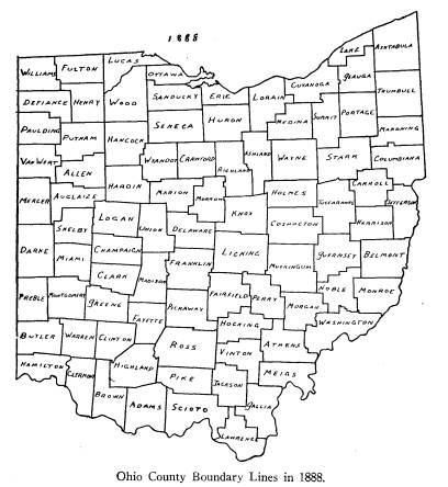
|
east corner of T 12, R 16; west with township line 3 miles to county line between Athens and Hocking; south 12 miles with county line to place of beginning. O. L. L., XLIII, p. 410. Passed March 12, 1845. |
Evolution of Ohio County
Boundaries 433
NEW COUNTIES
Ashland -- February 24, 1846.
All of Richland, Wayne, Huron and
Lorain, begin-
ning on the southern line of Lake
Township, in Wayne,
at a point 1 mile west of southeast
corner of said town-
ship, where section line meets the
south line of said
township; north along said section line
in said township
through Townships of Mohican, Perry and
Jackson, in
Wayne, to north line of said county;
west on north line
of Wayne to point where east line of Sullivan
Township,
in Lorain, intersects said north line
of Wayne; north on
east line of Sullivan Township to
northeast corner of
said township; west along north line of
Townships of
Sullivan and Troy, in Lorain, and
continuously along
north line of Ruggles Township, in
Huron, to northwest
corner of said township; south along
west line of Rug-
gles Township to point where said west
line meets north
line of Richland County; east on north
line of Richland
to east line of Section 5 in Clear
Creek Township in said
county; south along said sectional line
through Clear
Creek and Milton Townships, to point
where it intersects
the Blackfork stream of the Mohican;
along center of
said stream to west line of Section 11
in Mifflin Town-
ship; south along sectional line
through Mifflin Town-
ship and into Monroe Township to the
southwest corner
of Section 14 in said township; east 2
miles to western
line of Green Township; along western
line of Green and
Hanover Townships to southern boundary
of Richland;
east along southern line of Hanover
Township to south-
east corner of said county; north along
eastern line of
Hanover and Green Townships to the
southwest corner
Vol. XXXVI--28.
434
Ohio Arch. and Hist. Society Publications
of Lake Township, in Wayne; east along
southern line
of said township to place of beginning.
O. L. L., XLIV,
pp. 172-173. Passed February 24,
1846.
Mahoning -- March
1, 1846.
All of Trumbull and Columbiana,
beginning at
northeast corner of Coitsville Township
in first range
of townships in Western Reserve; west
along south
lines of Townships of Hubbard, Liberty,
Weathersfield,
Lordstown and Newton, in Trumbull
County, to bound-
ary line between Portage and Trumbull;
south along
boundary line to southeast corner of
Deerfield, in Por-
tage; west along south line of
Deerfield Township to
boundary line between Stark and
Columbiana; south
along line to southeast corner of
Lexington Township,
in Stark; east along north lines of
Knox and Butler
Townships, in Columbiana, to west line
of Perry in said
county; north on west line to northwest
corner of said
township; east along north line to northeast
corner of
said township; south along east line to
north line of
Salem Township, in Columbiana; east
along north line
of Townships of Salem, Fairfield and
Unity, in said
county, to boundary line between States
of Ohio and
Pennsylvania; north along said line to
place of begin-
ning. O. L. L., XLIV, p. 116.
Passed February 16,
1846.
Auglaize -- February 14, 1848.
All of Allen and Mercer, beginning at
northeast cor-
ner of Shelby County; west on north
line of Shelby to
southwest corner of Section 30, T 6,
south, of R 5, east;
south on township line to southeast
corner of Section
36, in T 7, south, of R 4, east; west
on township line to
Evolution of Ohio County
Boundaries 435
southeast corner of Section 31 in said
township; south
on section line to Darke line; westerly
on line to south-
west corner of Section 7, in T 8,
south, of R 4, east;
north on township line to northwest
corner of Section
19, in T 4, south, of R 4, east; east
on section line to
northeast corner of Section 24, in T 4,
south, of R 5,
east; south on township line to
northeast corner of Sec-
tion 36 in said township; east on
section line to northeast
corner of Section 36, T 4, south, of R
6, east; south to
southeast corner of said section; east
on township line
to northeast corner of Section 1, in T
5, south, R 8,
east; south on Hardin County line to
north line of Lo-
gan; west on line to northwest corner
of Logan; south
to place of beginning. O. L. L., XLVI,
p. 128. Passed
February 14, 1848.
It should be noticed that the line of
Auglaize, west-
erly from the Darke line to the
southwest corner of
Section 7, T 8, south, of R 4, east,
leaves in Mercer a
little wedge of land, fractional
township 12, R 4, of the
Miami River Survey. This and other
fractional town-
ships, south of the Indian Line, were
transferred to
Mercer from Darke by act of the same date
as above.
Morrow -- March 1, 1848.
All of Marion, Delaware, Knox and
Richland, be-
ginning at southwest corner of Tully
Township, in
Marion; east on township line to
southeast corner of
township; north on township line to
northeast corner of
said township; north 1 mile; east on
nearest line of lots
to northeast corner of Section 9, in
Troy Township,
Richland County; south on nearest line
of lots with east-
ern boundary lines of Franklin, Chester
and Bloomfield
Townships, Knox County, to southeast
corner of Bloom-
436
Ohio Arch. and Hist. Society Publications
field Township; west with south line of
Bloomfield
Township, Knox County, and Bennington
and Peru
Townships, Delaware County, to the
southwest corner
of Peru; north 4 miles; west along
nearest line of lots to
the west line of Oxford Township,
Delaware County;
north along township line to the
Greenville Treaty Line;
easterly to the southwest corner of
Morven Township,
Marion County; north along the west line
of Morven
and Canaan Townships, Marion County, to
the place of
beginning. Acts of Ohio, XLIV,
p. 233. Passed Feb-
ruary 24, 1848.
It should be noticed that the eastern
boundary of
Morrow does not seem to make allowance
for the jog
in the northwest corner of Knox. This
jog is made up
of Sections 4 and 9, of T 18, R 19.
These two sections
are part of Middlebury Township.
No direct reference to this jog is made
in the law,
which makes the east boundary of Morrow
a line south
from the northeast corner Section 9, T
20, R 19, on
nearest line of lots with the eastern
boundary lines of
Franklin, Chester and Bloomfield
Townships. Mr.
W. H. Van Horn, Surveyor of Knox
County, informs
me that this line, as far as he can
determine, left Sec-
tions 4 and 9, T 18, R 19, in Knox,
thus making the
northwest corner of Knox, of 1848, the
same as it is to-
day.
Vinton -- March 23, 1850.
All of Gallia, Athens, Hocking, Ross
and Jackson,
beginning at southeast corner of T 8, R
16, in Gallia;
north to southwest corner of T 10, R
15, in Athens; east
2 miles to southeast corner of Section
25 in said town-
ship; north to northeast corner of
Section 30 in said
Evolution of Ohio County
Boundaries 437
township; west to southeast corner of T
11, R 16, in
Hocking; north to northeast corner of
said township;
west to northwest corner of T 12, R 17;
south to north-
east corner T 10, R 18; west to
northwest corner of said
township; south to northeast corner of
Section 12, in
T 10, R 19, in Ross; west to northwest
corner of Section
7 in said township; south to southwest
corner of T 9, R
19, in Jackson; east to southeast
corner of said township;
south to southwest corner of Section 6,
in T 8, R 18;
east to southeast corner of Section 1
in said township;
south to southwest corner of Section
30, T 10, R 17;
east to southeast corner of Section 25
in said town-
ship; south to southwest corner of T 8,
R 16, in Gallia;
east to place of beginning. O. L.
L., XLVIII, p. 684.
Passed March 23, 1850.
For variation in section numbering, see
Peters, Ohio
Lands, pp. 56-61.
Fulton -- April 1, 1850.
All of Lucas, Henry and Williams,
beginning on
state line between Ohio and Michigan at
northeast cor-
ner of T 9, south, of R 4, east of
Michigan meridian;
south on township line to southeast
corner of T 10,
south, of R 4, east, on Fulton Line;
west on said Fulton
Line to northeast corner of T 8, north,
of R 8, east;
south to southeast corner of Section
12, in T 6, north, of
R 8, east; west on section lines to
southwest corner of
Section 7, in T 6, R 5, east, on county
line between coun-
ties of Henry and Williams; north on
said line to south-
east corner of T 7, north, of R 4,
east; west on said
township line to southwest corner of
Section 35, in T 7,
north, of R 4, east; north on section
lines to Fulton
Line; west on said line to southwest
corner of Section
438
Ohio Arch. and Hist. Society Publications
11, in T 10, south, of R 1, west of
Michigan meridian;
north on section lines to said state
line; easterly with
state line to place of beginning. O.
L. L., XLVIII, p.
682. Passed February 28, 1850.
For explanation of Michigan Survey, see
Sherman,
Ohio Land Subdivisions, pp. 153-154.
Noble -- April 1, 1851.
All of Washington, Morgan, Guernsey and
Monroe,
beginning at southwest corner of T 5, R
9, in Morgan;
north to northwest corner of said T 5;
west to south-
west corner of Section 34, in T 7, R
10; north on section
lines to north line of said T 7; west
to northwest corner
of said T 7; north to southwest corner
of Guernsey; east
to southwest corner of T 8, R 9, in
said county; north to
northwest corner of Section 18, in T 8;
east on section
lines to east line of T 8; north to
northeast corner of T 8;
east to southwest corner of Section 22,
in T 1, R 1, of
United States Military Lands; north to
northwest cor-
ner of Section 19, in T 1; east on
section lines to east line
of T 1; north to northwest corner T 8,
R 7, in Guernsey;
east to west line of Belmont; south to
southwest corner
of Belmont; west to southwest corner of
Section 19, in
T 8, R 7; south on section lines to
northwest corner of
Section 19, in T 6, R 7, in Monroe;
east to northeast cor-
ner of Section 13, in T 6; south on
section lines to south-
east corner of Section 18, T 4, R 7, in
Washington; west
to east line of T 5, R 8, in said
county; north to northeast
corner of Section 25, in T 5; west to
southwest corner of
Section 23; north to northwest corner
of Section 23;
west to southwest corner of Section 15;
north to south-
west corner of Section 10; west to
southwest corner of
Section 8; north to northwest corner of
Section 8; west
Evolution of Ohio County
Boundaries 439
to west line of T 5, in R 8; south to
southeast corner of
Morgan; west to place of beginning. O. L.
L., XLIX,
pp. 979-980. Passed March 11, 1851.
For variation in section numbering, see
Peters, Ohio
Lands, pp. 56-61
CHANGES
Morgan from Washington -- February 14, 1846.
By this act Sections 1, 2, 3 and 4 of
Township 8,
Range 12, were detached from Washington
and added
to Morgan. O. L. L., XLIV,
p. 105. It should be noted
that Section 11 of this township is
still legally part of
Washington, since it was not included
in the act of
March 11, 1845, transferring that part
of the township
in Athens to Morgan, as well as
Sections 5, 6 and 12,
in Washington, to Morgan. This is also
referred to in
W. E. Peters' article reprinted in
pamphlet form, from
the Athens Sunday Messenger, December
21, 1924, en-
titled, "Tells Strange Story of
Ohio's 'Lost Lands'."
I have not shown this on any map except
that of 1845.
Richland from Ashland -- February 5, 1847.
Sections 1, 2, 11, 12, 13 and 14, which
were, pre-
vious to erection of Ashland, a part of
Monroe Town-
ship, in Richland County, and at this
time part of Green
Township, Ashland County, are attached
to Monroe
Township in Richland. Also parts of
following sections
to-wit -- southwest one-fourth of
Section 3 and south-
east one-fourth and northwest
one-fourth of Section 4,
all of T 23, and R 17, are detached
from Ashland and
attached to Richland. O. L. L., XLV,
p. 37. Passed
February 5, 1847.
440
Ohio. Arch and Hist. Society Publications
Tuscarawas from Stark -- February 4, 1848.
Portion of boundary line altered to run
as follows --
beginning at point where south line of
Section 25, in T
9, R 9, in Stark, intersects the
Tuscarawas River, and
thence northwardly and westwardly along
center of
river until it again intersects the
present boundary line
between Stark and Tuscarawas Counties
at or near the
aqueduct north of town of Bolivar. All
of Stark south
of the above line is attached to
Lawrence Township,
Tuscarawas County. O. L. L., XLVI,
p. 79. Passed
February 4, 1848.
Allen from Putnam, Van Wert and
Mercer -- February
14, 1848.
Township 2, south, of R 7, and 8, east;
the south
half of T 2, south, of R 5 and 6, east,
and Sections 31,
32, 33, 34, 35 and 36, in T 1, south,
of R 8, east, in Put-
nam; the east half of T 3, south, of R
4, east, in Van
Wert, and the northeast quarter of T 4,
south, of R 4,
east, in Mercer, are attached to Allen
County. O. L.
L., XLVI, p. 129. Passed February 14, 1848.
Putnam from Van Wert -- February 14, 1848.
East half of T 1, south, of R 4, east,
in Van Wert, at-
tached to Putnam. O. L. L., XLVI,
p. 129. Passed
February 14, 1848.
Van Wert from Mercer -- February 14, 1848.
The northwest quarter of T 4, south, of
R 4, east, in
Mercer, attached to Van Wert. O. L.
L., XLVI, p. 129.
Passed February 14, 1848.
Evolution of Ohio County
Boundaries 441
Mercer from Darke -- February 14, 1848.
Fractional T 15, R 1 and 2, east, and
fractional T 12
and 13, of R 3 and 4, east, in Darke,
are attached to
Mercer. O. L. L., XLVI,
p. 129. Passed February 14,
1848.
It will be noticed that strictly
according to our ex-
planation the little wedge in the
northwest part of
Darke, between the state line and the
Greenville Treaty
Line, should belong to Mercer, because
Darke was
made to extend only up to the
Greenville Treaty Line,
and hence, even before the above
change, belonged to
Mercer County.
However, Mr. German Warner, Engineer of
Darke
County, explains why this wedge belongs
to Darke in
this way: "The Government Survey
by D. C. Cooper, as
made in 1800, shows that the wedge
between the State
Line and Greenville Treaty Line was
made a part of
Sections 6 and 7, T 14, R 1, (of Miami
River Survey),
and as far as I know, this land has
been a part of Darke
County ever since the organization of
the county." It
should be noticed, however, that Mr. C.
E. Sherman, in
his large map accompanying his Original
Ohio Land
Subdivisions, does not include this as part of Sections
6 and 7, T 14, R 1, of the Miami River
Survey, but rather
as part of the survey south and east of
the First Prin-
cipal Meridian.
By what authority the Government Survey
by D. C.
Cooper, in 1800, caused this wedge to
be included in the
Miami River Survey, I do not know. I
believe there
was no authority, and I see no reason
to doubt that,
technically, it is part of Mercer
County, yet practically,
of course, Mr. Warner is quite right
that, since it al-
442
Ohio Arch. and Hist. Society Publications
ways has been part of Darke, it always
should remain
so. This is but one of the numerous
cases in the evolu-
tion of Ohio county boundaries where
the fact is su-
perior to the law.
Marion from Delaware -- March 1, 1848.
Attach to Marion so much of Delaware as
is con-
tained in the following -- beginning on
Greenville
Treaty Line at northeast corner of
Marlborough Town-
ship, Delaware County; south along line
between Marl-
borough and Westfield Townships to the
southwest cor-
ner of said Westfield Township; west
along the original
township line, and with said line
continued west, to the
west line of Delaware; north along the
county line to
the Greenville Treaty Line; easterly
with said line to
place of beginning. O. L. L., XLVI,
p. 233. Passed
February 24, 1848.
Richland from Morrow -- March 22, 1849.
Sections 28 and 33 which were, previous
to the
erection of Morrow, a part of Troy
Township, in Rich-
land, and at this time a part of Troy
Township, Morrow
County, are hereby detached from Morrow
and at-
tached to Troy Township, in Richland
County. O. L.
L., XLVII, p. 362. Passed March 22, 1849.
Lucas from Ottawa -- April 1, 1850.
For purpose of restoring to Lucas its
constitutional
amount of territory the eastern limits
of said county be
extended, beginning on Fulton Line at
the southeast
corner of T 10, south, of R 9, east;
east on said line to
Lake Erie; most direct line in
northeast direction to line
between American and British
Governments in Lake
Evolution of Ohio County
Boundaries 443
Erie; westerly on said line to dividing
line between
States of Ohio and Michigan; on said
line to northerly
cape of the Maumee Bay. O. L. L., XLVIII,
p. 682.
Passed February 28, 1850.
It will be seen that there is some
difficulty in adapt-
ing this statute to actualities. The
west line of Ottawa
as it was extended north to the
Michigan line, (See O.
L. L., XXXVIII, p. 99), was the line between R 12 and
13, of the Survey north and east of the
First Principal
Meridian, as designated in the act
forming Sandusky,
(O. L. L., XVIII, p. 90.) This extension of Lucas is
made to begin at the southeast corner
of T 10, south, R
9, east, of Michigan Survey. This
point, from the map,
is obviously too far east to begin on
the old Ottawa line.
It has been suggested that, by a
typographical error, the
southeast corner was designated when
the southwest
corner was the point meant. However,
even this is too
far east, as the following quotation
from the letter of
J. A. Snell, of the Surveyor's office
in Lucas County,
shows: "Even if this statute
called for a point of begin-
ning at the southwest corner of
Township 10, south,
Range 9, east, it would take in all of
the land in Lucas
County east of a northern extension of
the west bound-
ary of Ottawa County, according to our
records . . .
Our copy of the original Government
Survey shows that
the line between Ranges 12, east, and
13, east, in the
Township south of the Fulton County
line, is 26.76
chains west of the line between Ranges
8, east, and 9,
east, of the Michigan Survey. In other
words, the
southwest corner of Township 10, south,
Range 9, east,
is 26.76 chains east of what we show as
the line between
Ottawa and Wood Counties."
444
Ohio Arch. and Hist. Society Publications
Hocking from Athens and Fairfield -- March 23, 1850.
To restore to Hocking its
constitutional amount of
territory -- Township of Ward, in
Athens, attached to
Hocking. North line of said township to
be part of di-
viding line between Hocking and Perry,
and the east
and south line of said township to be a
part of dividing
line between Athens and Hocking; and so
much of Au-
burn Township as lies south of original
survey line
thereof, and the whole township of
Perry, in Fairfield,
attached to Hocking; east line of
Auburn Township be
part of dividing line between Perry and
Hocking; and
north and west lines of Auburn Township
be part of
dividing line between Fairfield and
Hocking; and north
line of Perry Township be a part of
dividing line be-
tween Fairfield and Hocking; and west
line of said
township be dividing line between
Pickaway and Hock-
ing. O. L. L., XLVIII, p. 684.
Passed March 23,
1850.
Jackson from Gallia -- March 23, 1850.
Two tiers of sections containing 12
square miles on
east side of T 7, R 17, and one tier of
sections contain-
ing 6 square miles on north side of T
6, R 17, in Gallia,
attached to Jackson. O. L.
L., XLVIII, p. 685. Passed
XLIX, p. 150. Passed March 25, 1851.
Franklin from Fairfield -- March 25, 1851.
Western tier of sections of T 15, R 20,
(Violet
Township), Fairfield County, attached
to Truro and
Madison Townships, Franklin County. O. L.
L.,
XLIX, p. 150. Passed March 25, 1851.
Evolution of Ohio County
Boundarics 445
Morgan from Washington -- April 1, 1851.
So much of Roxbury Township, in
Washington, as
lies north of the following
line--beginning at northwest
corner of Section 33, in T 8, R 12;
east 2 miles to north-
east corner of Section 27; south to
southwest corner of
lot number 1097; east to southeast
corner of lot number
1092; south to north line of fractional
Section 15; east
to east line of said township--attached
to Morgan
County--last described lines with following:
Beginning
at northeast corner fraction Section 3,
in said township;
north to northeast corner of said
township; west to
Muskingum River, constitute part of
boundary between
Washington and Morgan Counties. O.
L. L., XLIX,
p. 437. Passed March 11, 1851.
This change was part of the law
establishing Noble
County.
An error has been committed in the
making of this
law because the northern corner of
Section 33, T 8, R
12, at which the Washington boundary
must begin, is
six miles west of the present point
where it actually does
begin. It should be, of course, Section
33, T 8, R 11. We
have seen that all of T 8, R 12, except
Section 11, was
annexed to Morgan by acts of March 11,
1845, and Feb-
ruary 14, 1846.
Monroe from Washington -- April 1, 1851.
All of the Townships of Liberty, Ludlow
and Jolly,
in Washington, that lie east and north
of following line
--beginning at northwest corner of
Section 6, T 4, R 7,
in Washington; south to southwest
corner of Section 5,
T 4; east on section lines to southeast
corner of frac-
tional Section 5, T 2, R 5, in said
county, attached to
446
Ohio Arch. and Hist. Society Publications
Monroe, and said described line
constitutes part of
boundary line between Washington and
Monroe. O. L.
L., XLIX, p. 980. Passed March 11, 1851.
This change also accompanied the act
establishing
Noble County.
Clermont from Warren -- April 2, 1859.
Annexed to Clermont County, to form
part of Town-
ship of Wayne, that portion of Warren
which lies
within limits of Epple's Survey, number
764, to-wit: Be-
ginning at corner of Warren and Clinton
in the line of
Clermont; thence with a line of Warren
and Clinton to
where it intersects said survey line;
with said survey
line to northeast corner of survey;
westerly with said
survey line to where it intersects
Clermont and Warren
County line. O. L. L., LVI, p.
296.
This act to be submitted to the
electors of the above
counties at an election to be held on
the second Tuesday
of October, 1859. If a majority of all
electors voting,
are in favor, the act shall take effect
from November 1.
Mr. P. O. Montfort, Surveyor of Warren
County,
and Mr. Frank H. Galbreath, Surveyor of
Clermont
County, both inform me that this
proposed annexation
to Clermont is recorded in none of the
county docu-
ments. It is, therefore, to be inferred
that the referen-
dum failed.
Highland-Brown Line Resurveyed --
October 19-27,
1874.
This re-survey resulted in the addition
to Highland,
from Brown, of an inverted wedge of
territory extend-
ing along the west boundary of
Highland.
The reason why the change of 1874 was
made neces-
Evolution of Ohio County
Boundaries 447
sary is shown by the following
quotation from a letter
of C. Luther Swaim, Prosecuting
Attorney of Clinton
County: "The early surveyors (in
this district) did not
make enough allowance for the variation
of the mag-
netic needle. In this county, on all of
the early lines,
there is a constant error of 5. This
shows on the maps
from the way the county is tilted to
the east." This slant
is shown in the lines of many other
counties as well.
Mr. Ray P. Murphy, of Highland County,
has fur-
nished me with the report of the County
Surveyor of
Highland, of above date, from the
Surveyor's Record
No. 3, page 26, which gives the data
for the re-survey of
the complete line between Highland and
Brown. It was
re-surveyed in pursuance of an
agreement between the
Commissioners of the Counties of
Highland and Brown
on the authority of the general act of
April 9, 1852, con-
cerning re-surveys. O. G. L., 50, p. 134.
In this report the point of the
southwest corner of
Highland County was taken as a basis.
The east-west
Brown-Highland line was drawn from it
due east and
west on October 19. On October 27, the
north-south
Brown-Highland line was drawn No. 0 41'
W. Thus
the "5" error is corrected.
This swings the west line of
Highland around to an almost due north
position.
Mr. Swaim, of Clinton County, says,
"I regard such
a change as very unusual, as we have
always kept the
constant error in the re-surveys of the
county lines. Our
lines have been moved one way or the
other in the mid-
dle, where it was found that a true
line was not run, but
the corners have never been changed, as
far as I can find
out."
Mr. Swaim further informs me that the
early maps
448
Ohio Arch. and Hist. Society Publications
that he has seen, dating as late as
1882, show this
Brown-Highland line with the
"5" error. He says,
"An old map, drawn in 1859, by the
County Surveyor,
gives Brown County as running to the
western edge of
the Bootleg. This is also true of a map
of 1844, in an
old geography that I have. It is also
true of a county
map published in the county history of
1882, map not
dated. Maps in 1890 show the
change."
Logan-Shelby Line Changed -- April 11, 1883.
Line between Logan and Shelby changed
to run par-
allel with section lines instead of
angling across them-
to-wit: said line be located on north
and south center
line of Section 36, T 6, south, R 7,
east, and Sections 1,
12, 13, 24, 25 and 36, of T 7, south, R
7, east, to Green-
ville Treaty Line; with it west to
center of east half of
Section 29, T 2, R 8, east; with line
through center of
east half of Sections 29 and 32, R 8,
east, and of Sec-
tions 5, 8, 17 and 20, to Great Miami
River. Proposi-
tion to change county line submitted to
qualified electors
of said county at annual election held
on second Tuesday
of October, 1883. Majority required for
change. 0.
L. L., LXXX, p. 324. Passed April 11, 1883.
This revision was made necessary by the
fact that
the line in question crossed three
separate surveys, the
lines of which were not parallel -- the
Survey south
and east of the First Principal
Meridian; the Miami
River Survey; and the Survey between
the Miami
Rivers. See Peters' map. They are shown
in Sher-
man's large map accompanying his
report.
The following excerpt of a letter from
L. H. Har-
man, Deputy Auditor of Shelby County,
reveals the suc-
cess of the change which was submitted
to the people:
Evolution of Ohio County
Boundaries 449
"An investigation of the
newspapers of that time dis-
closes that the election regarding this
change was held
the second Tuesday of October, 1883,
and was accepted
by the people by a vote of 4407 yes,
and 658 no."
Auglaize-Logan Line Changed -- March 15, 1888.
Boundary line between Auglaize and
Logan changed
to run parallel with section lines
instead of angling
across them--to-wit: Commencing at the
northeast cor-
ner of Shelby, being the quarter corner
to Sections 25
and 36, T 6, south, R 7, east, and
running east to the
southeast corner of Section 25, T 6,
south, R 7, east; east
along quarter-section line through
Sections 7, 8, 9, 10
and fractional 11, T 6, south, R 8,
east, to west line of
Valentine Peers, Virginia Military
Survey, No. 12,276,
original quantity 2666 2/3 acres;
parallel to south line
of said survey to Hardin line; south
along said line to
southwest corner of said Hardin County.
Proposition
to change county line submitted to qualified
electors of
said county at annual election, first
Tuesday of Novem-
ber, 1888. Majority required for
change. 0. L. L.,
LXXXV, p. 418. Passed March 15, 1888.
See explanation on Logan-Shelby line.
George A. Shuster, Surveyor of Auglaize
County,
has furnished an official map of the
county, in which he
has taken great care to show accurately
the change made
by drawing the boundary, previous to
1888, over the one
subsequently formed. My own map is
based on Mr.
Shuster's careful work.
I. P. Core, Surveyor of Logan County,
has given me
further official information from the
records in his of-
fice. He writes, "I find Logan and
Shelby County Line
Survey recorded December 19, 1884, and
Auglaize and
Vol. XXXVI--29.
450
Ohio Arch. and Hist. Society Publications
Logan County Line Survey recorded in
this office June
18, 1889, and May 1, 1890."
NOTE
It will be noticed by a reference to
Sherman's large
map that there is a slight jog in Clark
County in Section
32, Township 5, of Range 8, of the
Survey between the
Miamis, suggesting that the boundary
might have been
changed since the act of February 25,
1819. This is a
draftsman's mistake, as the following
quotation from
Deputy County Surveyor, Edwin R. Burke,
of Clark
County, shows: "After a thorough
investigation I am
convinced that there has been no change
in this
boundary since the enactment of the
statute of January
25, 1818, which is the one to which you
refer. . . .
I am of the opinion that in the
preparation of this map
(Sherman's) the draftsman was misled by
the boundary
of the Village of Clifton. This village
is partly in
Greene County and partly in Clark
County. Some maps
show the eastern and northern
boundaries of the village
in such manner that this error is
easily made. . . .
I found one map that was so pronounced
in this respect
that, had I not known differently, I
would have been
certain that the entire Village of
Clifton is situated in
Greene County."
ALPHABETICAL SUMMARY OF COUNTY
BOUNDARY CHANGES
This includes the evolution of each
county, and all
the changes affecting it, from the date
of its formation
until it assumed its final form.
Evolution of Ohio County
Boundaries 451
Adams County
July 10, 1797 -- Erected
and organized.
August 20, 1798 -- Diminished
by formation of
Ross.
September 1, 1798 -- Part of Hamilton
attached.
May 1, 1803 -- Diminished by formation
of Scioto.
May 1, 1805 -- Diminished by formation
of High-
land.
February 1, 1815 -- Diminished
by formation of
Pike.
March 1, 1817 -- Diminished by
formation of
Brown.
Allen County
March 1, 1820 -- Erected
and attached to Shelby.
March 1, 1828 -- Attached to Mercer.
March 1, 1831 -- Organized.
February 14, 1848 -- Diminished by
formation of
Auglaize. Parts of Putnam, Van Wert,
and
Mercer attached.
Ashland County
February 24, 1846 -- Erected
and organized.
February 5, 1847 -- Part
attached to Richland.
Ashtabula County
June 7, 1808 -- Erected and attached to
Trumbull
and Geauga.
February 20, 1809 -- Part attached to
Trumbull.
May 1, 1811 -- Organized and part of
Trumbull
attached.
January 29, 1827 -- Islands in Lake
Erie attached.
452
Ohio Arch. and Hist. Society Publications
Athens County
March 1, 1805 -- Erected and organized.
January 30, 1807 -- Boundary
with Gallia altered.
February 18, 1807 -- Boundary with Washington
altered.
February 10, 1814 -- Boundary with Washington
altered.
March 1, 1816 -- Diminished by
formation of Jack-
son.
March 1, 1818 -- Diminished by
formation of
Hocking.
April 1, 1819 -- Diminished by
formation of
Meigs.
March 11, 1845 -- Part attached to
Morgan.
March 12, 1845 -- Part attached to
Hocking.
March 23, 1850 -- Diminished by
formation of
Vinton. Part attached to Hocking.
Auglaize County
February 14, 1848 -- Erected
and organized.
March 15, 1888 -- Boundary
with Logan altered.
Belmont County
September 7, 1801 - Erected and
organized.
March 1, 1810 -- Diminished by
formation of
Guernsey.
March 1, 1813 -- Part of Monroe
attached tempor-
arily until organized.
March 1, 1815 -- Diminished by organization
of
Monroe.
Brown County
March 1, 1818 -- Erected and organized.
Evolution of Ohio County
Boundaries 453
October, 1874 -- Highland-Brown
line changed by
re-survey. Part attached to Highland.
Butler County
May 1, 1803 -- Erected and organized.
January 20, 1808 -- Part of Hamilton
attached.
March 1, 1808 -- Diminished by
formation of
Preble.
March 1, 1815 -- Part attached to
Warren.
Carroll County
January 1, 1833 -- Erected
and organized.
February 3, 1834 -- North boundary
altered.
Champaign County
March 1, 1805 -- Erected and organized.
March 1, 1818 -- Diminished by
formation of
Logan and Clark. Part attached to
Madison.
April 1, 1820 -- Cessation of any
jurisdiction north
of Indian Boundary Line by formation of
coun-
ties therein.
Clark County
March 1, 1818 -- Erected and organized.
February 25, 1819 -- Boundary with
Greene al-
tered.
January 22, 1827 -- Boundary
with Madison al-
tered.
Clermont County
December 6, 1800 -- Erected and
organized.
March 1, 1805 -- Diminished by
formation of
Highland.
454
Ohio Arch. and Hist. Society Publications
March 1, 1818 -- Diminished by
formation of
Brown.
Clinton County
March 1, 1810 -- Erected and organized.
February 4, 1813 -- Part of Highland
attached.
March 1, 1815 -- Part of Highland
attached. Part
of Warren attached.
Columbiana County
May 1, 1803 -- Erected and organized.
February 13, 1808 -- Wayne and Stark
attached
temporarily until organization of
Stark.
January 1, 1809 -- Diminished
by organization of
Stark, to which was attached Wayne.
January 1, 1833 -- Diminished by
formation of
Carroll. Part attached to Jefferson.
March 1, 1846 -- Diminished by
formation of Ma-
honing.
Coshocton County
January 31, 1810 -- Erected and
attached to Mus-
kingum and Tuscarawas.
April 1, 1811 -- Organized.
January 20, 1824 -- Part of Holmes
attached tem-
porarily until organization of Holmes.
January 4, 1825 -- Diminished by
organization of
Holmes.
Crawford County
April 1, 1820 -- Erected and attached
to Delaware.
February 17, 1824 -- Part attached to
Seneca until
organization.
Evolution of Ohio County
Boundaries 455
April 1, 1824 -- Part attached to
Marion until or-
ganization.
April 1, 1826 -- Organized.
February 3, 1845 -- Diminished
by formation of
Wyandot. Part of Richland and Marion
at-
tached.
March 1, 1848 -- Diminished by
formation of
Morrow.
Cuyahoga County
June 7, 1808 -- Erected and attached to
Geauga.
May 1, 1810 -- Organized. Huron and
parts of
Geauga attached temporarily until
organization
of Huron.
January 22, 1811 -- Boundary
established between
Huron and Cuyahoga.
February 18, 1812 -- Boundary between
Huron
and Cuyahoga altered.
April 1, 1815 -- Diminished by
organization of
Huron.
December 26, 1822 -- Part of Lorain
attached tem-
porarily until organization of Lorain.
April 1, 1824 -- Diminished by
organization of Lo-
rain.
January 29, 1827 -- Islands in Lake Erie attached.
Part of Lorain attached.
March 6, 1840 -- Part
of Lake attached tempora-
rily until organization of Lake.
March 20, 1840 -- Diminished by organization of
Lake.
January 29, 1841 -- Part attached to
Geauga and
part of Geauga attached.
January 11, 1843 -- Part of Geauga
attached.
456
Ohio Arch. and Hist. Society Publications
Darke County
January 3, 1809 -- Erected and attached
to Miami.
January 7, 1812 -- Part of Montgomery
attached.
March 1, 1817 -- Organized.
April 1, 1820 -- Mercer and Van Wert
attached
until organization of Mercer.
January 2, 1824 -- Diminished
by organization of
Mercer, detaching Van Wert.
February 14, 1848 -- Part
attached to Mercer.
Defiance County
April 7, 1845 -- Erected and organized.
Delaware County
April 1, 1808 -- Erected and organized.
February 17, 1809 -- Part of Franklin
attached.
April 1, 1820 -- Diminished by
formation of Union
and counties in Indian Lands.
February 24, 1848 -- Diminished
by formation of
Morrow. Part attached to Marion.
Erie County
March 15, 1838 -- Erected.
March 16, 1838 -- Organized.
March 6, 1840 -- Diminished
by formation of Ot-
tawa. Part of Huron attached.
March 8, 1845 -- Kelly's Island
attached.
Fairfield County
December 9, 1800 -- Erected and
organized.
March 1, 1804 -- Diminished by
formation of
Muskingum.
March 1, 1808 -- Diminished by
formation of
Licking and Knox, and enlargement of
Frank-
lin.
Evolution of Ohio County
Boundaries 457
March 1, 1810 -- Diminished by
formation of
Pickaway.
March 1, 1818 -- Diminished by
formation of
Perry and Hocking.
March 23, 1850 -- Part attached to
Hocking.
March 25, 1851 -- Part attached to
Franklin.
Fayette County
March 1, 1810 -- Erected
and organized.
Franklin County
April 30, 1803 -- Erected and
organized.
March 1, 1805 -- Diminished by
formation of
Champaign.
March 1, 1808 -- Part of Fairfield
attached.
April 1, 1808 -- Diminished by
formation of Dela-
ware.
February 17, 1809 -- Part attached to
Delaware.
March 1, 1810 -- Diminished by
formation of
Pickaway and Madison.
January 27, 1817 -- Part of Licking
attached.
April 1, 1820 -- Diminished by
formation of
Union. Part attached to Madison.
March 4, 1845 -- Franklin-Madison line
altered.
March 25, 1851 -- Part of Fairfield
attached.
Fulton County
April 1, 1850 -- Erected and organized.
Gallia County
April 30, 1803 -- Erected and
organized.
December 29, 1804 -- Part attached to
Scioto.
January 30, 1807 -- Boundary with
Athens al-
tered.
458
Ohio Arch. and Hist. Society Publications
December 21, 1815 -- Part of Lawrence
attached
temporarily until organization of
Lawrence
March 1, 1816 -- Diminished by
formation of Jack-
son.
March 1, 1817 -- Diminished by
organization of
Lawrence.
December 22, 1818 -- Part attached to
Lawrence.
April 1, 1819 -- Diminished by
formation of
Meigs.
April 1, 1839 -- Part
of Lawrence attached.
February 11, 1840 -- Part of Lawrence
attached
and part attached to Lawrence.
March 23, 1850 -- Diminished by formation
of
Vinton. Part attached to Jackson.
Geauga County
March 1, 1806 -- Erected and organized.
June 7, 1808 -- Part of Ashtabula
attached tempo-
rarily until organization of Ashtabula.
Cuya-
hoga attached temporarily until
organization of
Cuyahoga.
February 7, 1809 -- Part of Huron
attached tem-
porarily until organization of Huron.
May 1, 1810 -- Diminished by
organization of Cuy-
ahoga. Part of Huron attached to
Cuyahoga
temporarily until organization of
Huron. Part
of Geauga attached to Cuyahoga temporarily
until organization of Huron.
May 1, 1811 -- Diminished by
organization of
Ashtabula.
January 29, 1827 -- Islands in
Lake Erie attached.
March 6, 1840 -- Part of Lake attached
tempo-
rarily until organization of Lake.
Evolution of Ohio County
Boundaries 459
March 20, 1840 -- Diminished
by organization of
Lake.
January 29, 1841 -- Part attached to
Cuyahoga
and part of Cuyahoga attached.
January 11, 1843 -- Part attached to
Cuyahoga.
Greene County
May 1, 1803 -- Erected and organized.
March 1, 1805 -- Diminished by
formation of
Champaign.
March 1, 1818 -- Diminished by
formation of
Clark.
February 25, 1819 -- Greene-Clark
boundary al-
tered.
Guernsey County
March 1, 1810 -- Erected and organized.
March 1, 1813 -- Part
of Monroe attached tem-
porarily until organization of Monroe.
March 1, 1815 -- Diminished by
organization of
Monroe.
December 29, 1817 -- Part of Morgan
attached
temporarily until organization of
Morgan.
March 1, 1819 -- Diminished by
organization of
Morgan.
April 1, 1851 -- Diminished by
formation of Noble.
Hamilton County
January 2, 1790 -- Erected and
organized.
February 11, 1792 -- Boundary extended.
August 15, 1796 -- Diminished by formation of
Wayne, Northwest Territory.
July 10, 1797 -- Diminished by
formation of
Adams.
460 Ohio Arch. and Hist. Society Publications
June 22, 1798 -- Part
of Knox, Northwest Terri-
tory, attached.
August 20, 1798 -- Diminished by
formation of
Ross.
September 1, 1798 -- Part attached to
Adams.
December 6, 1800 -- Diminished by formation of
Clermont.
April 30, 1802 -- Diminished
by Enabling Act of
Ohio.
May 1, 1803 -- Diminished by formation
of War-
ren, Butler, Montgomery, and Greene.
January 20, 1808 -- Part attached to
Butler.
Hancock County
April 1, 1820 -- Erected and attached
to Wood un-
til organization.
March 1, 1828 -- Organized.
February 3, 1845 -- Diminished by
formation of
Wyandot.
Hardin County
April 1, 1820 -- Erected and attached
to Logan
until organized.
March 1, 1833 -- Organized.
February 3, 1845 -- Diminished by
formation of
Wyandot.
Harrison County
February 1, 1813 -- Erected and
organized.
January 1, 1833 -- Diminished by
formation of
Carroll. Part of Tuscarawas attached.
Henry County
April 1, 1820 -- Erected and attached
to Wood.
Evolution of Ohio County
Boundaries 461
February 2, 1824 -- Attached to
Williams.
December 26, 1834 -- Organized.
June 20, 1835 -- Diminished by
formation of
Lucas.
April 7, 1845 -- Diminished by
formation of De-
fiance.
April 1, 1850 -- Diminished
by formation of Ful-
ton.
Highland County
May 1, 1805 -- Erected and organized.
March 1, 1810 -- Diminished by
formation of
Fayette and Clinton.
February 4, 1813 -- Part attached to
Clinton.
March 1, 1815 -- Part attached to
Clinton.
October, 1874 -- Brown-Highland line
re-sur-
veyed. Part of Brown attached.
Hocking County
March 1, 1818 -- Erected and organized.
March 1, 1834 -- Part attached to Ross.
March 12, 1845 -- Part of Athens
attached.
March 23, 1850 -- Diminished by formation
of
Vinton. Parts of Athens and Fairfield
attached.
Holmes County
January 20, 1824 -- Erected and
attached to Co-
shocton, Tuscarawas, and Wayne until
organiza-
tion.
January 4, 1825 -- Organized.
Huron County
February 7, 1809 -- Erected
and attached to Por-
tage and Geauga until organization.
462
Ohio Arch. and Hist. Society Publications
May 1, 1810 -- Attached to Cuyahoga
until or-
ganization.
January 22, 1811 -- Boundary
established between
Huron and Cuyahoga.
February 18, 1812 -- Boundary
established be-
tween Huron and Cuyahoga.
April 1, 1815 -- Organized and part of
Indian
Lands attached.
April 1, 1820 -- Diminished
by formation of coun-
ties in Indian Lands.
December 26, 1822 -- Part of Lorain
attached tem-
porarily until organization.
April 1, 1824 -- Diminished by
organization of
Lorain.
March 15, 1838 -- Part of Erie attached
tempo-
rarily until organization.
March 16, 1838 -- Diminished
by organization of
Erie.
February 24, 1846 -- Diminished by
formation of
Ashland.
Jackson County
March 1, 1816 -- Erected and organized.
March 1, 1818 -- Part of Ross attached.
January 11, 1839 -- Part attached to
Ross.
February 7, 1843 -- Part of Pike
attached and part
attached to Pike.
March 23, 1850 -- Diminished by
formation of
Vinton. Part of Gallia attached.
Jefferson County
July 29, 1797 -- Erected and organized.
Evolution of Ohio County
Boundaries 463
December 19, 1799 -- Part of Washington
at-
tached.
July 10, 1800 -- Diminished by
formation of Trum-
bull.
September 7, 1801 -- Diminished by
formation of
Belmont.
May 1, 1803 -- Diminished by formation
of Co-
lurnbiana.
January 31, 1807 -- Western
boundary extended.
February 11, 1809 -- Part attached to
Tuscara-
was.
February 1, 1813 -- Diminished
by formation of
Harrison.
January 1, 1833 -- Diminished by
formation of
Carroll. Part of Columbiana attached.
Knox County
March 1, 1808 -- Erected and organized.
Rich-
land attached temporarily until
organization.
March 1, 1813 -- Diminished by
organization of
Richland.
March 1, 1848 -- Diminished by
formation of
Morrow.
Lake County
March 6, 1840 -- Erected and attached
to Geauga
and Cuyahoga.
March 20, 1840 -- Organized.
Lawrence County
December 21, 1815 -- Erected and
attached to
Scioto and Gallia.
March 1, 1817 -- Organized. Part of
Scioto at-
tached.
464 Ohio Arch. and Hist. Society Publications
March 1, 1818 -- Part
attached to Scioto.
December 22, 1818 -- Part
of Gallia attached.
March 1, 1826 -- Part
attached to Scioto.
April 1, 1839 -- Part attached to
Gallia.
February 11, 1840 -- Part
of Gallia attached and
part attached to Gallia.
Licking County
March 1, 1808 -- Erected
and organized.
January 27, 1817 -- Part
attached to Franklin.
February 20, 1837 -- Part attached to
Perry.
Logan County
March 1, 1818 -- Erected and organized.
April 1, 1820 -- Diminished by
formation of
Union and other counties from Indian
Country.
Part of Indian Country attached.
April 11, 1883 -- Logan-Shelby line
altered.
March 15, 1888 -- Logan-Auglaize line
altered.
Lorain County
December 26, 1822 -- Erected and
attached to
Cuyahoga and Lorain.
April 21, 1824 Organized.
January 29, 1827 -- Part of Medina
attached.
Islands in Lake Erie attached. Part
attached to
Cuyahoga.
March 3, 1840 -- Part
attached to Medina.
February 24, 1846 -- Diminished
by formation of
Ashland.
Lucas County
June 20, 1835 -- Erected and organized.
March 14, 1836 -- Part of Wood
attached.
Evolution of Ohio County
Boundaries 465
March 6, 1840 -- Diminished by
formation of Ot-
tawa.
April 1, 1850 -- Diminished by
formation of Ful-
ton. Part of Ottawa attached.
Madison County
March 1, 1810 -- Erected and organized.
March 1, 1818 -- Diminished by
formation of
Clark. Part of Champaign attached.
April 1, 1820 -- Diminished by
formation of
Union. Part of Franklin attached.
March 4, 1845 -- Madison-Franklin line
altered.
Mahoning County
March 1, 1846 -- Erected
and organized.
Marion County
April 1, 1820 -- Erected and attached
to Delaware
until organization of Marion.
March 1, 1824 -- Organized and part of
Crawford
attached temporarily until organization
of Craw-
ford.
April 1, 1826 -- Diminished by
organization of
Crawford.
February 3, 1845 -- Diminished by
formation of
Wyandot. Part attached to Crawford.
March 1, 1848 -- Diminished by
formation of
Morrow. Part of Delaware attached.
Medina County
February 18, 1812 -- Erected and
attached to
Portage until organization.
January 14, 1818 -- Organized.
Vol. XXXVI--30.
466
Ohio Arch. and Hist. Society Publications
December 26, 1822 -- Part of Lorain
attached
temporarily until organization of
Lorain.
April 1, 1824 -- Diminished by
organization of
Lorain.
January 29, 1827 -- Part attached to
Lorain.
Portage-Medina line altered.
March 3, 1840 -- Part of Summit attached until
organization of Summit. Part of Lorain
at-
tached.
March 17, 1840 -- Diminished by
organization of
Summit.
Meigs County
April 1, 1819 -- Erected and organized.
Mercer County
April 1, 1820 -- Erected and attached
to Darke
until organization of Mercer.
January 2, 1824 -- Organized. Van Wert at-
tached until organization of Van Wert.
March 1, 1826 -- Part
of Shelby attached.
March 1, 1828 -- Allen
attached until organization
of Allen.
March 1, 1831 -- Diminished by
organization of
Allen.
March 18, 1837 -- Diminished by
organization of
Van Wert.
February 14, 1848 -- Diminished
by formation of
Auglaize. Parts attached to Allen and
Van
Wert. Part of Darke attached.
Miami County
March 1, 1807 -- Erected
and organized.
Evolution of Ohio County
Boundaries 467
January 3, 1809 -- Darke attached until
organiza-
tion.
January 7, 1812 -- Part of Montgomery
attached.
March 1, 1817 -- Diminished by
organization of
Darke.
April 1, 1819 -- Diminished by
formation of
Shelby.
April 1, 1820 -- Any rights remaining
in Indian
Lands ceased by formation of counties
therein.
Monroe County
March 1, 1813 -- Erected and attached
to Bel-
mont, Washington, and Guernsey until
organ-
ized.
March 1, 1815 -- Organized. Part of
Washington
attached.
December 24, 1819 -- Part of Morgan
attached.
April 1, 1851 -- Diminished by
formation of No-
ble. Part of Washington attached.
Montgomery County
May 1, 1803 -- Erected
and organized.
March 1, 1807 -- Diminished by
formation of
Miami.
March 1, 1808 -- Diminished by
formation of
Preble.
January 7, 1812 -- Parts attached to
Miami and
Darke.
Morgan County
December 29, 1817 -- Erected and
attached to
Guernsey, Washington, and Muskingum
until
organization.
March 1, 1819 -- Organized.
468
Ohio Arch. and Hist. Society Publications
March 11, 1845 -- Parts of Athens and
Washing-
ton attached.
February 14, 1846 -- Part of Washington
at-
tached.
April 1, 1851 -- Diminished by
formation of No-
ble. Part of Washington attached.
Morrow County
March 1, 1848 -- Erected and organized.
March 22, 1849 -- Part attached to
Richland.
Muskingum County.
March 1, 1804 -- Erected and organized.
March 15, 1808 -- Diminished by
formation of
Tuscarawas.
January 31, 1810 -- Part of Coshocton
attached
until organization of Coshocton.
March 1, 1810 -- Diminished by
formation of
Guernsey.
April 1, 1811 -- Diminished by
organization of
Coshocton.
December 29, 1817 -- Part of Morgan
attached
until organization of Morgan.
March 1, 1818 -- Diminished by
formation of
Perry.
March 1, 1819 -- Diminished by
organization of
Morgan.
Noble County
April 1, 1851 -- Erected and organized.
Ottawa County
March 6, 1840 -- Erected and organized.
March 23, 1840 -- Part attached to Sandusky.
Evolution of Ohio County
Boundaries 469
March 8, 1845 -- Kelly's Island
attached to Erie.
April 1, 1850 -- Part attached to
Lucas.
Paulding County
April 1, 1820 -- Erected and attached
to Wood
until organized.
February 2, 1824 -- Attached to
Williams until or-
ganized.
March 18, 1839 -- Organized.
March 4, 1845 -- Diminished by
formation of De-
fiance.
Perry County
March 1, 1818 -- Erected and organized.
February 20, 1837 -- Part of Licking attached.
Pickaway County
March 1, 1810 -- Erected and organized.
March 7, 1843 -- Part attached to Ross.
Pike County
February 1, 1815 -- Erected and
organized.
February 7, 1843 -- Part attached to
Jackson and
part of Jackson attached.
Portage County
June 7, 1808 -- Erected and organized.
February 7, 1809 -- Part of Huron attached tem-
porarily until organization of Huron.
May 1, 1810 -- Diminished by attaching
Huron
temporarily to Cuyahoga.
January 22, 1811 -- Diminished by
alteration of
western line.
February 18, 1812 -- Medina attached temporarily
until organization.
470
Ohio Arch. and Hist. Society Publications
January 14, 1818 -- Diminished by
organization of
Medina.
January 29, 1827 -- Medina-Portage line altered
March 3, 1840 -- Part of Summit
attached tempo-
rarily until organization of Summit.
March 17, 1840 -- Diminished by organization of
Summit.
Preble County
March 1, 1808 -- Erected and organized.
Putnam County
April 1, 1820 -- Erected and attached
to Wood
temporarily until organization.
February 2, 1824 -- Attached to
Williams until or-
ganization of Putnam.
January 3, 1834 -- Organized.
February 14, 1848 -- Part attached to
Allen. Part
of Van Wert attached.
Richland County
March 1, 1808 -- Erected and attached
temporarily
to Knox until organization of Richland.
March 1, 1813 -- Organized.
February 3, 1845 -- Part attached to
Crawford.
February 24, 1846 -- Diminished by
formation of
Ashland.
February 5, 1847 -- Part of Ashland
attached.
February 24, 1848 -- Diminished by formation of
Morrow.
March 22, 1849 -- Part of Morrow attached.
Ross County
August 20, 1798 Erected and organized.
Evolution of Ohio County
Boundaries 471
December 9, 1800 -- Diminished by
formation of
Fairfield.
April 30, 1803 -- Diminished by
formation of
Franklin.
May 1, 1803 -- Diminished by formation
of
Greene.
May 1, 1805 -- Diminished by formation
of
Highland.
March 1, 1810 -- Diminished by
formation of Pick-
away and Fayette.
February 1, 1815 -- Diminished by
formation of
Pike.
March 1, 1816 -- Diminished by
formation of
Jackson.
March 1, 1818 -- Diminished by
formation of
Hocking. Part attached to Jackson.
March 1, 1834 -- Part of Hocking attached.
January 11, 1839 -- Part of Jackson
attached.
March 7, 1843 -- Part of Pickaway
attached.
March 23, 1850 -- Diminished by
formation of
Vinton.
Sandusky County
April 1, 1820--Erected
and organized. Seneca
attached temporarily until organized.
April 1, 1824--Diminished by
organization of
Seneca.
June 20, 1835--Diminished by formation
of Lu-
cas.
March 15, 1838--Part of Erie attached
tempo-
rarily until organization.
March 16, 1838--Diminished by
organization of
Erie.
472
Ohio Arch. and Hist. Society Publications
March 6, 1840 -- Diminished by formation of Ot-
tawa.
March 23, 1840 -- Part of Ottawa
attached.
Scioto County
May 1, 1803 -- Erected and organized.
December 29, 1804 -- Part of Gallia annexed.
February 1, 1815 -- Diminished by
formation of
Pike.
December 21, 1815 -- Part of Lawrence attached
temporarily until organization.
March 1, 1816 -- Diminished by
formation of
Jackson.
March 1, 1817 -- Diminished by
organization of
Lawrence. Part attached to Lawrence.
March 1, 1818 -- Part of Lawrence attached.
March 1, 1826 -- Part of Lawrence
attached.
Seneca County
April 1, 1820 -- Erected and attached temporarily
to Sandusky until organization of
Seneca.
February 17, 1824 -- Part
of Crawford attached
temporarily until organization of
Crawford.
April 1, 1824 -- Organized.
April 1, 1826 -- Diminished by
organization of
Crawford.
Shelby County
April 1, 1819 -- Erected and organized.
April 1, 1820 -- Diminished by formation of coun-
ties out of Indian Lands. Allen
attached tem-
porarily until organized.
March 1, 1826 -- Part attached to
Mercer.
Evolution of Ohio County
Boundaries 473
March 1, 1828 -- Diminished by
attaching Allen to
Mercer.
April 11, 1883 -- Logan-Shelby line
altered.
Stark County
February 13, 1808 -- Erected and
temporarily at-
tached with Wayne to Columbiana until
organi-
zation of Stark.
January 1, 1809 -- Organized. Wayne
attached
temporarily until organized.
March 1, 1812 -- Diminished by
organization of
Wayne.
January 1, 1832 -- Diminished by
formation of
Carroll.
February 3, 1834 -- North boundary of Carroll al-
tered.
March 3, 1840 -- Part of Summit
attached tempo-
rarily until organization of Summit.
March 17, 1840 -- Diminished by
organization of
Summit.
February 4, 1848 -- Part attached to Tuscarawas.
Summit County
March 3, 1840--Erected and attached to
Portage,
Medina, and Stark.
March 17, 1840--Organized.
Trumbull County
July 10, 1800--Erected and organized.
March 1, 1806--Diminished by formation
of
Geauga.
June 7, 1808--Diminished by formation
of Por-
tage. Extension of Geauga. Part of
Ashtabula
474 Ohio Arch. and Hist. Society Publications
attached temporarily until organization
of Ash-
tabula.
February 20, 1809 -- Part of Ashtabula
attached.
May 1, 1811 -- Diminished
by organization of
Ashtabula. Part attached to Ashtabula.
March 1, 1846 -- Diminished by
formation of Ma-
honing.
Tuscarawas County
March 15, 1808 -- Erected and
organized.
February 11, 1809 -- Part of Jefferson attached.
January 31, 1810 -- Part of Coshocton
attached
temporarily until organized.
April 1, 1811 -- Diminished by
organization of Co-
shocton.
February 1, 1813 -- Diminished by
formation of
Harrison.
January 20, 1824 -- Diminished by
formation of
Holmes.
January 1, 1833 -- Diminished by
formation of
Carroll. Part attached to Harrison.
February 4, 1848 -- Part of Stark
attached.
Union County
April 1, 1820 -- Erected and organized.
Van Wert County
April 1, 1820 -- Erected and attached temporarily
to Darke until organization.
January 2, 1824 -- Attached to Mercer.
March 18, 1837 -- Organized.
February 14, 1848 -- Parts attached to
Allen and
Putnam. Part of Mercer attached.
Evolution of Ohio County
Boundaries 475
Vinton County
March 23, 1850 -- Erected and
organized.
Warren County
May 1, 1803 -- Erected and organized.
March 1, 1810 -- Diminished by
formation of
Clinton.
March 1, 1815 -- Part of Butler attached. Part
attached to Clinton.
Washington County
July 27, 1788 -- Erected and organized.
February 11, 1792 -- Diminished by
extension of
Hamilton.
July 10, 1797 -- Diminished by
formation of
Adams.
July 29, 1797 -- Diminished by formation of Jef-
ferson.
August 20,1798 -- Diminished by
formation of
Ross.
December 19, 1799 -- Part attached to
Jefferson.
December 9, 1800 -- Diminished by
formation of
Fairfield.
September 7, 1801 -- Diminished by
formation of
Belmont.
April 30, 1803 -- Diminished by
formation of
Gallia.
May 1, 1803 -- Diminished by formation
of Colum-
biana.
March 1, 1804 -- Diminished by
formation of Mus-
kingum.
March 1, 1805 -- Diminished by
formation of
Athens.
476
Ohio Arch. and Hist. Society Publications
January 31, 1807 -- Part attached to Jefferson.
February 18, 1807 -- Part attached to
Athens and
part of Athens attached.
March 1, 1813 -- Part of Monroe
attached tem-
porarily until organization.
February 10, 1814 -- Part attached to
Athens and
part of Athens attached.
March 1, 1815 -- Diminished by
organization of
Monroe. Part attached to Monroe.
December 29, 1817 -- Part of Morgan attached
temporarily until organization.
March 1, 1818 -- Diminished by
formation of
Perry.
March 1, 1819 -- Diminished by
organization of
Morgan.
March 11, 1845 -- Part attached to
Morgan.
February 14, 1846 -- Part attached to
Morgan.
April 1, 1851 -- Diminished by
formation of Noble.
Parts attached to Morgan and to Monroe.
Wayne County
February 13, 1808--Erected and temporarily at-
tached with Stark to Columbiana until
organi-
zation of Stark.
January 1, 1809--Attached to Stark.
March 1, 1812--Organized.
January 20, 1824--Part of Holmes
attached tem-
porarily until organized.
January 4, 1825--Diminished by
organization of
Holmes.
February 24, 1846--Diminished by formation of
Ashland.
Evolution of Ohio County
Boundaries 477
Williams County
April 1, 1820 -- Erected and attached
to Wood
until organized.
February 2, 1824 -- Organized. Paulding, Henry,
and Putnam attached temporarily until
organ-
ized.
January 3, 1834 -- Diminished by organization of
Putnam.
December 26, 1834 -- Diminished by organization
of Henry.
March 18, 1839 -- Diminished by organization of
Paulding.
April 7, 1845 -- Diminished by
formation of De-
fiance.
April 1, 1850 -- Diminished by formation of Ful-
ton.
Wood County
April 1, 1820 -- Erected and organized.
Hancock,
Henry, Putnam, Paulding, and Williams
at-
tached temporarily until organized.
February 2, 1824 -- Diminished
by organization
of Williams, and attachment of Paulding,
Henry, and Putnam to Williams.
March 1, 1828 -- Diminished by
organization of
Hancock.
June 20, 1835 Diminished by formation of
Lucas.
March 14, 1836 -- Part attached to
Lucas.
Wyandot County
February 3, 1845 -- Erected and
organized.