Ohio History Journal
|
THE EVOLUTION OF SANDUSKY COUNTY.
BASIL MEEK.
The limits of the following sketch will allow only, in brief outline, some of the more important facts and incidents pertain- ing to the governmental relations of that portion of country, lying immediately south of Lake Erie which became Sandusky County, and also of the greater area known as the Northwest Territory holding the same in embryo, while it was passing to its organic limits as a separate county. A view of the country comprising the county, with its broad, fertile fields, productive orchards, and sightly woodlands; its fair |
|
|
|
history. And geologists inform us of what is still more wonderful: That all this country of which we are writing was once the bottom of a sea, believed to have been the Gulf of Mexico extending thus far northward; that it finally emerged from the depths of this sea and after it thus appeared above the waters many thousands of years ago there came down upon it from the north a mighty ice flood or glacier, which completely enveloped it to a very great depth. That this great ice flood or glacier brought with it hard and soft rocks, which in its tre- mendous unmoving course, it crushed and pulverized, between (138) |
The Evolution of Sandusky County. l39
the bed rocks and those held in its
frozen embrace, thereby creat-
ing what is known by geologists as till
or boulder clay, but which
is commonly called ground of earth,
which the glacier, when
it finally disappeared, left distributed
upon the bed rock through-
out the region over which it passed,
forming the basis of the
rich and productive soil for which the
valley is noted.
The county when first erected (1820) included all of
the
congressional townships, beginning with
number four, north of
the base line, or forty-first degree
north latitude, contained
within north ranges thirteen, fourteen,
fifteen, sixteen and seven-
teen; and extending northerly to Lake
Erie. Its eastern bound-
ary was the western boundary line of the
Connecticut Reserve.
And as now bounded is mainly within what
is known as the
Lower Sandusky valley, being the
district of country drained by
the Sandusky river and bay, although
some of the northwest
part of the same drains through the
Portage river direct into
Lake Erie.*
THE RIVER.
The beautiful Sandusky rises in Richland
county and from
thence passing through the counties of
Crawford, Wyandot and
* W. C. Mills, in his
"Archaeological Atlas of Ohio," says:
"Sandusky County was one of the
most strategic and important
sections of Ohio in aboriginal times. It
was chiefly remarkable as being
probably the most important trail center
in the state. Around Sandusky
Bay there were a number of aboriginal
towns and at this point the
greatest trails centered. Among these
was the so-called Great Trail
from the Allegheny region, which passed
on around the lake and thence
northward; the Shore trail, which
followed the south shore of the lake;
the trails running north and south along
the Sandusky and Scioto Rivers
to the Ohio, and further south; and the
Mahoning trail, which merged
with the Great Trail not far below
Sandusky Bay."
"Altho the importance of the County
was mainly that of a great
station whence trails centered, there
was a considerable population (pre-
historic) as evidenced by a number of
enclosures and other works
found along the Sandusky River. One of
these enclosures (earth-
works) was located where the city of
Fremont now stands, while be-
tween that city and the Bay, there were
at least five others. One was
located just south of Fremont, and
another near the south line of the
county, and two others near the mouth of
Pickerel Creek. The county
has a total of eighteen recorded
pre-historic sites."
140
Ohio Arch. and Hist. Society Publications.
Seneca enters the present Sandusky
county from the south, about
midway of its south boundary line, and
flows entirely across the
county in a general northeasterly
direction, but with many
graceful bends, some of which embrace
nearly, if not quite, all
points of the compass as it meanders its
course amid alternating
picturesque slopes and flowering plains
to where it mingles its
waters with those of the bay of the same
name, and which bay
was designated by early geographers as
"lake" Sandusky, and
lake Junandat, the latter name probably
being derived from that
of the Wyandot tribes of Indians
sometimes called Owendots or
Yendots, inhabiting its shores since
about 1700.
The river, after entering the county
passes scenes along its
banks and encircles islands in its
course, of great interest; among
which may be mentioned the site of
Ball's battle (1813) near
where now stands the residence of
Birchard Havens, a little way
west of Ballville village, where the
squadron, sent from Fort
Seneca by Gen. Harrison to bring Major
Croghan before him,
to be tried for disobeying orders to
abandon Fort Stephenson,
were attacked by Indians on their way,
and seventeen of the
attacking Indians were killed in that
skirmish; the place is
marked by a boulder and memorial tablet
by the D. A. R. Next
appear the Blue Banks, noted for their
interesting geological
formations, then the lower rapids, the
site of the once noted
Indian village Junque-in-dundeh, or
"place of the hanging haze,"
with Fort Stephenson on the west side
and remains of an ancient
Indian fortification on the east side,
and Brady Island just
below the rapids where Samuel Brady, the
celebrated borderer
sent by Gen. Washington during the
Revolutionary war to ob-
serve the movements of the hostile
tribes here, secreted himself
while taking observations; and Spiegel
Grove, the home of
President Hayes, all within the present
city of Fremont, once
known as Lower Sandusky. Passing Fremont
the peninsula
known as Negro Point on the east bank is
reached, so named
from the fact that the Indians in 1780
captured a number of
negro slaves in Virginia and placed them
on this point where they
were detained as slaves by their
captors, and where they died
and were buried; the site of the Indian
town or village (Munsee)
on the east bank near Negro Point is
seen where the noted chief
The Evolution of Sandusky
County. 141
and warrior Tecumseh (1809) planned
hostilities against the
whites, and from whence an expedition
for plunder of the Vir-
ginia frontiers was started; further
down we pass, on the west
bank, the home of the white captives,
Mr. and Mrs. James Whit-
taker, who married at Lower Sandusky,
and settled here about
1782, and who are believed to have been
the first white settlers
in Ohio; just above the mouth of the
river are Cherry, Peach
and Graveyard Islands where the rebel
Wyandot Chief Orontony
known as Nicolas, with his fellow
conspirators, had his strong-
hold and villages, where he plotted the
destruction of the French
garrisons at Detroit and other points.
And after entering the
Bay are passed the sites of the English
Old Fort Sandoski on
north side, and French Fort Junandat on
south side of the same,
erected about the middle of the
eighteenth century.
See the publication by Lucy Elliot
Keeler, "Old Fort
Sandoski."
The name of the river, from which that
of the county is
derived, according to the Bureau of
American Ethnology, is
from the word or term Tsaendosti,
pronounced San doos tee,
and is the proper Wyandot form of the
expression, "It is cold,
fresh (water)," and may have been
originally an Erie term
adopted by the Wyandots for the same
waters, as we know the
Eries were the first occupants here
known to authentic history,
preceding the Wyandots. They were both
of the same lingual
stock, and most likely had the same name
for these waters,
and which seems to have been applied
first to the bay or lake
and is found in history in different
forms, as to its orthography
as early as about the year 1700, as
Sandosket, Otsandoske and
Sandoski.
CONTENDING POWERS.
Spain, France and England, as we know,
contended for
dominion over the country, embracing the
Sandusky Valley,
basing their respective claims upon
discovery and settlement,
but as it would seem the principal
ground of contention was more
that of occupancy than discovery.
According to the principle
maintained by civilized nations
regarding territorial acquisition
by discovery, it was not sufficient as
among themselves, to dis-
cover alone, but such discovery must be
followed by actual settle-
142
Ohio Arch. and Hist. Society
Publications.
ment or occupancy. Discovery gave only
the right initiate;
occupancy must follow to consummate it.
Spain, while apparently entitled to
priority of discovery yet
not having occupied or made settlements,
based thereon, her
claim was not regarded as valid by the
other contending nations,
nor indeed by herself it would seem, as
to the region under
consideration. The real contention
therefore narrowed to France
and England, both claiming by the
application of the principle
mentioned, to have the paramount right.
THE ABORIGINES.
But there was an additional power
asserting rights to sov-
ereignty, whose claims could not be
entirely ignored by the
contending powers mentioned. This
consisted of the native in-
habitants, the North American Indians,
whose rights, if occu-
pancy had been allowed to govern, were
paramount to all others.
But according to the rule maintained by
civilized nations,
occupancy by savage people, gave only a
qualified right, as against
discovery by civilized powers; complete
sovereignty with the
right of disposition was denied them;
and their rights acquired
by occupancy might be superseded or
destroyed by conquest or
forced purchase. Discovery by the
civilized was superior to
occupancy by the savage, upon the
ground, it has been claimed,
that the Creator could never have
designed that a comparatively
few savages should monopolize for
hunting grounds an extent of
territory capable of supporting many
millions of civilized people.
It may not be out of place to here state
that our own Amer-
ican doctrine maintained that the
Indians had originally no
fee in the lands occupied by them, but
did have a qualified vested
right by occupancy, which could only be
invaded in just wars or
extinguished by treaty, but like the
other civilized powers, our
government denied to them unrestricted
dominion, and in its
dealings and treaties with them, these
principles were applied,
and no complete title to lands was
recognized in the savage,
unless by express grant from the
government.
Thus it appears that civilized
governments claimed, and
when opportunity offered exercised the
right of eminent domain
over all lands occupied by savage or
uncivilized people.
The Evolution of Sandusky
County. 143
We know that when European discoverers
first came they
found all these northern parts of the
continent in the exclusive
possession of an uncivilized or savage
people called Indians,
divided in language into two great
races, namely: the Algonquins
and the Iroquois. The country of the
Algonquins extended from
the Atlantic to the Mississippi, and
from Hudson Bay to the
Carolinas, and 'like a great island in
this vast expanse of Algon-
quin population" were the homes of
the Iroquois tribes or na-
tions, distributed as follows: the
confederacy known as the Five
Nations, comprising the Mohawks,
Oneidas, Onondaiguas, Cay-
ugas and Senecas extended through what
is now central New
York from the Hudson river to the
Genesee; the Neutral Nation
occupied the country around the upper
end of Lake Ontario,
and between that and the north shore of
the lower end of lake
Erie and probably extending some
distance into the country
across and eastward of the Niagara
river; the Wyandots, or
Hurons as they were called by the
French, held the country east-
ward of Lake Huron, named from them, and
northward of Lake
Erie; and the Eries were seated along
the southern shore of
Lake Erie, from whom it took its name.
"The name it bears is that of an
Indian nation of the Huron
(Wyandot) language, which was formerly
seated on its banks
and who have become entirely destroyed
by the Iroquois. 'Erie'
in that language, signifies 'cat,' and
in some accounts this nation
is called the Cat nation. The name
probably comes from the
large number of that animal (lynx)
formerly found in this coun-
try. (Charlevoix in 1721.)
Of the Algonquins who in later times
became incidentally
connected with the history of our valley
and adjacent country,
were the Ottawas, Miamis, Delaware and
Shawnees. But it
is mainly with the Iroquois, whose
people were dominant therein,
first the Five Nations by conquest and
afterwards the Wyandots
by settlement and occupancy that our
history of this region
is more directly associated. The Five
Nations (later the Six
Nations by the incorporation in 1713 of
the Tuscarawas) waged
relentless wars, during the first half
of the seventeenth century,
against their kindreds, the Neutrals,
Wyandots and Eries, and
also against the Ottawas and some others
of the western Algon-
144
Ohio Arch. and Hist. Society
Publications.
quins, and by about the middle of the
seventeenth century,
had conquered these nations and driven
them into exile west-
ward to and around Lake Michigan. The
Eries were completely
exterminated as a nation and their
seats, including our valley,
left a mere solitude. The conquerors,
subject to their treaty
relations with England, mentioned below
asserted dominion over
the conquered regions which were but
little more than hunting
grounds for a period of half a century
or more until re-inhabited
by the refugee Wyandots, Ottawas and
remnants of other dis-
persed tribes. It seems that the Six
Nations had lost ascendency
over the country formerly conquered by
them from the nations
mentioned, and the Wyandots from their
places of exile, having
rallied their own scattered tribes, and
collecting with them the
bands of the dispersed Ottawas and other
refugees of their fellow
sufferers at the hands of the Five
Nations, about 1700 returned
to the vicinity of their ancient seats.
The Wyandots settled
about Detroit, extending thence their
settlements along Lake
Erie to and upon the shores of the
Sandusky Bay or lake and
along the Sandusky river to its sources.
The Ottawas located on
the islands of the lake, the Sandusky
peninsula and up the Por-
tage river. They were on friendly terms
with the Wyandots,
to whom they, with other tribes, yielded
sovereignty as among
themselves over all the region
mentioned, over which our Wyan-
dots also exercised their limited
sovereignty as between them-
selves and the United States "to
live and to hunt on" until the
treaty of Sept. 29, 1817, at the foot of
the rapids of the Maumee
they ceded all their rights therein, to
the United States. They
had previously, in 1785, ceded to the
United States the two-mile
square tract on which the city of
Fremont is built and in 1808
the Maumee and Western Reserve Turnpike
lands, being a tract
120 feet
wide, for a road, and all the land within one mile of the
road on each side for settlement, from
the Maumee to the west
line of the Connecticut Reserve; also a
tract for a road only,
120 feet in width to run southwardly
from Lower Sandusky to
the Greenville treaty line.
The Wyandots were admitted to be the
leading nation among
the Indian tribes of the Northwest, not
because of numbers,
but for the reason that they were more
intelligent and more
The Evolution of Sandusky
County. 145
civilized in their manner of life. They
were generally not
so cruel toward their enemies in war,
and were more humane
in their treatment of captives than any
of the other savages
known to this region. To them was
entrusted the grand Calu-
met, which united all the Indians in
that territory in a con-
federacy for mutual protection and to
assemble the tribes in
Council and to kindle the Council fires.
The Sandusky valley, dominated by them,
as we have seen,
was an ideal Indian place of abode. The
waters and marshes
were at certain seasons, alive with wild
fowl, the river teemed
with fish, and large game abounded in
the forests on every hand.
It was, indeed, suggestive to them of
the "Happy Hunting
Ground" in their hoped for
"Land of the hereafter."
As to the name Wyandot, we have the
authority of the
American Bureau of Ethnology for saying
that it is the Angli-
cized form of their name, applied by
themselves to their con-
federation of their four peoples, the
Bear, Cord, Rock and Deer
peoples of the nation of Owendots,
Yendots or Wyandots as
Anglicized from their language or
dialect. And that the name
Huron is of French derivation, and
signifies in the singular, a
bristly savage, a wretch or lout, a
ruffian, and was probably
applied to the confederation mentioned,
with reference to the
manner in which the hair and head
ornament of these Indians
were worn, and was therefore a nickname.
The names Wyandot
and Huron are quite frequently employed
interchangeably by
historians when writing of this nation.
But since their occu-
pancy of this region the name Wyandot is
generally used to
designate them.
THE FRENCH.
France not only claimed but exercised
actual sovereignty
over all the region of the St. Lawrence
basin for a period of
about 150 years prior to 1763.
As we know, her claim to dominion rested
upon the dis-
covery of the St. Lawrence by Cartier in
1534, and upon later
explorations and occupation of its basin
by Champlain and others
as early as the year 1608.
She maintained that to discover a river
established the right
to all the territory drained by that
river and its tributaries. The
Vol. XXIV- 10.
146 Ohio Arch. and Hist. Society Publications.
waters of the Sandusky Valley being
tributary to the St. Law-
rence, the valley would therefore belong
to France as a part of
her domain known as New France, with
Quebec as its capital.
France subsequently greatly enlarged her
asserted domain by
the discovery of the Mississippi by
Joliet and Marquette, in 1673,
and the later explorations by LaSalle
and by his act of taking
formal possession at the mouth of the
river in 1682 in the name
of Louis XIV, King of France, whereby
the Mississippi valley
which of course embraced that of the
Ohio, was added to the
possessions already claimed by France.
These discoveries and
explorations were followed by
settlements and the erection and
occupation of military forts and trading
posts at points on the
Mississippi and along the lakes,
including Sandusky Bay, or
Lake, as it was called.
In 1749 formal possession of the Ohio
Valley was taken in
the name of Louis XV, King of France, by
Celoron De Bienville,
who buried inscribed leaden plates, at
the mouths of the greater
rivers emptying into the Ohio, as
evidence of possession, thus
reasserting the claims of LaSalle, made
in 1682 at the mouth of
the Mississippi.
On a map of M. Bellin, Royal French
Geographer, Paris, in
1755, a "Fr. Fort Sandusky" is
placed on the west side of the
mouth of the river and noted as an
"Ancient Fort abandoned"
and in remarks published with the atlas
describing the Lake
Erie country states that "Where the
river flows into the end
of the bay we have a fort and
habitation." John Pattin, a captive
English trader, taken in 1750 to
Detroit, in his narrative, writes:
"The French go in three days from
the Fort Detroit to Fort
Sandusky, which is a small palisaded
fort with about twenty
men, situated on the south side of Lake
Erie and was built in the
latter end of the year 1750."
These forts are here mentioned for the
purpose of showing
occupancy. The name Sandusky as applied
to forts either French
or British had no reference to the name
of any town or village,
because none was then nor for more than
sixty years thereafter
in existence when (1816) Sandusky City
was first laid out and
named. These forts took their names from
the waters near
which they stood.
The Evolution of Sandusky
County. 147
The English fort on the bay, occupied by
Ensign Paully and
his garrison, was on May 22, 1763, taken by
a band of Wyandots
living in the neighborhood, assisted by
a detachment of Wyan-
dots sent by Pontiac from Detroit, in
furtherance of his con-
spiracy to unite all the Indian tribes
in a confederacy, and to
destroy all the Whites in the Northwest
Territory. The gar-
rison was slaughtered, the fort burnt,
and Ensign Paully taken
to Detroit as a prisoner, with the
prospect of being burned at
the stake; but a somewhat less sad fate
awaited him, which was
that of becoming the husband of an
Indian widow, at her request.
From this forced connubial relation,
however, he soon found
opportunity to escape, which he gladly
embraced, as we are
informed.
THE BRITISH.
Notwithstanding the dominion thus
actually exercised by
France, England was during all the time
disputing the right
of France to such dominion, and claiming
title in herself. Eng-
land's claim so far as discovery went
rested upon that of the
Cabots in 1498, which antedated that of
France by Cartier
(1534)
but she did not follow her discoveries by attempts of
actual settlement in the northwest,
until about the middle of
the eighteenth century, confining her
settlements to the region
back of the Alleghenies along the
seaboard. She claimed, how-
ever, that this occupation of region
mentioned in connection with
her discoveries entitled her to dominion
from the Atlantic to the
Pacific. She also made the further claim
to the northwest by
reason of transactions and treaties with
the Iroquois or Six
Nations of Indians, who claimed dominion
over this territory
by conquest from the Eries and other
Indians who previously
occupied the same, as we have seen.
England therefore claimed for herself
and colonies not only
the right by discovery and seaboard
settlements, but all the
rights belonging originally or by
conquest to the Six Nations.
English traders from the colonies had as
early as 1700 penetrated
the Sandusky Valley and from that time
on they are frequently
found in the neighborhood and finally
about 1745 they built a
blockhouse or stockade on the Sandusky
Bay or Lake, which the
French believed to be a part of a scheme
to come into friendly
148 Ohio
Arch. and Hist. Society Publications.
relations with the Wyandots who were
generally allies of the
French, and, if possible, alienate them
from the French, and
attach them to the English cause. The
fears of the French
seemed to have been justified by the
movements of the powerful
Wyandot Chief Orontony, whose baptized
name was Nicolas,
who as early as 1745, had settled in the
region, with the villages
of his followers along the islands and
marshes of the Sandusky
waters as before mentioned.
He intrigued with the English Colonial
authorities of Penn-
sylvania and New York and encouraged
traders from those
colonies to come and permitted them to
erect the block house
on the bay mentioned, the germ of Old
Fort Sanduski, "the
first fort built by White men in
Ohio," commemorated by a
monument recently erected near the spot
through the efforts of
Col. Webb C. Hayes. About this time a
conspiracy was formed
by Wyandots and some Miami tribes of
which he was the
leader, for a general overthrow of the
French power. Detroit
and the upper French posts were to be
burned and the white
inhabitants massacred. The general work
of destruction was
parcelled out to the various tribes of
Wyandots and Miamis,
engaged in the plot, in their respective
localities. The plot
was, however, discovered by the French
in time to prevent its
consummation.
Nicolas sued for pardon which was
granted him and the
Sandusky Wyandots engaged with him in
the plot, under a pledge
of loyalty to the French authorities. In
1748 he and his fellow
conspirators numbering over 100 warriors
and their families
abandoned the Sandusky, for the White
river country, but
previous to their departure they burnt
the cabins of their
villages.
Darlington in his "Gists
Journal" expresses the opinion that
the villages of Nicolas were on Peach
and Graveyard islands
at the mouth of the Sandusky river on
the east side, and that
probably he may have, at first, settled
on Cherry island, about
two miles above the mouth of the river
and between that and
Green Creek. But for our purpose the
exact locality is not
important. We do know, however, that the
events just men-
tioned happened within the Sandusky
valley in our immediate
The Evolution of Sandusky
County. 149
vicinity and really contributed in no
small degree toward the
causes which hastened the impending
conflict of arms between
the contending powers.
About the same time and having relation
to these events
were disturbances further south within
the Ohio valley, the
center of which was the Indian town of
Piqua or Pickawillany
as it was called by the English, at the
mouth of what was after-
ward called Loramies Creek, on the Miami
river. This was the
principal town of the Miami Confederacy
of tribes, and then
their capital. The Miamis were not then
friendly to the French,
some of whose tribes were in the
conspiracy of Nicolas, as we
have seen, and like Nicolas' tribes with
whom they were in
full sympathy against the French
intrigued with the English
traders from Virginia, and suffered them
to make Pickawillany
their headquarters as did Nicolas his
Sandusky fort. Here
in 1750 traders erected a stockade or
fort at which the English
flag was displayed not only by the
traders but also by the Chief
of the Miami confederacy known as Old
Britain.
This occurring by the authority of the
Colony of Virginia
sanctioned as it was by England in
authorizing the grant to the
Ohio Company, an association of English
merchants and Virginia
planters, was regarded by France as a
hostile invasion of her
domain. As we have seen, formal
possession of the Ohio Valley
had been taken in the name of the Kings
of France, first in
1682, again in 1749.
In 1752, Pickawillany was surprised and
taken, by an ex-
pedition under French authority,
composed mostly of Indians
of the Ottawa and Chippewa tribes. One
white trader was
killed and the others in the fort at the
time were plundered and
taken captive to Canada. Several Indians
were killed, among
them was the chief, Old Britain, who was
roasted and eaten
by the enemy! The town was completely
destroyed and never
again occupied. Thus was begun
hostilities which have been
regarded as the incipiency of the war between
France and
England known here as the "French
and Indian war," which
finally resulted in the complete
overthrow of France in the new
world, an the transfer to England by the treaty of Paris
which followed in 1763, of all her
claims to dominion in Canada
150 Ohio Arch. and Hist. Society Publications.
and the northwest to the Mississippi,
which of course embraced
the Sandusky valley. Claims of the
Colonies under charters
from England were not disposed of by the
treaty nor were the
rights, whatever they were, of the
Indians passed upon. Eng-
land, however, at once by a proclamation
(1763) reserved for
the use of the Indians who by former
treaties had placed them-
selves under her protection, all of the
Northwest to the Mis-
sissippi, forbade further colonial
grants of land within the re-
served country and demanded the
abandonment of previous
grants.
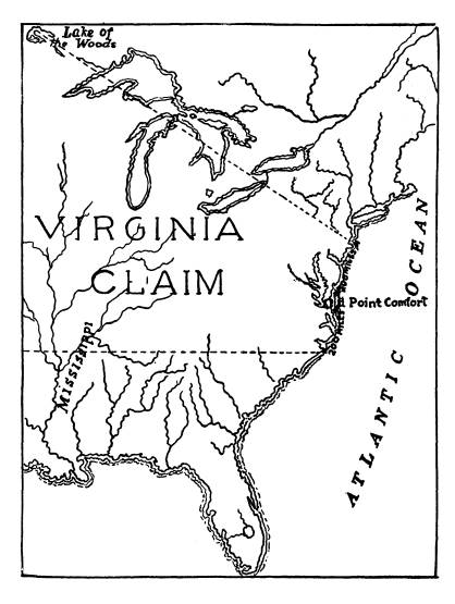
This was regarded by Virginia as a
violation of her rights
under her charter of 1609 from the
British crown, being as
it was, prior in date to such treaties,
and which as to extent, was
as follows: "Situate, lying and
being in that part of America
called Virginia from the point of land
called Cape or Point
Comfort all along the sea coast to the
northward two hundred
miles, and from the said Point or Cape
Comfort, all along the
sea coast to the southward two hundred
miles, and all that space
and circuit of land lying from sea to
sea, west and northwest."
The claims of other colonies are here
omitted for the reason
that no actual jurisdiction over our
valley was ever exercised
by them. It may be proper, however, to
state that the charters
of some of them overlapped in area, that
of Virginia, notably
Connecticut, whose charter of 1662
nominally embraced all the
present state of Ohio north of the 41st
parallel of north latitude;
but in 1786 she ceded to the general
government all of the
same west of the west lines of what are
now Huron and Erie
counties.
Virginia's statesmen and jurists
interpreted her charter of
1609 as granting all that vast domain,
between the Atlantic and
Pacific, bounded south by a line running
west from the south
point in the sea coast line named in
said charter, and on the
north by a line running northwest from
the north point in said
sea coast line. This interpretation was
acted upon by Virginia
and jurisdiction exercised by her from
the beginning, and until
modified as to western limits of the
Mississippi by the treaty
of 1763 and subsequently until her
cession in 1784 to the general
|
The Evolution of Sandusky County. 151 |
|
|
152
Ohio Arch. and Hist. Society
Publications.
government of her western territory.
These lines as claimed by
Virginia would be about at right angles
to the trend of the
coast lines described in the charter; an
argument it is believed
supporting the Virginia interpretation
as to territorial extent.
Immigrants refused to obey the
proclamation, ordering
them to abandon their over mountain
settlements; while at the
same time others were encouraged to
follow them over the
prohibited line. Virginia insisted upon
her charter rights and
continued to assert jurisdiction west of
the mountains by creating
counties, as we shall see, and by other
acts.
England's restrictive policy was also
insisted upon by her
and further emphasized by what was known
as the Quebec Act
in 1774, by which the province of Quebec
was extended south to
the Ohio river and west to the
Mississippi, trial by jury in civil
cases was abolished, and the French
system of laws restored.
Thus the region embracing our valley
became subject to the
jurisdiction of a government under
English dominion, with the
same capital as when under that of
France. England's unwise
and oppressive policy toward the
Colonies, brought on the Revo-
lutionary war; the Quebec Act became
inoperative during that
struggle as did all other claims of
England to dominion, in the
territory of the Northwest, and
resulted, as we all rejoice to
know, in England's loss, not only of the
disputed territory west
of the mountains, but also of all her
American colonies. By the
Paris treaty of peace, September, 1783,
which followed, thir-
teen colonies were acknowledged to be
free, sovereign and inde-
pendent states, and "all claim to
government, proprietary and
territorial right of the same and every
part thereof," was re-
linquished by England to them.
The long existing disputes among the
Colonies as to bound-
aries and extent of territory granted to
certain of them by
their respective charters now became
acute; and for a time
threatened the peace of the country; but
they were all finally set-
tled by cessions to the general
government, upon satisfactory con-
ditions, or such as were acquiesced in
by all the states; and thus,
except the Connecticut Western Reserve
and the Virginia Mili-
tary Lands, all the territory bounded by
the lakes, the Ohio
and the Mississippi became the public domain and by the ordi-
The Evolution of Sandusky
County. 153
nance enacted by Congress, July 13,
I787, was organized as
the Northwest Territory.
UNDER VIRGINIA.
In the dispute between England and
France the chartered
rights of the English Colonies, as
between the Colonies and the
Mother Country, were not directly
involved; indeed the war
which resulted in favor of England may
be claimed as waged
by her mainly in behalf of her Colonies.
Virginia had in the meantime pushed her
settlements west-
ward, but had not till early in the
eighteenth century crossed the
Allegheny mountains.
SPOTTSYLVANIA COUNTY.
The first official exercise of
jurisdiction by Virginia over
the region west of the Alleghenies was
the Act of her Colonial
Assembly (4 Henings Virginia Statutes at
Large 450) creating
the county of Orange in 1734, taking the
same, in part, from
that of Spottsylvania which had been
formed in 1720, but whose
western limits were indefinite and did
not extend beyond the
Alleghenies. It was, however, the first
county organization to
extend west of the Blue Ridge. The first
passage over this
range, by the white man, was claimed to
be that of the romantic
adventure of Governor Spottswood in
August and September
of 1716, when he and a party of
gentlemen, including members
of his staff numbering in all fifty
persons, journeyed, on horse
back by way of the Upper Rappahannock
river, with pack-
horses laden with provisions for the
expedition. After thirty-
six days they had "topped the
mountain" and reached the famous
valley later named the Shenandoah, and
crossing to the west bank
of the river, the governor named it
"Euphrates," and there took
formal possession in the name of King
George First, then of
England, by burying a bottle containing
a written inscription to
that effect. The occasion was there
celebrated with much con-
viviality in drinking and banqueting by
the governor and his
gay party. Eight weeks were consumed and
440 miles traveled
in going and returning. The governor
commemorated the jour-
ney by creating the "Knights of the
Golden Horse Shoe," having
154
Ohio Arch. and Hist. Society Publications.
reference to the careful shoeing of the
horses required to enable
them to climb the mountain. He caused
small golden horse shoes,
set with jewels, to be made in London,
inscribed with the legend:
sic juvat transcendere montes, (thus it
is a pleasure to cross
the mountains) which he distributed to
his companions of the
expedition.
ORANGE COUNTY.
In the Act of the Assembly creating the
county of Orange
and defining its boundaries, westward,
are found these words:
"Westerly by the utmost limits of
Virginia," which, of course,
according to Virginia's construction of
her charter of 1609, em-
braced all of the present state of Ohio,
and much more. It
was claimed by Virginia as including all
west of the Blue Ridge,
extending southward to Tennessee and
covering what is now
Kentucky.
AUGUSTA COUNTY.
The immense domain of Orange county was
on November
10, 1738, (5
Hening 79) divided by the Assembly, and the portion
west of the mountains formed into the
two counties of Augusta
and Frederick. The latter embraced
comparatively a small ter-
ritory extending from the Potomac river
to the northern
boundary of the present county of
Rockingham, and a little
further westward. The remainder formed a
part of Augusta,
which county extended south to the
borders of Virginia, west
and northwest to the utmost limits of
the territory of Virginia,
and contained what is now Kentucky,
Ohio, Indiana and Illinois
and consequently embraced our Sandusky
valley and brought it
within the nominal jurisdiction of
Augusta county. Staunton
became the county seat, and courts were
held there before the
Revolutionary War, and also at
Pittsburg, which was in Augusta
county.
BOTETOURT COUNTY.
On November 10, 1769 (8 Hening 396)
Botetourt county
was formed by Act of the House of
Burgesses by cutting off
from Augusta all that part lying south
and west of the North
river, by a line west, bearing north 55
degrees, beginning at the
Blue Ridge where that river flows
through the same near the
The Evolution of Sandusky
County. 155
site of Lexington in the present county
of Rockbridge, Va.,
and running to the confluence of the
south river with the north
branch of the James and up the James to
the mouth of Kerr's
Creek and up that creek to the mountain;
which line of separation
was by the provisions of the act
mentioned, authorized to be
continued westward as far as the courts
of the two counties
might thereafter order. The records of
the court of Augusta
April 20, 1770, and of Botetourt, June 3, 1770,
show an extension
of this line westward bearing north 55
degrees, to a point de-
scribed as the "west side of
Anthony's Creek Mountain," which
is in what is now the northeast part of
Greenbrier county,
West Virginia. There seems to be no
record of legislative
enactments or of court orders further
extending this line to be
found. That the act of the assembly
creating the county of
Botetourt contemplated its extension to
the "waters of the Mis-
sissippi," is apparent from its
exemption from the payment of
certain levies, the people situated on
the "waters of the Mis-
sissippi in said county of
Botetourt." It is further apparent
from the two acts of the Virginia
Assembly in forming Fincastle
county from Botetourt (8 Hening 600) in
1772, and in dividing
Fincastle into the three counties of
Kentucky, Washington and
Montgomery, in 1776 (9 Hening 257) that
at the dates of those
enactments, the legislature must have
considered that Botetourt,
their source, did in fact, embrace the
territory described in those
acts. While the boundaries of Fincastle
are somewhat vague,
as defined in the act forming the same,
yet if studied in con-
nection with the act dividing the same,
as before mentioned, into
the counties of Kentucky, Washington and
Montgomery, it will
be found, in addition to the
southeastern portions thereof com-
prising the counties of Washington and
Montgomery, to have
embraced territory west and south of the
west side of Anthony's
Creek mountain, and bounded west and
northwest by the Ohio
river, to the Mississippi, and south by
the state of Tennessee,
as it will be seen that this county of
Kentucky as then bounded
was nearly identical with the state of
Kentucky as finally formed
and admitted into the union.
Returning in our sketch to Augusta
county, it will be found
that in 1776 the counties of Ohio,
Yohogania and Monongalia
156 Ohio Arch. and Hist. Society Publications.
were formed from that part of Augusta
lying between the
Alleghenies and the Ohio river, thus
cutting off from Augusta
county and embraced territory west and
south of the "west side
of Anthony's Creek mountain,"
leaving the same outside of any
county organization all that vast extent
of country northwest
of the Ohio river, south of the lakes
and east of the Mississippi,
a "great and terrible
wilderness," roamed over and dominated
by savage tribes of the west in their
murderous incursions against
the Virginia and Pennsylvania
frontier. Rightfully, as she
claimed, it was within the jurisdiction
of Virginia, but this was
disputed by the mother country, whose
government as we have
seen, claimed it for the benefit of the
Indians. Since the treaty
of Paris (1763)and prior to that France
had taught the Indians
that their title to this region was
valid to the Ohio river.
ILLINOIS COUNTY.
In 1778 all the region just described
was conquered from
England by Virginia under General George
Rogers Clarke,
and in October, 1778, the legislature of
Virginia established
from it the county of Illinois with
Kaskaskia on the Mississippi
as the chief seat of justice and Cohokia
and Vincennes, sub-
ordinates. Thus the present state of
Ohio with our Sandusky
Valley was again brought within a county
organization and
subject territorially considered at
least to the jurisdiction of
the county of Illinois, which embraced
all the chartered limits of
Virginia northwest of the Ohio river
east of the Mississippi,
and so remained in so far as
governmental relations existed,
until March, 1784, when Virginia ceded
to the general govern-
ment, subject to certain conditions, all
her rights to dominion
northwest of the Ohio river.
Notwithstanding the conquest from Great
Britain by General
Clarke, and the organization of the
County of Illinois by Vir-
ginia, from the conquered territory, the
Indians still dominated
the Ohio country as its chief occupants
and would listen to no
terms of settlement which did not grant
them valid title, ex-
tending to the Ohio river. In the
several attempted peace nego-
tiations with them, their ultimatum was
title as thus claimed.
This demand not being granted
hostilities against the frontiers
The Evolution of Sandusky
County. 157
continued with unabated fury. Murderous
incursions by the
Miamis and confederated tribes from the
Maumee, and western
country, and by the Wyandots and their
immediate allies from
the Sandusky valley, were frequent,
attended with characteristic
savage cruelties. In the meantime a number of ineffectual
attempts to conduct expeditions into the
enemies' country were
made.
CRAWFORD'S CAMPAIGN.
Finally, in 1782, an expedition from the
frontiers, com-
manded by Colonel William CRAWFORD, was
organized, and four
hundred strong, moved against the
Wyandots and allies of the
Sandusky country, started from Mingo
Bottoms the 25th day
of May, and on the 4th of June, came
upon the enemy near
the present site of Upper Sandusky,
Wyandot County, where a
battle ensued in and around an island of
timber in the plains,
since known as "Battle
Island."
The first day's conflict seemed to
result in favor of Colonel
CRAWFORD's force. Preparations were made
by him for a renewal
of the engagement the next day, with
confident expectations of
a victory, but the enemy being
reinforced on the second day,
by the arrival of about two hundred
Shawnees from the south,
and British troops known as Butler's
Rangers from Detroit,
coming by the way of the Sandusky Bay
and River to Lower San-
dusky and thence to the scene of
conflict, so greatly increased
the force of the enemy that the intended
renewal of attack was
deemed too hazardous and a retreat
instead was decided upon
which commenced on the night of June
5th, greatly harassed
by the pursuing savages, until the site
of the present town of
Crestline was reached, June 6th, where
pursuit ceased.
Space will not permit a narration of the
thrilling incidents
of this disastrous retreat, connected as
it was, with the capture
of the brave Colonel CRAWFORD, who had
become separated from
the main force, and his inhuman torture
and tragic death by
burning at the stake, June 11th, 1782. A
monument stands
where his torture and death occurred,
near Carey on the east
bank of the Tymochtee.
John Sherrard, great-grandfather of
Robert Sherrard, of
Fremont, was in that battle and rendered
conspicuous service as
158
Ohio Arch. and Hist. Society
Publications.
a soldier in the fight, and in aiding
the wounded, by carrying
them water in his hat from a pool caused
by an upturned
tree.
UNDER FEDERAL DOMINION.
As we have seen, after the close of the
Revolutionary War,
and the cessions by the Colonies to the
general government of
their respective claims in the
northwest, our valley became sub-
ject to the jurisdiction of the
northwest territorial government.
Indian depredations, however, still
continued, founded upon
their claim of title, extending to the
Ohio, as before asserted by
them. Notwithstanding the stipulations
in the treaty of Paris,
1783,
by Great Britain to surrender all military posts within
the territory ceded by that treaty,
those at Mackinac, Detroit,
and the Ohio posts on the Maumee, and on
the Sandusky Bay,
were still garrisoned by the British,
under the pretense, as
claimed, of regarding them as a
guarantee by the Americans to
carry out a stipulation in the treaty to
pay certain debts owing
by them to the British. Their real
motive, however, was be-
lieved to be in order to keep on
friendly terms with the Indians
by carrying on trade, especially in
furs, with them, exaggerate
their grievances, and goad them on to
hostile depredations against
the Western colonists, with assurance of
British sympathy and
support, in the hope that the Western
country might finally
be lost to the United States and
restored to Great Britain as a
colonial dependency. British aid
subsequently given the savages
in their repeated aggressions against
the settlers, leaves no doubt
as to the real purpose of Great Britain
in thus wrongfully occu-
pying these posts.
HARMAR'S EXPEDITION.
The United States, at first as the
Colonies had done previ-
ously, resorted to negotiations with the
savages, which proving
unavailing, General Harmar, under
directions of General Wash-
ington, President, in the fall of 1790,
with an army of thirteen
hundred men, marched from Cincinnati
into the Indian country,
and at the confluence of the Rivers St.
Joseph and St. Mary's
(Fort Wayne) a large detachment of his
forces under command
of Colonel Hardin, encountered a large
body of savages led by
the famous chief, Little Turtle; a
severe engagement ensued.
The Evolution of Sandusky
County. 159
resulting in the defeat of the Americans
with great loss in killed
and wounded. The expedition was an utter
failure.
ST. CLAIR'S DEFEAT.
President Washington, inspired with
great anxiety for an
effective prosecution of the Indian war,
caused a new army
to be organized in every way superior to
the former, under the
command of Gov. St. Clair; it was
composed of three regiments
of infantry, two companies of artillery,
one of cavalry, and six
hundred militia men. With this force St.
Clair invaded the
enemies' country, and on November 4,
1791, at the present site
of Fort Recovery, in Mercer county, was
suddenly attacked
by the whole force of the northwestern
tribes and disastrously
defeated with a loss of six hundred men
and thirty-five officers
killed, while two hundred men and
twenty-five officers were
wounded. So St. Clair's expedition was
also a complete failure.
FALLEN TIMBERS.
The next year General Anthony Wayne was
appointed to
the command of the army of the
Northwest. In the spring of
1793, unsuccessful negotiations for
peace were held with the
tribes at the rapids of the Maumee,
pursuant to offered media-
tion of Great Britain, now believed to
have been insincere. In
the meantime, General Wayne was
perfecting his plans for a
decisive campaign against the combined
tribes, which when fully
organized, was conducted by him along
practically the same route
as that of St. Clair in 1791. On August 20th,
1794, his forces
consisting of about one thousand strong,
met the enemy at the
rapids of the Maumee, at a place known
as "Fallen Timbers,"
where a severe engagement took place,
resulting in an over-
whelming victory for the Americans. The
enemy, about sixteen
hundred strong, including perhaps two
hundred British volun-
teers and regulars, was under the
general command of Blue
Jacket. Tecumseh led the Shawnees,
Little Turtle, the Miamis;
who led the Wyandots, does not appear,
but several of their
chiefs were in the engagements, among
whom was the great
chief Tarhe, the Crane, of Lower
Sandusky, who was severely
wounded in that engagement.
160 Ohio Arch. and Hist. Society
Publications.
TREATY OF GREENVILLE.
Wayne's victory and events succeeding
it, led to the treaty
known as the Treaty of Greenville of
August 3, 1795, signed
by Anthony Wayne and by the several
sachems and war chiefs
of the Northwestern tribes of Indians.
The signature of Tarhe, the Crane, of
the Wyandots, is the
first to appear next under that of
General Wayne. Indian
hostilities ceased from the time of this
treaty for a period of
ten years, or until the uprising of the
tribes under Tecumseh,
immediately preceding the war of 1812
with Great Britain, in
which he was also a conspicuous ally of
the British. The Wyan-
dots of the Sandusky valley did not join
Tecumseh, nor take
part against the Americans in the war of
1812, but on the con-
trary were friendly and adhered to us
throughout that war,
as shown by the report of General
Harrison to the Secretary
of War, March, 1814. The Wyandots at
Detroit, however,
under the influence of their chief
"Walk in-the-Water," sided
with Tecumseh and allied themselves with
the British.
The first treaty made with the Indians,
affecting title to
our valley, was that with the Wyandots,
Delawares and Ottawas
at Fort McIntosh January 21, 1785, by which
the boundary
line between the United States and the
Wyandot and Delaware
Nations was to begin at the mouth of the
Cuyahoga river (Cleve-
land) and run thence up that river to
the portage between that
and the Tuscarawas branch of the
Muskingum, then down the
forks at the crossing place above Fort
Laurens; then westerly to
the portage of the big Miami, which runs
into the Ohio, then
along said portage to the Maumee river
and northerly down
the southeast side of the same to its
mouth, (Toledo) thence
along the south shore of Lake Erie to
the mouth of the Cuya-
hoga river where it began (Cleveland).
All the land contained within these
lines was allotted to the
Wyandot and Delaware Nations, "to
live and hunt on" and
to such of the Ottawa nation as then lived
thereon. There were
certain reservations for the use and
under the government of
the United States for trading posts.
Among these were a
six mile square tract on the Sandusky
Bay, "where a fort
The Evolution of Sandusky
County. 161
formerly stood" and a two mile
square tract on each side of
the lower rapids of Sandusky River.
All the lands east, south and west of
the described line,
were to belong to the United States.
This treaty in substance
was renewed or reaffirmed on the 9th day
of January, 1789,
at Fort Harmar, the Chippewa and
Patawatian nations joining
therein.
These treaties, however, were never
fully carried into effect,
on account of the continued Indian
hostilities, instigated by the
principal western tribes, who claimed
that to make a treaty
binding, all the tribes must join
therein, and that inasmuch as
they had not taken any part in these
treaties they were not
bound by them. As we have seen, the
treaty of Greenville
was finally signed by all the warring
tribes and brought peace
between the settlers and Indians.
HAMILTON COUNTY.
The first county organization under
Federal government
embracing our valley was that of
Hamilton county, which came
into existence by the proclamation of
the territorial governor,
Arthur St. Clair, January 2, 1790. It did not,
however, at first
extend this far north, but on February
11, 1792, the boundaries
of Hamilton county were extended to the
then north boundary
line of the territory, and included the
territory which is now
Sandusky County. On the west it was
bounded by Knox County,
in northwest territory now parts of
Indiana and Michigan, on
the east by a line which would be the
west line of Huron and
Erie Counties prolonged to the north
boundary of Ohio. (Vol.
2, page 310, The St. Clair Papers.)
WAYNE COUNTY.
"In 1796 Capt. Porter with a
detachment of troops from
Gen. Wayne's Army took possession of
Detroit and flung to
the breeze the first American banner
that ever floated over
Detroit." On August 15, 1796,
Winthrop Sargent, Secretary
of the Northwest Territory, the governor
being as he supposed,
absent from the territory, by
proclamation formed the county
of Wayne, with Detroit as the seat of
justice. The absence
Vol. XXIV-11.
162
Ohio Arch. and Hist. Society
Publications.
of the governor would confer authority
upon the secretary to
so act. This county as formed embraced
all the northwestern
part of Ohio, west of the Cuyahoga and
Tuscarawas rivers to
Fort Laurens, a large tract on the
northwestern part of Indiana
including Fort Wayne, a part of
Illinois, including the site of
Chicago, and the whole of the territory
of Michigan. It was
larger in extent than the present states
of Ohio and Michigan.
Peter Audrian was Judge of Probate,
Register of Deeds, and
Justice of the Peace of this vast
county, which, of course, in-
cluded the Sandusky valley. All law
suits between inhabitants
of our valley, within the jurisdiction
of a Justice's Court, would
have been required, by law to be in the
Court of Peter Audrian
as such Justice. Probate of wills and
settlement of estates were
also within his exclusive jurisdiction!
Thus it appears that the
present county of Sandusky was then a
part of Wayne County,
which had Detroit as the county seat.
NORTHWEST TERRITORY DIVIDED.
An Act of Congress, May 7, 1800, to take effect
July 4,
following, divided the Northwest
Territory, and created the ter-
ritory of Indiana, making Vincennes the
capital thereof. The
dividing line began at the Ohio,
opposite the mouth of Ken-
tucky river, thence to Fort Recovery,
and thence north to the
north boundary line of the United
States.
This division still left our region,
with Detroit, in Wayne
County. By Act of Congress April 30, 1802,
known as the
"Enabling Act" authorizing the
Ohio division of the North-
west Territory to form a Constitution,
preparatory to admission
as a state, the region including Detroit
was attached to Indiana
territory. No delegates from Wayne
County to the Ohio Con-
stitutional Convention were admitted,
notwithstanding its inhabi-
tants were counted to make up the
required population. Our
valley thereby once more, together with
other territory, became
outside of any county organization.
FRANKLIN COUNTY
was formed by Act of the Legislature
March 30, 1803 (V. 1
p. 26) with the seat of justice at
Franklinton (Columbus)
The Evolution of Sandusky
County. 163
and would seem to have embraced the
Sandusky valley; but
there is a question whether its north
boundary line was intended
to be the "Indian boundary"
line or the State line. In the Act
referred to, after defining the west
line we find these words:
"thence north with the said line
until it intersects the State line,"
and then reads as follows: "thence
eastwardly with the said
line to the northwest corner of
Fairfield County." Now it
is apparent that this last described
line must have been a
diagonal one to reach the point
mentioned and could not have
been the State line. So it would seem
that the Legislature must
have confused the State line with the
Indian boundary line;
and further, when the County of Delaware
was subsequently
formed by being taken from the north
part of Franklin (1808)
its northern boundary was defined to be
the Indian boundary
line.
It is hardly supposable that any portion
of Franklin would
have been purposely left detached from
the main part, with
Delaware lying between the main and
detached portion. It
seems, however, that there was some
uncertainty, with reference
to the question of boundary, for in
1809, the legislature annexed
to Delaware "all that part of
Franklin County lying north
of Delaware." Did this annexed
territory extend to the north
boundary line of the State?
DELAWARE COUNTY
was formed, as we have seen, in 1808
(Vol. 6, p. 29) and unless
our valley was embraced in Franklin
County when first formed
it remained outside of any county
organization from April 30,
1802,
until 1809, when the addition to Delaware which is believed
to have embraced it was made as before
shown.
RADNOR TOWNSHIP.
That this annexed territory was intended
to and did include
our region, would appear from the fact
that the County Com-
missioners of Delaware County on April 29, 1811,
as recorded
in their Journal Vol. 1, p. 35,
passed the following resolution:
"Resolved by the Board of
Commissioners of Delaware
County in conformity to a petition from the white inhabitants
164 Ohio Arch. and Hist. Society Publications.
of Sandusky and by the verbal request of
some of the inhabitants
of Radnor township, that all that part
of country commonly
known and called by the name of Upper
and Lower Sanduskys
shall be and now is attached to Radnor
township enjoying town-
ship privileges so far as is agreeable
to law."
HURON COUNTY
was organized January 31, 1815, (Vol.
13, p. 113). Section 3
of the Act organizing the same attached
to Huron County for
judicial purposes, "all that part
of the State of Ohio lying west-
wardly of Huron County, northwardly of
the south line of the
Connecticut Reserve extended westwardly
and eastwardly of the
east line of Champaign County, extended
due north to the north
line of the State." This included
our valley. That the same
had been regarded as in Delaware County
as before stated is
evident from the further provision of
Section 3, "that all suits
and actions which shall have been
commenced within the above
described territory shall be prosecuted
to final judgment and
execution in Delaware County as though
the territory had not
been attached to Huron County."
Avery was then the county
seat of Huron County. In 1818 Norwalk
became the seat of
justice of that county.
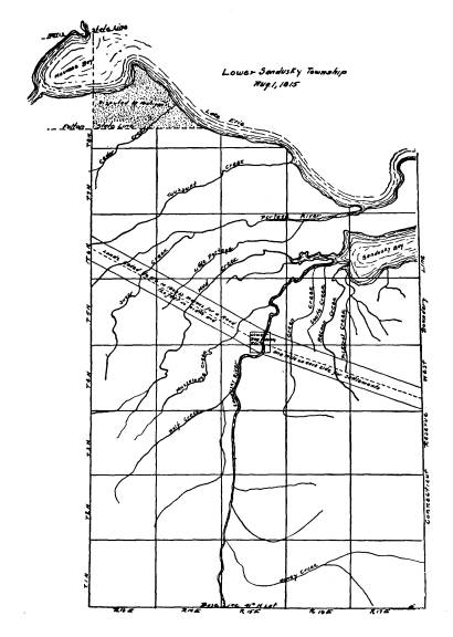
LOWER SANDUSKY TOWNSHIP
was formed by County Commissioners Caleb
Palmer, Charles
Parker, and Eli Barnum, of Huron County,
at their first meeting
for the county which was held at the
house of David Abbot,
August 1st, 1815, (Journal 1, p.
1).
This township, organized as it was
before the organization
of Sandusky county, embraced "all
that part of Huron county
west of the 24th range of the
Connecticut Reserve" namely:
All lands between the west line of Huron
and the east lines of
what are now Hancock, Wood and Lucas
counties, including
Oregon and Jerusalem townships, now in
Lucas, and all north
of the south boundary line of Seneca
county to Lake Erie. The
first election for township officers of
this immense township
was held in Lower Sandusky August 15,
1815, at the house of
Israel Harrington on the west side of
the river. The officers
|
The Evolution of Sandusky County. 165 |
|
|
166 Ohio Arch. and Hist.
Society Publications.
elected were, Israel Harrington, Randall
Jerome and Jeremiah
Everett (father of Homer Everett)
trustees; Isaac Lee, clerk;
Morris A. Newman and William Ford,
overseers of the poor,
and Charles B. Fitch and Henry Dubrow,
appraisers. Thus it
will be seen that this township included
within its limits the pres-
ent counties of Seneca, Sandusky, Ottawa
and parts of Lucas
and Erie.
CROGHAN TOWNSHIP.
In the Huron County Commissioners' Journal
No. 1, of their
proceedings is the following:
"May 18th, 1819, Commissioners met,
towit: Joseph Strong
and Bildad Adams. A petition was
presented for a new town-
ship, therefore ordered that all that
tract lying west of the fire
lands (Huron County) and east of the
Sandusky river is hereby
set off and made a separate township by
the name of Croghan."
Croghan township was formed after the
treaty at the foot
of the rapids of the Maumee was made, by
which the title of the
Indians was extinguished to all lands
within the State of Ohio,
then claimed by them, east of the west
line thereof, and north of
the Greenville treaty line. This treaty
was in the nature of a
purchase, and the lands included were
known as "the new pur-
chase." The consideration passing
from the United States,
was as follows: To the Wyandots, who
were the chief Indian
parties concerned as to the Sandusky
Valley, a perpetual annuity
of $4,000, a tract of land twelve miles
square at Upper San-
dusky and a tract one mile square on
Broken Sword Creek (a
tributary of the Sandusky river); to the
Senecas, $500; to the
Shawnees, $2,000; to the
Pattawatimies annually for 15 years,
$1,000; to the Chippewas annually for 15
years, $1,000; and to
the Delawares, $500, but no annuity; to
the Senecas, thirty
thousand acres on the east side of the
Sandusky river, in what
is now Sandusky and Seneca counties,
about one-third of which
was in Sandusky, beginning at a point
opposite the mouth of
Wolf Creek, running thence east through
the north parts of
sections 29-28-27-26 and 25 in Ballville, and
sections 30-29-28,
and into west part of section 27 of
Green Creek Townships,
thence south to the Seneca County line.
It also contains the
1,280 acre tract reserved to Elizabeth
Whitaker "on the west side
|
The Evolution of Sandusky County. 167
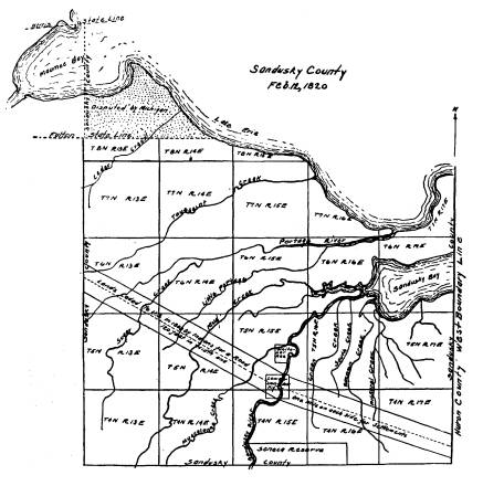
of Sandusky river below Croghansville," and the 160 acre tract reserved to Sarah Williams, Joseph Williams and Rachel Wil- liams Nugent "on the east side of the Sandusky river below Croghansville, and to include their improvements at a place called Negro Point." By a subsequent treaty at St. Mary's September 17th, 1818 (7 Stat. p. 179) there was added to the Senecas, on the south side of the above reservation a tract of ten thousand acres, and to the Wyandots was ceded a tract about twelve miles square in northeast corner of Seneca County. On February 12th, 1820, "the new purchase" was carved into fourteen new Counties. Sandusky was one of the fourteen |
|
|
168
Ohio Arch. and Hist. Society Publications.
to thus appear among the sisterhood of
Counties of the great
state of Ohio. Croghansville was the
temporary seat of justice,
where public matters were conducted for
a little more than two
years, or until May 23rd, 1822, when the permanent county
seat was located in the "Town of
Sandusky," where by the
names successively of Sandusky, Lower
Sandusky and Fremont
it has remained.
From the time that the seat of justice
was permanently
located in the town of Sandusky,
Croghansville has seemed to
have waned in importance as a separate
village and to have been
gradually absorbed by the former. In
1827 that portion of
Croghan township embracing the village
of Croghansville was
annexed to Sandusky township by action
of the County Com-
missioners.
In 1829
the territory of both villages by Act of
the State
Legislature was incorporated into one
village by the name of the
"Town of Lower Sandusky." The
village of Croghansville
thereby became extinct, in name. When
Lucas county was
formed, in 1835, that portion of the
territory of Sandusky
county, as originally erected, marked on
the map as "disputed
by Michigan," was made a part of
Lucas county.
In 1838 when Erie county was erected all
that portion
of original Sandusky county lying along
the south shore of
Sandusky Bay, bounded east by Huron
county and south by
the north line of Townsend township to
the northwest corner
thereof was made a part of Erie county.
March 6, 1840, Ottawa county was
created, being taken
mostly from Sandusky and greatly
diminishing its area, cutting
off all that part included within the
following boundaries:
commencing at a point two miles north of
the southeast corner
of the surveyed township number sixteen,
called Bay township,
running thence west on section lines to
the western boundary of
the county; thence north to the Lucas
county line; thence east six
miles; thence north to the Michigan
state line; thence with said
line until it intersects the line
between the British and American
governments in Lake Erie; thence down
the lake with said line,
so that a line to the mouth of Sandusky
Bay will include Kelley's
Island; thence up the Sandusky Bay to
the place of beginning.
|
The Evolution of Sandusky County. 169
March 23, 1840, the legislature restored to Sandusky county, all that part of Clay township in Ottawa, commencing at the southwest corner of section twenty-three; thence north to the northwest corner of section eleven and thence west to the Wood county line. This addition forms the north part or jog of Woodville township. The name of the county seat was changed from Lower San- dusky to Fremont, at the October term 1849 of the Common Pleas Court. July 18, 1866, the population of Fremont having reached more than five thousand inhabitants, it was by state authority as then required, duly declared a city of the second class. Fremont, Ohio. |
|
|