Ohio History Journal
Old Fort Sandoski of 1745 and The
Sandusky Forts. 375
hoga River is a mere assertion without
any foundation in fact.
Neither Colonel Whittlesey, Mr. A. T.
Goodman nor Judge Bald-
win, long officers of the Western
Reserve Historical Society at
Cleveland, on the Cuyahoga River, and
all extremely anxious to
prove the importance of their own
locality, ever thought of
claiming the Cuyahoga River for the
White River.
From the foregoing, it appears that Mr.
Hanna's criticism
betrays such carelessness in the use of
data which were plainly
before his eyes that no confidence can
be placed in his general
statements when unsupported by definite
references and that,
when definite references are made, it is
not likely that he has
considered them carefully enough to give
them proper interpre-
tation.
The experiences of Secretary Randall in
his "History of
Ohio," in dealing with the
sophistries of Mr. Hanna in trying
to prove that LaSalle did not discover
the Ohio, brings out Mr.
Hanna's defects of historical judgment.
Reviewing Hanna's
argument in the case of LaSalle, Randall
says, "they are mainly
negative and leave LaSalle's claim still
unrefuted with the pre-
ponderance of evidence decidedly in his
favor, and the judgment
of Parkman still unreversed that LaSalle
discovered the Ohio."
A critic who can in a nonchalant manner
dismiss the con-
clusions of Parkman, discredit the
conversations published by
Margry, doubt the correctness of
LaSalle's "Memorial to Fron-
tenac," think that Joliet's map was
a species of forgery, and
that the opinion of Whittlesey, Goodman
and Baldwin of the
Western Reserve Historical Society, are
of no value in the
history of the regions to which they
each give their close atten-
tion, is not one whose opinions are to
be taken without investiga-
tion.
STATEMENT BY THE EDITOR OF THE
QUARTERLY.
The Editor is responsible for the
publication, without cor-
rection, or comment, in the last
QUARTERLY of the article
by Charles A. Hanna making severe
reflection on the Presi-
dent and Trustees of the Ohio State
Archaeological and His-
|
376 Ohio Arch. and Hist. Society Publications. |
|
|
torical Society, and criticising in unmeasured terms the culmination of one of the most fruitful re- searches ever made by the Society, the discovery of the DeLery Jour- nals and their partial publication under the title of "Old Fort San- doski of 1745 and the Sandusky Country" in the QUARTERLY of October, 1908, and "Old Fort Sandusky and the De Lery Por- tage" in October, 1912. It would have been but proper to have submitted Mr. Hanna's ar- ticle to the author of this series and to the speakers at the dedica- tion of the tablets, before publish- ing it; to have given them an op- portunity to reply. The Editor also regrets the typographical error in the article on the De Lery Portage, giving a wrong date to Evan's map-it should have been 1755 and not 1775; and also the inscriptions placed under the fac-simile of the four tablets, pages 363, 365, 367, and 369, Vol XXI, all of which were tablets on the Fort Sandoski monument. They were erron- eously ascribed to the Harrison Perry Embarkation Monument on the shore of Lake Erie. Unfor- tunately there were no illustrations of the tablets on the latter monu- ment, erected by the Daughters of the American Revolution and the Ohio Daughters of the War of 1812. |
Old Fort Sandoski of 1745 and The
Sandusky Forts. 377
In view of the action of the members of
the Ohio State
Archaeological and Historical Society at
the last annual meet-
ing in May, that the secretary be
authorized to have prepared
a formal correction of Mr. Hanna's
communication on the San-
dusky Forts, it is perhaps only
necessary to refresh the minds
of the members by quoting again the
authorities used in the
article on "Old Fort Sandoski of
1745" published five years
ago. I therefore reproduce a part of
Evans' and of Mitchell's
maps, both of 1755, and beg to call
attention to the following:
First-The late A. T. Goodman, for many
years secretary
of the Western Reserve Historical
Society, in Tract No. 4, pub-
lished Jan. 1871, has the following
references to Fort Sandusky:
"English traders first made their
appearance in the Ohio coun-
try in 1699-1700. From that time until 1745 we frequently
hear of them at various towns and
stations. In 1745 they built
a small fort or blockhouse among the
Hurons on the north side
of Sandusky Bay. In 1748 they were
driven off by a party of
French soldiers from Detroit. Prior to
1763 the English in
Ohio were very few in comparison to the
French."
Second-In Tract No. 6, in "Papers
Relating to the First
White Settlers in Ohio," also by
Mr. Goodman, published in
July, 1871, occurs the following
reference to Fort Sandusky.
"As early as the year 1745 English
traders penetrated as far as
Sandusky, or 'St. Dusky,' and
established a post on the north
side of the bay near the carrying place
or portage from the
Portage River across the peninsula. They
were driven away
by the French probably in 1748 or
1749."
Third-Canadian Archives: Nov. 14, 1747,
M. de Longueuil
wrote: "Nicolas's band at Sandoske
are as insolent as ever, the
chief never ceasing his work to get
allies-Nicolas will draw the
English to him and facilitate their
establishments all along Lake
Erie." March 20, 1748. "The
conduct of Nicolas is suspicious.
The English in Philadelphia came there
twice during the winter
and were well received. The scalps of
the Frenchmen killed
near the fort of the Miamis (now Ft.
Wayne) have been car-
ried there (Sandoske)." May 28,
1748. M. de Longueuil re-
ports that a faithful Indian who had
gone to gather up the
Indians who had deserted from the
village of Otsandoske (Nic-
|
378 Ohio Arch. and Hist. Society Publications. |
|
|
Old Fort Sandoski of 1745 and The Sandusky Forts. 379
olas's village near the mouth of the
river) reported that Nicolas
with 119 warriors of his nation, women and
children and bag-
gage, after having burned the fort and
the cabins of the village,
had taken the route for White River.
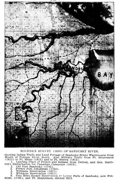
Fourth-Col. Charles Whittlesey, the
learned president of
the Western Reserve Historical Society
of Cleveland wrote in
Tract No. 13, published in 1873, as
follows on the Fort at San-
dusky:
On Mitchell's Map, London, 1755, and on
that of Evans,
Philadelphia, same date, there is a
"fort" laid down on the north
side of the bay, near the mouth. It is
much more probable that
this fort, house, or post, was situated
where the trail or portage
path came out on the bay, across the
neck from the Portage or
Carrying River, at Ottawa. The English
government had no
fortifications there at that time.
Mitchell states that the fort
on the north side, meaning post, was
"usurped by the French
in 1751." Fort "Juendat,"
on Evan's map, is placed south of
the bay and east of Sandusky River,
"built in 1754." This was
a French establishment for trade,
perhaps with a stockade for
defense against the English, and their
Indian allies. When
the English got possession of Lake Erie
and its tributaries in
1760,
a military post was planted somewhere on
Sandusky Bay.
Ensign Paully and a squad were captured
there in 1763, at the
uprising of Pontiac's conspiracy, and
most of them murdered
on the spot. The natural point for a
fort or a trading post, is
on the north side of the bay, west of
the plaster beds, where
the trail from Portage River touched the
shore. This was the
route from Detroit into the Ohio
country, and commanded the
mouth of Sandusky River. Bradstreet's
camp was here. It is
also probable that Ensign Paully's
blockhouse, or stockade, was
at the same place. It was only about two
miles along the trail
northward to Lake Erie, from where all
parties moving in
canoes could be observed, and
intercepted at the mouth of the
bay. To the west, around the bay, the
ground is low, swampy,
and very difficult of passage, even by
Indians, in its primitive
condition, which gave importance to the
carrying place in a
military point of view. It would add
much to the historical
380 Ohio Arch. and Hist.
Society Publications.
interest of the region if we could
determine the blood stained
point where Paully's little command was
butchered.
Fifth-Tract No. 25 is a 25-page
description of the early
maps of America, by Judge C. C. Baldwin
for many years Sec-
retary of the Western Reserve Historical
Society and later its
president. It was published in April,
1875, and especially com-
mends the accuracy of the Evans and
Mitchell maps of 1755,
and Pownall's map of 1777. "Lewis
Evans was an American
geographer and surveyor, born about 1700 and died 1756.
He
published a map of the Middle Colonies
in 1755 with an analysis.
The map itself is an epitome of history
and geography. It was
engraved by James Turner, and printed by
B. Franklin and D.
Hall, in Philadelphia. It was dedicated
to Gov. Pownall, who
in 1766 published a folio with an
enlarged analysis, but the same
map, in which the Governor stood stoutly
by his deceased friend
against other maps pirated. The advance
in local knowledge in
this map is large.-A map which was
repeatedly printed, much
used and of long authority was
Mitchell's. John Mitchell, M. D.,
F. R. S., came to Virginia early in the
18th century as a botanist.
He lived long in America and died in
England in 1768. His
large and elaborate map has a
certificate from John Pownall,
secretary of the Board of Trade, and
brother of Governor
Thomas Pownall, that it was undertaken
at his request, com-
posed from drafts, charts, and actual
surveys, transmitted from
the different Colonies by the Governors
thereof. This certificate
is dated July 1st, 1755. * * * This map
was used by the
commissioners in making the treaty of
peace in 1783, by which
our country became a nation."
The inscriptions on the six tablets
placed on the Fort San-
doski and the Harrison-Perry Embarkation
monuments, on the.
banks of Sandusky Bay and Lake Erie
respectively, at opposite
ends of the portage at Port Clinton, are
excerpts, verbatim
et literatim, from the Canadian Archives De Lery's Journal,
Major Robert Rogers's Journal and Capt.
Robert McAfee's
History of the War of 1812, sources of
incontestable value and
authority.