Ohio History Journal
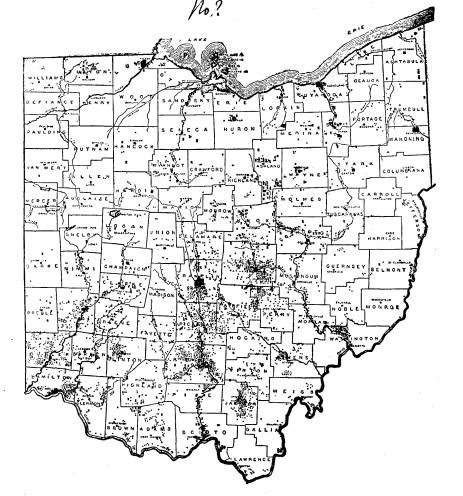
ARCHAEOLOGICAL MAP OF OHIO.
The accompanying map of Ohio, showing
the distribution of
prehistoric Mounds and Enclosures in the
state, is reproduced
on a reduced scale from the
Archaeological Atlas of Ohio. This
map will be of special interest to the
public, as it shows at a
glance the centers of occupation and the
relative distribution of
prehistoric man in the territory
included.
The valleys of the larger rivers-the
Miamis, the Scioto, the
Muskingum, the Hocking, and their
various tributaries, were the
principal localities of a more or less
permanent and numerous
population. The relative sparseness of
earthworks in the north-
western and eastern portions of the
state, is due to topographical
conditions-the former being too swampy
and the latter too rough
and broken to invite extensive primitive
settlement.
The great center of population in the
Miami Valley was
Butler County, with 221 mounds and 24
enclosures recorded. In
the Scioto valley, the central portion,
including the counties of
Ross, Pickaway and Franklin, was most
favored by the aboriginal
Ohio peoples, this section containing
more earthworks than any
other similar area in the state. Ross
county has 370 mounds and
49 enclosures recorded; Pickaway has 173
mounds and 33 en-
closures, and Franklin has 132 mounds and 28 enclosures, mak-
ing a total of 785 earthworks for the
three counties.
Ross county has the distinction of
containing the most highly
specialized types of earthworks, and as
exploration shows, the
territory within that county was the
seat of the highest develop-
ment of aboriginal man in Ohio.
The territory comprised in Licking
county appears to have
been the great center of population of
the Muskingum river and
its tributaries. This perhaps is due in
great measure to the de-
velopment of the important flint
quarries in south-eastern Lick-
ing county.
(409)
