Ohio History Journal
- 1
- 2
- 3
- 4
- 5
- 6
- 7
- 8
- 9
- 10
- 11
- 12
- 13
- 14
- 15
- 16
- 17
- 18
|
EXPLORATION OF THE WRIGHT GROUP OF PRE-HISTORIC EARTHWORKS BY H. C. SHETRONE, CURATOR OF ARCHAEOLOGY The Wright Group of Earth-works is located in Perry Township, IFran-.kli, County, Ohic, one mile north- east of the village of Dubl]in. The three unils com- posing the group --a rectangular and two circular en- |
|
|
|
closures - lie mostly upon the land of Samuel M. Wright, whose name, in rec- ognition of examina- tion privileges and personal assistance accorded by him, is hereby given them. The location of the Wright Group is ideally picturesque, occupying, as it does, the elevated terrace |
|
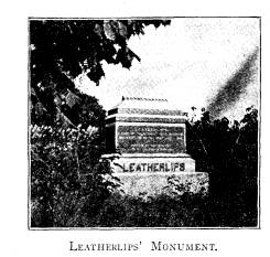
overlooking the Scioto River to the west. Adjoining the group on the east and south is Wright's Run, an attractive stream which, coming down from the north- east, cuts its way through the limestone strata of the district and, tumbling over a picturesque water-fall, passes through a deep gorge and thence into the Scioto River. One mile to the north is the monument to the Wyandot chief Leatherlips. (341) |
|
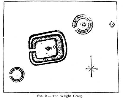
342 Ohio Arch. and Hist. Society Publications The first important notice in archaeological litera- ture of the Wright Group of Earth-works is contained in the Twelfth Annual Report of the Bureau of Ameri- can Ethnology (1890-1891) where, in a paper entitled "Mound Explorations of the Bureau of Ethnology," Doctor Cyrus Thomas furnishes a map of the group, |
|
|
|
(Fig. 2) together with the following descriptive text: ANCIENT WORKS NEAR DUBLIN "The works represented (map) are one mile northeast of Dublin and one-fourth of a mile east of the Scioto River. They are on a nearly level area of the higher lands of the section. Con- trary to what is usual, the soil immediately around them is not nearly so fertile as that a short distance away. "At I is a circular embankment with an inside ditch. The diameter, measuring from the middle line of the embankment on one side, to the middle on the other side, is 120 feet, the wall is |
The Wright Group of Pre-Historic
Earthworks 343
about 10 feet broad and 2 feet
high, and the ditch 15 feet wide
and 2 feet deep, leaving a level
enclosed circular area 80 feet in
diameter. On the east side is a gateway
12 feet wide.
"No. 2 is a rectangular enclosure
with rounded corners. In
measuring it, stakes were set where the
middle line of the embank-
ment would cross if produced. The
distances between these stakes
were as follows: north side, 287 feet;
west side, 212 feet; south
side, 262 feet; east side, 220 feet. The
outer line of the west wall
forms a curve along its entire length;
the other sides are straight.
On the north, east and west sides, the
wall is 25 feet across the
base; on the south side, 35; its height,
quite uniform throughout,
is about 3 feet. It is bordered on the
inside by a ditch, 16 feet
wide on the south side, 20 on the east and
north sides, and 30 on
the west side; depth about 2 feet on the east
side, gradually in-
creasing along the north from 3 to 4
feet, being widest and deep-
est at the south-west corner. Thus more
earth was taken out
along the west line of the ditch and
added to the south side of the
embankment. The rounded outer corners of
the embankment are
20 feet within the points where the
margins of the wall would in-
tersect if carried on straight. The
corners of the inner sides of
the ditch are about ten feet within
their corresponding points.
The passage-way on the eastern side is
15 feet wide. In all
these enclosures the passageway is
simply the natural surface of
the ground between the ends of the ditch
and wall; that is to say,
it is not graded. On the level space
enclosed by the ditch 100 feet
from the top of the east line of the
embankment, is a mound (a)
4 feet high and 35 feet in diameter. On
the top are numerous flat
stones, which it is said had formed
graves enclosing skeletons of
very large size, but nothing could be
learned as to the manner in
which they were buried. Another stone
grave (b), 8 feet in diame-
ter, on the edge or bottom of this mound
on its western side, had
been opened, and so torn up that its mode of
construction could not
be determined. Still west, its edge
extending quite up to the ditch,
is another mound (2) 1 foot high and 24 feet in
diameter. This
had never been disturbed. From the top
of the bank at the north-
east corner of 2 to the nearest
point on top of the embankment
of enclosure 1, is 133 feet; and the
line of the north edge of 2, if
produced, would touch the south edge of
1.
"South-west of 2 is another
circular enclosure (3) similar in
construction to 1; the embankment is 18
feet across and 2 feet
high; the ditch 22 feet wide and 3
feet deep in the deepest part;
the level space enclosed 100 feet in
diameter, making the entire
diameter of enclosure from center to
center of the outer wall
162 feet. The passage-way (opening
directly toward 2) is 22 feet
wide. In the enclosure is a mound (d) 40
feet in diameter and 3
344
Ohio Arch. and Hist. Society Publications
feet high, its center being 60 feet from
the inner edge of the ditch
on the east. The amount of earth in this
mound is hardly suf-
ficient to account for the difference
between the cubic contents of
the excavation and those of the
embankment.
"About 500 feet west of 3 is a
single mound (4) 5 feet high
and 50 feet in diameter".
The general character of the Wright
group, to-
gether with specimens unearthed by the
plow in cultiva-
tion of the land, indicated that these
works were to be
attributed to the Hopewell culture
group of Ohio pre-
historic peoples; and in view of the
fact that the group
is the most northerly located work of
the Hopewell
culture identified up to the present
time, it was felt that
its examination was desirable. Prospects for favor-
able results were not encouraging,
owing to the very
slight elevation of the mounds and the
fact that they
had been cultivated and disturbed; but
the labor in-
volved in examining them was
comparatively small,
and positive identification of the
culture status of the
builders, at least, would be sufficient
recompense for the
effort expended.
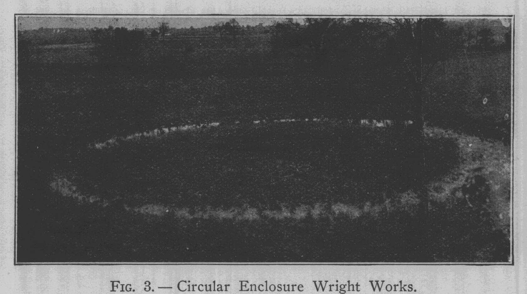
Since the Bureau of Ethnology survey of
the Wright
group was made, the units composing it
have been con-
siderably modified by cultivation,
although they remain,
even at this late date, comparatively
bold. This is par-
ticularly true of the easternmost of
the three enclosures
(1), a circular figure, which is
particularly bold, the
moat of which at the time of
examination contained
throughout its entire circumference
from one foot to
18 inches of water. By using a
vantage-point furnished
by a nearby tree, a photograph
compassing the entire
enclosure, with its water-filled moat,
was secured. (Fig.
|
The Wright Group of Pre-Historic Earthworks 345 3). This enclosure contained no mound, and an exami- nation of its interior disclosed no burials or other re- mains. |
|
|
|
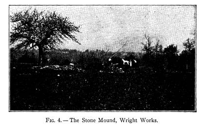
The mound within the central figure--the square enclosure represented as No. 2, was found to have been considerably modified in size and shape through the re- moval of stone from its top and sides, and through continued encroachment of cultivation around its mar- gin. in which process the stones extending outward from the circumference had been dislodged and removed or thrown upon the mound. Its approximate dimensions, as a result, were 28 feet east and west and 20 feet north and south, with a maximum height, toward the east end, of 34 inches. The mound, examination of which is shown in Fig. 4, was entirely removed--a difficult task, in view of the great quantity of flat limestone slabs composing the structure and the growth of shrubbery and small trees which practically covered it, their roots penetrating in every direction and binding the whole closely together. |
|
346 Ohio Arch. and Hist. Society Publications The examination revealed these results: Upon a fairly level but not greatly used floor or base, there had been erected a structure composed of clean clayey loam, 15 inches in depth at the center. Upon the floor or base, a thin covering of charred matter appeared, but no post- molds indicating a pre-structure of timbers, and no burials or other remains, were found. However, placed directly upon the top of the low earthen mound there had been deposited a total of 11 burials, of a very unusual |
|
|
|
nature. Instead of the usual cremated burials of the culture, or the alternate ordinary uncremated burials, the bones of the skeletons had been broken into frag- ments, and the little heaps resulting, in every way re- sembling the cremated burial, but unburned, were de- posited simply and without accompanying artifacts, upon the surface of the soil. Covering these burials, which were placed at random throughout the structure, were slabs of limestone, often measuring three feet in length. |
The Wright Group of Pre-Historic
Earthworks 347
This covering of limestone slabs was
not confined to the
burials, but formed an arch, several
layers deep, over the
entire mound. Upon and above this stone
covering,
which in a way suggested the ceremonial
sand or gravel
strata characteristic of the more
central mounds of the
culture, had been heaped earth from the
surrounding
surface, the amount or depth of which
was indetermi-
nate, owing to the disturbance which
the mound had
suffered.
It was found that at some early date,
beyond the
recollection of the owner or old
residents of the district,
a shaft had been sunk at the center of
the mound. This
covered, at the base, a space roughly 4
feet in diameter,
and had reached well below the base
line. It served a
useful purpose, in that it enabled the
present survey to
determine, without doubt, that the
remainder of the
structure had not been disturbed to any
appreciable
depth.
With the idea in mind that burials
might possibly
be found outside the mound, within the
level space of
the enclosure, numerous tests were made
by trenching.
A single burial, unique perhaps in
character, was found
at a distance of 30 feet south-west of
the base of the
mound.
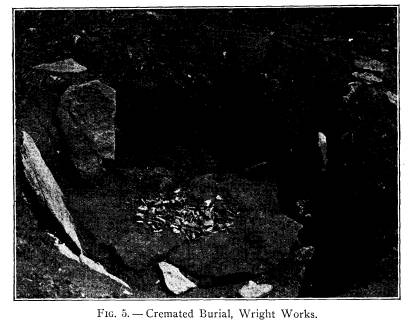
This burial, shown by the accompanying
photograph,
(Fig. 5) lay one foot below the present
surface, and
consisted of a basin-like receptacle
formed by laying
down slabs of limestone within the
shallow excavation,
the placing of the human remains
therein, and the cover-
ing over of these with other thin slabs
of limestone. The
burial was a cremated one, typical in
every respect in
the amount and character of the
remains. It was un-
accompanied by artifacts.
|
348 Ohio Arch. and Hist. Society Publications Unit No. 3, being the circular enclosure to the west- ward, contained a burial mound which, according to the above-mentioned survey was, at the time, 3 feet high. Since that survey was made, the land on which the en- closure and mound lie has been plowed and cultivated. In breaking this land, for the first time, in 1914, Mr. Wright, the owner, came upon four graves. He was able to point out the location of these, and to describe them and their contents. Their location was verified in the examination of the structure. |
|
|
|
The entire site of this mound was carefully exca- vated, the result showing that the Bureau of Ethnology survey had erred in the height of the mound, rather that they did not foresee that the greater part of the apparent elevation was a natural one; in fact, the arti- |
The Wright Group of Pre-Historic
Earthworks 349
ficial elevation, or mound proper, did
not exceed 12
inches at its highest point. Since this
work has been
cultivated but little since the time of
the Bureau survey,
it has been but slightly modified in
form. As a result,
the cultivation of the site had
disturbed all graves, only
the bottoms of which remained for the
present survey,
and to enable the exact identification
of the disturbed
burials.
Of the four burials contained in this
mound, two
were cremated, and two buried in a
natural way, un-
cremated. Near the center of the mound,
within a
stone grave, had been placed a cremated
burial, from
which Mr. Wright took a large ocean
shell container and
half a dozen finely made flint flake
knives. Our exami-
nation disclosed the disturbed grave,
and two additional
flake knives. A second cremated burial
lay about 4
feet to the south-east of the center,
was covered by stone
slabs, but contained no artifacts. Just
south of center
was found an uncremated burial, the
skeleton well pre-
served, with which, placed near the
head, was a pair of
spool-shaped copper ear-ornaments. The
skull of this
burial was sent to the museum at the
time of finding by
Mr. John Wing of Dublin.
The fourth burial, uncremated, lay to
the north-
west of center. With this was found a
plain platform
pipe, of the usual pattern, and a slate
gorget. In ad-
dition to these burials, the present
survey noted the re-
mains of a fifth, just north of center.
This was un-
cremated, with the covering of stone
slabs, below, at
least, and showed merely the vestiges
of a flexed skele-
ton, mostly dislodged by the plow. A
few fragments of
mica, the incisor tooth of a beaver,
and a few flake
350
Ohio Arch. and Hist. Society Publications
flint knives were scattered through the
disturbed earth
of the mound.
The specimens taken from these graves
by Mr.
Wright are in the collection of Mr. F.
P. Hills, of Dela-
ware, Ohio, with the exception of the
flaked knives, of
variegated Flint Ridge material, which
were presented
to the Museum by Mr. Wright.
THE KRUMM MOUND
With the permission of Mr. C. S. Krumm,
upon
whose land it is located, the
westernmost mound shown
on the map of the group was examined.
Owing to the
fact that it lies at some distance from
the earthworks
proper, it had remained undetermined
whether or not
this mound actually pertained to the
Wright group. The
structure was slightly more than three
feet in height,
with an indeterminate lateral extent,
owing to long-con-
tinued cultivation. It was found to be
composed of the
clay and loam of the surrounding
surface, was without
definite features as to its construction,
and contained a
total of six carelessly deposited
partial skeletons, or re-
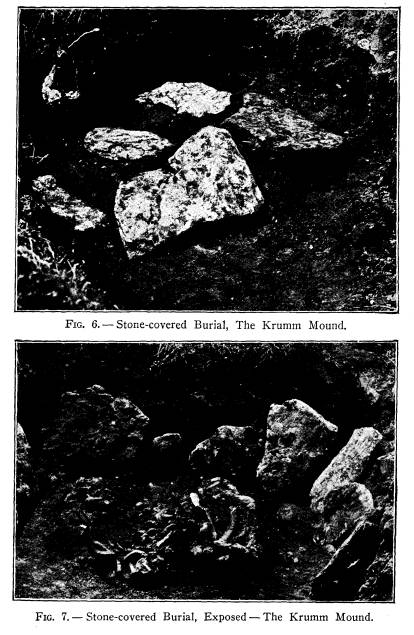
burials. The only burial of interest is
that shown in
the accompanying cuts, in which (Fig.
6) is shown the
deposit before lifting the covering of
stone slabs and
(Fig. 7) the promiscuous lot of human
skeletal remains
beneath them. With these remains,
comprising ap-
parently parts of three or more
skeletons, was a stemmed
flint spear-point, three inches in
length, made from
variegated Flint Ridge material.
Although material evidences within the
Krumm
mound were rather scant, they are
sufficient to demon-
strate clearly that this mound was not
constructed by
the builders of the Wright group, but
that it probably
|
The Wright Group of Pre-Historic Earthworks 351 |
|
|
|
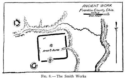
352 Ohio Arch. and Hist. Society Publications had its origin with the peoples whose burials are found so freely within the gravel deposits of this region of the Scioto Valley. CONCLUSION Examination of the Wright Group proves that these works belong to the Hopewell culture group; inciden- tally, they are perhaps the most northerly example of their kind so far identified. While definitely Hopewell in their characteristics, the evidence adduced by explora- tion points to an outlying colony or band which had ranged farther to the north of the principal areas of occupation. The nearest earthwork of the same cul- ture is the Smith Group, one mile west of Worthington, on the west bank of the Olentangy River, some four miles to the south-east. This group, shown as Fig 8, |
|
|
|
is quite pretentious, the larger of the two mounds being upwards of 30 feet in height. It is readily conceivable that the Wright works were constructed and occupied |
The Wright Group of Pre-Historic
Earthworks 353
by a band from the Smith Group, which
in itself is
doubtless an outpost of the larger
settlements to the
south, or of the great works at Newark,
40 miles to the
eastward and only slightly to the
southward. The in-
termediate form of burial as practiced
in the stone
mound of the Wright group, where the
breaking into
fragments of the skeletal remains seems
to have been
substituted for cremation; and the
depositing of a cre-
mated burial in a stone grave, outside
the mound proper,
are interesting details of the
exploration of this group.
THE McGUERER BURIAL SITE
On the farm of Mr. Chauncey McGuerer,
one-half
mile north of Dublin, on the east side
of the Scioto River,
and at about the same distance south
from the Wright
Group of Earthworks, there was opened,
in 1921, a
gravel pit from which large quantities
of gravel for
county road construction have been
taken. The gravel
deposit corresponds to the edge of the
terrace overlook-
ing the bottom lands of the Scioto
which, at this point,
are very narrow. It was not until the
ensuing year,
just preceding the examination of the
Wright Group,
that the Museum was apprised, through
Dr. H. O. Whit-
taker, of Dublin, of the fact that
steam shovels employed
in removing gravel had unearthed many
human skele-
tons. At this time, however, the
industry was at the
point of being discontinued, and only a
limited portion
of the burial site remained for
examination.
Assisted by Dr. Whittaker and a
workman, the
writer spent three days in a cursory
examination of
those portions of the site available,
with the results
here recorded.
|
354 Ohio Arch. and Hist. Society Publications At the east side of the cut, where the steam shovel had discontinued operations, there appeared to view a discoloration of the gravel which, upon examination, proved to be the margin of a burial pit. This pit, upon being cleared out, was found to be approximately seven feet across at the top, and to extend to a depth of six feet. The width at the bottom of the pit was approxi- mately four feet, although the caving in of the gravel made it difficult to determine the exact size and shape of the excavation. Within this pit there had been dumped a surprising number of human bones, some of which had been tied in bundles, while others apparently were thrown in one by one. The long bones of the arms and legs predominated in numbers, while many vertebrae and other small bones seemed to be absent. From the total deposit, Doctor Whittaker identified 31 distinct individuals, all adults. Over the mass of bones, before filling in the pit with earth, there had been dumped a |
|
|
|
The Wright Group of Pre-Historic Earthworks 355 large quantity of red ochre, the result being that
most of the bones were more or less coated with the
pigment. The only artificial objects found with the deposit
was a pair of cut perforated jaws of the wild-cat. |
|
|
|
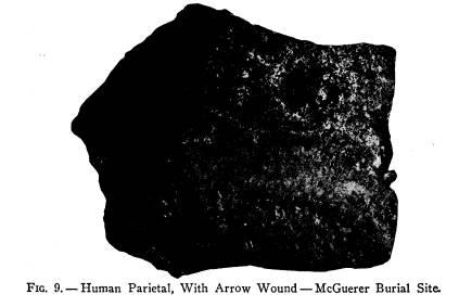
An interesting feature of the remarkable deposit of human skeletal remains was the finding of two
bones bearing the marks of wounds from flint arrow-points. One of these is the right parietal bone of the human |
|
|
356
Ohio Arch. and Hist. Society Publications
skull, pierced by a pointed weapon,
presumably a flint
arrow-point. In Fig. 9 is shown the
outer aspect of the
bone with the diamond-shaped
perforation, while Fig.
10 shows the inner side, with the wall
of the skull forced
inward and into the brain to a depth
more than equal to
the thickness of the skull. That the
wound was not im-
mediately fatal is apparent from the
fact that the per-
foration shows new bone tissue thrown
out in the process
of mending or healing. The second
specimen, shown as
Fig. 11, is a human dorsal vertebra,
into the body of
which there is embedded a flint
arrow-point. The ar-
row-point is of pink flint, notched
type, measures five-
eighths of an inch in width and
apparently is between
one and one-fourth and one and one-half
inches in
length. Over the vertebra and its
embedded arrow-
point and almost completely covering
them, is the coat-
ing of red ochre thrown into the pit
after the bones
were deposited. Unlike the arrow wound
in the parietal
bone, there is no evidence of healing
in this specimen,
and from the fact that the projectile
point must have
passed through the chest from a
direction several de-
grees to the left of center, thus piercing
the vital organs
before burying its point in the
anterior or body portion
of the vertebra, it is evident that
death must have been
practically instantaneous.
A second pit, the margin of which
appeared in the
edge of the cut, as in the above
deposit, was found to
be seven feet in depth. It contained,
at the bottom, two
adult skulls. A short distance eastward
from the mar-
gin of the cut there was uncovered the
skeleton of a
youth, buried about 15 inches beneath
the surface. The
badly decayed skeleton was accompanied
by a set (upper
The Wright Group of Pre-Historic
Earthworks 357
and lower) of cut and polished jaws of
the wolf. The
work of examination was carried on by
taking advantage
of the vertical wall, some ten feet
high, resulting from
steam shovel operations. This wall was
repeatedly
caved off, thus disclosing the pits and
burials. A third
pit, brought to light in this manner,
contained a deposit
of bundled bones, principally the long
bones of the arms
and legs, with which were placed a
string of large and
small shell disk beads.
The only skeleton found buried intact
was that of a
very old individual, the jaws almost
toothless and the
tibia very much bowed. The burial,
placed at a depth
of three feet, lay on the right side,
falling forward onto
the face and stomach, and had the legs
tightly flexed
to the body. A rude implement, of the
roller-pestle type,
lay at the head of the grave.
Several other pits, from three feet to
six feet deep
were worked out, and found to contain
neither burials
nor implements. The purpose of these
pits, which ap-
pear to have been very numerous within
the area from
which the gravel was removed, is not
clear. The greater
number of them contained merely hard
dark earth, with
occasional fragments of pottery, bone
and flint, filling
the funnel-like pits dug into the clear
gravel deposit.
Since the portion of this rather
extensive burial
site available for examination was so
limited, no very
broad nor definite conclusions can be
drawn therefrom.
It can be said, however, that the
occupants of the site
were the same peoples whose villages
and camp sites
are found rather freely along the
central course of the
Scioto and whose burials are to be found
in many of the
358
Ohio Arch. and Hist. Society Publications
gravel terraces bordering the valley.
From the rather
scant evidence, it appears that the
small mound half a
mile to the north, on the Krumm land,
may be attributed
to the same tribes.
|
EXPLORATION OF THE WRIGHT GROUP OF PRE-HISTORIC EARTHWORKS BY H. C. SHETRONE, CURATOR OF ARCHAEOLOGY The Wright Group of Earth-works is located in Perry Township, IFran-.kli, County, Ohic, one mile north- east of the village of Dubl]in. The three unils com- posing the group --a rectangular and two circular en- |
|
|
|
closures - lie mostly upon the land of Samuel M. Wright, whose name, in rec- ognition of examina- tion privileges and personal assistance accorded by him, is hereby given them. The location of the Wright Group is ideally picturesque, occupying, as it does, the elevated terrace |
|
overlooking the Scioto River to the west. Adjoining the group on the east and south is Wright's Run, an attractive stream which, coming down from the north- east, cuts its way through the limestone strata of the district and, tumbling over a picturesque water-fall, passes through a deep gorge and thence into the Scioto River. One mile to the north is the monument to the Wyandot chief Leatherlips. (341) |
(614) 297-2300
