Ohio History Journal
- 1
- 2
- 3
- 4
- 5
- 6
- 7
- 8
- 9
- 10
- 11
- 12
- 13
- 14
- 15
EXPLORATION OF THE GINTHER MOUND
H. C. SHETRONE, CURATOR OF ARCHAEOLOGY.
The type of prehistoric tumuli known
variously as
Temple mounds, Platform mounds,
Truncated mounds
and Flat-topped mounds has furnished
substance for
much speculation in the archaeological
literature of
Ohio.
The early attitude of writers on the subject
may be summarized in the words of
Squier and Davis,
whose opinion is expressed as follows:
"So far as ascertained, they cover
no remains, and seem
obviously designed as the sites of
temples or of other structures
which have passed away, or as 'high
places' for the performance
of certain ceremonies."
Fowke, however, writing at a much later
date, is
not content with this convenient
disposition of the mat-
ter, and states that
"As none of them have been explored
except in a very in-
adequate and perfunctory manner, the
assertion that 'they cover
no remains' is not warranted by our
present knowledge."
Only a few examples of the type of
mound under
consideration occur in Ohio, the most
notable being
those in connection with the great
enclosures at Mari-
etta, with minor ones at Newark and
Portsmouth; a
low but extensive one within the Cedar
Bank works,
north of Chillicothe; and, in close
proximity to the last-
named, the rather striking Ginther
Mound--the sub-
ject of this report.
(154)
|
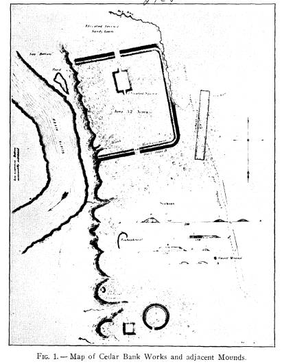
Exploration of the Ginther Mound 155 The accompanying map of the Cedar Blank works and vicinity, (Fig.1) after Squier and Davis, shows |
|
|
|
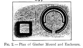
FIG. 1 -- Map of Cedar Bank Works and adjacent Mounds. the location of the Ginther mound and circular en- closure, while their smaller drawing (Fig. 2) depicts |
|
156 Ohio Arch. and Hist. Society Publications the Ginther works in more detail. Their description of the same is as follows: "About one-third of a mile south of the principal work (Cedar Bank) is a truncated pyramid, and a small circle; the former is 120 feet square at the base, and nine feet in height; the latter is 250 feet in diameter, and has an entrance from the south, 30 feet wide. The sides of the pyramidal structure correspond to the |
|
|
|
FIG. 2. -- Plan of Ginther Mound and Enclosure. cardinal points. The circle has a ditch interior to the embank- ment; and has also a broad embankment of about the same height with the outer wall, interior to the ditch, upon the side opposite the entrance * * * The 'elevated square' has been excavated, but was found to contain no remains." Since the Ginther works, as is true of most of Ohio's prehistoric tumuli, have suffered modifications in form and size through cultivation, the drawings and measure- ments of the early explorers are here set down. While the mound itself was found to equal the dimensions given therein, the circle has almost disappeared beneath the plow, and at the present time is just barely traceable. Although Squier and Davis state explicitly that the Ginther mound had been excavated and found to con- tain nothing, the Museum authorities felt that, in view of the fact that it is practically the only mound of its type remaining available for examination, and since there is a recognized growing demand for information |
|
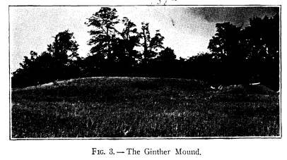
Exploration of the Ginther Mound 157 regarding their use and purpose, it should be explored. This sentiment was strengthened by the significant lo- cation of the tumulus, which lies midway between, and in close proximity to, the Cedar Bank works on the north and the Hopeton works to the south, while just across the Scioto river to the west is the important Mound City group. Since the Cedar Bank and the Hopeton works are practically devoid of mounds, it was felt that the Ginther mound night prove to bear a very close relationship to either or both of them. With the kind permission of Mrs. Mary Ginther, |
|
|
|
owner of the land upon which the works are located, and with the cooperation and assistance of Mr. M. D. Vaughan, manager of the estate, examination of the Ginther mound (Fig. 3) was begun on July 8 and com- pleted on August 15, 1922. The final calculations of Mr. John H. Jefferson, surveyor for the project, showed the structure to be ten feet in maximum height, while the flattened portion, with a diameter of 70 feet, aver- aged slightly less than nine feet high. The floor ex- |
158 Ohio Arch. and Hist. Society Publications
tent was approximately 100 feet east
and west and 125
feet north and south. There was no
evidence to indi-
cate that the mound ever had been
geometrically rect-
angular in form, as shown in Squier and
Davis' drawing,
although this feature, particularly the
outward angular
aspect of the tumulus, may have been
obliterated by
cultivation and erosion.
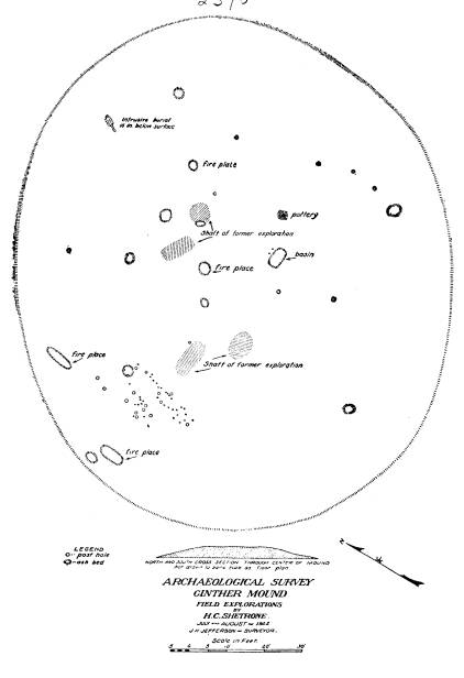
The accompanying map of the floor,
(Fig. 4) made
by Mr. Jefferson for our survey, tells
the story of the
Ginther mound. The explanation should
be noted, how-
ever, that with a single exception the
ash-beds, fire-
places and other indicia shown on this
plan in reality
do not pertain to the mound proper, but
were found be-
neath the floor where they had been
made and used pre-
vious to the erection of the mound. In
a word, despite
the fact that the Ginther mound was
shown to be of
the Hopewell culture and that it
contained a typical and
highly specialized floor, there had not
been placed within
it a single burial or deposit, nor did
it contain a single
basin of the so-called crematory type
-- an almost in-
separable adjunct of the Hopewell
mounds.
The exception to this perhaps
unprecedented barren-
ness of the floor of such mounds was a
singular depres-
sion lying just east of center. This
was rectangular in
form, measuring three feet by five
feet, and extended
almost east and west. The floor around
this basin or
depression was heavily covered with
coarse sand and
fine gravel, of a reddish-yellow color.
The pit itself
which, when cleared out, was found to
be 16 inches in
depth, contained, first, a stratum of
the same sand as
that covering the floor, three inches
thick; beneath this,
a layer of dark organic matter,
interspersed with numer-
ous animal and bird bones, broken
pottery-ware, bits
|
Exploration of the Ginther Mound 159 |
|
|
160
Ohio Arch. and Hist. Society Publications
of mica, flint chips and mussel shells;
below this was a
layer, four inches thick, of clayey
loam, intermixed with
which were a few animal bones; while at
the bottom
a stratum four inches in thickness was
composed of
carbonaceous material, containing the
same sort of
debris as the above strata. Near this pit were two
small post-holes.
What may be considered a second
deviation from the
uniform dearth of deposits or structures
on the floor of
this mound was the occurrence,
northeast of the basin,
of a post-hole, around which had been
laid, covering
a rectangular space 11 by 16 inches in
extent, carefully
fitted fragments of pottery-ware. These, pavement-
like in their disposition, were shreds
from utility ware,
cord-marked, ranging in size from small
fragments to
pieces three or four inches across.
The very striking and finely
constructed floor of
this mound extended uniformly to the
very edge of
the super-incumbent earthen structure,
and comprised
approximately 10,000 square feet of
surface. The
covering of sand often reached a depth
of more than
one inch, particularly toward the south
side. A gradual
and apparently intentional slope from
the north termi-
nated in a gutter along the southern
circumference, for
drainage. A few post-molds occurred
around the outer
edge of the floor, but these were not
in sufficient num-
bers to indicate any extensive attempt
at roofing. Upon
the floor, particularly toward the
south and west, great
numbers of chips and flakes from the
translucent and
variegated Flint Ridge chalcedony and
the gray or drab
nodular flint were scattered. Among
these were oc-
casional finished projectile points and
flake knives.
Of the several ash-beds and fire-places
found be-
Exploration of the Ginther Mound 161
neath the floor, the positions of which
are indicated on
the map, it only need be said that they
were entirely
similar to that found upon the floor
described above,
in so far as contents are concerned,
and that in form
they were similar but much less
specialized and less
carefully constructed.
The one development of particular
interest in the
sub-floor examination was the finding
of what appears
to have been a food offering, or at
least a cache deposit
of food. A pit, three feet across, had been dug to a
depth of 18 inches below the floor
line, and on the flat
bottom of this had been deposited a
half-bushel of
hickory-nuts, of the common shell-bark
variety. Around
the edges of this deposit were placed,
with apparent
order, a number of mussel-shells,
presumably to serve
as spoons or ladles. On top of the
deposit, at its cen-
ter, was the remains of a burned clay
vessel, of the
utility type, containing a number of
animal bones, among
which were identified the vertebrae,
shoulder-blade and
split leg-bones of the deer. Around the
pit containing
the deposit had been set small posts
and stakes, enclos-
ure-like.
The earth comprising the mound was that
gathered
promiscuously from the adjacent surface and from
ravines and washes. The individual
loads or basketfuls
often were clearly distinguishable by
their colors. A
single intrusive burial -- that of a
young adult -- was
found, badly decomposed, one foot below
the surface
on the northern slope of the mound.
Four old shafts, sunk to either side of
center in a
line north and south were disclosed by
our survey. They
were each about five feet across at the
point of con-
tact with the floor. Aside from Squier
and Davis' state-
162 Ohio Arch. and Hist.
Society Publications
ment, as before noted, no record of
such examination,
nor by whom conducted, has been found.
The accompanying map of the Cedar Bank
works
shows a small mound occupying the point
of land just
to the north-west of the Ginther
works. This is on
land now owned by the Shilder brothers,
of Chillicothe,
who generously permitted its
examination. The struc-
ture was found to be two feet high at
the center, with
an indeterminate diameter, as a result
of cultivation and
from the fact that no floor line
existed. Occupying the
central portion of the elevation there
was found a mass
of burned clay, reaching from the
supposed base-line
to within a few inches of the top, and
covering a space
nine feet in diameter. At the bottom
center of this mass
was found a partial human skeleton, the
skull, femuri
and a few small bones only being
present. It was noted
that the earth beneath the skeleton was
disturbed, and
excavation disclosed a circular pit,
four and one-half
feet in diameter, reaching to a depth
of three feet be-
neath the base line. On the flat bottom
of this pit was
found a layer, six inches in depth,
composed of inter-
mixed carbonaceous matter and small
plates and frag-
ments of mica. A few of the mica plates
were as much
as six inches across, but none was cut
into form. Three
flake knives, of drab nodular flint,
were found in the
layer. No other part of the mound
disclosed remains.
In the same field and adjoining the
Shilder mound
on the north-east, are a number of
tipi-sites and fire-
places. The presence of these is
readily noted when
the ground is freshly plowed, or in the
greater luxuri-
ance of the grain under cultivation.
They are charac-
Exploration of the Ginther Mound 163
terized by an abundance of burned
stone, flint-chips,
broken pottery-ware and fragments of
mica. In two of
these, beneath the plow-lines, were
found flake knives
of the drab flint, exactly similar to
those taken from the
Shilder and the Ginther mounds. It is everywhere
evident, from the remains of tipi-sites
and other indi-
cations, that the entire face of the
terrace, from the
Cedar Bank group southward past the Ginther
works to
the Hopeton group, was the place of
habitation of the
peoples who constructed and utilized
these several works.
That the Ginther mound, the Shilder
mound and
the accompanying tipi-sites pertain to
the great Hope-
well culture group of prehistoric
peoples will be evident
to the student of Ohio archaeology, if
not, indeed, to
the casual reader. Whether future
explorations will
continue to bear out Squier and Davis'
seemingly un-
warranted surmise that the flat-topped
mounds contain
no remains, remains to be seen. We can,
even at this
late date, speak authoritatively only
of a single one --
the Ginther mound. In this instance we
know that no
human remains were enclosed, and if one
were inclined
to speculation it would not be
difficult to surmise that
the impressive tumulus was erected to
mark the spot
where some event or occurrence of great
moment and
significance to its builders transpired
-- rather than as
as monument to the dead.
THE MIESSE MOUND.
The Miesse Mound is located in Green
township,
Ross county, Ohio, on the land of Dr.
Charles Miesse,
of Chillicothe. It lies on the brow of
the second ter-
race of the Scioto river valley, about
one mile north-east
164
Ohio Arch. and Hist. Society Publications
from the Ginther mound, and about
one-third of a mile
east of the Cedar Bank works. Upon
completion of
the examination of the Ginther mound,
and at the re-
quest of Mr. Albert C. Spetnagel, who
had secured ex-
ploration privileges, the force of
laborers was employed
for one day, August 10, 1922, in its
examination.
The structure was found to be 25 feet
in diameter
and about two feet in height. It was
composed of the
yellow clay of the region and was
entirely homogenous
throughout. It was found to contain five distinct
burials -- four of them being simple
uncremated skele-
tons, placed singly, while the fifth
consisted of an un-
cremated skeleton accompanied by the
cremated re-
mains of two or more individuals.
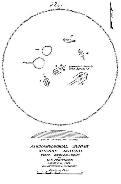
One of the uncremated skeletons (number
1 in the
accompanying floor plan) lay within the
south-west
quarter of the mound, on the original
surface. It was
that of an adult male, about five feet
and seven inches
in height, which lay extended on the
back with head
to the southeast. Several bones of the
skeleton were
missing, the burial apparently being a
re-burial. It
was unaccompanied by artifacts, but the
right femur
was penetrated by a chipped flint
arrow-point, of black
material, two inches in length. The
projectile had
pierced the heavy bone, to and through
the interior
canal, reaching to the opposite wall.
The force with
which the weapon struck the angular
edge of the bone
had resulted in shattering the extreme
tip or point, and
the fragments apparently had worked
their way out of
the wound, in the resulting
suppurition. That the wound
was not a fatal one is shown by the
fact that the perfora-
tion had healed, considerable new bone
tissue having
been thrown out around the embedded
point. That the
|
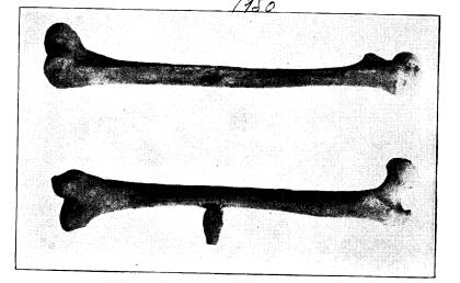
Exploration of the Ginther Mould 165 arrow-point itself had remained in place in the shaft of the femur is explained, doubtless, by the fact that it was embedded in the heavy muscles of the leg, and in the absence of efficient surgical skill, was suffered to re- main within the wound. The cut (Fig. 1) illustrates |
|
|
|
the femur bone with the arrow-point in place, as found; and the wound, with the arrow removed. A second skeleton (number 2) almost complete but badly decomposed, lay in the south-east quarter of the mound. It was disposed similarly to the above and was without distinctive features. Two partial skeletons (numbers 3 and 4) lay within the north-east quarter of the mound. A rude refuse pit and a fire-place occupied the north-west section, as shown on the plan. The feature of the Miesse mound was the central complex burial, shown as number 5. This occupied a grave, dug at about the center of the structure to a |
|
166 Ohio Arch. and Hist. Society Publications depth of 15 inches below the original surface and meas- uring six feet in length and two feet and four inches in |
|
|
|
width. In it had been placed an adult human skeleton, uncremated, with head to the south-west. On the chest |
|
Exploration of the Ginther Mound 167 |
|
|
168 Ohio
Arch. and Hist. Society Publications
of the skeleton lay the base portion of
a spear-point
of translucent flint, while at the
knees were a truncated
cone of white limestone, a turtle-shell
container, an ar-
row-point of black flint, the incisor
of a beaver, and the
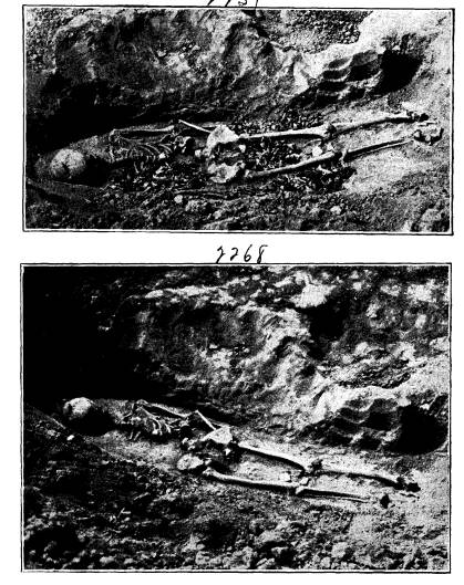
tip of a deer antler. Beneath and around this skeleton,
extending from the head to the knees,
were disposed the
cremated remains of two, and probably
three individuals.
The cut shown as Figure 2 shows the
burial as uncov-
ered, while Figure 3 illustrates the
uncremated skeleton
after removal of the cremated remains.
The finding of a burial in which an
uncremated
skeleton was accompanied by cremated
remains, as in
this example, is interesting and unusual,
if not indeed
unique. The arrow-pierced femur is one of the best
illustrations yet found in the Ohio
mounds of the pene-
trating power of the primitive flint
implement.
EXPLORATION OF THE GINTHER MOUND
H. C. SHETRONE, CURATOR OF ARCHAEOLOGY.
The type of prehistoric tumuli known
variously as
Temple mounds, Platform mounds,
Truncated mounds
and Flat-topped mounds has furnished
substance for
much speculation in the archaeological
literature of
Ohio.
The early attitude of writers on the subject
may be summarized in the words of
Squier and Davis,
whose opinion is expressed as follows:
"So far as ascertained, they cover
no remains, and seem
obviously designed as the sites of
temples or of other structures
which have passed away, or as 'high
places' for the performance
of certain ceremonies."
Fowke, however, writing at a much later
date, is
not content with this convenient
disposition of the mat-
ter, and states that
"As none of them have been explored
except in a very in-
adequate and perfunctory manner, the
assertion that 'they cover
no remains' is not warranted by our
present knowledge."
Only a few examples of the type of
mound under
consideration occur in Ohio, the most
notable being
those in connection with the great
enclosures at Mari-
etta, with minor ones at Newark and
Portsmouth; a
low but extensive one within the Cedar
Bank works,
north of Chillicothe; and, in close
proximity to the last-
named, the rather striking Ginther
Mound--the sub-
ject of this report.
(154)
(614) 297-2300
