Ohio History Journal
THE "DIVIDE."
The Water-Shed of Richland County,
Ohio.
BY A. J. BAUGHMAN.
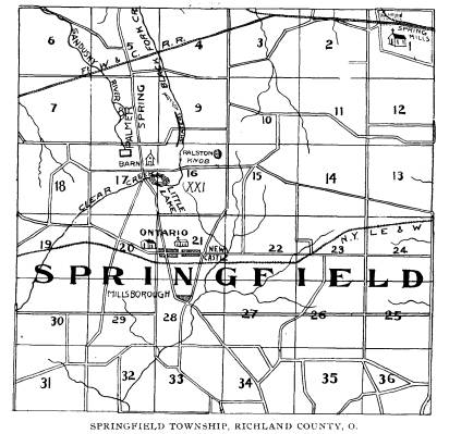
The far-famed barn, from the eaves of
which the rain-falls
flow from one side into Lake Erie and
from the other to the
Ohio river is situate near "Five
Corners" in Springfield township,
seven miles west of Mansfield, Richland
County, on the West
Fourth street, or Leesville road.
That this barn is not a myth but an
actual reality can be veri-
fied by a visit to the locality. The
farm upon which the building
stands is owned by C. Craig, a cousin of
Dr. J. H. Craig, of
Mansfield.
While this barn is not on the highest
point of land in the
state, it is upon the actual
"divide," and has an elevation of 832
feet above the lake, 965 feet above the
Ohio river, and 1,265 feet
above the sea. A mile east of the Craig
barn is the Ralston knob,
which reaches a higher elevation, but is
not a "divide," for the
surface waters from its several sides
all find their way into the
Mohican.
Contrary to the general opinion, the
roof of this barn does not
face north and south, but to the east
and west, being situate upon
a spur extending a short distance to the
north from the dividing
ridge proper, which traverses Ohio from
the northeast to the
southwest. From the east line of Ohio in
Ashtabula county, the
crest of the water-shed extends in a
tortuous course through
Trumbull, Geauga, Portage, Summit,
Medina, Wayne, Ashland,
Richland, Crawford, Marion and Hardin
counties and from the
latter it throws off a lofty spur into
Logan county, but the main
line continues from Hardin southwest
between Auglaize and
Shelby, through the corner of Mercer and
the northern part of
Darke to the Indiana line, at elevations
ranging from 400 to 900
feet. The gravel knobs - like the one at
Ralston's, are frequently
found along the divide, and are
interesting subjects in the study
of surface geology.
(160)