Ohio History Journal
- 1
- 2
- 3
- 4
- 5
- 6
- 7
- 8
- 9
- 10
- 11
- 12
- 13
- 14
- 15
- 16
|
THE BLACK HAND.
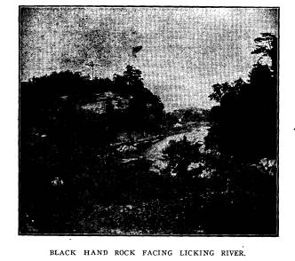
JOHN D. II. M KINLEY. The Licking river, the Pataskala of the Indians, as it draws near the eastern boundary of Licking county, Ohio, flows in a winding course for a distance of about two miles through a nar- row and picturesque sandstone gorge, known as the Licking Narrows. High hills border upon both banks, their rocky sides |
|
|
|
exposed in many places to a height of fifty to sixty feet, almost continuously on the north bank, and often rising out of the bed of the stream. Just at the eastern end of the Narrows the river flows in its narrowest channel between twin cliffs. That on the south side has been quarried and boated way, so that it no longer shows the extent of the face originally presented to the stream, though enough remains to give an idea of its former height. That on the north side is isolated, with a surface area on its (444) |
The Black Hand. 445
summit of perhaps the third of an acre
covered principally with
pines, laurel and moss. It is circular
in form except on the
south, where it presents to the river a
face about two hundred
feet in length, rises to a height of
fifty feet, and, arching from
a point some distance above its base,
overhangs the stream about
fifteen feet. This is the Black Hand
rock.
At some period in the distant past these
cliffs, united,
formed an impassable barrier to the
stream, for-an old channel
turns abruptly to the north on the west
side of the Black Hand
rock, makes a circuit, and returning
cuts straight across the
present channel at a distance from its
point of departure of only
the width of the rock itself, and bears
away southward in a
narrow, rock-bound course. This old
channel resembles in shape
a horseshoe, bounded continuously on its
outer side by a rocky
ledge, and holding between its points
the Black Hand rock.
This outer rim of rock reaches the
present channel of the river
with a face of about two hundred and
fifty feet, with a height
slightly greater than that of the Black
Hand rock, and forms the
final barrier to the entrance of the
stream in its present course to
the valley beyond. It has been named by
present-day visitors,
the Red Rock. At some more recent date
the stream must have
been diverted from this old channel into
its present course.
The peculiarity of formation adds
greatly to the interest of the
place, and from the standpoint of the
geologist has been convinc-
ingly treated by Professor Wm. M. Tight,
president of the Uni-
versity of New Mexico, in Bulletins of
the Scientific Laboratory
of Dennison University.
When the Central Ohio railroad was
built, it followed the
natural grade along the south bank of
the Licking. When the
twin cliff opposite the Black Hand rock
was reached, a cut
was made through it, so that the
traveler by the Baltimore &
Ohio is hindered by this from a distinct
view of the Black Hand
rock. An electric line from Newark to
Zanesville now passes
along the north bank of the river within
a few feet back of the
Black Hand rock, and tunnels through the
Red Rock. By such
a pleasant and convenient mode of access
it is probable that the
Black Hand will be visited more
frequently by pleasure-seekers
than heretofore.
|
446 Ohio Arch. and Hist. Society Publications.
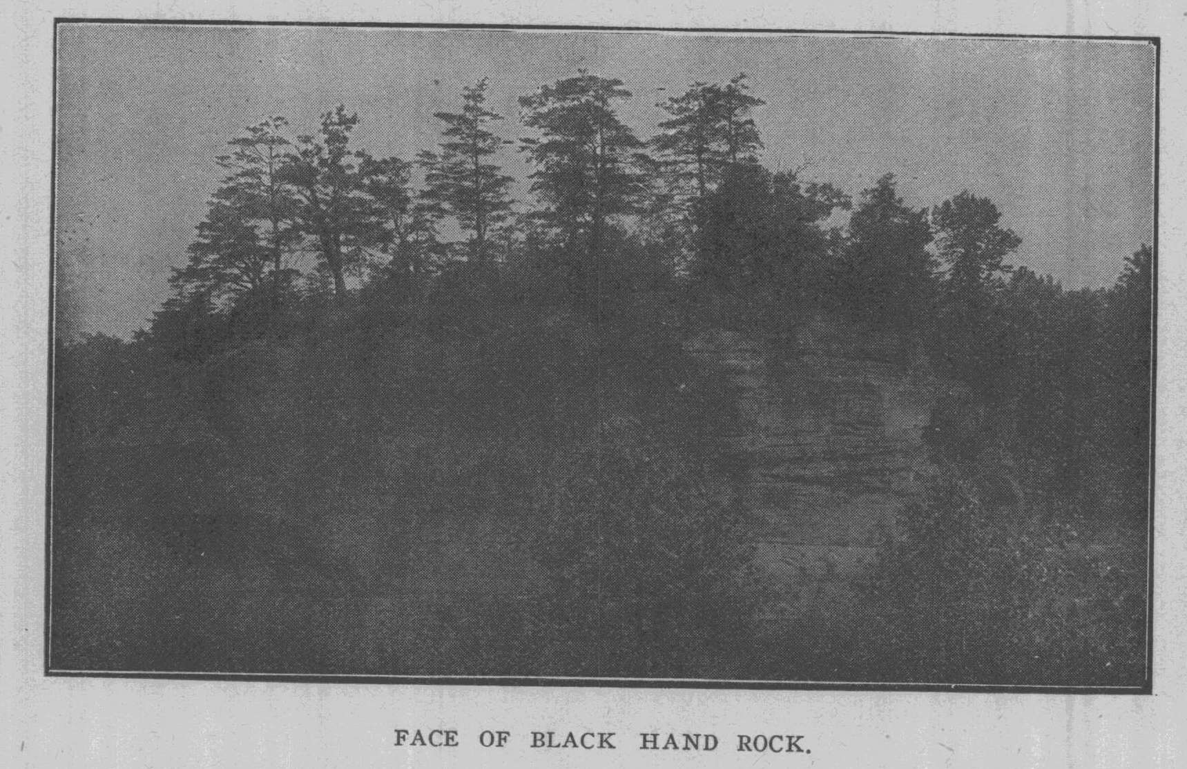
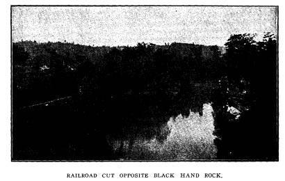
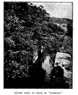
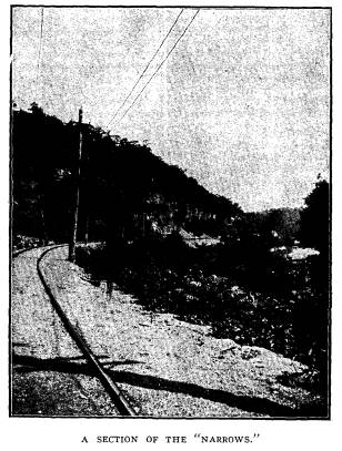
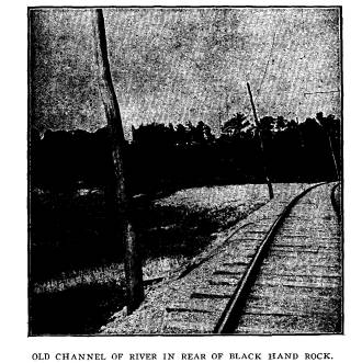
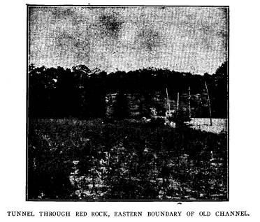
The pictures used for illustration are intended to show the massiveness of the Black Hand rock and give an idea of the ruggedness and picturesqueness of the Narrows and the peculiar change of channel, which makes so novel and interesting the po- sition of the rock itself. Two of the pictures were taken some years ago, while the dam was still standing, and the river was slack-water from the outlet lock at the head of the Narrows to the dam, which stood a short distance beyond the Black Hand. The remaining pictures were recently taken, while the river, no longer flooded by the dam, was at the stage of low water. Of the three pictures in which the Black Hand rock appears, one, |
|
|
|
taken from the Red Rock, looking west, shows the east entrance to the railroad cut opposite the Black Hand, the channel be- tween the cliffs and the river at the stage of slack water; another, taken from the railroad opposite, shows the face of the Black Hand rock, and its height in comparison with the dimly discern- ible figures standing on the towing-path across its face; the third picture looks eastward along the present channel of the river into the widening valley beyond. Now the dam is out much more of the rock is exposed to view, giving it a more massive appearance than in the older pictures. |
The Black Hand. 447
On the face of this isolated cliff the
earliest settlers found
engraved the figure of a large human
hand. Authorities differ
as to the size of the hand and the
direction in which it pointed.
The weight of evidence supports the
statement that it was twice
the normal size, with the thumb and
fingers distended and point-
ing to the east. It appeared to have
been cut into the face of
the rock with some sharp tool, and it is
probable that the form
became dark in time through natural
agencies. In 1828, when
the Ohio canal was under construction,
the river throughout the
extent of the narrows was converted into
slack-water and made
a part of the canal by constructing a
dam a few hundred yards
east of the Black Hand. It was necessary
to blast away part of
the Black Hand rock in order to make the
towing-path. In doing
so the Black Hand was removed. From the
earliest settlement
to the present, the origin and purpose
of the Black Hand have
been subjects of interesting conjecture,
and the effort to account
for them has given rise to many legends.
The Legends of the Black Hand.
These which follow have been written by
Dr. R. E. Cham-
bers, of Chandlersville, Mr. H. C.
Cochran, of near Newark,
Mrs. David Gebhart, of Dayton, and the
Hon. Alfred Kelley, of
Columbus.
In a paper by Colonel Charles
Whittlesey, entitled "Archaeo-
logical Frauds," he locates the
mound, from which the Moses or
Commandment Stone was said by David
Wyrick to have been
taken, two miles east of Jacktown and
south of the National road.
Residents of Newark who knew David
Wyrick personally, and
are familiar with all the facts assure
me that this is correct. In
the valley cast of the Red Rock, and a
few hundred yards dis-
tant, is a circle about two hundred feet
in diameter, with an
opening to the northeast, and with a
small mound in the center.
Southwest from the circle, near the
river, is evidence of a fire-
pit. Old residents tell me that
arrow-heads and flint chips were
formerly abundant in and about this circle. These, aside from
the figure of the hand, are the only
evidences of Indians, Mound
Builders, or other prehistoric
inhabitants in the neighborhood
of the Black Hand. The
statement of these facts, I hope, will
|
448 Ohio Arch. and Hist. Society Publications.
not lessen the interest of the reader in Dr. Chambers' entertain- ing effort to account for the Black Hand. In concluding his legend, Mr. Cochran says: "The name Black Hand still clings to the locality notwithstanding the vil- lage of that name has been renamed by the Post-office Depart- |
|
|
|
ment to the prosaic one of Toboso. All of the history and ro- mance and beauty of the locality, however, suggest Black Hand as the name of both village and community. The brakeman on the passenger train calls it Black Hand; if a stranger toiling along the country road asks a native the way to Toboso, he will invariably be directed on the way to Black Hand." It will |
The Black Hand. 449
doubtless be a matter of regret to
everyone that the railroad
has recently changed the name of the
station, and the brakeman
no longer calls out Black Hand, but
Toboso. It is to be hoped
that commercial as well as historic
interest will induce the new
electric line to perpetuate the name of
Black Hand.
In a beautiful introduction to her
legend, among other
things, Mrs. Gebhart says: "The
Indian legend pertaining to this
relic of a prehistoric race was told me
by Colonel Robert David-
son, who settled in Newark in 1808.
There were many Indians
there at that time, and from them he
doubtless heard it. They
lingered long in the vicinity. I
remember being carried in his
arms, probably about 1835, to see the
party who had erected
their wigwams and camped in the public
square at Newark. I
remember with especial distinctness, one
squaw who carried a
papoose, Indian fashion, on her
back. Its black bead-like
eyes seemed to view me as curiously as I
on my part viewed it
from that coign of vantage a father's
protecting arm."
Hon. Alfred Kelly was one of the canal
commissioners under
whose supervision the canals of Ohio
were made. He probably
heard the legend while engaged in this
work. His rendering
has never been published. A manuscript
copy is in the pos-
session of his daughter, Mrs. Francis
Collins, of Columbus, who
has kindly consented to its publication
here.
THE BLACK HAND.
R. E. CHAMBERS, M. D.
Some time during the fifties, articles
appeared from time to
time under the nom-de-plume of
"Black Hand." These were
devoted to a history of the "boys
and girls of 1826." They were
pleasing and readable, and were very
lavish in extolling the at-
tractive traits of character that
adorned the developing woman-
hood and manhood of that period.
At the conclusion of his article he asks
the question, "Who
put that hand on the rock ?" or who
painted the hand on the rock?
- for it had the appearance of having
been painted.
Vol. XIII-29.
|
450 Ohio Arch. and Hist. Society Publications.
This rock is near the station on the B. & O. railroad which bears the name, "Black Hand." It is on the canal bank on the borders of Muskingum county and Licking county and was a place of much note as a pleasure resort in my boyhood days. It was a large rock with a face some eight feet high with a pro- |
|
|
|
jecting rock of some feet out and even over the canal. This hand was perfect and Mr. Sheward, who had taken much pains to see if he could find its origin, traced its history back to 1816, and the first traveler found this hand on the rock. The Indians did not use the open hand as an insignia to convey or perpetuate events, hence they could not account for the hand. |
The Black Hand. 451
To give what I thought was the best
solution to a question
of so much interest, I was disposed to
use the find of David Wy-
rick and a friend, who had taken
advantage of a removal of a
large mound for the stone and dirt it
contained by the B. & 0.
railroad, a work of our prehistoric
citizens of a time we know
not of. David Wyrick and his friend, who
had been deeply inter-
ested in this mound in the years past,
and as to what it might con-
tain, determined to explore to a greater
depth than the removal
of the accumulations by the railroad.
They were not long in striking a rock in
their descent and
finding it was single and elongated
continued their work until
they uncovered it. They found the top
was of the character of a
slab, which on removal revealed the
skeleton of what was once
a human being. While decomposition had
been perfect, the mould
of the covering over the remains gave
evidence of fibers as if
the body had been clothed with a woolen
garment. They re-
moved the stone coffin and found beneath
it a stone of a foot
and a half in length, that gave evidence
of having been sharpened
and upon handling it they found that it
contained something
in its interior. They, with some
trouble, opened it, finding in-
side a stone twelve inches long and four
inches wide and an inch
in thickness. It had a neck broken off,
in the end was a hole. This
gave evidence of having been worn as if
a strap had been inserted
and it was carried in this way.
They were much astonished to find
engraved on one side an
outline or profile of a man in the dress
of a Hebrew and on the
other side characters which they could
not make anything out
of. Living in Newark, and having
knowledge of the Episcopal
minister as a man of fine education,
they went with it to him,
and he took the stone and was greatly
astonished to find that the
characters were Hebrew. He said he would
see if he could read
or decipher it. He did so. Calling to
his aid his Hebrew works,
he was able to translate nine
commandments, one was left off.
Fearing that his translation was not
correct, and having
a knowledge of Rev. Matthew Miller, of
Monroe township, this
county, who was at that time at his home
from New York, where
he had been laboring in his efforts to
convert the Jews, and
|
452 Ohio Arch. and Hist. Society Publications.
knowing that he was greatly distinguished as a Hebrew scholar, he wrote to him of the find, asking his assistance. His deep interest in that people caused his immediate trip to Newark. One of the letters or characters was not closed at the top, and for fear that he should be mistaken in view of this character, he went to Cincinnati to a Hebrew rabbi, and pre- sented to him the tablet. His translation was the same as that of the two other ministers. His attention being called to this var- |
|
|
|
iation in the letter, he said: "This is ancient Hebrew that you know nothing about." Rev. Matthew Miller said to me that the dating on this tablet ante-dated the birth of Christ eight thousand years. This hand pointed to the mound that contained the last rabbi who ministered at the altar. Doubtless when his work was done his followers gave a burial that went to show their love and esteem, in the mound they raised over his remains and the |
The Black Hand. 453
tablet, that was as a guide to their
faith, and then put the hand
on the rock, pointing to the place of
his burial.
THE MINGO CAPTIVE AND THE WYANDOT MAIDEN
AND
THE NEUTRAL GROUND.
H. C. COCHRAN.
An Indian sat at the door of a settler's
cabin and told this
story: Many years ago the red men in the
eastern part of the
state were at war with those in the
middle and northwestern part.
Chief among the former were the Mingos,
and among the latter,
the Wyandots. In one of the stealthy and
bloody incursions
into the Mingo hunting grounds, a young
chief of great promise
was captured and carried back by the
Wyandots. Instead of kill-
ing the young Mingo chieftain, as was
the usual custom, he was
made a serf and compelled to earn the
good-esteem and fellow-
ship of his captors, a fate worse than
death to the young Indian.
The woes of his captivity, however, were
lightened by the kindly
attention of a young Wyandot maiden, the
daughter of the chief
of the tribe into which the Mingo had
been adopted. Genuine af-
fection knows no condition, or it rises
above all environment. The
maiden fell in love with the unfortnate
young chief, and though
watched by the crafty tribesmen, they
made their affection known
to each other and decided to fly to the
Mingo country. One
night they made their escape. At
daylight they were missed
and were pursued by a posse of Wyandots.
The girl had left
behind a tribesman lover, who burning
with the passion of a
disappointed lover, and aching for
vengeance traveled faster
than the couple and overtook them at
Black Hand rock. They
heard the pursuers behind them, knowing
that worse than death
awaited them if captured. With the
stoicism of the savage, they
walked to the edge of the precipice and
surveyed the flood. Fold-
ing the idol of his heart in his arms,
he sprang into the boiling
waters. The pursuers were close enough
to see the last chapter
of the drama. The narrator says the
disappointed pursuers
marked the spot as the Caucasian found
it.
The other legend, one worthy of
perpetuity, is born of the
geology of the country and the trade
conditions of the aboriginees.
|
454 Ohio Arch. and Hist. Society Publications.
About five miles southwest of Black Hand is a great outcrop- ping of chalcedony. The place is known now as "Flint Ridge" and the flint, rare on this continent, was much valued by the In- dians and Mound Builders for making implements of agriculture and war. Like the pipe stone quarries of the Dakotas, where the inimical Sioux and Mandan work side by side in apparent peace, hither the tribes came up, the place being considered sacred to the giver of all good and perfect gifts. For a radius of |
|
|
|
five miles around "Flint Ridge," rested the blessing of the Great Spirit, or that of the orb of day, the divinity worshipped by the Mound Builders. None of the tumult of war was found within that space. Parties in quest of flint, coming to the confines of the charmed circle, laid down their arms for the purpose of mining the necessary stone, for the time forgetting the tradi- tionary hatred of foes. They came from the Mississippi valley, probably by water and debarked from their frail craft at the foot of the rock. The romancer says the spread hand carved on |
The Black Hand. 455
the rock was in mute appeal and forcibly
reminded the wayfarer in
a way at once forcible, as it was
poetical, that thus far and no
farther should the waves of unglutted
vengeance roll. The hand
marked the portal of a sanctuary which
was sacred to the
savage, whose lust for blood rose above
every other considera-
tion in his narrow but intense, isolated
but eventful life.
THE CHIEFTAIN WACOUSTA, THE YOUNG
LAHKOPIS, AND
THE MAIDEN AHYOMAH.
MRS. DAVID GEBHART.
"An unremembered Past
Broods like a presence, midst
These cliffs and hills."
Many moons ago, long before the pale
face came across
the Great Water to this land, here upon
the bank of the Pataskala,
was the lodge of the great chief
Powkongah, whose daughter
Ahyomah was fair as the dawn and
graceful as the swan that
floats on the lake. Her eyes were soft
and shy as the eyes of a
young deer, her voice sweet and low as
the note of the cooing
dove. Two braves were there who looked
upon her with eyes of
love, and each was fain to lead her from
the lodge of her father,
that she might bring light and joy and
contentment to his own.
At last said the chief, her father,
"No longer shall ye contend for
the hand of Ahyomah, my daughter. Go ye
now forth upon the
war path, and when three moons have
passed see that ye come
hither once more, and then I swear by
the Great Spirit that to
him who shall carry at his belt the
greatest number of scalps
shall be given the hand of Ahyomah, my
daughter." Three
months had waxed greater and grown less
ere the warriors re-
turned. Then, upon the day appointed,
behold, all the tribe gath-
ered to view the counting of the scalps.
First stepped forth Wa-
cousta, a grim visaged warrior, who had
long parted company
with fleet-footed youth, and walked
soberly with middle man-
hood. From his belt he took his
trophies, one by one, and laid
them at the feet of the chief, while
from behind the lodge door
Ahyomah, unseen by all, looked fearfully
forth upon the scene.
With each fresh scalp the clouds settled
more and more darkly
|
456 Ohio Arch. and Hist. Society Publications.
upon the bright face of Ahyomah, and her lip trembled as she murmured, "So many! so many!" Then came the second brave, Lahkopis. Young was he, with the light of boyhood still lingering in his eyes, but upon his head the eagle feather, telling withal of a strong arm and deeds of bravery. One swift glance he shot towards the lodge of the unseen maiden, then he loosed his belt, and laid it at the feet of Powkongah. Scalp after scalp they counted, while the people bent forward silently, and a little hand drew aside the curtain from the lodge doorway, and a young |
|
|
|
face looked anxiously yet hopefully forth. Slowly, slowly they laid them down, and at last, behold there was one more, just one more than in the pile of Wacousta. The young Lahkopis had won! Now strode forth Wacousta, and laid his hand--the strong right hand, that yet had failed to win the prize--laid it upon a rock. Then lifted he his tomahawk high in the air, and with one swift stroke severed the hand at the wrist, and flung it high up against the face of the cliff, saying. "Stay thou there forever as a mark of scorn in the eyes of all men, thou hast let |
The Black Hand. 457
thyself be beaten by the cunning right
hand of a boy! Disgraced
thou art, and no longer shalt thou be
numbered among the
members of my frame." And the hand
clung to the rock and
turned black, and spread and grew until
it was as the hand of
a giant; and while the chief, Ahyomah
and the tribe stood silently
watching the wonder, the defeated
warrior wrapped his robe
about him, spoke no word of farewell,
and striding swiftly into
the dark depths of the forest, was seen
no more by man.
THE BLACK HAND.
HON. ALFRED KELLEY.
Have you ever seen the place where the
murderer's hand
Had instamped on the rock its indelible
brand,
A stain which nor water nor time could
efface?
'Tis a deep lonely glen, 'tis a wild
gloomy place,
Where the waters of Licking so silently
lave,
Where the huge frowning rock high
impends o'er the wave,
On whose pine-covered summit we hear the
deep sigh
When the zephyrs of evening so gently
pass by.
Here a generous savage was once doomed
to bleed,
'Twas the treacherous white man
committed the deed.
The hand of the murderer fixed the
imprint,
'Twas the blood of the victim that gave
the black tint.
A captive in battle the white man was
made,
And deep in the wilds is the victim
conveyed,
Here far from his kindred the youth must
be slain,
His prayers, his entreaties, his
struggles are vain.
The war dance is treading, his death
song is singing,
And the wild savage yell in his ears is
a-ringing.
The fire for the torture is blazing on
high,
His death doom is sealed, here the white
man must die,
The hatchet is raised, the weapon
descends,
But quick an old chief o'er the victim
now bends.
The hatchet he seizes and hurls to the
ground.
He raises the youth and his limbs are
unbound.
"My son fell in battle,"
exclaims the old chief,
"But ye saw not my sorrow, tho'
deep was my grief,
458
Ohio Arch. and Hist. Society Publications.
And now shall the white man to me be a
son,
'Tis your chief that has said it - his
will shall be done.
A friend and a father to him will I
prove,
And me as a father and friend shall he
love."
Long years had passed by, and peace had
again
Spread her soft balmy wings over
mountain and plain,
The red man and white man in friendship
now meet,
For the hatchet is buried deep under
their feet.
Long years had rolled on, while the
chief and his son
Rich spoils from the forest together had
won.
Now loaded with furs from the far
distant lake,
The path to the traders together they
take.
Through the Narrows of Licink their
pathway extends,
Around the huge rock on its margin it
bends,
Where the shelf on its face scarce
admits them to creep
Along the dark front that impends o'er
the deep.
The chief, with fatigue and with age now
oppressed,
In the shade of the rock seeks a moment
of rest;
Here, lulled by the waters, he closes
his eyes,
While his spirit communes with his
friends in the skies.
By his side the false white man now
silently knelt,
And carefully drawing his knife from the
belt,
With one deadly plunge of the murderous
steel
Reached the heart full of kindness -a
heart that could feel.
Then quick in the river the Indian was
thrown
Lest the tale should be told, lest the
deed should be known.
Oh! the shriek that he gave as he sank
in the flood,
As the waves eddied round him,
deep-stained with his blood.
0h! the glare of his eye as they closed
o'er his head,
While with hoarse sullen murmur they
welcomed the dead.
Rock told it to rock, oft repeating the
sound,
While shore answering shore still
prolonged it around.
That look and that sound touched the
murderer's heart,
With phrenzy he reeled, and with
shuddering start,
His hand, while still reeking, with
madness he placed
On the rock, and the blood-stain could
ne'er be effaced.
|
The Black Hand. 459
'Twas avarice prompted the horrible deed, 'Twas avarice doomed the kind chieftain to bleed. To form the safe towing-path, long since that day The face of the rock had been blasted away. Now the gay painted boat glides so smoothly along, Its deck crowned with beauty and cheerful with song. And the print of the black hand no longer is seen, But the pine-covered summit is still evergreen, And still through the branches we hear the deep sigh Of the spirits of air as they sadly pass by, While in mournful procession they move one by one Still thinking with grief on the deed that was done. |
|
|

|
THE BLACK HAND.
JOHN D. II. M KINLEY. The Licking river, the Pataskala of the Indians, as it draws near the eastern boundary of Licking county, Ohio, flows in a winding course for a distance of about two miles through a nar- row and picturesque sandstone gorge, known as the Licking Narrows. High hills border upon both banks, their rocky sides |
|
|
|
exposed in many places to a height of fifty to sixty feet, almost continuously on the north bank, and often rising out of the bed of the stream. Just at the eastern end of the Narrows the river flows in its narrowest channel between twin cliffs. That on the south side has been quarried and boated way, so that it no longer shows the extent of the face originally presented to the stream, though enough remains to give an idea of its former height. That on the north side is isolated, with a surface area on its (444) |
(614) 297-2300