Ohio History Journal
- 1
- 2
- 3
- 4
- 5
- 6
- 7
- 8
- 9
- 10
- 11
- 12
- 13
- 14
- 15
- 16
- 17
- 18
- 19
- 20
- 21
- 22
- 23
- 24
- 25
- 26
- 27
- 28
- 29
- 30
A HISTORY OF FLOOD CONTROL IN OHIO
BY ARTHUR E. MORGAN AND C. A. BOCK
The great ice cap, which covered
northeastern North
America during the Glacial period, is
estimated to have
been about two miles thick in the
region north-east of
the Great Lakes. The weight of this
great mass caused
it to creep gradually toward the ocean
on the east and
toward the south, where the pressure
was less.
In this relentless advance it ground
off the hill tops
and filled up the valleys, changing the
region south of
the Great Lakes from one of hills and
valleys to a broad
plain. The ice sheet came to an end
some distance north
of the Ohio River, and from its margin
southward the
hills remained undisturbed. The hilly
country around
Cincinnati furnishes a picture of what
much of the State
would be like, but for the glaciers.
The moving mass of ice, with its burden
of boulders,
gravel and powdered rock, wiped out old
river valleys,
changed the courses of streams, and
quite remade the
surface geography of Ohio. Some of the
old river val-
leys, as the Miami River north and
south of Dayton, and
the Mad River east of Dayton, were
filled in with this
glacial debris to a depth of more than
two hundred feet.
In some parts a new surface soil was
left, composed
of this ground-up rock, known as
glacial till. On other
great areas the limestone rock was left
bare. As the
years passed, the lime was leached out
by the rains, and
the remaining impurities of the
limestone were left be-
hind to form the fertile residual soils
of central Ohio.
(474)
A History of Flood Control in
Ohio 475
Not only did the ice sheet change the
course of rivers,
but it largely wiped out the local
drainage. When white
men first visited the central part of
the state they found
a densely wooded plain, poorly drained
in many parts,
and breeding mosquitoes and other
insect pests. The
malaria or "fever and ague"
of the early days was car-
ried by mosquitoes which bred in these
undrained
swamps.
The last hundred years has seen the almost
complete
elimination of swamps from Ohio. First
by open ditches
and then by tiling, Ohio farmers have
brought almost
the whole of the flat lands of the
state into profitable cul-
tivation. Little by little a body of
laws and of judicial
decisions has grown up to define and to
facilitate the
drainage development until the drainage
code of Ohio
has become voluminous and
comprehensive, if not well
organized. The invention and building
of excavating
machinery in Ohio for digging the
ditches has developed
into thriving industries in Cleveland,
Bucyrus, Marion
and Findlay, that now find markets for
their product all
over the world, and the manufacture of
drain tile has
contributed to making Ohio the foremost
state in the
ceramic industry.
But while the farm land was being
reclaimed, flood
conditions in the main rivers were only
becoming ag-
gravated. Under primitive conditions
the flat undrained
woods served as storage basins to
retard the flow of
rain water into the rivers. The
clearing of the land,
and its drainage through large open
canals tended to
hasten the flow of storm water directly
into the larger
streams.
Omitting the Ohio River from
consideration for the
476 Ohio Arch. and Hist. Society Publications
time being, flood conditions in Ohio
rivers are due
largely to the lay of the land left by
the glaciers. The
old deep gorges were filled with
glacial debris, and in
place of narrow, deep gorges we have
flat valleys
through which the present rivers wind
their crooked
way.
Like all other rivers, these stream
channels are but
the paths worn by water flowing down
hill along the line
of least resistance. The sizes of the stream
channels
are only the chance results of the
working of natural
forces. Some rivers have channels far
too large for the
most extreme flood flow, like the Grand
Canyon in Ari-
zona, while others are too small to
care for even or-
dinary freshets. The Miami, Mad,
Stillwater and Scioto
Rivers have dug channels for themselves
about large
enough to carry the ordinary high water
occurring each
spring, but only enough to carry about
one-tenth of the
flow of the most extreme floods. The flow
in streams
under natural conditions varies
greatly. For instance,
the low water flow in the Miami River
at Dayton is at
times less than 250 cubic feet per
second, while in March,
1913, the flood flow was approximately
250,000 cubic
feet per second. Such streams during high water
periods have a tendency to build flat
flood plains by the
deposits from their muddy waters,
producing land of
great fertility.
In the first settlement of the country
it was natural
that men should locate along the
rivers, because, in the
absence of roads, the rivers were the
first highways. It
is fortunate that this was so, because
modern industry
and modern civilization demand water in
such quantities
as can be furnished only by streams of
considerable
A History of Flood Control in
Ohio 477
volume. The tendency has been not only
to improve
the fertile valley bottoms for
cultivation, but to build
factories, railroads and towns along
the river banks.
Many of Ohio's cities and villages have
been built, at
least in part, upon the flat bottom
lands along the rivers.
In times of heavy rainfall the rivers
overflow these bot-
toms, and there is great damage to
property, and some-
times a great loss of life. Cincinnati,
Portsmouth and
Marietta on the Ohio River; Piqua,
Troy, Dayton, Mid-
dletown and Hamilton on the Miami;
Springfield on
Buck Creek; Kenton, Columbus,
Circleville and Chilli-
cothe on the Scioto; Delaware on the
Olentangy; New-
ark on the Licking; Zanesville and
McConnelsville on
the Muskingum; Massillon on the
Tuscarawas; Alliance
on the Mahoning; Cleveland on the
Cuyahoga; Tiffin
and Fremont on the Sandusky; Defiance
and Toledo on
the Maumee; Findlay on the Blanchard;
Lima on Ot-
tawa River; Fostoria on Portage River;
Xenia on Shaw-
nee Creek -- all these are examples of
Ohio cities built
partly within the flood plains of
rivers, and all have
been subject to damage from floods.
While floods in Ohio Rivers were
perhaps increased
by drainage operations, yet they began
to trouble the
inhabitants before drainage operations
had begun. Day-
ton was founded in 1796, and in 1805,
while the country
was still a wilderness, a flood
occurred on the Miami
River, which did great damage to the
new settlement,
and which was larger than any later
flood for more than
a hundred years. In 1814 the Miami, at
Dayton, again
overflowed its banks 'and destroyed the
levees built just
after the 1805 flood. Other floods of
considerable magni-
tude occurred in 1828, 1832, 1847,
1866, 1886, 1897 and
478
Ohio Arch. and Hist. Society Publications
1898. Similarly destructive floods
occurred in Colum-
bus in 1828, 1838, 1865, 1870, 1883 and
1898. Other
cities also suffered serious damage
from inundation
from time to time, but in these early
floods the damage
was less severe because of the limited
industrial devel-
opment and loss of life not so great
because the popula-
tion was less dense. Furthermore in
those days a flood
was regarded more as being an act of
providence which
was not in the province of man to
control, and efforts
to ameliorate or prevent flood
conditions were limited
to purely local projects of building
levees or slight im-
provement of existing channels, and
these improvements
more often were designed solely to
prevent the overflow
of agricultural lands rather than to
protect against loss
of life and damage to property in
cities and towns.
During the past fifty years the
concentration of pop-
ulation and industries on the flat
lands of river flood
plains in Ohio has accelerated with
tremendous rapidity,
and the intense use of such lands has
created flood prob-
lems which, with the increasing value
of the property,
become increasingly difficult to solve.
The real meaning
of this growing flood menace, however,
had been only
vaguely sensed by a few hydraulic
engineers in the
country who had made some study of
floods in an inci-
dental way, and not at all by the
people at large, until
the great floods of 1913 demonstrated
the terrible pos-
sibilities of such situations. These
floods were so de-
structive to life and property and so
widespread over
the state as to cause considerable
investigation into pos-
sible methods of protection against
future flood disas-
ters. The unprecedented stages and
extreme sudden-
ness of their occurrence were
particularly disastrous in
A History of Flood Control in
Ohio 479
the Scioto and Miami valleys and gave
rise to a strong
public sentiment in Columbus, Dayton
and other cities
that such calamities must not be
permitted to recur.
On the Ohio river itself the feeling of
alarm was not so
intense, since the flood crest arrived
more slowly and
the river cities had long been
accustomed to suffer
periodical damage from inundations.
Local engineers,
county, city and state officials and Federal
Government
engineers began to take a lively
interest in flood control
problems and to study methods of
relief.
Thus as part of the general conquest of
the land, men
now are undertaking to control these
floods, so that
life and property will no longer be
endangered. In the
end, life and property are safe and the
river presents one
more case of man's mastery of his
environment. As the
most striking example of this kind of
mastery in Ohio, a
brief sketch will be given of the Miami
Valley flood con-
trol project.
THE MIAMI PROJECT
The City of Dayton was settled in 1796,
and in 1805
the first serious flood occurred, which
covered most of
the settlement. A small levee was built
to protect from
a recurrence, but it was washed out
very soon. There-
after for more than a century the city
would be flooded
from time to time, and after the flood
the levees would
be strengthened to a point where the
people would be
assured of protection. About 1910 a
flood control pro-
gram was undertaken by the city, which
was supposed
to afford protection against the
greatest possible flood.
Bonds had been issued and contracts
let, and the con-
tractor was just about to begin work
when the great
flood of 1913 swept away the
contractor's equipment,
|
|

|
(480) |
A History of Flood Control in
Ohio 481
and demonstrated again that the
proposed flood control
would have been completely inadequate.
The experience of Dayton had been
repeated in
nearly all the cities of the Miami
Valley, from Piqua on
the north to Hamilton on the south,
where successive
floods had been followed by protective
works which
were relied upon for future security.
On the 23rd, 24th and 25th of March,
1913, a rain-
storm occurred over Ohio and Indiana,
which exceeded
in area and intensity any that occurred
since the
settlement of this section. The center
of this storm
area was over the Miami Valley, where
as much as ten
inches of rain fell on March 24th and
25th. The
ground was still saturated from rains
earlier in
the year, and between 80 and 90% of this rain-
fall at once flowed into the rivers. In
the cities
on the Miami River damage to property
amounted
to more than $100,000,000, and about
400 lives were
lost. Columbus, on the Scioto River,
suffered somewhat
less severely, and nearly every town
and city in southern
Ohio, which occupied river bottom land,
was damaged.
For several weeks everyone's attention
was directed
to steps for immediate relief, but as
the debris and mud
were cleared away and the hungry were fed,
a demand
developed for permanent protection. In
Dayton a "flood
prevention" committee was
organized, and John H. Pat-
terson, President of the National Cash
Register Com-
pany, was made chairman. He was
represented on the
committee by Edward A. Deeds, Vice
President of the
National Cash Register Company, who
later was made
chairman of the committee, and was the
guiding spirit
of the whole flood prevention program.
The other mem-
482 Ohio Arch. and Hist. Society Publications
bers of the committee were Walter
Worman, Walter S.
Kidder, Edward W. Hanley, H. E.
Talbott, John W.
Stoddard, Adam Schantz and Frank
Huffman.
One of the first acts of the Flood
Prevention Com-
mittee was to pass a resolution:
* * * that there be prompt and definite
action to deter-
mine the cause of the inundation of the
city of Dayton on March
25, 1913, and to apply the
maximum of human knowledge and
scientific skill with the necessary
measure of financial resources
to prevent the recurrence of a similar
calamity.
*
* * *
* * * * *
That to enable this committee to take up
the vast program of
surveys, plans, specifications,
condemnations, contracts, and con-
struction incidental to and connected
with the work of protection
of life and property, to allay the fears
and misgivings of the
people, and to reinstate the beautiful
city of Dayton as an at-
tractive location for home life,
happiness, and commercial pres-
tige and success, there shall be
provided a Flood Prevention
Fund of $2,000,000.
This action resulted in the establishment of a
$2,000,000 fund, from subscriptions by
the citizens of
Dayton; the employment of the Morgan
Engineering
Company to make a thorough
investigation and plans
for flood control; and the organization
of the Miami
Valley Flood Prevention Association.
The work done
by this valley association was
naturally of a very gen-
eral character, and its activities did
not continue beyond
several meetings. Its chief service was
to bring to-
gether from the various parts of the
valley those men
who were taking a potential interest in
the flood control
cause, and to enlist the cooperation of
the various cities
in the valley, for the working out of
effective measures
for flood control.
Soon after the 1913 flood numerous
plans were sug-
A History of Flood Control in
Ohio 483
gested for flood protection. Many of
these, though hav-
ing the guise of engineering reports,
were developed
from meager and inaccurate data and
were at once im-
practical and wholly inadequate. The
public demand
for quick action operated in a measure
to make some
of these immature proposals a hindrance
to the working
out of an effective plan for the entire
valley. A report
of a different character was submitted
to the Chief En-
gineers of the U. S. Army1 by a board
of army en-
gineers, which among other things, set
forth the neces-
sity of making complete surveys and
investigations be-
fore the adoption of any plan.
It was along these lines that the work
at Dayton was
undertaken, one of the first of the
engineer's reports2
stating that "* *
* it has been our aim to
investi-
gate every possible method of flood
protection in
order to be assured that no
possibilities are overlooked."
This policy of thorough investigation
was largely re-
sponsible for the great forward stride
made in the prog-
ress of flood control in Ohio. The aim
of this work was,
in general, to make a complete and
coordinated survey
of flood conditions in the Miami
Valley, to develop a
comprehensive plan of protection from
further flood
destruction, to secure the adoption of
such a plan by the
several cities and parts of counties
involved, and to pro-
vide the necessary legal machinery by which such a
project could be organized, financed
and properly exe-
cuted.
A thorough study of the storm rainfall
records of the
1 Report to Chief of Engineers, U. S.
Army, May 26, 1913, by Special
Board of Army Engineers.
2 Preliminary Report of Morgan
Engineering Company, Oct. 3, 1913.
484 Ohio Arch. and Hist.
Society Publications
Eastern United States developed that
while the 1913
precipitation was unusually intense and
covered a large
area, it was not impossible for a
somewhat greater rain-
fall to occur on a similar area. Such
extreme rainfalls
would come only at long intervals, but
it was felt in the
Miami Valley that any flood control
works to be built
should now be made adequate to give
complete protec-
tion.
Contrary to the general expectation, it
was found
that a system of retarding reservoirs,
to hold back ex-
cessive flood waters, combined with
some channel im-
provement through the cities and towns,
afforded the
best plan for flood protection in the
valley. It was also
found that while it was financially
impossible for any
one of the cities alone to secure
complete protection, a
coordinated system of control for the
valley was en-
tirely feasible. When these findings
were made known
to the Flood Prevention Committee by their
engineers,
four great obstacles, interwoven with
the intricate com-
plications of many minor difficulties,
presented them-
selves. These were, briefly:
(1) Local oppositions caused by
ignorance or mis-
understanding of the plans.
(2) Lack of cooperation among various
cities af-
fected.
(3) A general prejudice, somewhat vague
but very
definite in its effect, against the use
of reservoirs for
controlling floods.
(4) No laws existed in Ohio under which
such a
project could be legally organized,
financed, executed
and maintained.
A History of Flood Control in
Ohio 485
An educational campaign was immediately
instituted
in the Valley to overcome the first
three difficulties.
Wide publicity was given the plans in
local newspapers
and magazines, and many talks
illustrated with slides,
maps, diagrams and statistics, were
given at public
places and every opportunity possible
afforded for the
public to become informed. A working
model was made
of one of the proposed retarding
reservoirs, and this
photographed in action. Both the model
and the picture
of its operation were exhibited in many
places. One of
the most stubborn phases of the
opposition was that of
farmers living in or near the proposed
retarding basins,
based largely upon the
misrepresentation of local attor-
neys that not only would their lands be
confiscated but
they would be taxed as well, to carry
out the project.
Early in the investigations the
engineers requested
the appointment of a board of
consulting engineers,
which was composed of nationally known
experts. The
independent investigation of these men
furnished a solid
moral backing. The thorough analyses of
the plans
made by one member of the board*, and
his whole-
hearted support of them, were
particularly useful in
combating the prejudice against dams,
which owed its
origin largely to some previous reports
by government
engineers questioning the advisability
of using retard-
ing dams for flood control on the upper
Ohio river
tributaries.
The numerous laws of Ohio governing the
construc-
tion of ditches, bridges, sewers,
levees, channels, dams
or other structures that might be a
part of an extensive
* Late General H. M. Chittenden,
Consulting Engineer to Flood Pre-
vention Committee.
|
|

|
(486) |
EXPLANATORY NOTE
The diagram on the page opposite shows
the successive steps
taken under the Conservancy Law of Ohio
from the time the
petition for the organization of the
district is filed until the con-
struction of the works is begun.
The arrows in each case start at the
party taking the action
and point to the party with whom the
action is taken. For ex-
ample -- Beginning at the upper
left-hand part of the dia-
gram, and following the first two arrows
from left to right, it
will be seen that action under the law
is started by the prop-
erty owners filing a petition and bond
with the court. Following
the third arrow from right to left, we
see that the court then
publishes notice of a hearing on the
petition. Thereupon, fol-
lowing the fourth arrow from left to
right, we see that the prop-
erty owners may file objections with the
court to the organiza-
tion of the district, and so on.
A brief inspection of the diagram will
show that the funda-
mental principles involved in the law
are few and simple. The
Court of Common Pleas exercises the most
important functions
in the proceeding. Certain matters of
procedure are handled
for the court by the Directors who act
as the business managers
of the district, and by the Appraisers.
Both the Directors and
Appraisers are appointed by the Court
and their principal acts
are subject to the approval of the
Court.
(487)
488
Ohio Arch. and Hist. Society Publications
flood control system had been
individually conceived
and enacted for particular limited
problems and local
necessities, and were wholly lacking in
the compre-
hensive provisions required for a large
cooperative un-
dertaking. They did not furnish legal
machinery for
uniting the many interests needing
flood protection into
an effective organization, provided no
means for work-
ing out and officially adopting a satisfactory
plan, of-
fered no means for safeguarding
individual and col-
lective interests and rights, and
established no practical
basis for an equitable distribution of
the cost of so large
an undertaking. Neither did the
existing laws provide
authority for enforcing the
requirements of such a
project. This situation resulted in the
drafting of the
"Conservancy Act of Ohio."
The problem of preparing this law was
approached
from the engineers' point of view. The
law must be de-
signed to provide wide freedom of
action to carry out
any type of improvement; an effective
agency for get-
ting results, such as corporation form
of management;
freedom from politics; governmental
powers, such as
right of eminent domain; police powers
and taxing pow-
ers; harmony with existing laws;
cooperation among
governmental units and private
organizations; control
over stream obstructions and over the
use of water;
and general adaptability suitable to
any situation and
must be comprehensive enough so as not
to need amend-
ment for problems that might arise in
other parts of the
state. As finally enacted on March 17,
1914, the Con-
servancy Act provides for the
establishment of con-
servancy districts in Ohio, through
petition of property
owners to the court of common pleas of
any county
A History of Flood
Control in Ohio 489
wholly or partly
within the proposed district, for any or
all of the following
purposes:
(a) preventing floods;
(b) regulating stream
channels by changing, wi-
dening, and deepening
the same;
(c) reclaiming or filling wet and overflowed
lands;
(d) providing for irrigation where it may be
needed;
(e) regulating the flow of streams;
(f) diverting, or in whole or in part
eliminating
water courses; and
incident to such purposes and to
enable their
accomplishment, to straighten, widen,
deepen, change,
divert, or change the course or terminus
of, any natural or
artificial water course; to build res-
ervoirs, canals,
levees, walls, embankments, bridges, or
dams; to maintain,
operate and repair any of the con-
struction herein
named; and to do all other things nec-
essary for the
fulfillment of the purposes of this act.
A conservancy district
may be established by a ma-
jority decision of a
court consisting of one common pleas
judge from each county
having land in the district. This
Court becomes the
"Conservancy Court" of that dis-
trict, and appoints a
board of three directors to manage
the district, who in
turn may employ engineers, attor-
neys and other
assistants as deemed necessary. A plan
for the improvement is
prepared by the chief engineer
and passed upon by the
board of directors, is submitted
to a formal hearing of
objections and then subject to
the approval of the
court. An appraisal of benefits and
damages resulting from
the execution of the proposed
490 Ohio Arch. and Hist. Society Publications
plan is made by a board of three
appraisers appointed
by the conservancy court. This
appraisal is also sub-
ject to a hearing of exceptions before
it can be approved
by the court for the issue of the bonds
to finance the
construction. Any owner has the right
to appeal from
his award of benefits or damages. No
property can be
confiscated, -- and damage must be paid
where damage
is sustained. The diagram on page 15
shows the suc-
cessive steps in the operation of the
Conservancy Act.
The law was rigidly tested as to
constitutionality, and
successfully withstood several attempts
for its repeal
and amendment. Only the most earnest
efforts of the
Flood Prevention Committee and its
engineers, backed
by newspapers, churches, chambers of
commerce and
other institutions, made it possible to
preserve the law
in its complete original form through
these political
struggles in the legislature. Ohio thus
was provided
with the most comprehensive and
effective legal machin-
ery in this country for dealing with
any water control
or conservation problem that might
arise.
On the day following the signing of the
Conservancy
Act by Governor Cox a petition was
filed for the estab-
lishment of the Miami Conservancy
District. A court
of ten common pleas judges was convened
on March 20,
1914, to hear this petition, and an
attendance of over
2000 people evidenced the wide interest
in the proceed-
ings. Attorneys for the opposition
entered objections
to the jurisdiction of the court,
raised questions of con-
stitutionality of the Act and secured
some delay, and on
April 18 the court voted 5 to 4 in
overruling all the ob-
jections, one judge being absent. Since
a vote of 6, or
A History of Flood Control in
Ohio 491
a majority of the ten judges was
required, the result
was a failure to establish the
district. This was followed
by much legal procedure, by which the
constitutionality
of the Act was firmly established and
during which the
working out of engineering and
construction features
went steadily forward. On June 28,
1915, the court
formally created the Miami Conservancy
District and
appointed as its directors Colonel
Edward A. Deeds,
Henry M. Allen and Gordon S.
Rentschler. The di-
rectors immediately arranged for the
engineers of the
Flood Prevention Committee to continue
the work,
and appointed other necessary
assistants. In January,
1916, the district was furnished a
splendid home in the
newly completed Conservancy Building in
Dayton pre-
sented to the project by Colonel Deeds.
This housed
the administrative, engineering and
appraisal forces of
the district and is now being used as a
permanent re-
pository for the records. It stands on
the bank of the
Miami River as a fitting monument to
the earnest efforts
of its donor and to the great
pioneering work of the
valley for progress in flood control.
In developing and perfecting plans for
the flood con-
trol system for the Miami Valley,
probably the most ex-
tensive and thorough investigation ever
undertaken of
rainfall and floods, flow of water in
open channels, the
effects of a system of combined
reservoirs and channel
improvement, and allied hydraulic
problems, was made.
All available related data was secured
from federal gov-
ernment, state and private sources and
thoroughly
analyzed, and considerable information
from foreign
countries was investigated. The results
of these studies
|
|

|
(492) |
A History of Flood Control in
Ohio 493
have been largely set forth in a series
of ten technical
reports issued by the District.*
These volumes make available to the
resident of the
state and to the technical world at
large much data that
will have considerable usefulness in
other similar
projects.
A complete plan for the control of
floods in the
Miami Valley was submitted to the board
of directors
of the district by the chief engineer
early in 1916, and
the letter of transmittal stated, in
part:
Following the organization of The Miami
Conservancy Dis-
trict by order of the court on the 28th
of June, 1915, the appoint-
ment of your board on the 28th of June,
1915, as the board of
directors of the district, and the
appointment dated the 7th of
July, 1915, of the undersigned as chief
engineer of the district,
with instructions to prepare a plan for
the protection of the dis-
trict from floods; he proceeded to
prepare such a plan, which is
herewith presented for your
consideration, with the recommenda-
tion that it be adopted as the Official
Plan of The Miami Con-
servancy District, as provided for in
Section 12 of the Conserv-
ancy Act of Ohio. In the preparation of
the plan, your engineers
have supplemented and completed the data
secured and the work
done by The Morgan Engineering Company
under the direction
of The Dayton Flood Prevention
Committee. * * *
When this plan is carried into effect
the Miami Valley, in our
opinion, will be permanently protected
from serious damage by
flood. In its necessity for flood
prevention, the valley is not
unique. Wherever, along the rivers of
this country, industrial
and agricultural development reaches a
high stage, the protection
of these interests from damage by
uncontrolled flood waters be-
comes necessary, and must be secured
before permanent pros-
perity is established.
* Technical Reports, Miami Conservancy
District; I The Miami
Valley and the 1913 Flood, II History of
the Miami Flood Control
Project, III Hydraulic Jump and
Backwater Curves, IV Calculation of
Flow in Open Channels, V Storm Rainfall
of the Eastern United States,
VI Contract Forms and Specifications,
VII Hydraulics of the Miami
Flood Control Project, VIII Rainfall and
Runoff in the Miami Valley, IX
The Accounting and Cost Keeping System
of the Department of Engineer-
ing and Construction, and X Construction
Plant and Methods as used
on the Miami Conservancy Project.
494
Ohio Arch. and Hist. Society Publications
In the preparation of the plan a
considerable amount of orig-
inal engineering investigation has been
carried on by the engineer-
ing force. * * *
This report was printed in three
volumes and accom-
panied by two volumes of photographic
reproductions
and drawings. It included a description
of the plan, list
of properties affected, specifications,
plans, estimates of
quantities and cost, and much detailed
information for
use in constructing the works. This
plan was adopted
by the board of directors as the
Official Plan of the dis-
trict on May 10, 1916.
On October 3, 1916, the conservancy
court, composed
of nine common pleas judges, convened
in Dayton for a
public hearing on objections to the
plan. This hearing
was notable on account of the large
amount of expert
testimony submitted and because of the
most complete
and orderly presentation and
explanation of the plan by
the engineers of the district. It continued
over a period
of seven weeks and the testimony fills
over 3000 type-
written pages. On one occasion the
chief engineer for
five consecutive days replied to a
continuous cross-ex-
amination by the opposing attorneys.
Added to his tes-
timony was that of T. W. Jaycox,
consulting engineer
of Denver, with extended experience in
the construction
of earth dams in the West; of F. J.
Fischer, construction
engineer of the Los Angeles Water
Supply Commission;
of Brigadier-General William H. Bixby,
former Chief
of Engineers, U.S. Army; of Daniel W.
Mead, hy-
draulic engineer of Madison, Wisconsin;
and of Briga-
dier-General H. M. Chittenden, of
Seattle, Washington,
also former Chief of Engineers, U. S.
Army. These
engineers expressed unqualified
approval of the official
A History
of Flood Control in Ohio 495
plan.
General Chittenden stated on the stand that this
plan had
been worked out with more care and thorough-
ness than
any engineering project of which he had any
knowledge.
He took occasion to say particularly that
the Panama
Canal was not an exception. On November
24, 1916,
the court formally approved the official plan.
A report
subsequently issued by the Ohio Flood
Board of
Army Engineers made the following refer-
ences to
the official plan:
It is
probable that the best protection for Dayton under exist-
ing
conditions would be dams, one each on the Stillwater, Upper
Miami, and
Mad Rivers, just above Dayton, so designed as to
reduce the
maximum standard storm discharge at Dayton to an
amount which
can be economically and safely cared for by im-
provement of
the Dayton channel, which is probably not less than
100,000
second feet.
* *
* * * * *
* *
Adequacy of
the Plans -- It was felt by those concerned that
a project
involving such a large sum, in order to justify the ex-
penditure,
should furnish as complete protection as possible. Re-
alizing this
the conservancy district has based the reservoir ca-
pacities and
channel improvements upon a standard storm
greater in
intensity than that of 1913. The standard storm was
adopted
after an exhaustive search covering the records of all
storms east
of the Rocky Mountains so far as the U. S. Weather
Bureau files
record them. * * *
* *
* * * * *
* *
Spillways --
In order that the dams shall not be overtopped
their safety
is secured by means of spillways which are adequate
to care for
a storm far in excess of the standard storm.
* *
* * * *
* * *
The
reservoirs proposed above Dayton are well located to se-
cure the
maximum benefit for that city. They are sufficiently
near to
control all but 70 square miles of the entire drainage area
above
Dayton. This 70 miles is not believed to be extensive
enough to cause any
danger to Dayton due to severe local storms.
496
Ohio Arch. and Hist. Society Publications
* * * While the plan does not include
the entire valley, it
aims to provide protection for all
places where such protection
is most urgently needed so far as can be
economically justi-
fied. * * *"
The next task before the district was
the appraisal
of the benefit and damages to be
assessed against the
properties affected by the execution of
the plan. This
was a gigantic job by reason of the
many thousands of
pieces of property involved. The work
had already
been outlined and methods and
principles to be followed
in its accomplishment had been
developed by the en-
gineers during the legal proceedings
leading to the ap-
proval of the plan. The board of
appraisers hired a
large corps of assistants to carry out
the listing, exam-
ination and description of properties.
Their report was
filed with the court in May, 1917. It
furnished an up-
to-date valuation of about 65,000
pieces of property and
stated in each case the appraisal of
benefits or damage
entailed by each parcel from the
execution of the plan.
The court concluded its hearings on the
appraisal report
in July, 1917, and issued a decree
approving benefits in
the amount of $77,000,000. This was
about three times
the estimated cost of the project.
Conditions for financing were very
unfavorable be-
cause the war was absorbing practically
all available re-
sources. The National City Company,
however, indi-
cated its willingness to underwrite the
bond issue if the
U. S. Secretary of the Treasury offered
no objection to
financing the work at this time. The
situation was ex-
plained to Mr. McAdoo, who replied:
You call attention to the fact that the
flood of March, 1913,
destroyed four hundred lives, left forty
bereft of reason, and
caused a property loss approximating one
hundred million dol-
A History of Flood Control in
Ohio 497
lars, and that the loss of life would
probably have been thousands
had the flood occurred later in the
morning. * * *
Both from what you tell me and from my
general knowledge
of the situation, I am of the opinion
that the preservation of
human life and the public welfare are
concerned in this con-
servancy project, and that I ought not
to offer any objection to its
prompt completion.
Permit me to express my appreciation of
your patriotic action
in consulting me concerning this matter
and requesting my opin-
ion before attempting to finance this
work at this time. * * *
The first bonds issued, totaling
$15,000,000, were
placed on the market in December, 1917.
An effort was made to let the
construction of the
project by contract. On account of war
conditions,
however, all proposals tendered on the
major part of
the project were irregular, the
contractors going so far
in qualifications to protect themselves
against possible
contingencies that the district could
gain nothing by
awarding the work to them. Thus it was
decided that
the district would accomplish the
construction with
forces employed directly by the
district and with equip-
ment purchased for the purpose.
The works to be constructed included
extensive chan-
nel deepening, widening, and
straightening at Dayton,
Hamilton and other locations, the
building of five large
earth dams with concrete outlet and
spillway works, the
relocation of three steam railroads and
one electric rail-
way for considerable distances, and the
building of
various bridges, roads, walls, bank
revetment, sewers,
water lines, power lines, and
incidental works. The
channel improvements required over five
million cubic
yards of excavation and half that
amount in levee em-
bankments, and the dams required the
placing of over
ten million cubic yards in embankment.
The project
498
Ohio Arch. and Hist. Society Publications
naturally divided into seven major
construction units,
of which the most widely separated were
about 75 miles
apart. Being centrally located, Dayton
was selected for
the general headquarters of the
construction organiza-
tion. Special telephone lines were
built to establish di-
rect communication with the various
units.
In order to accomplish the work within
a reasonable
time it was necessary to secure
adequate and effective
machinery, tools and plant. This
included a large va-
riety of equipment such as large dredge
pumps, electric
motors, pipes, railroad locomotives,
dump cars, steam
and electric hoists, trucks, derricks,
concrete mixers,
complete gravel washing and screening
plants, drilling
rigs, cable ways, etc. The excavating
machinery in-
cluded 21 dragline machines, ranging in
size from small
machines with only a 30-foot boom to
150-ton machines
with 3 to 5 cubic-yard buckets and a
reach of 100 to 135
feet. At Dayton the equipment included
four large river
scows, 80 to 120 feet long, for hauling
materials exca-
vated from the channels, and for
mounting one of the
large excavators, and a river type 20
ft. by 70 ft. steam-
boat for moving the river equipment.
The value of this
construction equipment approached
$2,000,000.
In order to furnish adequate facilities
for repairs and
to insure the proper maintenance of the
construction
plant, a central shop was established
in Dayton, with a
general warehouse adjacent, which
carried large stock
of supplies, tools, repair parts and
small equipment.
Also a garage and auto repair shop
furnished facilities
for hauling, and for maintaining the
fleet of trucks and
automobiles used on the project. These
facilities proved
invaluable not only in reducing the
cost of repairs but
The Miami Project 499
in the great amount of time saved on
the work in re-
ducing delays for repairs to a minimum.
During the period of the United States'
participation
in the World War, labor rates were high
and it was
difficult to get and retain efficient
workmen. An em-
ployment bureau was established at the
Dayton head-
quarters and systematic records kept of
the labor used
on the job. No camps were established
in the cities but
for the work at the dams comfortable housing
was fur-
nished for the workmen by building
suitable quarters at
each dam site. These villages were
built to meet the re-
quirements of the several jobs and
included rooming
houses and bunkhouses for single men,
as well as houses
for married men and their families, and
were equipped
with water supply, light and sewerage.
Each village
was provided with a store, a mess hall
and a school
building, and special teachers were
employed by the dis-
trict to insure adequate facilities for
the children of the
workmen. The district also employed a
physician to
take care of medical needs of its
employees. A central
commissary plant, including a bakery,
cold storage and
ice plant, located at the Taylorsville
Dam, distributed
bread, meat and other supplies to the
various jobs. At
the completion of the project the
buildings in these vil-
lages were for the most part sold and
dismantled. Those
at the Englewood Dam, however, were
left on the site
and are now occupied and form the
nucleus of a thriv-
ing permanent community.
Considerable land was required for
right of way on
which to build the dams, levees and
other structures.
Furthermore it was necessary to buy the
right to flood
other lands within the reservoir
basins. Many owners
|
|

|
(500) |
A History of Flood Control in
Ohio 501
objected to selling such flood
easements and preferred
to sell their land outright to the
district. In the Huff-
man basin it was found necessary to
purchase the entire
town of Osborn, which was moved to a
new location.
The district thus acquired real estate
to the value of
over $7,000,000. A land department was
installed to
administer this property. Such real
estate as is not re-
quired permanently by this district is
being sold as rap-
idly as feasible, retaining the
necessary flood easements.
The execution of the plan carried with
it many inci-
dental improvements of great value to
the communities
affected, and which otherwise would
have been impos-
sible of attainment, or long delayed.
These included
the providing of park areas, highway
and street im-
provements, bridge improvements and the
reservation at
the several retarding basins of
extensive beautiful tim-
bered areas for public park purposes.
At Hamilton it
made possible the development of a
water power and
factory site which induced the building
of a large fac-
tory in that city.
The size of the project and the unique
character of
its works has attracted considerable
attention in this
country and Europe. Other reasons for
the wide local
interest are that it is one of the
largest public works
ever undertaken in Ohio, that it will
influence in a
marked degree the development of the
Miami Valley,
that it occasioned the enactment of the
most complete
and practically useful conservancy law
in use in this
country at the time, and that it is the
first project of
considerable size in this country to
utilize the system of
combined retarding basins and channel
improvement for
flood control only. On account of the
large number of
|
|
|
(502) |
|
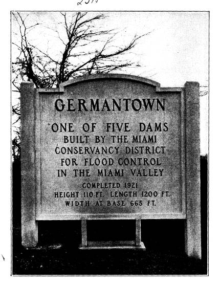
A History of Flood Control in Ohio 503 visitors inspecting the works a concrete tablet, like that shown on page 502, was erected at each of the dams. In order to serve as a permanent reminder of the sole purpose for which the dams were built, a stone was set at each site, or incorporated in the structure, bearing the following inscription: The dams of the Miami Conservancy District are for flood prevention purposes. Their use for power development or for storage would be a menace to the cities below. |
|
|

A HISTORY OF FLOOD CONTROL IN OHIO
BY ARTHUR E. MORGAN AND C. A. BOCK
The great ice cap, which covered
northeastern North
America during the Glacial period, is
estimated to have
been about two miles thick in the
region north-east of
the Great Lakes. The weight of this
great mass caused
it to creep gradually toward the ocean
on the east and
toward the south, where the pressure
was less.
In this relentless advance it ground
off the hill tops
and filled up the valleys, changing the
region south of
the Great Lakes from one of hills and
valleys to a broad
plain. The ice sheet came to an end
some distance north
of the Ohio River, and from its margin
southward the
hills remained undisturbed. The hilly
country around
Cincinnati furnishes a picture of what
much of the State
would be like, but for the glaciers.
The moving mass of ice, with its burden
of boulders,
gravel and powdered rock, wiped out old
river valleys,
changed the courses of streams, and
quite remade the
surface geography of Ohio. Some of the
old river val-
leys, as the Miami River north and
south of Dayton, and
the Mad River east of Dayton, were
filled in with this
glacial debris to a depth of more than
two hundred feet.
In some parts a new surface soil was
left, composed
of this ground-up rock, known as
glacial till. On other
great areas the limestone rock was left
bare. As the
years passed, the lime was leached out
by the rains, and
the remaining impurities of the
limestone were left be-
hind to form the fertile residual soils
of central Ohio.
(474)
(614) 297-2300