Ohio History Journal
OUTLINE OF FACTS RELATED TO THE BURIAL
PLACE OF JOHN CHAPMAN
By WESLEY S. ROEBUCK, February 15,
1942; revised July 3, 19431
1. Location of Henry Cassel's land, the
burial place of John
Chapman and others
Description of land:
The N 1/2 of SE 1/4 Section 19, T 31 N
of R 13 E; and the
S 1/2 NE 1/4 Section 19, T 31 N of R 13 E, east of the St. Joseph
River, Allen County, Indiana, 165 acres;
three miles up the
St. Joseph River from the confluence of
the St. Mary's River on
the east side of the St. Joseph River.
Three miles from Fort
Wayne.
2. Death of Chapman
John Chapman died at the house of
Richard Worth, some-
time between March 10 and 17, 1845.
References:
a. It is recorded in the Copies of
Papers in the Estate of John
Chapman, Allen County, Indiana, pages 16, 17, that Richard
Worth was allowed $8.75 for boarding,
and $13.44 for sickness
and laying him out.
b. In a notarized statement dated
September 3, 1934, James
Ayers, age 68, a son-in-law of Jacob
Parker, and a nephew to
Christian Parker, related to a
conversation with Christian Parker,
which reads in part: "He stated
that at the time of Johnny Apple-
seed's death, he was running a sawmill,
and that Johnny Appleseed
died one night at the home of Worth. The
following morning
Worth came to the Parker mill to tell
Christian Parker that 'the
old man,' meaning Johnny Appleseed,
'died last night'."
c. Eben Miles Chapman, a son of Miles
Eben Chapman, and
whose grandfather's name was Andrew
Chapman, who was a
1 The report of the Commission appointed
by the American Pomological Society
appeared in the April-June, 1943, issue.
This additional information completes the
investigation of the Commission.
(276)
|
BURIAL PLACE OF JOHN CHAPMAN 277 |
|
|
278
OHIO ARCHAEOLOGICAL AND HISTORICAL
QUARTERLY
brother of John Chapman. At the age of
76, Eben Miles Chap-
man, in his notarized statement of
October 23, 1934, relates in
part: "When we used to water our
horses and oxen at the spring
[the spring referred to was on the Henry
Cassel land] there was
a log cabin about ten feet by twelve
feet located about twenty-five
or thirty feet south of the spring. I
never saw the occupant of
this house but apparently it was
occupied by a trapper for there
always were coon and other hides nailed
up on the outside of it
when I was there."
d. In a statement made on October 10, 1928, by the late
Dr. Walter Langtry in the presence of
the late J. M. Stouder,
which reads in part: "Dr. Langtry
informed me that Mr. Parker
described a log cabin and a spring
nearby."
e. In October, 1935, Mr. W. S. Roebuck,
assisted by King
Chapman (the latter is believed to be a
great-great-nephew of
John Chapman), excavated at the spring
and found evidence of a
cabin at the place close to the edge of
the bank above the spring.
The log cabin evidently had been burned
down, for the ground
logs were traced by the charcoal. The
trenches where the logs
laid were about 15 inches deep and 16
feet long. There were
three trenches about 16 feet apart. This
would make the building
about 16 feet by 32 feet. We
discovered three ash piles 18 inches
below the surface, not far from the site
of this building.
3. Burying Ground
Elenore Parker Ayers, in a sworn
statement dated Septem-
ber 14, 1934, states in part: "In
my early childhood there was a
little burying ground, about one-half
acre in size, fenced off on
my Uncle Christian Parker's farm just
west of the place where
the reservoir stands on what is now the
W. S. Roebuck farm.
Some of my Uncle Christian Parker's
infant children were buried
in this little cemetery. I remember
distinctly hearing my father
and my uncle relate stories about Johnny
Appleseed and that he
died in the home of Worth and was buried
in the little cemetery on
my Uncle Christian Parker's farm in a
coffin made by my father
and my Uncle Christian Parker at their
sawmill nearby
"On December 1, 1928, I was
interviewed by J. M. Stouder,
BURIAL PLACE OF JOHN CHAPMAN 279
since deceased, concerning my knowledge
of the death and burial
of Johnny Appleseed. At that time I
made, signed and delivered
to Mr. Stouder the following written
statement: 'I remember my
father, Jacob L. Parker, and Christian
Parker stating the fact that
they and Uncle Dave Parker buried Johnny
Appleseed on the
east side of the St. Joseph River. It
was near an oak tree on
what is now known as the Roebuck
farm'."
On September 4, 1934, in a written
statement to J. M.
Stouder, she related that she remembered
that "such burial ground
was located as described on the Roebuck
farm, and that the Blume
family took up the remains of two
children that had been buried
there and moved them to another cemetery.
That two children of
the Stufflebean family were buried in
this cemetery."
In a written statement signed by Dr.
Walter Langtry on
October 10, 1928, he
refers to a conversation with Christian
Parker along in the eighties, which
reads in part: "Do you see
those three trees," pointing to the
same standing down near the
St. Joe River. He said, "He [John
Chapman] is buried within
two or three fence panels from those
trees which is located on
the east side of the river, and which is
now known as the W. S.
Roebuck farm."2
In a notarized statement, dated
September 3, 1934, James
Ayers, age 68, relates in part a
conversation with Christian Parker:
"The old river road, formerly known
as the 'Indian Trail,' which
ran along the St. Joseph River, east of
the river and past the
west side of what is now known as the
Roebuck reservoir hill. Mr.
Parker further stated that there was a
graveyard below the afore-
mentioned hill and that it was 'quite a
historical spot because
Johnny Appleseed was buried
there.'"
In a statement dated August 24, 1936,
Mrs. Ida Halter Shelly
says: "I have often heard my
grandfather Christian Parker tell
that John Chapman (Johnny Appleseed)
died at the home of
Worth and that he and his two brothers
made the coffin out of
lumber at their sawmill, and that he was
buried on the north plat
of ground which has since become the
Roebuck farm."
2 Christian Parker, at the time of this
conversation with Dr. Langtry, was living
at his home, which is 1,000 feet
directly east of the southeast corner of the Cassel-
Roebuck land, and also where he lived at
the time of John Chapman's death. The
three trees were visible then, because the view was not
obstructed.
280
OHIO ARCHAEOLOGICAL AND HISTORICAL QUARTERLY
Eben Miles Chapman, in a notarized
statement dated October
23, 1934, declares in part: "At
that time there was also an old
graveyard or burying ground about
one-quarter of a mile south-
west of the spring and about 500 or 600
feet west of what is now
the reservoir on the Roebuck farm. My
father often took me over
to this burying ground and told me that
my Great Uncle 'Johnny
Appleseed' was buried there. The first
time I visited this spot I
saw two depressions in the ground about
the size of a grave. The
place was grown up in weeds, and there
was no fence around it.
Once when my father and my Uncle Timothy
and I were coming
to town we stopped at this spring. On
that occasion, my father,
my Uncle Timothy, and I went over to
this burying ground,
and Father and Uncle Timothy got out
their jack knives and cut
away all the weeds around the grave, in
which they said Uncle
Johnny Appleseed was buried. My father
once visited my Uncle
Timothy at his home in Ohio. Uncle
Timothy lived about one-
half mile south of the old [Wabash and]
Erie Canal and one-half
mile east of the Indiana-Ohio line, and
was a section foreman on
the Wabash Railroad. The railroad ran
close to Uncle Timothy's
house. When my father returned home he
told me that on a Sun-
day he and Uncle Timothy had taken their
axes, got on a hand
car and came to Fort Wayne. From Fort
Wayne they walked out
to this burying ground and with their
axes cut some poles and
built a three-pole fence around Uncle
Johnny's grave, which my
father told me was the fence he and
Uncle Timothy built. My
Uncle Timothy once told me that he
attended Uncle Johnny's
funeral. He said there were only a few
people at the funeral and
that he was the only relative present.
At the time of my boy-
hood visits to Uncle Johnny Appleseed's
grave there was a log
cabin about two hundred feet southwest
of the place where he was
buried. About one-half of this cabin was
rotted down when I saw
it. Both my father and my Uncle Timothy
told me that Johnny
Appleseed lived in it part of the time
when he was in Indiana."
We read from a notarized statement,
dated September 24,
1934, signed by E. A. Nuttle: "That
as a boy he often heard his
maternal grandmother, Mary Jane Platter,
who resided on the
banks of the Maumee from 1836 to 1902, talk of John Chapman
BURIAL PLACE OF JOHN CHAPMAN 281
with whom she was well acquainted by
reason of his visits to her
home. Affiant says that he has heard
Mary Jane Platter say that
Johnny Appleseed died at the home of a
pioneer by the name of
Worth, residing along the St. Joe River
in St. Joe Township.
That he was buried in a coffin made by
some of the neighbors and
distinctly recalls her mentioning the
name of Parker as one of
those who assisted in the construction
of the coffin; that he has
also heard her say that Johnny Appleseed
was buried in a little
graveyard along a trail paralleling the
east bank of the St. Joe
River."
Old Indian Trail
A notarized statement, dated October 23,
1934, signed by
Eben Miles Chapman, reads in part:
"There was a trail running
from the main road to the spring on the
Roebuck farm and then
around a hill through a ravine to the
east bank of the St. Joe
River.
"Within the past thirty days I have
visited the W. S. Roebuck
farm two or three times. I have retraced
as best I can the trail
that ran from the St. Joe road, past the
spring over the hill and
on down to the river, and marked it's
route with stakes stuck in
the ground."
James Ayers in his notarized statement
dated September 3,
1934,
makes the following remarks: "I called Mr. Christian
Parker's attention to the fact that so
many old orchards were
located so far back from the St. Joe
road, indicating that the
houses had been likewise located so far
from the road. And I
asked Mr. Parker the reason. Mr. Parker
said that the houses
had not been originally built nor the
orchards planted to be near
the St. Joe road, which was not then in
existence, but that they
had been located facing the old river
road, formerly known as
'the Indian Trail' which ran along the
St. Joseph River3 and past
3 The St. Joseph River was called the
Bean River by the Indians, taking its
name from the bean patches grown by them
among the sand hills on the east side
where their village was. This land is
particularly suitable for the growing of beans
as it is easily worked and it is
comparatively free from early and late frosts. In a
letter dated March 26, 1937, Dr. Carl
Voegelin of DePauw University, who has
spent many years in studying the Indian
languages, says that the name for the
trail would be "Ko-Ki-Sa Sepe
Me-Ar-We," meaning Bean River Trail.
282
OHIO ARCHAEOLOGICAL AND HISTORICAL QUARTERLY
the west side of what is now known as
the Roebuck reservoir
hill."4
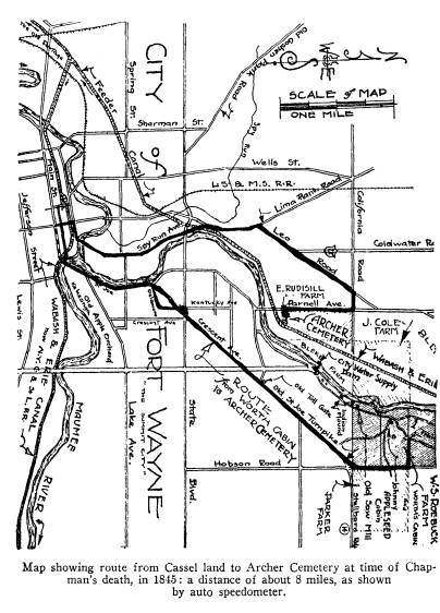
The Archer Burying Ground, 1845
This cemetery is located in Section 25
of Washington Town-
ship on a sandy knoll bordering on the
feeder canal which was
completed in 1835. There was no approach
to this knoll except
by passing over lowlands infested by
malaria and mosquitoes.
The first burial was in 1838. The only
bridge crossing the St.
Joseph River was at Cedarville, about
seven miles north of the
spring on the Cassel-Roebuck land.
Another crossing was a
bridge at the foot of Main Street in
Fort Wayne just below
where the St. Joseph and St. Marys join
and form the Maumee.
This route from the spring on the Cassel-Roebuck land to
the
Archer Cemetery would be a distance of
eight or nine miles. (See
map.)
In March the snows melt, the ice breaks up, and the
streams overflow--more so in 1845 than
today.5
In our discovery of the old trail and
the location of the
Indian houses on this farm and along the
St. Joe River for
about two miles, we have not succeeded
in finding an Indian
burying ground. I reckon the Indians did
not take their dead
across the river and the canal to bury
them where the Archer
Cemetery is located. Are we to believe
that the Johnny Apple-
seed funeral party would be interested
in such a trip? Not when
there was a burying ground near the old
spring where he died.
A Funeral Cortege, March, 1845
The following story was related to me
many times by my
father, born in 1813, in Perry County,
Ohio: Someone had stolen
the clapboard roof off the sugar camp.
Perry Roebuck, father's
youngest brother, boiled sugar water all
night in the rain. He
took lung fever and died. The St. Marys
was on a rampage,
its waters spreading over hundreds of
acres. As there seemed
to be no place suitable for burial in
the neighborhood, the family
4 Cf. A. K. Hofer, C. E., of Fort Wayne, Indiana, Survey and
Topographical
Map of the Cassel-Roebuck Land.
5 There were dams of driftwood in the
rivers which retarded their rush down-
stream, thus causing the ice to pile up
and the water to flow over the entire
valley. These driftwood dams were to be
found all along the river. There was one
in particular, known as the "big drift," bordering upon our own
land which was
one-half mile or more long and remained
there for years.
BURIAL PLACE OF JOHN CHAPMAN 283
decided to bury across the St. Marys,
two miles away, on a sandy
ridge. A coffin, made of rough lumber by
the family and neigh-
bors, was taken to the funeral in the
farm wagon. Before they
had gone far along the winding wagon
trail the coffin was placed
across the top of the wagon box to keep
it out of the water. On
arriving at the crossing place, they
found the bridge had floated
away. The funeral party secured a log
canoe, crossed the river,
and carried the coffin a quarter of a
mile to the sandy ridge.6
These incidents are related in order to
present a picture of
the St. Marys River in March. The St.
Joseph River could have
been little different since it joins the
St. Marys at Fort Wayne.
Richard Worth
Richard Worth lived at the spring on the
Henry Cassel land.
Mr. Worth was a householder and the head
of a family, which is
indicated by the fact that he qualified
for service on the petit jury,
as it is recorded in the Allen County
Commissioner's Records.
Book B, page 1, that during the
January, 1839, term, he was
allowed the sum of $6.25 for 5 days on
the petit jury. It is fur-
ther recorded in the foregoing volume on
page 277, that Richard
Worth was allowed the sum of $1.50 for
"marking,--assisting
surveyor in surveying--road."
Valuable information was obtained
from
the old ledger of the Hamilton-Taber firm, pioneer mer-
chants of the City of Fort Wayne. During
the period from 1836
to 1839, many entries were made in
Ledger C, indicating that
Richard Worth made many purchases, and
when the hooks were
closed in 1848, he owed a balance of
$1.61, with the following
notation on his account, "Bill off,
dead and insolvent." At various
places in his account, Mr. Worth was
credited for timber furnished
to Hamilton and Taber; also he purchased
steel, a line and spool.
Richard Worth must have died between
1845 and 1848.
In the issue of the Fort Wayne Sentinel,
September 17, 1842,
6 On this sandy ridge once stood the
Shawnee Indian village of Old Town.
Near it were two magnificent springs
about 1/2 mile apart. The north one flowed into
Old Town Run and ran to the west; the
south one forming a meandering stream
to the St. Marys. This beautiful place
was the home of Louis Godfrey. Godfrey
sold to Ruel Roebuck, my grandfather, in
1826 a section of his reservation which
was composed of six sections. The
section sold included the village. He then sold
the rest of his holdings and went to
live with his brother, Francis Godfrey, chief of
the Miamis, who lived on the
Mississinewa about three miles from its confluence
with the Wabash.
284
OHIO ARCHAEOLOGICAL AND HISTORICAL
QUARTERLY
Richard Worth was listed a member of a
committee to meet at the
Sentinel office on Saturday, September 24, at 3 p.m., to
consider
the call from the State Central
Committee for a State convention.
David Worth
David Worth was among the number drawn
for the Septem-
ber term, 1836, of the Circuit Court,
which is recorded on page
315, Book A, Allen County Commissioner's
Records. David Worth
also made purchases from the
Hamilton-Taber firm, from 1836
up until his account was paid in full,
October 29, 1838. Among
the items entered in his account, were
two axes at $2.50 each, and
a trace chain. His account was credited
for timber furnished to
Hamilton and Taber. A credit of $5.57
was given to the account
of David Worth, "by Father,"
evidently Richard Worth.
The claim of $8.75 against the estate of
John Chapman, al-
though not assigned by Richard Worth,
was paid by Randall to
a William Worth. The correct date for
the payment (April 22,
1855) by him for the above amount and
the reason no doubt for
Randall paying the same to William
Worth, and taking his receipt
therefor, was because William Worth was
a son of Richard
Worth, and that Richard Worth was dead
by that time.
A Grave Marker--The Stone Bust.
Beginning at a water valve on the south
side of the reservoir
on the hill, measuring 841 feet directly
west, then 249 feet directly
north. This point is on top of a knoll
where the stone bust was
plowed up in 1907, or 1908. At this
point a spruce tree is standing.
It was set at that place in 1937 to mark
the spot. All those telling
about the burying ground below the hill
have been more or less
confused about the exact location of
this cemetery. This is to be
expected. Woods have been cleared away,
trees here and there
have been cut down, and fences have been
taken away. The old
lane from the barn to the river is not
there, and moreover, the
roads have been changed, and the frog
ponds and boggy places
have been ditched. The crests of the
hills have been leveled and
some removed entirely. Through all this
change, the place where
the bust was found fixes the location of
the burying ground.