Ohio History Journal
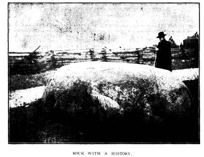
A ROCK WITH A
HISTORY.
BASIL MEEK, FREMONT.
The accompanying cut represents a large
granitic boulder,
believed to be the largest in Sandusky
County, and which pos-
sesses local historic associations
worthy to be published for pres-
ervation with other interesting facts
connected with the early his-
tory of the Sandusky river region.
It is located in the north and south
road on the line dividing
Sections 14 and 15 between the farms of
W. J. Havens and Hugh
Havens in Jackson township, 7 miles
south-west from the City of
Fremont.
There is a general, and what seems to be
an undisputed,
tradition, that during his campaigns in
the Sandusky and Mau-
mee river valleys, in the War of 1812, Gen. William
Henry Har-
rison, with his military staff, at one
time dined upon this boulder
as a table.
There was an Indian trail leading
from Lower Sandusky
(Fremont), through what is now Spiegel
Grove, the grounds of
the late President R. B. Hayes, passing
thence west of the San-
dusky river, in a southwesterly
direction and intersecting at a
point not far east of this rock a
similar one from the site of Fort
Seneca, and thus becoming united into
one trail, which passed
near the rock in a northwesterly
direction to Fort Meigs, on the
Maumee river.
This trail became known as the "
Harrison trail," because in
his military movements between Lower
Sandusky and Fort Sen-
eca on the Sandusky river, and Fort
Meigs on the Maumee, Gen.
Harrison made use of it as a military
road. While passing along
the same, according to tradition, he and
his military family
partook of the repast mentioned upon
this substantial table in the
then wilderness.
The Messrs. Havens who have owned these
farms for fifty
years, well remember traces of this
trail and pointed out to the
writer the ground along which it ran.
They remember and speak
of it as the " Harrison
trail."
(328)
|
A Rock with a History. 329 In the field notes of the government survey, 1820, of said sections 14 and 15, it is mentioned as the " Road to Fort Meigs," and its location shown to be near the spot where the boulder lies. In size, the boulder is 12 feet in length, with a slightly con- vex top surface containing 80 square feet; its circumference at the ground is 37 feet, and near the top 32 feet; it rises 3 1-2 feet above ground, and as nearly as can be ascertained, lies embedded in the earth about the same number of feet it rises above; which would make it contain 500 cubic feet and weigh 40 tons. |
|
|
|
It has been regarded by some as merely an obstruction in the highway, and occasional threats have been made to destroy it, but thus far the better sentiment favoring its preservation, has prevailed. If this article shall aid in promoting still further this senti- ment, and result in the preservation of this historic rock which may appropriately be named " Harrison Rock," and which is suggested as a name for it, the object of the writer will have been accomplished. |