Ohio History Journal
|
INDIAN LAND CESSIONS IN OHIO.
BY S. S. KNABENSHUE. Ever since the civilized nations of the world began to occupy lands peopled by savages, they have based their claims upon the right of discovery, followed by occupation. This principle has been judicially affirmed by the United States Supreme Court, which declared "that discovery gave an exclusive right to extin- guish the Indian title of occupancy, either by purchase or con- quest," and also to sovereignty. (Johnson and Graham's lessee, v. McIntosh, 8 Wheaton, p. 543 et seq. Decided in 1823). The title to the soil of Ohio was obtained by treaties of cession from the tribes. In the two maps accompanying this arti- |
|
|
|
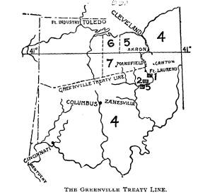
cle, all the principal cessions and Indian reserves are shown. The first treaty affecting Ohio lands was made with the Wyandots, Delawares, Chippewas and Ottawas in 1785, which defined the (249) |
250 Ohio Arch. and His. Society Publications.
boundaries of the Indian tribes, and
ceded certain tracts to the
whites. This was followed by another in
1786 with the Shaw-
nees. But neither of these was ever
carried into effect because
of continued warfare on the frontier
between Indians and whites.
Under them, however, Congress made three
grants September
3, 1788, each of 4,000 acres, to
Christian Indians in Ohio. These
were at the Moravian missions of
Shoenbrun, Gnadenhutten and
Salem, on the Muskingum. They are marked
1, 2 and 3 on the
small map. They were repurchased by the
government in 1823.
It was not until Gen. Anthony Wayne's
expedition, in 1794,
crushed the power of the Indians in Ohio
at the decisive battle of
Fallen Timbers on the Maumee, some dozen
miles above Toledo,
that the United States obtained cession
of Ohio lands which the
tribes recognized. This treaty, the
fruit of Wayne's victory, was
made at Greenville, Ohio, August 3,
1795, with the Wyandots,
Delawares, Shawnees, Ottawas, Chippewas,
Pottawatomies, Mi-
amis, Eel Rivers, Weas, Kickapoos,
Piankeshaws and Kaskas-
kias.
By this treaty the Indians gave up to
the United States all
lands lying east and south of the
following boundary, known as
the Greenville Treaty Line:" From
the mouth of the Cuya-
hoga river up that stream to the Portage
between it and the Tus-
carawas branch of the Muskingum; thence
down the Tuscarawas
to the crossing-place above Fort
Laurens; thence westerly to a
fork of that branch of the Great Miami
river at or near which
stood Loramie's store; thence westerly
to Fort Recovery; thence
southwesterly in a direct line to the
Ohio river opposite the mouth
of the Kentucky. The line is shown on
the smaller map, and the
area ceded is marked 4.
The Indians thus granted nearly
two-thirds of Ohio's entire
area, embracing the eastern and southern
portions, and a small
triangular portion of southeastern
Indiana. By the same treaty,
the Indians ceded to the United States a
number of smaller tracts
of land within the general limits of the
territory reserved to them-
selves in Ohio, Indiana and Michigan.
The following is a list
of these cessions in Ohio, the number
preceding each indicating
its location on the large map:
|
Indian Land Cessions in Ohio. 251 8. Six miles square at or near Loramie's store. 9. Two miles square at the head of navigable water on St. Mary's river, near Girty's town. |
|
|
|
10. Six miles square at the head of navigable water on the Auglaize river. 11. Six miles square at the confluence of the Auglaize and Maumee, at Ft. Defiance. This was surveyed in 1805. 12. Twelve miles square at the British Fort Miami, at the foot of the rapids of the Maumee. This was surveyed in Decem- |
252 Ohio
Arch. and His. Society Publications.
ber, 1805; subdivided and sold under act
of Congress of April,
27, 1816.
13. Six miles square at the mouth of the
Maumee. Sur-
veyed in 1806 by Ewing under act of
Congress of March 3, 1805.
This embraced all of the area on which
Toledo now stands, and
extended north just across the Michigan
line.
Two miles square on Sandusky bay, where
a fort formerly
stood. This was found to be within the
limits of the Firelands,
and hence was never separately surveyed.
14. Two miles square at the lower rapids
of the Sandusky
river, at Ft. Stephenson, where Fremont
now stands. Surveyed
by Ewing in 1807; subdivided into town
lots and sold under act
of Congress of April 27, 1816.
The next cession in importance was that
made by the treaty
of July 4, 1805, made at Fort
Industry, where Toledo now stands.
The tribes participating were the
Wyandots, Ottawas, Chippewas,
Munsees, Delawares, Shawnees and
Pottawatomies.
This treaty defined the boundary between
these Indians and
the United States to be a meridian line
drawn north and south
120 miles
due west of the Pennsylvania line, and extending from
Lake Erie south to the Greenville treaty
line. This embraced
three tracts, all shown on the small
map. The one bordering on
Lake Erie west of the Cuyahoga, numbered
5 on the small map,
is a part of the Western Reserve; the
tract next west, numbered
6, is the Firelands, which are really a
part of the Reserve; and
third, the tract south of these two,
numbered 7, between the 41st
parallel and the Greenville treaty line.
The Western Reserve of Connecticut
occupied the north-
eastern corner of the state. It was
bounded on the north by Lake
Erie, on the east by Pennsylvania, on
the south by the 41st parallel
of latitude, and on the west by the
present east line of Seneca
and Sandusky counties. In 1792 the
Connecticut legislature
granted 500,000 acres off the west end
of the Reserve to such of
her citizens as had suffered by British
depredations in the Revo-
lution -the burning of Groton and New
Britain especially. On
this account this tract is called the
Firelands.
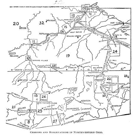
On November 17, 1807, a treaty was
made at Detroit with
the Ottawas, Chippewas, Wyandots and
Pottawatomies, by which
Indian Land Cessions in Ohio. 253
they ceded to the United States a large
area in southern Michigan,
and including, in Ohio, all lands lying
north and east of a line
beginning at the mouth of the Maumee,
and running up that
stream to the mouth of the Auglaize,
thence due north. See No.
32 on the large map. From this area,
however, the Indians re-
served the following tracts, the numbers
referring to positions
on the large map:
15. Six miles square on the Maumee,
above Roche de Boeuf,
"to include the village where
Tondaganie (or the Dog) now lives.'
This reserve was ceded to the United
States August 30, 1831
The name of the Chief Tondoganie, the
Dog, (which is speller
several different ways in the documents)
is perpetuated in the
name of the village of Tontogany, Wood
county, which stands a
few miles east of the site of the Indian
village.
16. Three miles square on the Maumee,
above the twelve
miles square ceded by the treaty of
Greenville, "including what is
called Presque Isle," which is the
hill immediately south of and
overlooking the battlefield of Fallen
Timbers. This reserve was,
however, located at Wolf Rapids, as
Presque Isle was found to
be within the twelve-mile square
reserve, at the foot of the Rapids
of the Maumee, ceded to the United
States by the treaty of Green-
ville. This reserve was ceded to the
United States by treaty of
August 30, 1831.
17. Four miles square on Maumee bay,
"including the vil-
lages where Meshkemau and Waugau
live." This reserve was
ceded to the United States by treaty of
February 18, 1833. It em-
braced the lands from Toledo to and
across the Ottawa river, and a
part of Michigan on the other side of
that stream, on the western
shore of Maumee bay.
At Brownstown, Mich., a treaty was made,
on November 25,
1808, with the Chippewas, Ottawas,
Pottawatomies, Wyandots
and Shawnees, ceding to the United
States a tract of land for a
road, 120 feet wide, from the foot of
Maumee Rapids (Perrys-
burg), to the western line of the
Western Reserve; and all the
land within one mile of said road on
each side, that settlements
might be established along it. It is
numbered 18 on the large map.
They also ceded a strip 120 feet wide, for
a roadway only, settle-
254 Ohio Arch. and His.
Society Publications.
ments being barred, from Fremont south
to the Greenville boun-
dary line. This road followed up the
Sandusky river, passing just
west of Tiffin, through Upper Sandusky
and Marion, and reach-
ing the Greenville treaty line about
half way between the latter
place and Delaware.
These roads gave free access between the
twelve-mile square
cession at the foot of the Maumee
Rapids, and the lands already
in possession of the whites east and
south of the Indian tract.
On September 29, 1817, a treaty was made at the foot of the
Rapids of the Maumee, with several
Indian tribes, by which the
Wyandots ceded all the land in Ohio west
of the line established
by the Fort Industry treaty, except
certain reserves hereinafter
stated; and the Pottawatomies, Ottawas
and Chippewas ceded the
remaining Indian lands in the
northwestern corner of the state,
north of the Maumee, and west of the
Detroit treaty line - num-
bered 20 on the large map. This
extinguished the Indian title to
all lands in Ohio but a small area south
of the St. Mary's river
and north of the Greenville treaty line,
marked 21 on the large
map - excepting the following named
small reserved tracts. The
numbers of the list below correspond
with those on the map:
22. To nine chiefs, Doanquod, Howoner, Rontondee, Tau-
yau, Rontayau, Dawatont, Manocue,
Tauyaudautauson and
Hadaunwaugh, a tract twelve miles square
at Upper Sandusky,
its center being Fort Ferree. This was
ceded to the United States
by treaty March 17, 1842.
23. To the same, for the use of the
tribe, one mile square in
a cranberry swamp on Broken Sword creek.
This was ceded to
the United States April 23, 1836.
24. A tract of 30,000 acres for the
Seneca tribe on the San-
dusky river. Ceded to United States
February 28, 1831.
25. A tract to the Shawnees at Wapakoneta, ten miles
square, the center being the
council-house at that Indian village.
Ceded to United States August 8, 1831.
26. A tract adjoining the above, on Hog
creek, of twenty-
five square miles. Ceded to United
States August 8, 1831.
27. A tract of forty-eight square miles to the Shawnees at
Lewistown. Ceded to the United States
July 20, 1831.
Indian Land Cessions in Ohio. 255
28. For the use of the Ottawas, five
miles square on Blanch-
ard's Fork of the Auglaize. Ceded to
United States August
30, 1831.
29. For the use of the Ottawas, three
miles square, including
Oquanoxa's village. Ceded to the United
States August 30, 1831.
30. To the Delawares, nine square miles
adjoining the re-
serve to the Wyandots on Sandusky river.
Ceded to the United
States August 3, 1829.
31. To the Ottawas, thirty-four square
miles on the south
side of the Maumee, including McCarthy's
village. Ceded to the
United States February 18, 1833. This
included all of East
Toledo and Presque Isle.
There were also fourteen small tracts
granted to certain in-
dividuals, aggregating 9,480 acres.
A supplementary treaty to the above was
made at St. Mary's,
on September 17, 1818. By it there were
additions made to seven
enumerated reserves. These lands were
ceded to the United
States by the treaties of July 2 and
August 8, 1831, January 19,
1832, April 23, 1836, and March
17, 1842.
The last treaty that concerned Ohio
lands was made at St.
Mary's, on October 6, 1818, by which the
Miamis ceded lands in
Indiana and Ohio-the area in the latter
being the small tract
between the Greenville treaty line and St.
Mary's river, marked
No. 21 on the large map. This was the last tract in Ohio
held
by the Indians under the claim of
original possession. Nothing
was left except the reserves. These were
gradually ceded to the
United States, at the dates noted above
where each is mentioned.
The last was the Wyandot reserve at
Upper Sandusky, which was
ceded on March 17, 1842.