Ohio History Journal
SEVEN PREHISTORIC SITES IN NORTHERN OHIO
By EMERSON
F. GREENMAN
Description of the Sites.
In the summer of 1929, during
excavation of the Reeve vil-
lage site near Willoughby,1 other
sites were located, mapped and
examined. Some were found by the use of
William C. Mills'
Archaeological Atlas of Ohio (Columbus, Ohio, 1914), while
others have not been mentioned
heretofore in archaeological lit-
erature. Four of these sites are on the
tops of hills, and the oc-
cupied areas of two of these are
fortified by transverse walls with
outer ditches. One is a double-walled
circular inclosure and
another, near Lorain, is a large
semi-circular inclosure at the
edge of the bluff of Black River. The
seventh site, near Paines-
ville, at the top of a bluff of Grand
River, is uninclosed.
Only one of these sites has been totally
destroyed, and no
excavations were made. This was an oval
earthwork with ac-
companying ditch, outlining the top of a
hill on the edge of the
city of Conneaut, Ashtabula County. This
inclosure was first de-
scribed in Ancient Monuments of the
Mississippi Valley (Cincin-
nati, 1848), by Ephraim George Squier
and Edwin Hamilton
Davis, on page 38. The soil of this
hilltop is light and sandy,
and no evidences of occupation were
observed at the surface. At
present this hilltop is the site of a
vineyard.
The names given herein to these seven
sites are taken either
from the name of the nearest town, or
from that of the family
owning the site. The field staff was made
up of the writer,
1 Emerson F. Greenman, "Excavation
of the Reeve Village Site, Lake County,
Ohio," in Ohio State Archaeological
and Historical Society Quarterly (Columbus, Ohio,
1887-), XLIV (1935), 3-64.
(220)

|
|||
|

222 OHIO ARCHAEOLOGICAL AND HISTORICAL QUARTERLY

|
|
separated only by a shallow trough three or four feet wide, the bottom of which is about a foot above the general level of the ground. There were various depressions in both walls, and one or more may originally have been gateways, but which ones were actually so used cannot now be determined. This inclosure lies on a flat elevation the surface of which is from fifteen to twenty feet above the level of a swamp of some seventy acres. Signs of occupation, as revealed by excavation lasting one week, were rather sparse. Black soil, intermixed with ashes and animal bones, covered the entire interior of the inclosure to a depth varying from six inches to a foot. Artifacts were found in this soil, and in irregular pits from one to three feet in depth which contained no observable strata. A trench through both walls on the east side brought to light in the outer wall two vertical pointed areas of dark soil which were taken to be the remains of posts forming part of a log stockade. The tops of these post-molds began two feet beneath the surface of the wall, one extending downward two feet, and the other a foot and a half. The posts indicated by these molds were about seven inches in diameter, and over most of their length were not more than two inches apart, providing they were in erect positions. No flint projectile points were found on this site, and arti- facts of all types were scarce, indicating a rather limited occupa- tion. Halves of five bird-bone beads and two entire specimens range in length from two to three and one-half centimeters. Three are shown in Figure 2, A. The one at the left has nine notches. Five deer antler-tips show use, probably as flint-chipping tools as the tips are blunt or polished, and the bases are not perforated. One is shown in Figure 2, B. C is another type of flint-chipping tool with both ends missing. Only one entire bone awl is repre- sented in this collection. It is a section of the leg-bone of a deer, and is split longitudinally (Figure 2, D.). E and F have polished surfaces, but the points are missing. Three other pieces of bone show various signs of use. One has a polished surface, another is part of the leg-bone of a bird which has been cut squarely off |
PREHISTORIC SITES IN NORTHERN OHIO 223

|
|
at one end, and the third has a narrow incised line near one end. G is the tip of a chisel, or perhaps a flint-chipping tool, of antler. In Figure 10, G is a sandstone discoidal which was found in a field about 500 feet to the north of the inclosure, on the surface. It may not belong to Boice Fort. In the thirty-six potsherds found at least three separate ves- sels are represented. In Figure 3, A is a section of the rim of a shell-tempered pot with notches or narrow scallops in the lip, each scallop having three grooves parallel to the sides of the pot (Fig- ure 7, 0; cross-section, Figure 7, A.). Nine sherds, including this rim-fragment, apparently belong to the same pot. The sherd illustrated is 9mm. thick, and the thinnest of the remainder is 4mm. The paste is nearly black on the outer surface and light brown on the inner. The chief feature of this vessel is the por- ousness of the paste. There are cavities of various shapes and sizes up to 4mm. in diameter on both surfaces, and they show up also in the broken edges. The tempering is fine and evenly dis- tributed. The outer surface is roughened by the vertical marks of a cord-wrapped paddle, the impressions extending to the edge of the lip. Another vessel, grit-tempered, is represented by two sherds. Figure 3, B, is a portion of the rim. The lip has a low scallop with five notches extending a short distance down the inner sur- face at the scallop. On the outer surface similar notches extend down the same distance on each side of the scallop. The outer surface of these sherds bear irregular paddle marks. The cross- section of the illustrated rim-sherd is shown as B in Figure 7. The third vessel is also grit-tempered, and is represented by six body-sherds. The paste is light brown throughout, and on both surfaces. No sherd is more than 4.5mm. thick, and the outer surfaces are roughened by shallow paddle marks, in lines about 2mm. wide, roughly parallel. The remaining sherds are grit-tem- pered. One grit-tempered body sherd (Figure 3, C.) has lightly in- cised horizontal lines above a row of punctate marks, and a diag- onal paddle mark. |
224
OHIO ARCHAEOLOGICAL AND HISTORICAL QUARTERLY
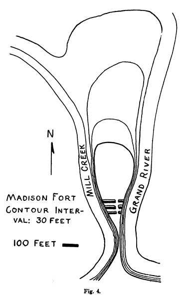
Madison Fort. In Lake County a prehistoric hilltop forti-
fication of an unusual type was
discovered about four miles south
of the village of Madison. It is
admirably situated between Grand
River and Mill Creek, and is approached
by walking along a ridge
separating these two streams where they
come to within about 200
feet of one another (Figure 4.). The top
of this ridge is ninety
feet above the water-level of the
streams, and the path is but
three feet in width (See illustration
facing page 220).
About 150 feet to the north of the
narrowest part of this
ridge is the southernmost of the three
transverse walls. Probably
the remains of stockades with earth
piled at the bases of the ver-
tical logs, these walls average three
feet in height above the gen-
eral level, and a ditch borders each one
on the north. Presumably
the area, less than an acre in extent,
lying between the narrow
part of the ridge and the northernmost
wall, was the part occu-
pied, and it was here that the only
artifact, a small fragment of
undecorated grit-tempered pottery, was
found a few inches below
the surface. The soil is light in color
and scarcely a foot thick,
with the top of the limestone directly
beneath.
The walls are from fifty to eighty feet
long, and the meas-
urement from the bottom of the ditch to
the top of the wall is
not more than five feet in any instance.
Three depressions at the
same point in each wall, corresponding
to intermissions of the
ditch, provide a level passage from the
inner to the outer wall
(Figure 5.).
Painesville Site. Inquiries near Painesville brought out the
existence of a site about four miles
east of that city, on the north
bank of Grand River, where the bluff is
nearly perpendicular and
about a hundred feet high. In the work
of a forenoon a large
section of a vessel and one bone bead
were found. Reports of a
recent fill raised the suspicion that
these objects had been brought
to the site from elsewhere. No other
signs of aboriginal occupa-
tion were found.
The sherd (Figure 3, D.) is that of a
vessel eight or ten
inches in diameter at the top. It is
shell-tempered, and the paste
is finely-textured. One broken edge
shows a laminated structure
|
PREHISTORIC SITES IN NORTHERN OHIO 225 |
|
|
226 OHIO ARCHAEOLOGICAL AND HISTORICAL QUARTERLY

|
|
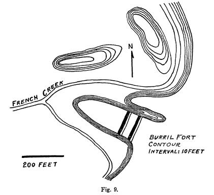
with outer and inner layers of light brown from 2 to 3mm. thick, and a central layer of black from 3 to 5mm. thick. The fragments of ground shell are not of uniform thickness. This sherd is a portion of the rim which has a wide, low scallop. There are cir- cular depressions in the lip from 4 to 6mm. in diameter and from 3 to 5mm. apart. The outer surface, which is dark brown, bears the vertical marks of a cord-wrapped paddle, from the lip down- ward. At the shoulder this paddle mark has been smoothed over in several horizontal uneven streaks. In cross-section (Figure 7, C.) the thickest point is at the shoulder, where this measure- ment is 10mm. The bone bead (Figure 14, F.) was found eighteen inches from the sherd, and is of a type not found on any of the other sites herein described. Burrill Fort. This fortified promontory is in Sheffield town- ship, Lorain County, on French Creek one-quarter of a mile from its entry into Black River. It is described by Squier and Davis in Ancient Monuments of the Mississippi Valley on page 39. The promontory (Figure 9.) is 348 feet long and 123 feet wide, and projects into the valley flat of French Creek where the stream divides into two branches. The surface is level, and about forty- seven feet above the beds of the two branches, which are about twelve feet wide. Two walls with outer ditches traverse the neck of the promontory on the southeast. They are 128 feet long, and the distance from the inner edge of the outer wall to the edge of the ditch adjoining the inner wall is thirty-seven feet. There are several depressions in each wall, but none was definite enough to be described as a gateway. The walls are eighteen feet wide and from one and one-half to two feet in height. Signs of occupation were not profuse. Excavations lasting a week disclosed several depressions in the surface, irregular in outline and from two to three feet in depth. These were filled with dark gray soil which contained artifacts of various types, animal bones, and a small amount of charcoal and ashes. No strata were observed. |

|
|

|
228 OHIO ARCHAEOLOGICAL AND HISTORICAL QUARTERLY
section T. The latter is fine-grained sandstone, and the surfaces are quite smooth. Only the surfaces of C are polished near the cutting edge. The cross-section of E is rather irregular, but the face opposite that shown tends to flatness. The only hammer- stone found on this site appears at first sight to be a thick pestle, but the base is cupped, and faces and sides each have a roundish pecked area an inch and a half across. The material is sandstone. |
|
|
|
In Figure 10, E is a fragment of a gorget of blueish slate exhibiting part of a countersunk hole. The original thickness cannot be determined, as the face opposite that shown is missing. F is reddish brown ferrous carbonate, 6mm. thick. Both faces are covered with fine lines or scratches at various angles to one another. The remaining stone objects from this site consist of a granite hammerstone with oval outline, and a fragment, also granite, which is apparently the bluntly-pointed end of a celt with a round cross-section. The only bone awl found is shown in Figure 14, A. It is 7.7cm. long, and the blunt end is notched. Representative potsherds from Burrill Fort are shown in Figure 12, A-I. Only a single rim-sherd (A.) is shell-tempered. The paste is gray, and the fragments of shell are of various sizes up to 4mm. across. The cross-section is D, Figure 7. B and C in Figure 12 are grit-tempered, with dark brown paste, and cross- |
|
PREHISTORIC SITES IN NORTHERN OHIO 229
sections are as in Figure 7, E and F, respectively. The cross- sections of eight plain rim-sherds, all grit-tempered, are shown in Figure 7, G-N. All but K have paddle marks on the outer surface. The paste of these sherds is from light to dark brown. Four body sherds show decoration (Figure 12, D-G.). There |
|
|
|
are incised lines on D and E, and the latter also has a row of punctate marks. The parallel lines on F appear to have been pressed in rather than incised. They may constitute a paddle mark rather than a design. The punctate row in G borders a series of rouletted rows. In addition to these decorated sherds there are 166 body sherds, undecorated, and all grit-tempered. The paste is coarse, |
230 OHIO ARCHAEOLOGICAL AND HISTORICAL QUARTERLY

|
|
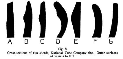
and nearly black, to light reddish brown or gray. The tempering material is coarse and unevenly distributed. These sherds range in thickness from 5 to 14mm. Thirty-one are over 9mm. thick. Inner surfaces are relatively smooth except for the protrusion of particles of tempering material, which is mainly quartz. The outer surfaces are mainly paddle-marked, deep in many cases (Figure 12, H.) and in parallel lines, or sometimes in lines crossing one another at angles (Figure 12, I.). On one sherd the paddle marks cross to form a diamond-shaped pattern, and a few show impression with a cord-wrapped paddle. One sherd has a countersunk hole in the edge. National Tube Company Site. Three-quarters of a mile west of Burrill Fort is an uninclosed village site on a hill the level top of which is thirty-five feet above the level of the water in Black River, in Sheffield township, on land belonging to the National Tube Company. This hill, formerly separated from the mainland by a swamp which probably was an old channel of Black River, is now an island formed by the dredging of this swamp. The area of occupation was confined to the highest part of this artificially-formed island, and comprises about one acre. The bluff is nearly perpendicular on the east and south, and slopes gently to the water's edge on the remaining borders. The soil is about a foot thick, with the weathered and broken surface of the limestone directly beneath. One day was spent in excavation. Projectile points and other flint types are shown in Figure 13, A-E. Two scrapers of the "keeled," or "thumb-nail" type are shown as B (longitudinal cross-sections, Figure 7, P.). The three leaf-shaped forms to the right in row C are probably scrapers, as the longitudinal cross-section is that in Q, Figure 7. The two at the right in row D are six and ten millimeters thick, while the other three are thin and well made. The three forms E were probably used as punches or drills. In addition to the illustrated specimens there are seven broken pieces indicating triangular unnotched forms only one of which is as thin as five millimeters. Another specimen is a "blank" of light-colored chert, rectangular in outline, 4cm. long and 14cm. thick. |

|
|
PREHISTORIC SITES IN NORTHERN OHIO 231
Of bone artifacts there are but six, the two awls shown in Figure 14, B, C, and four bird-bone beads, one of which is shown as E, Figure 14. Grit-tempered potsherds have a slight majority over those tempered with shell. The paste of this series of sherds is quite similar to that of the general run of potsherds from the sites that have been previously described, with the exception of seven rim- sherds representing two pots. Two of these are shown in Figure 15, A, B. The surfaces of both are of red material, slightly gritty, but this red does not show on outer surfaces except where there are breaks, as there is a thin coating of black, perhaps re- sulting from the stains of use and handling. A has a laminated structure, with a central layer of black paste 3 to 4mm. thick enclosed in outer layers of the red paste with an average thick- ness of 2mm. Both have the cross-section, B, Figure 8. The complete range in type of decoration is shown in Figure 15. A-E and H have the crimped pattern, consisting of depres- sions in a ridge of clay added to the rim just below the lip. F is without decoration, and has a cross-section as shown in Figure 8, A. G has a band of lightly-incised horizontal lines and deeper vertical punctate lines, with a cross-section as in Figure 8, G. In J there is a similar band of parallel lines, slightly deeper. I, another body sherd, shows two groups of parallel lines at an oblique angle. A and B are grit-tempered, and the rest of the sherds in Figure 15 are tempered with shell.2 None of these rim-sherds exhibits the paddle mark, but it is found on most of the body sherds. Eight rim sherds not illustrated exhibit the same features as A and B in Figure 15, and while they do not match at the edges, they may belong to one or the other of those two vessels. Three have notched lips, and the lips of three others are without that feature. The inner surfaces of the remaining two are missing, and the paste is gray. The lips are plain. One more sherd from this site is grit-tempered, with a cross-section as in Figure 8, F. The paste is dark gray, and the outer surface is black.
2 Cross-sections of sherds in Figure 15 not already given are as follows: C, as in B, Figure 8; D, as in C, Figure 8; E, as in E, Figure 8; H, as in D, Figure 8. |
232 OHIO ARCHAEOLOGICAL AND HISTORICAL QUARTERLY

|
|
White Fort. In Elyria township, Lorain County, three or four miles south of the two sites just described, there was for- merly a large semi-circular earthwork on the farm of Robert White. The open side bordered the edge of a perpendicular bluff the top of which is seventy-five feet above the water-level of Black River. Only about seventy-five feet of the wall, in a wood- lot, have been preserved. The remaining portion was in what is now a cultivated field, and can be distinguished only as a light band of color in the soil. There is a shallow ditch on the west side of the portion of the wall in the woodlot. The wall here is from one to two feet in height and about ten feet wide. At the edge of the bluff, within the area fortified, there is a spring. A single day was devoted to excavation, in the wall and in the inclosed area. No evidence of occupation was found other than artifacts and animal bones. The only flint points found are shown in Figure 13, G and F. G is black, and at the base, which is missing, the specimen is 7mm. thick. F is light gray, and of a type not found on the other sites herein described. Of bone artifacts there are only the split animal-bone awl in Figure 14, D, and a small bird-bone bead. Half of a round hammerstone of loosely-textured granite, with a pit on one side, was found at a depth of six inches near the inner edge of the wall. The twelve fragments of pottery, all body sherds, are grit- tempered. The paste is from dark to light brown, and tempering particles are coarse. In Figure 3, E and F show the only two decorated sherds found. The lines on E are slightly waved. The design on F is punctate, possibly by the roulette method.
Conclusion. An examination of the list of traits in the table (page 233.) makes it apparent that at least four of these sites, Burrill, Boice, Madison, and the uninclosed hilltop site on the property of the National Tube Company, are related. With the exception of rouletted patterns on potsherds, antler-tip flint-chippers and dis- coidal stones, all the artifacts in this list were found on the Reeve village site near Willoughby, and this site was tentatively attrib- |

|
|

234 OHIO ARCHAEOLOGICAL AND HISTORICAL QUARTERLY

|
|
uted to the Iroquois.3 Among the chief features providing the basis for this identification are beads and awls of bone, triangular, leaf-shaped and truncated flint points, roughly flaked celts, pot- tery with the crimped pattern and incised horizontal and diagonal lines, and shell tempering. Two or more of these traits are found at Burrill and Boice Forts, and at the National Tube Company site, and in the absence of artifacts representative of other cul- tures these are sufficient to ally these sites with the Reeve village near Willoughby. As for Madison Fort, its similarity to Burrill Fort, with transverse walls and ditches, indicates the probability of a similarity between the builders of the two sites. Burrill Fort is brought very close to the Reeve site by the presence, in addition to the traits above mentioned, of notched bone beads, notched and stemmed projectile points, keeled scrapers, slate gorgets, and the scratched stone of ferrous car- bonate. A piece of the latter is shown in Figure 19 of the Reeve report, and is identified in the Appendix as slate. But the two specimens from these sites are of the same shade of red on the outer surface, and both bear irregular scratches. A further re- semblance of Boice Fort to the Reeve site is seen in the presence of the bone flint-chipper shown in Figure 2, C, and the potsherd with grooves in the scallops (Figure 3, A; compare this with B in Figure 27 of the Reeve report). The presence of the roulette pattern at Burrill and White Forts ties the two more closely together, and suggests the influence of "Algonkian" or Woodland types of pottery decora- tion, which become more frequent as one proceeds westward in northern Ohio. White Fort, in fact, may have been the site of an "Algonkian" occupation. Burrill, Boice and Madison Forts, and the National Tube Company site, may be classified along with the Reeve site4 in the Middle Mississippi phase of the Mississippi basic culture. White Fort and the Painesville site appear to belong to the Woodland phase, although the artifacts from these two are so few that posi-
3 Greenman, "Excavation of the Reeve Village Site," loc. cit., 9. 4 Ibid., 8-9. |
PREHISTORIC SITES IN NORTHERN OHIO 235

|
|
tive identification cannot be made. On the evidence available at present the Conneaut oval hilltop fortification might be assigned to either one. Catalog. Boice Fort. Accession Number 1014. 1. 7 bird-bone beads, two whole and five fragmentary. Three shown in Figure 2, A. 2. 36 fragments of pottery. 3. 1 sandstone discoidal, found about 500 feet north of the inclosure. Figure 10, G. 4. 19 animal and bird bones. 5. 5 deer antler prongs, worked. 3-8cm. long. One shown in Figure 2, B. 6. 2 pieces worked bone, one polished, one with an in- cised line near end. 7. 1 bone flint-chipping tool, 6.5cm. long, ends missing. Figure 2, C. 8. 3 bone awls, two of bird-bone (Figure 2, E, F.), and one of animal bone, split (Figure 2, D.). 9. 1 end of an antler chisel or flint-chipping tool (Figure 2, G.). Painesville Site. Accession Number 1019. 1. 1 fragment of the rim of a vessel. Figure 3, D. 2. 1 bone bead, animal bone (Figure 14, F.). 9mm. long, 12mm. outside diameter. Walls 2-3mm. thick. Burrill Fort. Accession Number 1016. 1. 3 notched projectile points (Figure 10, C.). 2. 4 triangular unnotched projectile points (Figure 10, A.). 3. 1 stemmed scraper (Figure 10, D, right.). 4. 1 keeled scraper (Figure 10, D, left.). 5. 2 ornamental forms, one slate gorget (Figure 10, E.), and a piece of red stone bearing scratches (Figure 10, F.). 6. 1 bone awl, notched at blunt end (Figure 14, A.). |
236 OHIO ARCHAEOLOGICAL AND HISTORICAL
QUARTERLY
7. 1 pitted hammerstone, sandstone, shaped
like a "bell"
pestle (Figure 11, F.).
8. 1 granite pitted hammerstone.
9. 1 small celt, smooth surface (Figure 11,
C.).
10. 3 celts, and the end of another which is
round in
cross-section. Three
are shown in Figure 11, A,
D, E.
11. 1 fragment
of a celt, sandstone (Figure 11, B.).
12. 173 potsherds.
13. 85 fragments of animal, fish and bird bones.
14. 1 flint blank, 3 by 3.5cm., 10mm. thick.
15. 5 broken flint points.
16. 4 stemmed points (Figure 10, B.).
National Tube Company
Site. Accession Number 1015.
1. 5 triangular unnotched points, 3.2-4.2cm.
long. Fig-
ure 13, D.).
2. 3 small drills, chert (Figure 13, E.).
3. 1 bone bead, 2.4cm. long (Figure 14,
E.).
4. 7 fragmentary flint points and rough
pieces of flint.
5. 16 rim sherds.
6. 104 body sherds.
7. 21 fragments of
animal, fish and bird bones, and two
mussel shells.
8. 1 turkey leg-bone awl, 8cm. long. Point
missing (Fig-
ure 14, C.).
9. 1 truncated black flint point, 4.1cm. long
(Figure 13,
A.).
10. 2 keeled scrapers, 3.1-4.1cm. long
(Figure 13, B.).
11. 5
leaf-shaped flint points, 2.1-4.6cm. long (Figure 13,
C.).
12. I flint
blank, rectangular, 3.7 by 2.9cm., 15mm. thick.
13. 1 bone awl, Figure 14, B.
PREHISTORIC SITES IN NORTHERN OHIO 237
White Fort. Accession Number 1033.
1. 2 flint projectile points (Figure 13, F, G.).
2. 1 bone
awl, animal bone, split (Figure 14, D.).
3. 1 bone bead, bird bone.
4. 12
fragments of pottery.
5. 3 fragments of mussel shells.
6. 13 fragments of animal bones.