Ohio History Journal
REPORT OF FIELD WORK
CARRIED ON IN THE MUSKINGUM, SCIOTO AND
OHIO VAL-
LEYS DURING THE SEASON OF 1896, BY
WARREN KING
MOOREHEAD, IN CHARGE OF EXPLORATIONS.
PREFACE.
It is interesting to note that as
general archaeology pro-
gresses in the United States, men are
more inclined to confine
their observations to special or limited
areas. A generation ago,
before the Government, the Museums of
our various cities and
the Scientific and Historical Societies
undertook large explora-
tions, it was possible for one observer
to cover the whole of the
American field from the mouth of the St.
Lawrence to Mexico.
Later, as anthropologic science
advanced, one essayed to write of
the Mound Builders, another on the Cliff
Dwellers and yet an-
other upon the antiquities of Central
America. To-day, scientists
have so specialized that volumes may
indeed be written upon the
prehistoric remains of one river
valley. This is the natural out-
come of much study and investigation.
What is true of every
other science is also true of that most
important branch of An-
thropology-prehistoric archaeology. In
the past it was suffi-
cient to briefly describe our mounds and
earthworks, give their
measurements, enlarge upon their
supposed character and pur-
pose, etc. Most of our archaeologists in
this modern age follow
the natural history method, which, by
the way, is by far the
safest and most satisfactory, and study
every little pottery frag-
ment, flint implement, bit of shell or
worked tool as carefully
and persistently as does the
palaeontologist his fossil. With
them, it is not so much the prettiest
and most perfect specimen,
but all the specimens which tell
the story. A mound is explored
by them, not for what it contains, but
because something may
be learned from its examination. The
rude hammer stone*-an
* In this connection, Archaeologist J.
D. McGuire well remarks:
"The hammer is homely at best, and
is less sought for by collectors, but
from an archaeological standpoint the
hammer tells us more of ancient
times than does the celt."
(165)
166
Ohio Arch. and His. Society Publications.
object of contempt among ill-trained
collectors of only fantastic
objects,-the arrow head, the pottery
sherd and the bones from
the mound are religiously placed by
themselves in one of the
museum trays. Finds, poor though they
may be, from other
mounds are similarly treated, and in the
museum do they study
the mounds of the whole valley and
compare the testimony with
that of another.
Our Society must carry on this detailed,
local work, if it
would cover the State thoroughly and
obtain the most satis-
factory results.
Indeed, our work done otherwise, fails
to extend archaeo-
logic knowledge and will surely bring
upon our heads the con-
demnation of future generations. During
the season described
in this report our party constantly bore
in mind the importance
of local work and endeavored to make
thorough the explora-
tion of each section visited.
To Mr. Walter O'Kane I am indebted for
assistance during
the trip down the Muskingum from its
source to McConnelsville.
Mr. O'Kane acted as photographer and
also rendered valuable
services in directing the laborers at
Coshocton and Duncan's
Falls.
Mr. Clarence Loveberry accompanied me
through Brush
Creek Valley, along the Ohio River to
Portsmouth and up the
Scioto to Richmondale. Having had three
summers' experi-
ence in the field, Mr. Loveberry took
charge of the men in my
absence. I am especially indebted to
him for the exploration of
the Harness Mound (which was carried on
largely under his
supervision) and for assistance in Perry
County and at the Great
Stone Mound of the Reservoir.
I desire to thank Mr. Clinton Cowen, C.
E., of Cincinnati,
for ground plans and surveys of the
works on the Scioto and
along the Ohio. Mr. Cowen was with our
party two weeks.
To the following ladies and gentlemen,
the Ohio Archaeo-
logical and Historical Society, the Ohio
State University and our
survey are indebted for permission to
excavate upon their lands,
for personal courtesies and for
information as to mounds, etc., to
be located upon the State map:
Report of Field Work. 167
Mr. Alderman, McConnelsville.
Mr. C. Ackerwood, Dresden.
Mr. F. E. Bingman, Jackson.
Mr. T. M. Bright, Chagrin Falls.
Mr. William Beaumont, Alexandria.
Mr. W. S. Bradshaw, Hanging Rock.
Gen. R. Brinkerhoff, Mansfield.
S. H. Binkley, Alexandersville.
Mr. G. F.Bareis, Canal Winchester.
Mr. Briggs, Portsmouth.
Mr. J. W. Barger, Waverly.
Mr. William Briggs, Fields.
Mr. Owen Brown, Thornville.
Mr. R. L. Condon, Omega.
Mr. J. C. Corwin, Waverly.
Mr. Austin Cooprighter, Glenford.
Messrs. Davis Bros., Diamond.
Mr. Flory, Newport.
Mr. J. V. Farver, Millersport.
Mr. Finley, North Liberty.
Mr. Feurt, Portsmouth.
Major Foster, Higsby.
Mr. A. C. Francisco, Akron.
Mr. Gamble, Walhonding.
Miss Hunter, Brink Haven.
Mr. E. Hyde, Lancaster.
Mr. Higby, Higby's.
Messrs. Harness, Richmondale.
Mr. H. Hope, Paint.
Mr. W. C. Hampton, Mt. Victory.
Mr. R. E. Hills, Delaware.
Mr. J. H. Johnson, South Portsmouth, Ky.
Mr. Johnson, Coshocton.
Mr. E. H. Moore, Athens.
Mr. G. F. Manning, Coshocton.
Mr. Wm. McCormack, Youngsville.
Dr. A. J. Marks, Toledo.
Mr. Monteath, Concord, Ky.
168
Ohio Arch. and His. Society Publications.
Mr. J. Maxwell, Coshocton.
Mrs. Jane McCullough, Youngsville.
Mr. John Montgomery, Youngsville.
Miss McCullough, Newport.
Mr. C. C. Naylor, Manchester.
Mr. J. R. Nissley, Ada.
Mr. Owens, Concord, Ky.
Mr. Plummer, Newport.
Mr. Patton, Youngsville.
Mr. E. S. Perkins, Weymouth.
Mr. Joseph Porteus, Coshocton.
Mr. Porteus, Sr., Coshocton.
The Quick Heirs, Loudonville.
Mr. J. M. Richardson, Wilmington.
Mr. L. Simonton, Lebanon.
Mr. J. Stout, Rome.
Mr. E. Schlupp, Lovell.
Mr. C. C. Stamin, Mifflin.
Mr. Sherwood, Malta.
Mr. Swarington, Newport.
Mr. L. D. Sprague, McConnelsville.
Mr. Tomlinson, Newport.
Mr. Tom Tipton, Williamsport.
Mr. J. W. Tweed, Ripley.
Mr. F. E. Williams, Wauseon.
Mr. Barton Walters, Circleville.
Mr. J. Williams, Youngsville.
Mr. George Workman, Walhonding.
Mr. Wilhelm, Duncan's Falls.
Mr. Frank Yost, Thornville.
Mr. Irvin Yost, Thornville.
Several gentlemen were especially
courteous in obtaining
permissions for exploration, in
introducing us, in procuring col-
lections and in showing us remains which
might have escaped
our notice. I acknowledge my obligations
to them:-Mr. H. B.
Case, Loudonville; Messrs. Pomerine,
Coshocton; Mr. R. Mc-
Cullough, Youngsville; Mr. Arrick,
McConnelsville; Dr. W. H.
Report of Field Work. 169
Robe, Youngsville; Mr. Charles Wertz,
Portsmouth; Mr. Higby,
Higby's Station; Messrs. Harness,
Richmondale; Mr. W. H.
Davis, Lowell.
WARREN KING MOOREHEAD.
Columbus, O., Dec. 1st, 1896.
FIELD WORK DURING THE SPRING AND SUMMER
OF 1896.
SECTION 1. PERRY COUNTY.
Perry County is pretty well divided as
to drainage between
the Muskingum and the Hocking. The
northern portion of the
County is drained by Jonathan Creek, a
tributary of the former.
As our observations were to be confined
to the Muskingum and
its branches we did no work in the
southern part of the County.
We found that Hopewell and Thorne
Townships alone con-
tained more than forty ancient remains
and that at least Jon-
athan Creek Valley, if not all of Perry
County, is but a contin-
uation of the great works known as the
Newark Group.* But
none of the mounds and enclosures can
compare in size with
them, and of the entire county but three
structures can be placed
in what may be termed "the first
class," and they are the Reser-
voir stone mound, the stone fort and the
earth enclosure near
Glenford.
THE STONE MOUND OF THE LICKING COUNTY
RESERVOIR
is located upon a high hill ten miles from Flint Ridge, two miles
from the town of Thornville, Perry
County, and seven miles
from the stone fortification at
Glenford. It is just over the Lick-
ing County line, north from Thornville,
and overlooks the valley
now filled by the Licking County
Reservoir and formerly occu-
pied by an ancient lake.
* See Squier & Davis' "Ancient
Monuments of the Mississippi
Valley", plate XXV; also
"Notes on Ohio Archaeology", by Gerard
Fowke, plate V.
|
170 Ohio Arch. and His. Society Publications.
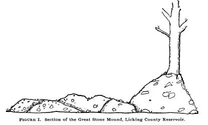
It is one of the greatest mounds in the State, but has never been generally known because at the time of the construction of the Reservoir, most of the sandstone blocks and fragments of which it is composed, were hauled away by the contractors and utilized in the formation of the Reservoir walls. At the present day it is upon the farm of Mr. Owen Brown. Early in April, 1896, the structure was of the following dimensions: 189 feet northeast and southwest; 207 feet north- west and southeast; average height 81/2 feet; maximum height 12 feet; minimum height 5 feet. From traditions and publica- tions of early archaeologists and from the curve preserved by a large tree on the north side, it must have been about 55 feet in height when completed. This tree, some five or five and a half feet in diameter, has an extensive spread of roots and holds in place a bulk of material 15 by 25 feet. (Figure 1). |
|
|
|
Large stones, 20 to 40 pounds, originally composed the bulk of the mound, but these have been nearly all removed, and only the smaller ones, sand, earth and decayed vegetable matter re- main. Work was begun early the morning of the 24th of March and continued for five days with an average force of nine men. Excavations proved that the mound rested upon original sur- face yellow clay (see museum specimens in tray 6285), that the |
|
Report of Field Work. 171
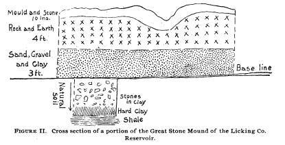
ground had been cleared and burned over; the sod line or base was one inch thick and interspersed with flint chips, burnt clay and a little charcoal and gravel. Figure II will show the struct- |
|
|
|
ure from natural clay down to shale and from the base line of the mound to the top. At this point the mound was nine feet high. Generally above the base line was three feet of clay in which a few stones occurred. The clay showed the "dumps" plainly. In some places instead of clay, sand was found, and our section exhibits such a part of the mound. As near as could be determined, an undisturbed section of the mound 40 x 20 feet was selected and an excavation sunk to the original base line. In other parts of the mound eight or ten large holes were put down, but it seems that nearly the whole of the original area covered had been disturbed by those vandals who hauled away stone, not by the hundreds but by the thous- ands of wagon loads for the Reservoir walls. Thus, in the in- terest of modern progress, was destroyed one of the most im- portant and imposing, if not unique, tumuli in the entire Ohio valley. This may seem at first sight to be an exaggeration, but let us call your attention to the facts. We have, it is true, stone fortifications, enclosures and mounds. But these are never more than 12 or 15 feet high,-while the average is less than 6 feet. Hence a stone monument 30 feet high would be both unusual |
172 Ohio Arch. and His.
Society Publications.
and unique-a freak, as it were. Imagine
the importance in pre-
Columbian times, of a stone mound 50 or
55 feet in altitude.
What important personages must have been
interred in it! One
old man, who visited the mound, said
that as a boy he had seen
several skeletons, covered with copper
rings and plates, sur-
rounded by chestnut logs. He thought
these were found near
the north side. Our excavations in sites
which we took to be
undisturbed, yielded no returns. Too
thoroughly had the ignor-
ant teamsters done their work of
demolition.
One can conceive the magnitude of the
task undertaken by
the builders when it is remembered that
the most conservative
estimate places the number of wagon loads
of stone hauled from
this mound at 5,000.
The large mound was originally
surrounded by a low em-
bankment of earth which has disappeared.
South of the mound
is a small one 250 feet distant. It was
40 feet east and west, 28
feet north and south, and three feet
high. It is composed of
yellow clay and on the top were some
large stones weighing from
40 to 60 pounds, about one hundred of
them. We cannot as-
sign a reason for its construction. We
dug 20 x 25 feet, taking
out all of the original mound. In the
mound were found some
burnt stone and one arrow-head.
We can find but one satisfactory
reference to the explora-
tion of this structure, and that is in
Rev. J. P. McLean's "The
Mound Builders:"* "Perhaps the
largest and finest stone mound
in Ohio was that which stood about eight
miles south of Newark,
and one mile east of the Reservoir on
the Licking summit of
the Ohio Canal. It was composed of
stones found on the ad-
jacent grounds, laid up without cement,
to the height of about
50 feet, with a circular base of 182
feet diameter. It was sur-
rounded by a low embankment of oval
form, accompanied by a
ditch, and having a gateway to the east
end. When the Reser-
voir, which is seven miles long, was
made, in order to protect
the east bank so that it might be used
for navigation the stones
from this mound were removed for that
purpose. During the
years 1831-32 not less than fifty teams
were employed in haul-
ing them, carrying away from 10,000 to 15,000 wagon loads.
* Cincinnati, 1885, page 42.
Report of Field Work. 173
Near the circumference of the base of
the mound were discov-
ered fifteen or sixteen small earth
mounds and a similar one in
the center. These small mounds were not
examined until 1850
when two of them were opened by some of
the neighboring farm-
ers. In one were found human bones with
some fluviatile shells,
and in the other, two feet below a layer
of hard white fire clay, they
came upon a trough covered by small
logs, and in it was found
a human skeleton, around which appeared
the impression of
coarse cloth. With the skeleton were
found fifteen copper rings
and a breastplate or badge. The wood of
the trough was in a
good state of preservation, the clay
over it being impervious
to both air and water. The central mound
was afterwards
opened and found to contain a great many
human bones but
no other relics of any note."
In the possession of a farmer we saw an
X-shaped copper
ornament which he claimed came from the
mound. It will be
remembered that the so-called "Holy
Stone of Newark" was
found in this structure encased in a
stone box. While any arch-
aeologist would admit the genuineness of
the copper cross and
bracelets, they have proven that the
"Holy Stone of Newark"
is a "fake" pure and simple.
Mr. Warrick is the only surviving
workman who assisted in the excavating
at the time of the
discovery. He knows nothing personally
of the "Holy Stone,"
but did see the other relics. In this
connection it might be well
to quote the expose as published in
"Primitive Man in Ohio.:"*
"Some writers have misrepresented
and distorted field tes-
timony to uphold theories previously
formed. As an illustra-
tion of this, and of the great damage
that it has done, we need
but call the attention of our readers to
the famous 'Holy Stone of
Newark.'
"An enthusiastic archaeologist
resided many years ago at
Newark, O. He was thoroughly in love
with his work, and his
life's ambition was to discover the
origin of man upon the Amer-
ican continent. He believed the lost ten
tribes of Israel to be
the ancestors of the mound-building
tribes. After opening
mound after mound and finding no
evidence whatever in sup-
port of his hypothesis, he became desperate.
He purchased a
* G. P. Putnam's Sons, New York, 1892,
page IV, preface.
174
Ohio Arch. and His. Society Publications.
Hebrew Bible and primer and shortly
afterwards there was dis-
covered in a stone box, in a mound that
he had investigated,
a slab, on one side of which was a
likeness of Moses, and on the
reverse an abridged form of the ten
commandments. The stone
attracted world-wide attention, and many
publications were is-
sued describing it. No one doubted the
genuineness of the
affair until after the man's death. In
cleaning up his office the
administrator found in a small rear room
bits of slate with at-
tempts at carving Hebrew characters upon
them. They also
found a fair copy of the wood-cut of
Moses used as a frontis-
piece in the testament.
"The influence of this over-zealous
deceiver has gone
throughout the length and breadth of our
land, and one may
still hear at lectures upon American
archaeology statements con-
cerning the Indian's descent from the
Jew, basing such asser-
tions upon the testimony of the supposed
'Holy Stone of New-
ark,' which, as is above shown, was
simply a counterfeit."
We could not detect a trace of the small
earth mounds men-
tioned by Rev. MacLean. Man has
destroyed them all. Con-
sidering the size and character of the
mound, one would nat-
urally suppose that it would have
contained much of value and
importance. Viewed in this light our
work was a disappoint-
ment.
FRANK YOST'S MOUNDS.
A large irregular fortification and
three mounds occur upon
the farm of Mr. Frank Yost, three and a
half miles south of
Thornville, on a hill some 100 feet in
height. Clay is used in
their composition. The group is distant
about two miles from
the great stone fort on the hill south
of Glenford. South of the
fortification and almost adjoining it,
is a circle enclosing a bird
with wings outspread. The circle, as
near as we could judge
without the use of surveying instruments
and employing a hun-
dred-foot tape, was 652 feet around, 31
feet wide and 4 feet high.
Its gateway faces to the north and was
23 feet wide. The bird
effigy (body, head to tail), is 48 feet
north and south. The east
wing is 122 feet from edge of body to
tip; west wing 111 feet
from edge of body to tip. The body is 20
feet wide. The total
Report of Field Work. 175
length from tip to tip is 253 feet.
Measurements of the wings
20 feet from the ends are, east wing 31
feet, west wing
30 feet. A ditch existed between
the bird and the cir-
cle. It has filled considerably and is
now 18 inches deep. Its
original depth was about four feet. The
original distance from
the bottom of the ditch to the top of
the circle was 9 feet. The
head of the bird was 28 feet from the
center of the circle bank.
A small mound 100 feet northwest of the
circle was opened
and in it was found much burnt earth,
charcoal and calcined
stones, but no specimens. The mound is
40 feet in diameter
and 4 feet high. There was a large
deposit of burnt clay in the
bottom. We excavated in the bird effigy,
finding ashes.
Mr. Austin Cooprighter owns an adjoining
farm to Mr. Yost,
and upon his land runs the same
embankment for some four or
five hundred feet. On the first terrace
on Jonathan Creek, dis-
tant 300 yards from the fortification
above, are two elongated
mounds, one headed north and south and
the other east and
west. Large holes were sunk in Mr.
Cooprighter's mounds and
in the largest one were ashes, mica and
burnt clay in quan-
tities. Neither relics nor bones were
found. Some time was
spent in surface hunting over
neighboring village sites with pro-
fitable results.*
IRVIN YOST'S MOUND.
On a high hill three and a half miles
south of Thornville,
is a mound 51x56x41/2 feet. With the
exception of a few large
stones near the center, the mound was
composed entirely of
clay. We began on the south side with a
trench 36 feet wide
and carried it entirely through, finding
charcoal, burnt earth,
pottery fragments, flint implements, a
circular disc and a hema-
tite celt. Some decayed bones, all that
remained of a skel-
ton, were found. A village site extended
to the northwest of
the mound.
Mr. Atwater in his volume,
"Archaeologia Americana," de-
scribes the great stone work in Perry
County, five miles north-
* Dr .Cyrus Thomas in a Smithsonian
Institution Bulletin (Washing-
ton, 1891), entitled "A Catalogue
of Prehistoric Works", reports some
eight remains in Perry county.
176
Ohio Arch. and His. Society Publications.
west of Somerset, or one mile from
Glenford.* His descrip-
tion is valuable in that it gives us
some conception of the height
of the walls and of the mound they
surrounded. He says it
resembled a sugar loaf and was 12 to 15
feet high at the time
of his visit. We can judge of the
enormous amount of stone
taken away by neighboring farmers and
contractors, for the
mound is to-day but a pitiful heap of
stones and the wall in places
has about disappeared.
Not only because of their geographic
position but also on
account of similarity in construction
and contents, do the
mounds of Perry County belong to the
Muskingum tribe. Art,
as found in them, does not evince a high
degree of culture, but
it is very ancient and therefore of
paramount importance. Per-
haps one makes no mistake in venturing
the suggestion that the
people in this region had no commerce
with other tribes. Cer-
tainly there is not sufficient mica,
copper and other foreign sub-
stances to prove that trade relations
existed.
Never have we witnessed so many chips
and discs of Flint
Ridge material (except at the Ridge
itself) as occur upon the
Perry County sites. Nearly every knoll
was a workshop. Boys
and farmers find thousands of arrows,
spears, knives and scrapers
of this material and yet the supply does
not seem to be exhausted.
Little other material occurs.
Flint Ridge stone being found in every
county of Ohio set-
tles as a fact the proposition that
while we may consider one
section of the State older than another,
yet the quarries at the
Ridge were worked through a long period
of time. It is cer-
tain that the earliest men in Ohio
resided within the State but
a short time before they discovered and
utilized Flint Ridge ma-
terial. In this connection it would be
interesting to ascertain
if the quarries upon the Walhonding
River are older. It is just
possible that both localities may have
been developed at the
same period.
SECTION 2. THE MUSKINGUM VALLEY PROPER.
On May 6th Mr. Walter O'Kane and myself
left for Mans-
field with the intention of following
the Muskingum from its
* American Antiquarian Society,
Worcester, Mass., 1820, page 132.
Report of Field Work. 177
source to the Ohio River. Our mission
was two-fold-to locate
upon our State archaeological map all
the ancient remains in the
region and to explore burial places and
collect specimens. The
Muskingum as a whole has never been
investigated by any insti-
tution and there was, consequently,
almost nothing known re-
garding its pre-Columbian occupation
except at three localities-
Newark, Loudonville and Marietta.
Proceeding east from Mansfield we struck
the head waters
of Black Fork at a point where the
stream was some twenty feet
in width. We followed this down through
Mifflin and Perryville,
Ashland County, also through the edges
of Holmes and Knox.
As we drew near to Coshocton the valleys
deepened and other
tributary streams swelled the stream
until it became the Mohican
River and presently the Walhonding. We
found many gravel
burials, especially between Loudonville
and Warsaw, but they
were most numerous around Warsaw,
Mohawk, Mifflin and
Zanesville. We do not consider that the
gravel knoll burials
were made by the same tribe which
erected the tumuli, but by an
earlier and more primitive one.
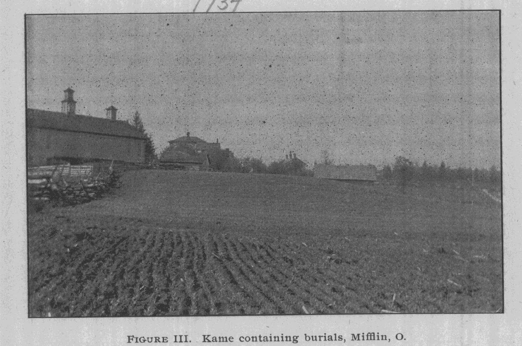
MIFFLIN, ASHLAND COUNTY, BLACK CREEK
VALLEY.
On Mr. C. C. Stamin's farm are several
gravel knolls or
glacial kames. In two of these decayed
skeletons have been
found three to five feet from the
surface. About fifteen were
found when grading for a bank barn was
in progress. A few
flint implements were with the bones. In
searching the fields
we found a hematite celt and a flint
knife. Figure III shows Mr.
Stamin's kame and barn on the site of
the skeleton finds.
We dug several holes about the lame
(shown in photograph,
16,201 museum number), but found no
skeletons, all having been
removed. In a large gravel hill at the
edge of Mifflin we also
dug without results. There are few
mounds this far up the
stream.
Reaching Perrysville we met Professor
Sample, who has a
large collection. He located mounds and
village sites on our
map. En route to Perrysville we stopped
at the Copus monu-
ment, where whites were killed by
Indians in 1812, and photo-
graphed it. It is an historic spot. We
met and conversed with
|
178 Ohio Arch. and His. Society Publications.
the grandson of the pioneer. At this point, as throughout the valley, we purchased specimens of farmers. |
|
|
|
From Perrysville Mr. O'Kane inspected the Delaware village site three miles up the stream, known as "Black Fork of the Mohican." He looked for graves and lodge sites, but was unable to find them, though he dug several deep holes. He also saw two mounds. Both had been examined.
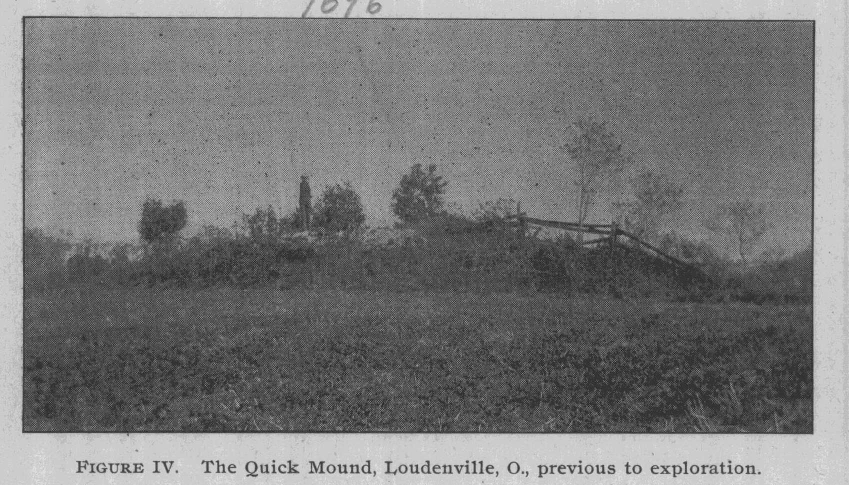
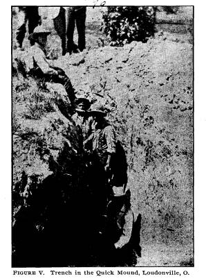
LOUDONVILLE, ASHLAND COUNTY. We began work the morning of the 8th on the Quick farm. There are two mounds, one about obliterated and the other stand- ing 9x72x68 feet. The former is in low ground and the latter on a hill of 200 feet elevation. They are in the edge of Holmes County, just a little over the line in Washington Township. The nearly obliterated one was about ten inches high and was speedily excavated. Nothing in it. The large one is composed of dark red clay and is shown in Figure IV. It had been partly dug some sixty years ago. In it were found two skeletons, a boulder layer and a slate |
|
Report of Field Work. 179
ornament. There were slight evidences of camp sites in the ad- joining fields, but more in the valley below, along the stream. We sunk a trench eight and one-half feet wide and nine feet deep and continued the same around the mound, widening it at the bottom. We found the mound had been built over a slight depression and therefore while but seven feet high on the north side, was nine feet on the east and south sides. It was erected upon a burnt floor or base. Above this was a dark streak one-half inch wide; then a layer of ashes and pottery fragments and burnt bones one-half inch thick. A hard burnt |
|
|
|
"pan" or floor, one inch thick and cement-like in character was above this. It seems to have extended over a space 12x15 feet. From the summit down to within one foot of the base line the structure exhibited no stratification. There was a heavy deposit of white earth eight inches thick above the hard floor. We extended our trench forty feet in total length around the old or central excavation, examining all the earth as far as there were indications of burials, ashes, pottery, etc. We found, some sixteen feet southeast of the center, a skele- ton on the base line. It was much broken and decayed. How- ever, a large piece of skull and some of the leg bones were secured. Thirty-five or forty beads lay about the neck. All the earth around |
180 Ohio Arch. and His. Society Publications.
the skeleton was carefully examined with
trowels, also sifted
through our hands in search of more
beads, but the string had
been a small one.
The legs of the individual were crossed
at the knees. Under
them were some small pebbles of
irregular shape.
Animal bones, chiefly deer, were in the
ashes below the hard
floor. Some fifty of these were found
and about 400 pottery frag-
ments.
Upon completion of the work we filled
the trench to within
a few inches of the top. Figure V shows
a section of our trench
and its curvature.
We inquired of local collectors as to
other mounds, but ascer-
tained that all of them had been
excavated.
Mr. H. B. Case, of Loudonville, was with
our party during
the work in Ashland County. In the
Smithsonian Institution
report for 1881, pages 592 to 601, he
describes the antiquities of
his county. All the remains he mentions,
together with some
thirty others which we discovered, have
been transferred to our
State archaeologic map. As Mr. Case is
an authority we will
present his report in full.
"A square inclosure with a gateway
to the southwest is situ-
ated in section 36, Clear Creek
Township, on the line between
the northwest and southwest quarters of
the section, upon land
owned by John and Thomas Bryte. It is
about 400 feet long
by 200 feet wide, and has a gateway at
the southwest corner near
a very strong spring. In 1824 Mr. Bryte
commenced to clear
his farm. The embankment at that time
was from three to four
feet high and ten feet wide at the base.
Both the embankment
and the area were covered with large oak
trees. The place now
goes by the name of Bryte's Fort.
"Two mounds stand upon a high
natural elevation (90 feet),
covering about five acres at the base, and
being about 60 by
90 feet on the top, which is nearly
flat. Each is twenty-five feet
in diameter and four or five feet high.
They are situated on the
northeast quarter section 35, Clear
Creek Township. At least
one of them was explored as early as
1844, by Thomas Sprott and
brother, who found a number of human
skeletons in a kind of
|
Report of Field Work. 181
stone cist, upon which was almost a peck of red Indian paint. The bones were replaced. "A circular inclosure containing two acres, more or less, is situated just north of the Atlantic and Great Western Railway |
|
|
|
and within the city limits of Ashland. The farm was formerly owned by Henry Gamble. In 1812-'15 the first settlers found embankments from three to four feet high and from eight to ten feet wide at the base. A forest of oak, hickory, sugar and ash grew upon and near this work. It overlooked the valley to the south and east, and had a gateway at the southwest opening near a fine spring. The site has been plowed for more than fifty years; and scarcely a trace of it remained in 1878. |
182
Ohio Arch. and His. Society Publications.
"There is a circular inclosure
located near the north line of
the northeast quarter section 9, Mohican
Township, one mile east
of Jeromeville.
"On the farm of Nicholas Glenn is a
mound and an earth-
work. Information might be obtained from
John Glenn, Jr., or
from William Gondy, an old settler, both
of whom live at Jerome-
ville, Ohio. The works are about two
miles southwest of Jerome-
ville.
"The Mohican town called Johnstown
was located here. In
the years 1808-'10 it contained
Delawares, Mohegans, Mohawks,
Mingos, and a few Senecas and Wyandots.
Captain Pipe, a
Wolf Indian, ruled the village until he
left it in 1812.
"A large circular inclosure and
burial mound are situated
in Wayne County, just south of the road
leading from Lake
Fork to Blatchleysville and just east of
the road leading from
McZena to Blatchleysville. These remains
are upon a high,
gradual elevation overlooking a vast
range of prairie, northeast
and southeast, as well as the valleys
westward. The circle is
a little less than one-third of a mile
in circumference. At present
the embankments are from one to two feet
in height. The area
and embankment are covered by the forest
growth, which is not
older than sixty or seventy years, the
Indians having burned this
region annually until about 1812, for
the purpose of hunting.
Years ago the mound was opened by
unknown persons. In 1876
the author visited it, and found that an
animal had burrowed into
it and brought out a fragment of skull,
which is now in his
possession. Some time after, Mr. Thomas
Bushnell, of Hayes-
ville, made excavations in the mound and
found only bones,
among which was a well-preserved skull.
The mound is twenty-
five or thirty feet in diameter and four
feet in height.
"A small mound, three or four feet
high and fifteen feet in
diameter, stands upon a very high hill,
perhaps the highest land in
the county, and is composed of stone and
clay. It was excavated
some years ago by Dr. Emerick and a Mr.
Long, who are said
to have found a skeleton in a kneeling
or sitting posture, and a
pipe, both near the center. The author
was unable to learn what
had become of the pipe. Messrs. H. B.
Case and J. Freshwater
made another examination in 1876, but
found nothing. There is a
Report of Field Work. 183
large spring at the foot of the hill, on
the east side, but it is nearly
half a mile from the spring to the mound
on the hill.
"In 1876 the author, in company
with Mr. J. Freshwater,
made a slight examination of this mound.
It is twenty or thirty
feet high, oval in shape, and over 100
feet long. The citizens
regard it as an artificial mound, but we
considered it a natural
elevation of gravel drift. Excavations
might change this view.
The mound is located on the west side of
the Lake Fork, and just
north of the road and bridge leading
from Mohican to McZena
in Lake Township.
"A mound is situated on the lands
of J. L. and Cyrus Quick
in Washington Township, Holmes County,
Ohio. It stands
upon an eminence which slopes gradually
for half a mile south-
ward toward the bottom lands of the Lake
Fork; northward and
westward it declines a short distance to
a small valley extending
to the southwest. It is about five or
six feet high, and thirty feet
in diameter. Some trees were growing
upon the mound when
the author first visited it, some
twenty-seven years ago. The
trees were perhaps not of more than one
hundred years growth,
but were as old as the trees in the
immediate vicinity; not far
from it, however, were oak trees two and
three feet in diameter,
The mound was excavated about 1820-'25
by Isaac and Thomas
Quick, Daniel Priest, and others. It is
said that, upon making
a central excavation, they found a
wooden puncheon cist, to-
gether with some human remains, and
ornaments of muscle shell,
which appeared to be strung around the
neck. All the remains
are reported to have crumbled away on
being exposed to the air.
It is difficult to ascertain the facts
concerning this excavation. It
has been said that some pottery was
found also. Additional re-
mains might be disclosed by further
investigation. The persons
who made the excavation are dead.
"A lake is situated a short
distance from the mound, on the
farm of D. Keck, Washington Township,
Holmes County, Ohio,
In draining this pond a cache of flint
implements was discovered.
Specimens of these implements may be
seen in the Smithsonian
collection. The remainder are in the
author's possession. (See
Smithsonian report of 1877, article by
H. B. Case.)
"There are mounds southeast of
Odel's Lake, upon the sum-
184
Ohio Arch. and His. Society Publications.
mit overlooking the lake, on the farm of
J. Cannon. They were
excavated by Dr. Boden, of Big Prairie,
Ohio, who has in his
possession some teeth, jaw bones, and
long bones taken from
them. He says that they should be
further examined. The
author has not visited the mounds.
"A mound stands on the summit of
Dow's Lake, one mile
northeast of Loudonville, just east of
the Holmes County line.
It was excavated about 1855 by Dr.
Myers, of Fort Wayne, and
D. Rust, who found a skeleton near the
center, whose structure
is of stone and earth. The top has since
been leveled by the
plow. In 1876, Mr. Lucien Rust made some
excavations upon
the site of the mound, and great numbers
of stone were re-
moved. At length a kind of pot or cist
was unearthed, which
was about 18 inches in diameter and 8 or
9 inches deep. It was
formed of stone, and the edge was
covered by other stones which
made a roof over the pot. The removal of
this roof or top
showed that the cist was filled with
charcoal, apparently closed
while glowing coals. About 4 feet below
this charcoal deposit
human remains were found, reposing
horizontally. Near the
left hand was a perforated stone having
the figure of a bird, re-
sembling slightly the pheasant,
scratched upon it. A part of a
bone implement was also found. The bone,
which is of firmer
texture than the human bones, and is
perhaps a part of the leg-
bone of a deer, had been perforated,
evidently with a stone drill.
Lying across this lower skeleton and
some distance above it were
the remains of another. But little of
the mound has been excava-
ted and further examination should be
made. From the mound
the view of the surrounding country is
very fine. The mound
proper has been obliterated for some
years, but the site can be
observed by a slight elevation and the
great number of stones
scattered about and upon it. There must
have been a kind of
hollow made in the Waverly shale which
lies near the surface
upon the underlying Waverly sandstone,
of which the hill is
composed, because when one digs the same
depth elsewhere on
the hill the shaly sandstone is
penetrated. The stone implement
is in the possession of L. Rust,
Loudonville; the bones, bone
implement, and charcoal are in the
author's cabinet.
"A mound is situated just north of
Loudonville, on the sum-
Report of Field Work. 185
mit of Bald Knob. For a long time it was
supposed by the
citizens of Loudonville to have been
formed by counterfeiters
in former times. The author excavated it
in 1877, and found
it a veritable mound containing
fragments of human bones and
of charcoal. Being encased with large
sandstones, and com-
posed of stone and earth, it is very
difficult to excavate. As
there has been a central depression for
a great many years, what
remains the mound contained of a
perishable character have
probably been destroyed by the
collecting of water. This site
also commands a fine view of the Black
Fork valley.
"The settlers of 1808-'09-'10 found
here a village of Dela-
wares, the remnant of a "Turtle"
tribe. Their chief was a white
man, taken in infancy-Capt. Silas
Armstrong. They removed
to Piqua, Miami County, Ohio, in 1812,
the site of the old bury-
ing-ground, now almost entirely
obliterated by cultivation. It
is located a few rods north of the Black
Fork, upon a gentle emi-
nence, in the southwest part of
northeast quarter section 18,
Green Township. The southern portion of
the site is still in
woods, and the depressions that mark the
graves are quite dis-
tinct. Henry Harkell and the author
exhumed several of the
skeletons in the summer of 1876. In some
cases the remains
were inclosed in a stone cist; in
others, small rounded drift-bowl-
ders were placed in order around the
skeletons. The long bones
were mostly well preserved. No perfect
skull was obtained, nor
were there any stone implements found in
the graves. At the
foot of one a clam shell was found. The
graves are from 21/2 to 3
feet deep, and the remains repose
horizontally. A few relics,
such as stone axes, arrow-heads and a
few bits of copper, have
been picked up in the immediate
vicinity. They are in the hands
of the author. On the opposite side of
the stream and some
distance below, near the south line of
southeast quarter-section
18, Green Township, there are ancient
fireplaces. They are about
15 inches below the present surface, and
are formed of bowlders,
regularly laid. The earth is burned red. Great numbers of
stones have fallen into the stream
during its incursions upon the
west bank. Some three or four of these
fireplaces are yet plainly
visible, but in a few years they will be
swept away by the cur-
rent. About half a mile east of the
graves is a small circular
186
Ohio Arch. and His. Society Publications.
earthwork almost razed. It contained
about 1� acres, and
had a gateway looking to the river,
which is westward. It
is situated upon the nearly level bottom
land of the beautiful
valley.
"Upon the high ridge separating the
valleys of Black Fork
and Honey Creek is a depression filled
with large and small
bowlders. J. Freshwater and the author
removed them to some
depth, but as the stones were heavy we
desisted from further in-
vestigation. This point would command a
view of the valley
of the Black Fork, overlooking, as it
does, the old village of
Greentown; and by walking a few rods
eastward on the same
eminence a view of the valley of Honey
Creek might be had.
Most of the trees on this height are
less than 100 years old. It
may have been timberless during the
occupation of this work.
The excavation appears to have been
about 15 feet in diameter.
"There is a stone mound, situated
on a lofty eminence
overlooking the Black Fork valley
northwestward, and east-
ward the valley near Loudonville. The
author has never
seen the work, but it has been described
to him as a small stone
and earth mound such as are usually
found on high points.
"A short distance northwest, on the
farm of L. Oswald,
southwest quarter-section 18, in the
woods, is a mound about
30 feet in diameter and from 4 to 6 feet
high. It was slightly
opened at the center by the owner of the
lands, who found part
of a skull.
"A mound and earthwork are located
upon the old Parr
farm, now owned by C. Byers, in the
northwest part of south-
west quarter-section 19, Green Township.
The mound stands
on the west side of the Black Fork,
within 2 or 3 rods of the
stream. It was quite large originally,
perhaps 8 or 10 feet high
and 35 to 50 feet in diameter. At
present it is from 4 to 6 feet
above the level of the bottom land and
is spread over a consid-
erable space. When the first settlers
came, there was an earth-
work running a little southwest from the
mound for some 20
rods, then back eastward to the river.
The place has been un-
der cultivation for forty or fifty years
and the work is now ob-
literated. The mound was encased with a
wall of sandstone
bowlders as large as a man can lift.
Report of Field Work. 187
"These stones must have been
carried from the hill half
a mile west where they are found in
place. The wall was care-
fully laid, as can be seen by
excavations below the depth of the
plow where the pile is still intact. The
mound was examined
in 1816 by some persons named Slater,
who found in it bones,
flint implements, a pipe, and a copper
wedge which they thought
gold. Accordingly they took it to a
silversmith at Wooster,
Ohio, who told them that it was copper,
and bought it from them
for a trifle. In 1878 the mound was
explored by J. Freshwater
and the author. The center of the mound,
where not disturbed
by former excavations, resembles an
altar or fire-place where
the fire had burned the earth to a
brick-red. In the ashes and
burnt earth were fragments of
arrow-heads broken by the heat.
The fire had been kindled on the mound
when it was from 2�
to 3 feet high. No human remains were
discovered in this last
excavation. A few scrapers were found,
which are in the cab-
inets of the above named gentlemen.
"On the summit of a hill west of
Perrysville, and to the right
of the road leading to Newville, was a
mound, now entirely
obliterated. In 1816-'20 it was opened
by the Slaters, who found
a pipe, human remains, and some other
relics.
"A large oval earthwork is on the
summit of the ridge be-
tween the valleys of Black Fork and
Clear Fork. It is 210 feet
wide by 350 feet long. About the center
of the inclosure was
a large pile of stone bowlders, most of
which have been removed
to the level of the ground. There is,
however, a visible outline
of the stonework, which consisted of a
paved circular space.
No excavation has been made in either
the stone or clay work
beyond 1 or 2 feet in depth;
consequently the character of the
mound is unknown. A forest, containing
oak trees over 30
inches in diameter and other large
trees, covers most of the work,
but a portion extends into a field and
has been almost razed
by the plow.
"On a high hill directly north of
the junction of the Black
Fork and the Clear Fork, and overlooking
the same, is a stone
and earth mound composed principally of
large sandstones from
the immediate vicinity. Some twenty or
twenty-five years ago
it was explored by unknown persons. The
author examined it
188 Ohio Arch. and His. Society Publications.
again in 1877, but discovered nothing. A
similar mound is said
to have been located upon the hill south
of the Clear Fork, just
below the junction of Pine Run. The
stone were hauled away
and the site plowed over.
"The old Delaware village of Hell
Town is on the Clear
Creek in Richland County, near Newville.
It is on the south
side of the stream about 4 miles from
the Ashland County line.
It was deserted about 1782, the time of
the massacre of Gnaden-
hutten. Graves were visible until two
years ago; the field is
now cleared and plowed. In the author's
cabinet are two iron
scalping-knives and an iron tomahawk
which were thrown up
by the plow; also the brass mountings of
a gun, a gun-flint, a
stone ax, and some arrow-heads. Dr.
James Henderson of New-
ville, Ohio, has in his possession
several articles obtained from
this site. The Indians formerly called
their settlement Clear
Town, and the stream Clear Fork, but
learning the German
word hell, for clear or bright, they
changed the name to Hell
Town.
"A rock shelter is located on the
west side of Clear Fork,
in the conglomerate sandstone of the
Lower Carboniferous. It
was explored in 1877 by L. Rust and the
author, who found
about 2 feet of ashes intermingled with
a few animal bones and
coprolites. No human remains were
disclosed excepting a split
bone, and even that is doubtful. The
ashes continue deeper, and
further examination might prove
interesting."
At Brink Haven the stream (Mohican
River) is large and
can be navigated in a canoe. There are
many stone mounds
on both sides, upon the high hills.
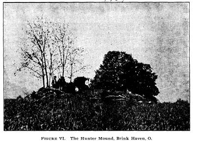
On the Hunter farm one mile below the
village, is a small
mound 3 feet high and 35 feet base, made
of yellow clay. It
is shown in Figure VI. Although
thoroughly examined, there
was nothing found in it.
Mr. Gann lives opposite the Hunters,
across the Mohican.
On his farm are two mounds 300 yards
apart. One is 4 feel
high and 35 feet base. Both are injured
by cultivation. In
the larger one we found some charcoal.
Four large white flint
arrow-heads lay about a foot from the
surface near the center.
Nothing else was found.
|
Report of Field Work. 189
The small mound contained charcoal and burnt earth. There were no bones or relics. Both mounds were examined thoroughly. |
|
|
|
We reached Walhonding late in the evening of the 12th. We saw a cache of rough flint implements in the possession of Mr. George Workman. He found them in a pit 3 feet deep when clearing a woods. They occupied a space 2x11/2 feet, and num- bered more than 400. People have carried off about half of the cache. The others yet lie in his yard. We went six miles up Green valley to Mr. Staats', where a large mound 7x65 feet was reported. It had been excavated, some one having run two large cross trenches through it. We did not attempt to dig in it. On the Gamble farm, 31/2 miles up Owl Creek, were two mounds in the front yard. Each was 40x4 feet and the edges within 20 feet of each other. Both were thoroughly trenched, but nothing was found, except two small arrow-heads. It is singular that the Muskingum mounds contain so little. We cannot account for it save in this wise: that the culture was |
|
190 Ohio Arch. and His. Society Publications.
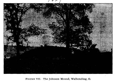
very low and the mortuary customs different from those in vogue in the Scioto valley. On the way back in passing a gravel pit we secured the skeleton of a young person. It had been buried near the pit by the workmen who exhumed it. Walhonding appears to have been built over several mounds and a village site. On the north edge of the village are two mounds yet standing. One owned by Mr. Johnson is 9 feet high and 69 feet in diameter at the base. Mr. P. Neff had sunk a trench through it several years ago. We found his trench to be 5 feet wide at the top and 4 at the bottom. He does not report having made any discovery. There seems to have been no considerable number of bur- ials in this structure, for we found only one decayed skeleton, near the center and 3 feet above the base line. Nothing re- mained but the teeth. Not far from the bones was a cone-shaped stone (see Figure XXV). There were a few broken and one |
|
|
|
whole arrow-head scattered through the soil. Little burnt earth and charcoal on the base. |
|
Report of Field Work. 191
The mound was very promising and we could not account for its lack of contents. See Figure VII.
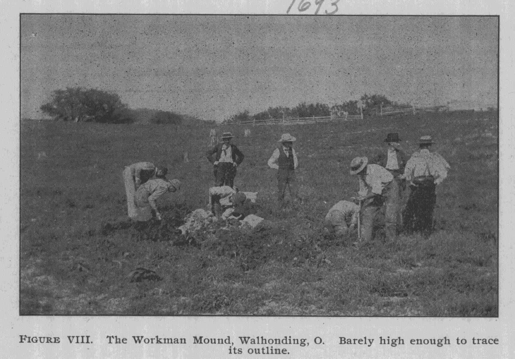
THE WORKMAN MOUND. On the farm adjoining Mr. Johnson's there is a small mound 2 feet high and 60 feet in diameter. It originally stood some 5 feet high but had been reduced by cultivation. The excavating re- quired but a trifle over an hour, yet the results were very sat- isfactory. (See Figure VIII). |
|
|
|
Near a decayed antler and other deer bones, was found an unfinished stone tube of hard material. The perforation is but begun, yet the stone is dressed and ready for polishing. A little south of the center of the mound were traces of bone, but so decayed that nothing could be preserved. Above these traces and lying in a layer with edges overlapping were 67 leaf-shaped implements.* They are all of clear chalcedony. North of them were some 500 small scales and fragments of flint (of the same kind) in a heap or pocket. We take it, from their size and * See also Figure XXIV, page 238. |
192
Ohio Arch. and His. Society Publications.
form, that they are the very fragments
struck off in the man-
ufacture of the leaf implements. Never
having heard of a cache
accompanied by the chips and spalls, we
look upon this dis-
covery as one of interest to the
archaeological world.
Dr. Cyrus Thomas, in his Catalogue of
Prehistoric Works,
notices in Coshocton County 16 various
remains. Our survey
noted all of these, examining most of
them, and recorded some
thirty additional ones. Dr. Thomas says:
"At Flint Ridge, on
the north bank of the Mohican River,
between Walhonding and
Warsaw, numerous pits show that is was
much worked. There
is a thick layer of dark flint
overlooking a stratum of chalcedony;
the latter seems to have been the kind
sought." While most
of the implements in the valley for
twenty miles either up or
down from the quarries seem to be of the
Coshocton flint and
chalcedony, yet the Muskingum valley as
a whole was supplied
from Flint Ridge in Licking County. The
Coshocton quarries
are small and of limited extent compared
with those of Flint
Ridge. The same methods of quarrying
seem to have been in
vogue and a description is therefore
unnecessary.
A deposit of chalcedony (the implements
found in the Work-
man mound above Walhonding seem to be of
material from this
quarry) occurs upon the farm of Col. P.
Methan in the south
central part of Jefferson Township.
In Muskingum Dr. Thomas reports three
mounds and one
group of enclosures. The latter are near
Zanesville and were
described in "'Ashe's
Travels," page 108. The works are now
about obliterated.
THE LARGE PORTEUS MOUND.
In the neighborhood of Coshocton there
were a large num-
ber of mounds and village sites. The
town itself has covered
two mounds and obliterated a large
village site. Few town sites
in the Ohio Valley can lay claim to
being both prehistoric and
historic, but Coshocton can justly
assume this honor. After the
mound period it was inhabited by the
Delawares, Mingoes, Shaw-
nees and other tribes from 1720 to 1790.
The student of Indian
and pioneer history is familiar with the
various expeditions sent
against the tribes of the Tuscarawas and
Walhonding. Memo-
|
Report of Field Work. 193
ries of such names as Logan, Cornstalk, the Half King, Pontiac, Brandt, etc., cluster about the place. The early missionaries- those self-denying Christians, Heckewelder and Zeisberger, also played a part in the history of the upper Muskingum. About two miles below Coshocton stand two mounds. Both are on the Porteus estate, the one twenty-three feet high and 120 feet base; the other, four and one-half feet high and fifty feet base. For many years persons have endeavored to secure per- mission to excavate them but without success. Mr. Joseph Porteus and his brother kindly gave consent for the examination of the interesting tumuli. Of the large mound little need be said. Sixteen men were employed day and night for four days in sink- ing a trench thirty-five feet wide and seventy feet long. The sides were loose and dangerous, and heavy bracing was necessary. It was composed entirely of earth and unstrati- |
|
|
|
fled. There were few pieces of charcoal noticed and no burnt earth. No difference in color was observed even on the bottom, and there were no soft places, the entire mass being hard packed. |
|
194 Ohio Arch. and His. Society Publications.
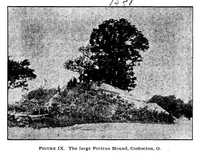
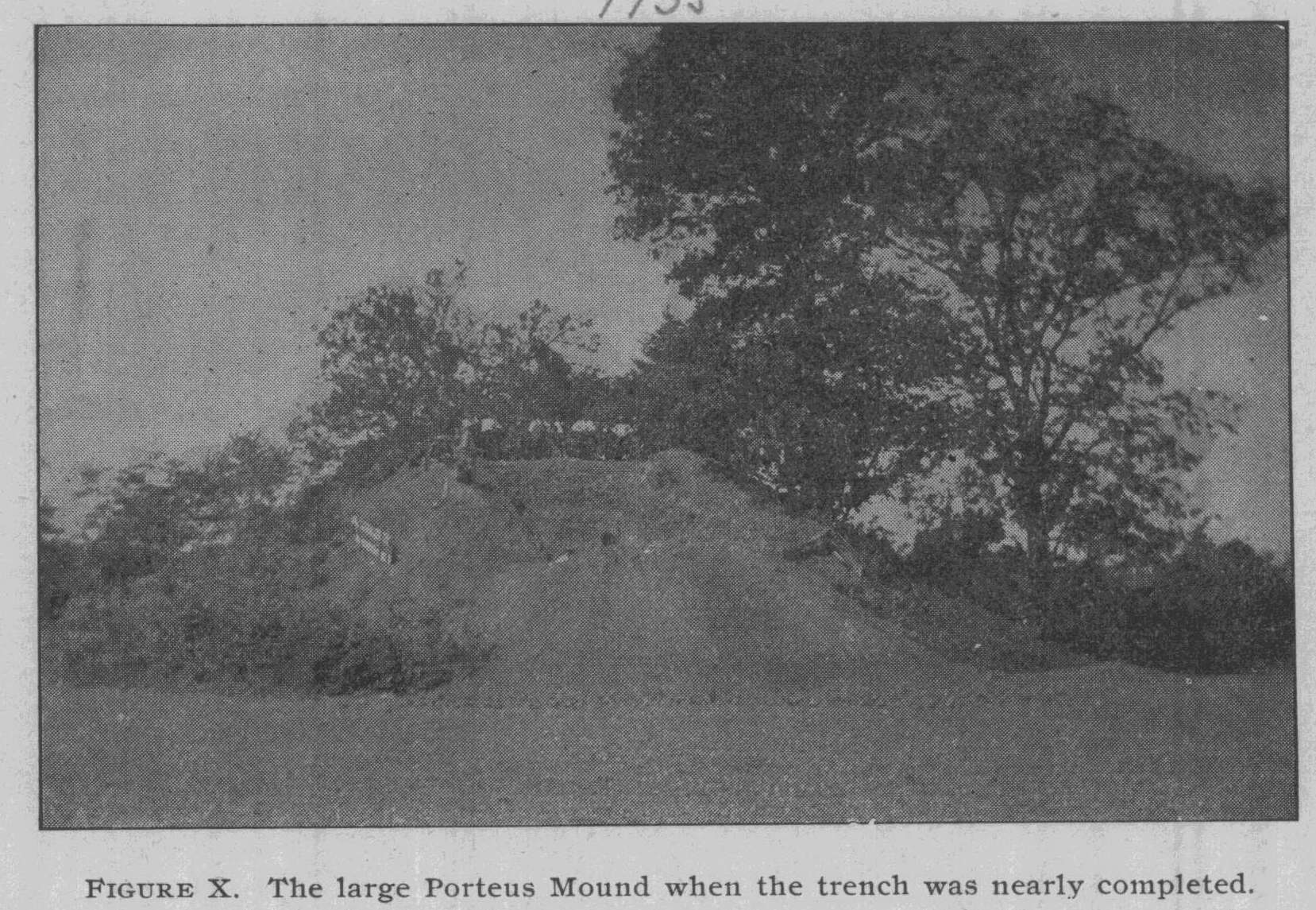
While work progressed a boy found a most beautifully chipped six-inch spear head by the base of the mound. (Specimen* 7896.) This mound is shown in Figures IX and X. It was im- possible to get the whole mound in the negative without re- moving the camera some 200 feet distant. On this account the structure appears to be smaller than it really is. Some idea of its height can be obtained by comparing the men who stand on the top with the structure from the plowed ground to its summit. After exceedingly laborious and dangerous excavation, the bottom of the structure was reached. To our chagrin one or two small bones, a ceremonial of galena, a few pottery fragments and flint chips were found. No burials were discovered, although tunnels were run in for several yards on the base line in various directions. This was disappointing, especially after the ex- penditure of a large sum of money. However, we learn again |
|
|
|
that it is not always the largest and most imposing monument which contains the greatest treasure. Failure to find anything cannot be charged to imperfect or hasty exploration-the whole * Museum number. |
Report of Field Work. 195
center of the mound was exposed by the
trench and tunnels for
a distance of thirty by twenty-five
feet. As it was desirable to
restore the monument to its former
shape, we engaged Mr. Por-
teus to fill our trench.*
Upon the same property is a small mound
situated about 400
yards north of the large one. It is four
and one-half feet high,
with a base of fifty feet. Mr. Porteus
says that it was originally
eight feet high, with a base of
thirty-five feet. As our force of
workmen was considerable, we were less
than half a day exam-
ining its contents.
Most tumuli are entirely of earth, but
this one was largely of
pure sand and rested upon a knoll of
sand. The burials were
three to four feet below the surface and
all considerably decom-
posed. Of seven skeletons exhumed, but
few fragments were
preserved. Numerous flint chips, a few
arrow-heads and three
bear tusks constituted the finds. No
order was observed in the
burials with reference to cardinal
points, nor were any two skele-
tons headed in a common direction.
The following day we visited a
fortification three miles up
the Walhonding upon Mr. Miller's farm.
It is on a hill some
200 feet high and overlooks the valley.
Many of the citizens of
Coshocton claim it to be a French fort,
but we would call it deci-
dedly Indian in form. It is some two
acres in extent, the em-
bankment low and broad. Where preserved
by woods it appears
to have originally been five feet high.
A long passage way from
the valley below leads up to it, and in
this respect the place is
peculiar. The passage is some fifteen
feet wide on the average
and walled on either side by natural
ledges eight to twelve feet
high. We think the enclosure merits
future investigation.
Up the Walhonding, three miles from
Coshocton, is a mound
five feet high and sixty feet in
diameter on the land of Mr. M. C.
Maxwell. Situated upon the second
terrace it is 200 yards from
the river. Some one had sunk a small
hole in the center. Mark-
ing a space 28x35 feet we removed about
all the area origi-
nally covered by the mound, and found
ten skeletons, some of
* At no time were less than sixteen men
employed and for two days
we had nineteen at work. No larger force
was ever put on a mound in
the Ohio Valley.
196 Ohio Arch. and His. Society Publications.
which were well preserved. The humeri
and other bones show-
ing peculiarities, we removed entire or
nearly so. Previous dig-
ging had disturbed two skeletons in the
center, cutting one body
in halves at the hips and destroying all
of another save the skull.
It was interesting to note that in the
eight years since the central
excavation had been made, the bodies
near it were more decayed
than those farther away, all of which
tends to confirm the facts
that the skeletons in a mound decay very
slowly if so placed that
water cannot reach them, and that a few
years of exposure to
moisture will cause more decay than
three hundred years of dry
interment.
As was remarked in the case of the small
Porteus mound,
no order was observed in the interment
of these remains. All
were extended and lay upon the base
line. A polished bone
knife or cutting tool, some arrow-heads,
pottery, etc., were found.
"Skeleton B" is the most
remarkable one in the mound.
When the cranium was reached, though
fragmentary, it was found
to bear evidences of having a section
about the size of a nickle
removed from the frontal bone on the
crown of the head.
Whether this is evidence of trepanning
or the result of a blow
from some round instrument, is to be
determined by one of our
medical experts. We have sent the
fragment to the Smithsonian
Institution and await the opinion of
experts in craniometry.
This having finished the work about
Coshocton, we set out
in a large skiff down the Muskingum for
Zanesville. Many,
many Indians, traders and pioneers have
made this trip, and as
we moved along we could but think of the
history of the stream
and its importance to our native
Ohioans.
At Duncan's Falls there are some tumuli,
and we opened
a mound upon the Wilhelm farm one mile
southwest of town,
upon a hill. It was of earth containing
numerous ashes. A
former excavation (small) had been put
down from the center,
and one skeleton found. The other had
not been disturbed by
this excavation. The first skeleton was
found on the north side
of the mound. The bones below the knee
were all decayed,
other parts well preserved and nearly
all saved. Near the center
was found the second skeleton. It was
buried in ashes with its
head to the north. Across the cervical
vertabrae was a clay pipe,
|
Report of Field Work. 197
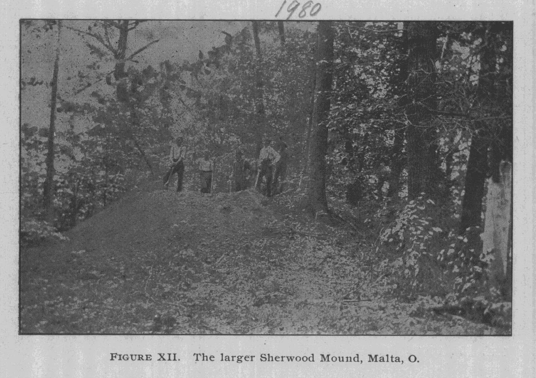
broken, but yet in such fragments as will permit restoration. Near the skeleton was a large number of charred deer bones in ashes. No chips of flint occurred in the mound. In the left temple of the skull was a hole evidently made by some sharp pointed instrument. The cranium was preserved nearly entire. Dimensions of the mound, seventy feet broad and eight feet high. Down the river at Malta (opposite McConnelsville) we found many mounds and secured permission to excavate in several. At Mr. Sherwood's farm, three miles above Malta, we found two mounds upon a hill overlooking the Muskingum. The small one was of stone, the larger of earth. Their dimensions were eighteen feet broad, two feet high, and seventy feet broad and eight feet high. In the small one were fragments of decayed bone and two leaf-shaped spear heads of great beauty. The stones were large and ran from ten to thirty pounds in weight. But thirty feet intervened between the two mounds. In the large one we ran two broad trenches, finding a layer of ashes at the bottom. No skeleton could be located, but we found a nice discoidal stone and some flint chips. There is a village |
|
|
|
198 Ohio Arch. and His. Society Publications. |
|
|
|
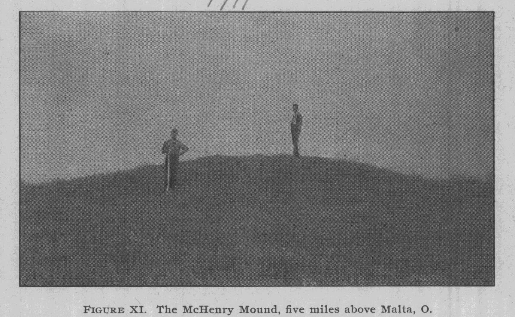
site of some acres in extent upon the terrace below the mounds. The surface material upon it is not very thick. Figure XII repre- sents the large one. Five miles north of Malta on the McHenry farm is a clay mound which has been much cultivated. It is four feet high and seventy feet base. Absolutely nothing was found in it. (See Figure XI). Upon a high hill in the edge of McConnelsville is a large mound owned by Mr. Alderman. He consented to let us explore it, although his residence is but sixty feet distant and the mound really a lawn ornament. We did the work with care and re- stored the structure to its original form. Being well preserved, this fine earth monument stands eight feet high and sixty feet base. It overlooks the river and the Sprague mound in the center of town below. Perhaps the ele- vation of Mr. Alderman's lawn above low water in the river is 175 feet. In the center, and just above the base line, we uncovered some two bushels of ashes, and in them a child's remains. But for the remarkable preservative power of ashes, these bones would have decayed long ago, for the infant was but one or two months old. A most beautiful bone awl, one of the best ever found, |
Report of Field Work. 199
accompanied the remains. There were no
other objects. In a
south side excavation we found a large
spear head of Coshocton
County material.
Mr. Sprague, who owns a large mound
directly in the heart
of McConnelsville, gave us permission to
explore in the month
of October.
Accordingly, we went to McConnelsville
the 20th of October
and thoroughly explored Mr. Sprague's
mound, also giving a
lecture in the Opera House to citizens
on the work of the
society. It was found that the mound
could be best explored
by means of tunnels and therefore we
began at the south side
and ran two main tunnels nearly through
the structure. Branches
were run from these and the whole
interior of the mound
thoroughly explored. The tunnels were
about three feet wide
at the bottom and about four feet high
and, with the branches,
extended a total of 100 feet.
The base of each tunnel was about a foot
below the bottom
of the mound. Three skeletons were
encountered, one on the
east side, fairly well preserved, and
two upon the west, both de-
cayed. The former was near the top of
the mound and had been
covered by large, flat limestone slabs.
The latter were upon
the base line and we considered them
original interments. The
first may have been an intrusive burial.
With one of the decayed
skeletons we found a fine coffin-shaped,
perforated ceremonial,
such as is shown (to the right) in
Figure XXI of this report. A
few curious water-worn stones, noted for
their odd shapes, and
a broken ceremonial lay upon the base
line near the second de-
cayed skeleton. There was nothing else
in the mound.
It was built upon a slight knoll or
elevation of gravel. Very
few stones and but little gravel
occurred in the mound. The clay
of which it was built is such as occurs
in the immediate neighbor-
hood. As this mound was in Mr. Sprague's
front yard and its
exploration necessarily caused him much
inconvenience, we are
under special obligations to him for his
kindness.
Although the Sprague mound was opened
five months after
Mr. O'Kane and myself returned from our
examination of the
Muskingum, it may be fairly stated that
with the Alderman mound
ended the work in this region.
200
Ohio Arch. and His. Society Publications.
From McConnelsville we drove ten miles
down the river,
inspecting mounds, etc. From that point
to Marietta we ac-
cepted the testimony of Mr. Willard H.
Davis, of Lowell, Wash-
ington County, who is better posted than
any one else.
Rock carvings have been found at several
points along the
Muskingum.
Pictographs cut into the surface of a
large boulder lying
along the bank of the Muskingum were
noticed by several gen-
tlemen and communicated to Washington in
1842.* The marks
represented tracks of birds, figures,
etc. We inquired diligently
but no one had ever heard of it anywhere
along the river from
Coshocton to McConnelsville. We did
obtain description of a
carved face cut in relief on the walls
of the gorge near Brink
Haven on the Mohican in the edge of Knox
County. In con-
nection with this carving occurred one
of the greatest pieces of
vandalism ever brought to our notice. A
man living in Brink
Haven (now a barber in Springfield)
deliberately chipped off
the nose of the sculpture, after which
he mutilated the eyes and
mouth. We should have a law to punish
such offenders. Such
a thing would not be tolerated in
Europe, and the culprit would be
taught to respect antiquities.
Caleb Atwater, during his observations
on archaeologic mat-
ters, knew of mounds along the Muskingum
but does not at-
tempt to describe them, for he proceeds
down the river to Mar-
ietta. He observes, however, that the
mounds have not been
surveyed and that they are in Morgan
County near the river.
Possibly he refers to those near
McConnelsville.
Dr. Thomas, in his "Catalogue of
Prehistoric Works," lists
about one-tenth of the number.
Of the whole Muskingum region, as to
number of monu-
ments, of course Licking and Washington
Counties stand first.
We have purposely omitted descriptions
of the groups at New-
ark and Marietta, as these have been
described and redescribed
in every work upon Ohio archaeology
until the outlines are famil-
iar to all intelligent persons. But it
may not be amiss to call
* Bureau of Ethnology. Report for
1882-'83, page 22.
Report of Field Work. 201
attention to some facts connected with
them that are not gen-
erally known.
As to Licking County, Dr. Thomas, one of
the authorities
upon mounds, says:
"With the exception of Ross, this
is the most interesting
county archaeologically in the State.
From the great works at
Newark divergent mound systems reach to
the Ohio at Ports-
mouth and Marietta. Numerous earth
mounds and enclosures
occur, besides several stone enclosures
and probably more stone
mounds (some of great size) than any
other equal area in the
Mississippi valley."*
+"The high ground near Newark
appears to have been the
place, and the only one which I saw,
where the ancient occupants
of these works buried their dead, and
even these tumuli appear
to me to be small. Unless others are
found in the vicinity, I
should conclude that the original
owners, though very numerous,
did not reside here during any great
length of time.
"If I might be allowed to
conjecture the use to which these
works were originally put, I would say
that the larger works
were really military ones of defense;
that their authors lived
within the walls; that the parallel
walls were intended for the
double purpose of protecting persons in
time of danger from
being assaulted while passing from one
work to another; and
they might also serve as fences, with a
very few gates, to fence
in and enclose their fields, etc.
"The hearths, burnt charcoal,
cinders, wood, ashes, etc.,
which were uniformly found in all
similar places, that are now
cultivated, have not been discovered
here; this plain probably
being an uncultivated forest. I found
here several arrow-heads,
such as evidently belonged to the people
who raised other sim-
ilar works."
Dr. S. P. Hildreth, of Marietta, on June
8th, 1819, wrote
to Atwater regarding the fortifications
about Marietta and the
latter saw fit to insert the
communication in his work. That
* Bureau of Ethnology. Report for
1890-'91, pages 458-472.
+ Archaeologia Americana, published by
the American Antiquarian
Society, Worcester, Mass., 1820, by
Caleb Atwater, page 129.
202 Ohio Arch. and His. Society Publications.
part which is of most importance, and we
think, little known
among persons of archaeologic
tendencies, we will quote.
(Pages 137-8):
"The principal excavation or well,
is as much as 60 feet in
diameter at the surface, and when the
settlement was first made
it was at least 20 feet deep. It is at
present 12 or 14 feet, but has
been filled up a great deal from the
washing of the sides by fre-
quent rains. It was originally of the
kind formed in the most
early days, when the water was brought
up by hand in pitchers
or other vessels, by steps formed in the
sides of the well.
"The pond or reservoir, near the
northwest corner of the
large fort, was about 25 feet in
diameter, and the sides raised
above the level of the adjoining surface
by an embankment of
earth 3 or 4 feet high. This was nearly
full of water at the first
settlement of the town, and remained so
until last winter, at all
seasons of the year. When the ground was
cleared near the
well, a great many logs that laid nigh
were rolled into it to save
the trouble of piling and burning them.
These, with the annual
deposit of leaves, etc., for ages had
filled the well nearly full;
but still the water rose to the surface
and had the appearance
of a stagnant pool. In early times poles
and rails have been
pushed down into the water and deposits
of rotten vegetable
matter to the depth of 30 feet. Last
winter the person who
owns the well undertook to drain it by
cutting a ditch from
the well into the small covered way and
he has dug to the depth
of about 12 feet and let the water off
to that distance. He finds
the sides of the reservoir are not
perpendicular, but projecting
gradually towards the center of the well
in the form of an in-
verted cone. The bottom and sides, so
far as he has examined,
are lined with a stratum of very fine
ash coloured clay, about
8 or 10 inches in thickness, below which
is the common soil
of the place, and above it this vast
body of decayed vegetation.*
"On the outside of the parapet,
near the oblong square, I
picked up a considerable number of
fragments of ancient potters'
ware. This ware is ornamented with
lines, some of them quite
* See volume XXVI, page 73, of Squier
& Davis' Ancient Monu-
ments of the Mississippi Valley.
Report of Field Work. 203
curious and ingenious, on the outside. *
* * The ware
which I have seen found near the rivers,
is composed of shells
and clay and not near so hard as this
found on the plain. It
is a little curious, that of the 20 or
30 pieces which I picked up
nearly all of them were found on the
outside of the parapet as
if they had been thrown over the wall
purposely. This is, in my
mind, strong presumptive evidence that
the parapet was crowned
with a palisade. The chance of finding
them on the inside of the
parapet was equally as good, as the
earth had been recently
plowed and planted with corn. Several
pieces of copper have
been found in and near to the ancient
works at various times.
One piece, from the description I had of
it, was in the form of
a cup with low sides.
"The bottom was very thick and
strong. The small
mounds in the neighborhood have been but
slightly, if at all,
examined.
"There was lately found at
Waterford, not far from the bank
of the Muskingum, a magazine of spear
and arrow-heads suffi-
cient to fill a peck measure. They lay
in one body, occupying
a space of about 8 inches in width and
18 in length and at one
end about a foot from the surface of the
earth, and at the other
18 inches, as though they had been
buried in a box and one end
had sunk deeper in the earth than the
other. * * * * They
appear never to have been used and are
of various lengths from
2 to 6 inches; they have no shanks, but
are in the shape of a
triangle with two long sides."
Men of Atwater's ability, living at a
time when agricultural
pursuits had not spoiled the form of any
of the earthworks,
made a great mistake in giving up the
bulk of their publications
to discussions upon the "purpose,
use, etc." of the enclosures.
Dr. Hildreth's letter, which we have
quoted, is valuable because
it gives us just such information as we
seek. Atwater's testi-
mony, when he confines himself to pure
description, is also of
great importance. If these men had made
careful measurements
of such of the works as they could
conveniently visit, they would
have done archaeologic science an
immeasurable service.
That little reference to the finding of
ashes and charcoal on
the surface within enclosures during
plowing time, is of more
204
Ohio Arch. and His. Society Publications.
real value than twenty pages of his
speculations, although At-
water was undoubtedly not aware of it at
the time.
*"No better idea can be obtained of
the Muskingum valley
than from the substance of a letter
written by Mr. Williard H.
Davis on December 14, 1891.
"He has observed during an
acquaintance of twenty years
with the Muskingum River, among hills,
terraces, and alluvial
lands from Marietta to Meigs Creek, in
Morgan County, mounds
irregularly distributed. But one mound
was ever found upon
the alluvial bottom.
"One mile and a half from Marietta,
upon the farm of Mr.
Strecker, are two mounds 3 or 4 feet in
height. In the same
neighborhood are several mounds upon the
farm of Josiah Devol,
one-fourth of a mile from the river.
Mounds are also numerous
in the following localities: just back
of Devol's dam near Mari-
etta, on John Drake's farm in the same
neighborhood, upon the
farm of Joseph Stow five miles up the
river, on Bear Creek upon
the farms of Messrs. Wilkings, Snyder,
etc.
"It is very interesting to note
that Mr. Davis has occasionally
found whole pottery in the mounds.
Pottery is very rare in the
tumuli of any section of Ohio, although
it has been frequently
found at Madisonville and occasionally
in the Miami valley. In
exploring the mound upon Mr. John
Drake's farm, a whole pot,
decorated, filled with charcoal and
ashes, was taken from a point
three feet below the surface. There
seems to have been noth-
ing else in the structure, except a
badly decayed skeleton.
"Just below the mouth of Bear Creek
is a small village site,
while on the high bluffs above there is
a fair-sized mound which
commands a good view of the surrounding
country. As in the
case of the major portion of the mounds
throughout the Mus-
kingum valley, it seems to have been
designed more as a place
of observation than for the interment of
the dead.
"Above Bear Creek there is a fine
alluvial bottom, and near
the hills a splendid gravel terrace,
one-third of a mile in width,
extends for some distance. An elliptical
stone mound, 35x25
feet, and 4 feet in altitude, a village
site and other evidences
* Primitive Man in Ohio, page 21.
Report of Field Work. 205
of occupation are upon this terrace. In
May 1881 the mound
was thoroughly explored; two copper
bracelets, slightly oxidized,
and human bones, were found scattered
among the stones.
"The hills, several miles above
Bear Creek, recede from the
river to the northwest and leave a broad
bottom, part of which
is occupied by a terrace similar to the
one described above. A
large village site and several mounds
are located upon the ter-
race on the Davis estate, Wilkings,
Snyder and other farms.
One of the mounds, 40 feet in diameter
by 4 feet in height, was
explored with the following results:
"Near the surface was a decayed
skeleton and a polished
hematite spherical object. In the
center, above the base line,
was an ash-pit containing an arrow-head,
while at the bottom
lay a decayed body. A cannel coal
gorget, 4x6 inches with two
perforations, was found upon the breast.
There were no stones
in the mound. One hundred yards west of
the structure is a
ravine, on the west side of which once
existed a small mound.
A few rods further west a roadway is
traceable. It has been
cut into the bank of the terrace, and
leads from the top of the
hill above to the river bottoms below.
As in the case of some
of the Miami valley terraces it is under
discussion regarding its
origin, whether natural or artificial.
Upon the river bank at this
point, many mussel shells, flint chips
and pieces of pottery seem
to indicate the presence of a village.
"There are three mounds surrounded
by a semi-circular em-
bankment near the same spot. The circle
has an inside ditch.
A fourth mound is distant fifty yards
west, on the edge of the
bluff at the bottom of which runs
Wilson's Creek, a small trib-
utary of the Muskingum. Mr. Davis
thoroughly explored these
mounds and also made excavations in the
semi-circle, finding
flint implements, an unfinished
sandstone tablet and decayed skel-
etons. The best entire earthern pot,
which it was his privilege
to take from the tumuli in his
neighborhood, was found at the
head of one of the skeletons in the
largest mound. The vessel
had a contour like a cocoa-nut, and
exhibited on its exterior the
impression of a twisted bark basket.
"A most singular slate effigy was
found upon the surface
near the semi-circle. It is of banded
slate 31/2 inches long, the
206 Ohio Arch. and His. Society Publications.
upper portion being semi-circular, the
lower portion having
been drawn and narrowed until it
gracefully ends in a fair rep-
resentation of a child's feet and toes.
So far as we are aware
no effigy of this kind has ever been
found in the State of Ohio.
"Several mounds lie on the Davis
estate on the bluffs over-
looking the Muskingum. From their
summits views can be had
for a distance of eight or ten miles up
the beautiful river. In
reference to these mounds much cannot be
said, except that a
few relics, cremated skeletons, and
mussel shells were in the
tumuli, and the usual village site
debris upon the hearths. One
or two stone graves are also to be found
upon this property.
"In December 1888, a mound upon the
farm of Mrs. Henry
Hall, 7x40 feet, was examined. * * * *
The ash-pits were
small and one or two layers of sandstone
slabs were observed.
Upon the same farm a skeleton was found
in a small mound
surrounded by limestone slabs. * * * *
The stone cov-
erings were fitted so closely as to
exclude earth, and when lifted
off gave a perfect view of the body.
About the wrists were
beads of copper, bird bones, elk and
bear teeth, with short pieces
of buckskin strings preserved by the
copper; a small grooved
axe (in all our explorations we never
found a grooved ax. The
find is certainly very remarkable.
Ungrooved axes, however,
are common in the tumuli), and a bone
awl accompanied the
remains.
"Another small mound, just east of
the one described, was
excavated by Mr. Davis. In it he found
three skeletons with
heads to the east. With them were elk
teeth, beads and a worked
hematite object similar to a cylinder. A
mound west of the
group enclosed by the semi-circle, as
described above, was found
to contain four skeletons. The largest
of the skeletons was
placed in one of the stone graves. The
head of this skeleton
was separated from the rest of the body
by a distance of a foot.
A large stone was placed in an upright
position back of the head,
and another large one stood near the
lower jaw. Thus the head
was enclosed in a small stone box-shaped
cavity entirely sep-
arate from the one that enclosed the
body. Seven dark gray
sandstone objects, similar to an ax in
outline, and a cup, con-
structed from the shell of a land
tortoise, were with the head.
Report of Field Work. 207
In the right parietal was an aperture
where an arrow had pen-
etrated the brain. The point was found
within the skull. One
of the fragments of another cranium had
a small arrow-head
imbedded in it.
"Just above Cat's Creek, which
empties into the Muskingum
a mile above Lowell, is a gravelly
terrace on which are 11 mounds
and a small enclosure. This is the only
enclosure in the Mus-
kingum valley,* save the large one at
Marietta. The highest
mound between Marietta and Zanesville
lies upon the farm of
John Newton. It is 12 feet in altitude
and has a base of 90 or
100 feet. North of the enclosure is a
small mound which Mr.
Davis explored, finding upon the base
line an altar 4 feet square,
dipping toward the center, and 6 inches
high. In the altar were
the following objects, together with
charcoal and ashes: A sand-
stone tablet, 3x4 inches, and half an
inch thick; a diamond-
shaped tablet of slate, 21/2x3 inches; a
flint spear-head 5 inches
long; a striped slate ornament 4 inches
in length, with two per-
fect perforations; another beautifully
polished ornament, oval-
shaped, with two perforations; a thick
tablet of sandstone 4
inches in length; a somewhat smaller
tablet; fragments of cop-
per, and a tube of clay and sand.
"Below the altar just described
were found logs 10 to 12
inches in diameter resting upon a second
and larger altar, but
in it there were no remains.
"It is very singular that hematite
should have been used so
largely by the aborigines of the
Muskingum valley for fash-
ioning implements, when tribes of the
Miami or Scioto regions
used it only to a limited extent. Mr.
Davis reports finding a
highly-polished hematite celt and cone
and fragments of hema-
tite in a tumulus upon the same terrace
as the altar mound.
Upon a terrace near Big Run a rich stone
mound was exam-
ined, in which were found fragmentary
bones and four large
beautiful slate ornaments all perforated
for suspension. These
were 6 or 7 inches in length and
beautifully worked.
"Copper in the Muskingum valley is
exceedingly rare. In a
mound near Rainbow Station, upon Mr.
Joseph Dayr's farm,
*He means in the Lower Muskingum.
208
Ohio Arch. and His. Society Publications.
was a decayed skeleton. At the hips lay
a copper spear-head
6 inches in length. At the head lay a
copper disk three inches
in diameter with a central perforation.
In a mound upon Mr.
S. S. Stow's land Mr. Davis found the
bones of a young woman
in a kneeling position with a child's
skeleton in her arms.
"There are no surface indications
of a large village site near
the same place. (This is not far from
Lowell).
"In Mr. Davis' letter some twenty
more mounds are men-
tioned than are here recorded. Nearly
all of them he had ex-
plored, and found objects similar to
those described in the pre-
ceding pages. The village sites he found
to be small when com-
pared with those in the Scioto and Miami
valleys."
Considerable white and light yellow
flint outcrops in the
northern part of Clear Creek Township,
Fairfield County, Ohio.
We are not aware that any attention has
been paid to the re-
gion other than brief statements to the
effect that limited quar-
rying was carried on at that point. We
went over the ground
very carefully, and found a number of
pits, that the ledge out-
cropped on a place of thirty or forty
acres, and that a number
of workshops and sites are in the
neighborhood. There is little
evidence that the flint was transported
to any distance, and the
place was probably resorted to by local
tribes.
SECTION 3. EXPLORATIONS IN THE VALLEY OF
BRUSH CREEK,
ADAMS COUNTY. DONE FOR THE OHIO STATE
UNIVER-
SITY, DEPARTMENT OF ARCHAEOLOGY.
This region is well known because in its
northern part is
located the famous Serpent mound. The
Serpent itself has been
the subject of much literature and
considerable has been published
regarding Fort Hill, in the edge of
Highland County, but a few
miles up Brush Creek from the Serpent;
but no one seems to
have examined the remains lying between
the Serpent and the
Ohio River. There are several
"branches" of Brush Creek,
which also have remains along their
shores, so that altogether
there is about sixty miles of occupied
territory along Brush Creek
Valley. No survey seems to have explored
the region and there-
fore we located at Youngsville, Adams
County, the 19th of June,
|
Report of Field Work. 209
and began work upon the monuments. Dr. Robe, a very intelli- gent gentleman and collector residing in the village, accompanied us to several places where mounds and village sites occurred and secured permission for us to excavate. Work was begun the morning of the 22d (Monday), four miles north from Youngsville upon the farm of Jane McCullough. The stone grave (really a small mound) was twelve by six feet and one and one-half feet high. A skeleton was found near the center with head to the east. It was badly decayed. Several flint war points, some bones, needles and a few drills and bear tusks were found by the shoulders. One-half mile farther east a stone mound thirteen by six feet was opened and nothing found but burnt bones. (See Figure XIII.) |
|
|
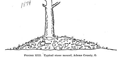
|
The same day a small stone mound was opened upon the farm of John Montgomery one-half mile farther east. A cre- mated skeleton and one much decayed were found in it. It was fourteen by eight feet and two feet high. On the 23d an earth mound three-fourths of a mile northeast of Montgomery's was opened and a hammerstone and decayed bones found. We worked upon Miss McCullough's farm five miles south of Youngsville on the 24th. On her farm are three stone heaps, nine by eleven, seventeen by twenty-one, seven by ten feet. Each was about one foot high. They were upon a high point of land |
|
210 Ohio Arch. and His. Society Publications.
overlooking the west fork of Brush Creek. The bodies, as in the case of all stone graves or mounds, lay upon the surface, had been covered with bark and stones heaped on top. No relics accompanied the remains. Figure XIII is typical of all the Brush Creek Valley stone mounds. On a spur of the same hill, lower down, say 100 feet above the valley, was an earth mound. A few flat stones were scattered over the top. This mound was two feet high and thirty-two feet in diameter. In its center we found a skeleton buried about five feet deep, or three feet below the center of the mound. We could easily trace the excavation for the grave in the hard earth below the mound base. The skeleton was surrounded by large flat stones set on edge and forming a rude sarcophagus, as indicated in figure XIIIa. No relics were with it. We took out the bones |
|
|
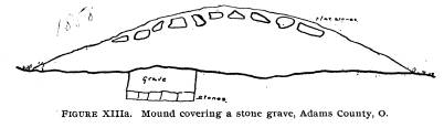
|
for they were splendidly preserved and nearly entire. Length of grave six feet eight inches, width two feet seven inches. All the stones were evenly placed and were about the same size, and the bones were in natural positions. On Thursday, the 25th, we explored a small stone mound on the north side of Brush Creek, opposite the one just described. Nothing but a badly decayed skeleton was found. Some relics were purchased and field searching done over village sites. June 26th we went to Newport, eight miles down the West Fork, where the two Brush Creeks unite and form Big Brush Creek. Mr. Swarington's mound is down stream two and one- half miles from Newport on the lowest terrace 200 yards from the creek. It is of earth containing no stone. Nothing was in it save one arrow-head. As in the case of other mounds, it was thoroughly explored. Upon our return we examined a large village site along the |
Report of Field Work. 211
west border of Brush Creek just below
Newport. It covers
twenty-five acres and must have
contained at least 200 lodges.
There are numerous pottery fragments,
flint chips, bones and
other remains found scattered over the
surface. The pottery is
very peculiar. Men report that some
skeletons in graves have
been found. It is owned by Mr. Plummer.
We dug several
holes without results. Our men in two
hours' field hunting
secured some 300 specimens. We purchased
numerous relics
from boys.
In the afternoon we opened two stone
graves upon Mr.
Plummer's land. They are 400 yards west
of Newport, upon high
ground just opposite each other on the
West Fork of Brush
Creek. Three skeletons occupied each
grave, being placed about
one foot below the surface. A number of
the humeri were pre-
served and part of one cranium.
We sunk a shaft in the Flory mound, but
as it had been
previously excavated in the center,
nothing was found. Situated
upon one of the highest hills in that
region (500 feet) it com-
mands a view of the surrounding country
for ten miles.
June 27th.-On Mr. Patton's farm, two and
one-half miles
southeast of Youngsville, is a small
mound upon the second
terrace. It is four feet high and forty
feet base. In it we found
a decayed skeleton and two rare spear
heads. A layer of char-
coal two inches in thickness was
observed.
June 29th, Monday.-On the Wm. McCormick
farm, four
miles north of Youngsville, are traces
of several graves, but they
have been disturbed. In one of them we
found decayed bones
but nothing else. The stones have
largely been removed by
farmers for foundations, etc.
Near West Fork of Brush, on the same
farm, is a single grave
which we opened and found a badly
preserved skeleton and one
flint war point.
The same day we opened the mound on Mr.
J. William's
farm across Brush Creek from
McCormick's, and distant about
one mile, on a hill of some 175 feet
elevation. There was much
burnt earth and charcoal, a cremated
skeleton and one spear-
head. The mound was four feet high and
forty feet in diameter.
June 30th.-We proceeded to North Liberty
and opened a
212 Ohio Arch. and His. Society Publications.
mound on the farm of Mr. Finley. It is
fifty feet broad and four
feet high, on the second terrace and
composed of earth. After
the examination our hopes were somewhat
raised, for it was the
most interesting structure which we had
examined. Near the
bottom the soil was very dark and soft.
Above this it was lighter
in color, but at no point was it compact
and hard as in the cases
of many of the mounds. On the base near
the west side was a
cremated skeleton, a badly decayed one
lay in the center, a heavy
layer of burnt earth ran along the base
under both the remains.
Above the skeletons were much charcoal
and ashes and also
two fine spear heads of the
"shouldered" pattern. They lay
above the decayed skeleton, while the
boat-shaped ceremonial
lay among the fragments of the
cremation. It was of the form
known as "coffin" or
"canoe" type. Ceremonials of this character
are occasionally found in mounds and but
seldom upon the sur-
face. This may have some bearing upon
their use and should
be carefully noted by all
archaeologists. Above the decayed
skeletons a little over a foot were the
spears, yet we conclude
they were originally intended to
accompany the remains.
Rev. MacLean in his report describes
interesting earthworks
found in Winchester Township of Adams
County.* The works
are a half mile north of the village of
Winchester. We looked at
the mound (which stands over eight feet
high), but did not
attempt exploration, as it had been
previously examined. The
works consist of three small circles and
the mound. MacLean
says of them:
"When first discovered these works
were covered with forest
trees. The walls averaged five feet in
height. The material is
composed of clay of the same kind as
that in the immediate
vicinity. * * * The spot is level and
appears to have been
well chosen." He gives the
measurements as follows:
"First circle 510 feet in
circumference, second circle (oblit-
erated), third circle 150 feet in
diameter."
On the West Fork of Brush Creek, in
Concord Township,
in Highland County, are several mounds,
circles and a peculiar
stone enclosure. The walls are parallel,
distant thirty-two feet,
*J. P. MacLean in Smithsonian Report for
1885, pages 893-899.
Report of Field Work. 213
and 165 feet in length. One end is
rounded and the other seems
to have been filled with earth straight
across from one side to the
other. The walls are not more than a
foot high to-day and at
the time of MacLean's visit were two
feet high. Many of the
stones show the action of fire. Fort
Hill and Serpent mound are
within six or eight miles. We agree with
Mr. MacLean in his
statement:
"It is fair to assume that the
works near Winchester, those
of Eagle Township and the ones just
described belong to the
same people. There is no evidence that
they were constructed
in different ages by different
people."
July 1st.-Mr. Loveberry secured 18
spears from Mr.
lames McNutt, who in clearing a new
piece of ground found
them in a cache or pocket. This happened
but a few days prior
to our arrival, and but for Mr.
Loveberry's efforts the specimens
would have become scattered and lost and
thus an important
cache distributed among those who were
unable to comprehend
its real significance. Mr. McNutt found
them one mile north
of Winchester on a branch of Brush
Creek. With the exception
of two, they are all over six inches in
length, of fine workmanship
and constitute one of the finest
deposits ever discovered.
We went to Tomlinson's ridge, two miles
below Newport on
the East Fork of Brush Creek, and
examined a site on which
graves were said to exist. Careful
cultivation had removed every
trace and we could only find evidences
of a thinly settled and
small village site. We drove along the
East Fork of Brush
Creek for several miles, mapping graves
and sites.
July 2d.-With a view to ascertaining if
there were mounds
in the Sun Fish Hills along the Scioto
Brush Creek, we drove
eighteen miles southeast with six men,
and explored a territory
so rough and rugged that we were
forcibly reminded of our ex-
pedition in Utah. We climbed a number of
hills and ridges 400
to 600 feet high and thoroughly explored
a region four by seven
miles. Having started at four o'clock in
the morning, we worked
until dark and reached home about ten
o'clock. There were but
very few stone graves in the region and
therefore it is to be con-
cluded that the hills offered no
inducements for villages and were
used solely as hunting grounds.
214 Ohio Arch. and His. Society Publications.
July 3.-Graves at Duncansville were
explored. Nothing
was found except decayed bones. These
graves seem to have
been erected by roving bands of hunters,
as they evince no culture
beyond middle savagery.
Dr. Gaston, of Tranquillity, presented
his collection to the
university. We were able to purchase
some interesting speci-
mens. Mr. Morrison, of Newport, also
donated his collection.
July 4th.-Having thoroughly worked upper
Brush Creek
and its tributaries, we decided to
proceed to the Ohio River. Our
route lay through West Union, and all
the way we inquired about
mounds, village sites and collections.
Half way down the stream
we engaged a skiff and set out for the
Ohio.
SECTION 4. MOUNDS ALONG THE OHIO
RIVER.
On July 6th, finding that we could make
better time and
examine the banks on each side to
advantage, we engaged a
river man and his launch for our party.
We worked up and
down from the mouth of Brush Creek on
both sides, digging two
stone graves upon Mr. Monteath's farm.
These graves crowned
the tops of high hills. There was
nothing in them but chips of
flint and decayed bones.
July 7th.-We opened two stone graves and
one mound
on high hills back from the Ohio river
below Brush Creek. All
were of stone, the mound four feet high
and the graves two feet
high. These were on the farm of Mr.
Owens near Concord,
Kentucky. No relics, save two
arrow-heads, could be obtained,
although decayed bones in large
quantities occured in all three.
Undoubtedly these hill top tumili are of
the same character from
Louisville to Pittsburg. They range back
from the river on
either side following tributary streams,
and might roughly be
estimated to cover a belt 100 miles
north and south and 500
miles east and west. It is certain that
scientists can learn noth-
ing more from them and further
explorations of these small
stone structures are unnecessary.
July 8th.-- We located at Rome. It is about 6 miles above
the mouth of Brush Creek in Adams
County. Above and below
it village sites refuse is scattered
over the fields in great pro-
|
Report of Field Work. 215
fusion. Just below Rome, on the high bank of the river, 200 yards from the water, is a mound 2 feet high and 50 feet in diam- eter. In this small structure were found no less than 22 skele- tons, some of which appeared to have been buried in part only. These are omitted from our illustration. Figure XIV, made |
|
|
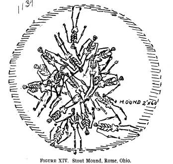
|
from a drawing by Mr. C. E. Cowen, will show them in correct positions. It is in the center of a village site, and while the men dug Mr. Cowen hunted the surrounding lands with profitable results. His collection will be mounted separately in the mu- seum just to show what one man can do in field hunting on a favorable spot in two hours. There were many fragments of pottery in the mounds, but we think the presence of these is due to this fact, that the earth immediately around the village was scooped up to form the mound, consequently much of the village site debris was gath- ered into the baskets and dumped upon the structure. |
216
Ohio Arch. and His. Society Publications.
Perforated mussel shells were with many
of the bodies, a
bone awl and a slate celt polished at
both ends. There were
three arrow heads, three war points and
three worked pieces of
shell. Some 20 perforated humeri were
secured, but no whole
skulls, as every one was broken, as were
most of the long bones.
The vertebral columns of some of the
skeletons were only half
present, which led us to believe that
some of the bodies had been
gathered when the flesh was denuded from
the bones. Possibly
from a battle field, possibly from a
charnel house - who can tell?
The most important find was the bones of
an exceedingly
large individual. These bones were very
badly decayed, but the
tibia was removed in fair shape. The
width of this bone was
nearly two inches in diameter, being
very massive and somewhat
bent. The femura were very large and
more curved than is
usual.
Many pipes and ornaments have been found
around the
mound. It is also historic, for several
pioneers were captured
by Indians at this point and one Captain
Donaldson had a very
hard fight, being in the end captured.
Thursday, July 9th.-- Work having been
completed upon
the Stouts (Rome) mound, we packed and
shipped the speci-
mens and then journeyed to Vanceburg,
Kentucky, the nearest
stopping place. We worked the fields on
the Ohio side. No
mounds of note or promise, and the two
or three in the neigh-
borhood could not be explored.
Friday, July 10th.--The field notes
briefly state: "Bought
relics, hunted fields. Rain prevented
digging, so we journeyed
to Portsmouth."
July 11th and 13th.--Three mounds upon
the farm of Mr.
J. H. Johnson, two miles below
Portsmouth on the Kentucky
side were opened. They were of sand 5 by
40, 3 by 40 and 4 by
35 feet in extent. Small holes had been
sunk in each by pre-
vious diggers. Nothing of note was
discovered. These mounds
are a part of the famous Greenup County
works. The extensive
fortification is but 350 yards up the
Ohio River from them. The
mounds must have been house sites
instead of burial places.
The afternoon of the 13th we went up the
Scioto 5 miles to
Mr. Feurt's farm, where there are three
mounds and an extensive
|
Report of Field Work. 217
village site. We opened the smaller mound and dug the large ones the following day. They are located upon the second ter- race. The small one is 2 by 25 feet, the next 4 by 50 feet, the largest 6 by 60 feet in size.* See Figure XV. The village site must cover at least 5 acres. Many interesting specimens were |
|
|
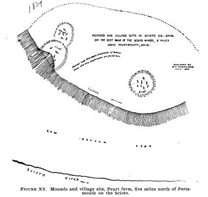
|
collected from it while the men dug, by Cowen, Loveberry and myself. The mounds are all sand and gravel. This is rather unusual. The burials numbered 5 in the smallest, 9 in the next, and 19 in the large one. No relics save mussel shells accompanied the * Mr. Cowen prepared an elaborate drawing from which Figure XV was made. Only the complete skeletons are shown on the diagram. |
218 Ohio Arch. and His. Society Publications.
remains. The pottery of the village site
is very like that found
along the Ohio. We find a difference in
the character of the
pottery after reaching Higbys in Ross
County as one ascends the
river. It may be that all the people
from Higbys or Waverly on
down used different clay, different
forms, or were another tribe.
Future study will determine that.
Mr. Feurt's farm is 5 miles up the
Scioto on the east bank
and seems to have been a remarkable
village site. Field search-
ing resulted in the finding of many
pottery fragments and other
material common to village sites. The
pottery is peculiar to the
lower Scioto and Ohio River valleys.
There is no mica or cop-
per found.
In the mounds there were more burials
above the base line
than upon it, yet the place does not
seem modern, for no Euro-
pean relics were found. Nearly every
skeleton was doubled up,
lay in every direction and several were
on top of each other.
Some were found within 10 inches of the
surface, but this is due
in part to long cultivation lowering the
height of the mounds.
Some war points were found between the
ribs of a skeleton
and several awls and needles lay near
the heads of three skele-
tons. One skeleton was that of an old
man whose teeth were
worn away.
Nine feet below the surface was found
charcoal in the large
mound. This was followed to near the
edges and yielded noth-
ing as usually is the case with charcoal
layers. The excavation
in the large mound was 35 by 20 feet.
There was a layer of ashes
above the charcoal. Sand above this to
top of mound. None
of the others were stratified.
July 15th. -We went to William Biggs's
and inspected an
interesting fortification 4 1-3 miles
above Portsmouth. The fort
is thrown up 4 or 5 feet high. Trench is
4 feet deep. In the
center of the enclosure is a small mound
4 by 45 feet, which we
excavated, finding only burnt earth and
charcoal. The fort is
212 feet in diameter.
July 16th.--We inspected the country
about Wakefield
some 15 miles up the Scioto.
Report of Field Work. 219
SECTION 5. ROSS COUNTY TUMULI.
July 17th.-We moved to Higbys, Ross
County, and opened
the small mound upon the farm of Major
Foster. It was 4 by
40 feet, composed of clay, and on the
second terrace were found
one decayed skeleton and a flint disc.
July 18th.-Opened a mound on Messrs.
Higby's estate on
the first terrace. Just opposite this
mound along the river banks
is a large village site from which much
material has been gath-
ered of late years. Skeletons and whole
pottery have been
washed out. Many bullets have been found
down the river from
the site. Chillicothe collectors have
pipes and other fine relics
from the Higby farm.
The mound was 6 feet high and 60 feet in
diameter. Noth-
ing was found in it though we dug
thoroughly.
The same day we journeyed to Mr. R. L.
Condon's, one mile
south of Omega Station, Pike County, and
opened a mound 5
by 49 by 50 feet. It was a beautiful
structure. We found a cre-
mated skeleton, a decayed skeleton, a
greenstone celt (by the
decayed skeleton) and charcoal.
The next day we visited Mr. J. W.
Barger, who owns a large
mound situated upon the second terrace.
It was 7 by 50 feet. We
excavated it quite completely and
discovered two skeletons. The
bones of one had been painted. By the
remains of the painted
individual were two copper beads and a
copper bracelet. A rude
ceremonial was found with the other one.
All these lay upon the
base line. As in the case of mounds
farther up the Scioto, the
base line was formed by burning the
surface of the ground until
it assumed a brick color and hardness.
Neither Messrs. Condon
nor Barger's mounds were stratified.
During the next day we opened a mound
upon the farm of
Mr. J. C. Corwin, one-half mile on toward
Waverly. There was
in it a cremated skeleton and an
arrow-head, but nothing else.
THE LIBERTY GROUP.
The Liberty group of earthworks,
situated on the banks of
the Scioto, on the second terrace eight
miles south of Chillicothe,
220 Ohio Arch. and His. Society Publications.
constitutes one of the largest and most
important remains of the
Mound Builders.*
It will be seen that the large mound (C)
on Squier and
Davis' plan occupies the most central
position with regard to
the location of the various squares and
circles constituting the
group. It was also the central point of
the village site, and, as
was customary among the mound-building
tribes, the house of
the principal shaman and chief must have
been upon it. Just
a little over a mile above it is the
famous High Banks group and
below it are the mounds about
Richmondale and the large village
sites at Higby's. This region is known
among archaeologists
as the "copper belt." It
extends from central Pickaway County
to the southern edge of Ross along the
Scioto River and up the
two Paint Creeks.
"This work is a very fair type of a
singular series occuring in
the Scioto Valley, - all of which have
the same figures in combi-
nation, although occupying different
positions with respect to
each other, viz. a square and two
circles."+ These figures are
not only accurate squares and perfect
circles, but are in most
cases of corresponding dimensions,- that
is to say, the sides
of each of the squares are ten hundred
and eighty feet in length;
and the diameter of each of the large
and small circles, a fraction
over seventeen hundred and eight hundred
feet, respectively.
Such were the results of surveys made at
different times, the meas-
urements of which correspond within a
few feet. Although in the
progress of investigation singular
coincidences were observed be-
tween these works, yet there was at the
time no suspicion of the
identity which subsequent comparison has
shown to exist.
"The first of the series here
represented is situated on the
east bank of the Scioto River, and
occupies the third bottom or
terrace. The ground upon which it occurs
is level. The walls of
the entire work are unaccompanied by a
ditch, and are slight,
nowhere more than four feet in height.
The embankment of the
square is perceptibly heavier than that
of the small circle, which
* Squier & Davis in Ancient
Monuments of the Mississippi Valley,
plate XX.
+ Ancient Monuments of the Mississippi
Valley, page 56.
Report of Field Work. 221
is also heavier than that of the larger
one. The square work
measured ten hundred and eighty feet
upon each side; and its
walls are interrupted at the corners and
at the middle of each side
by gateways thirty feet in width. The
central gateways are each
covered by a small mound, of about the
same height with the
embankment, and placed forty feet
interior to it. The manner
in which the circular works are
connected with the square en-
closure, and the relative position of
each, are accurately shown
in the plan, precluding the necessity of
a long and intricate de-
scription. It will be observed, that
while the wall of the larger
circle is interrupted by numerous narrow
gateways, that the
smaller one is entire throughout, - a
feature for which it is, of
course, impossible to assign a reason.
Besides the small mounds
at the gateways, there are three others
within the work, two of
which are inconsiderable, while the
other is of the largest size,
being one hundred and sixty feet long,
by not far from twenty
feet high. There are also a few other
mounds outside of the
walls, reference to which is had
elsewhere. Numerous dug holes
occur in the vicinity of the great
mound. Most of these are in-
terior to the work, -- a
very unusual circumstance. In fact, the
whole work appears to have been but
partially finished, or con-
structed in great haste. The mounds at
the gateways, and those
outside of the walls, were formed by
carelessly scooping up the
earth at their base, leaving irregular
pits near them. In most
of the regular works, the material seems
to have been taken up
evenly and with care, or brought from a
distance.
"No one would be apt to ascribe a
defensive origin to this
work, yet it is difficult to conceive
for what other purpose a
structure of such dimensions, embracing
nearly one hundred
acres, could have been designed. The
great mound is anomalous
in its character, and throws no light on
the question. That there
is some hidden significance, in the
first place in the regularity,
and secondly in the arrangement of the
various parts, can hardly
be doubted. Nor can the coincidences
observable between this
and other works of the same series be
wholly accidental."
Having seen the distribution of burial
mounds with refer-
ence to the enclosure, we shall proceed
at once to describe the
oblong Harness mound. This structure was
partly explored
222
Ohio Arch. and His. Society Publications.
by Professor F. W. Putnam. He abandoned
the exploration
after having dug not quite half way
through it, some ten years
ago. We present his report in full at
the end of this section.
Our work upon the mound was begun July
22d and ended
the evening of August 9th. We first
cleaned out the end of the
trench abandoned by Professor Putnam,
and measuring the
mound thence to its end, ascertained the
distance to be about
eighty feet, at least sixty feet of
which should be excavated. We
started in with a trench some thirty
feet in width, being a little
wider than the excavation he had
conducted. We had proceeded
twelve or fifteen feet when we
ascertained that burials followed
each other pretty much the same distance
apart on either side
of the mound, and that there were few
burials in the main or
central portion. Most of the burials in
these rows occupied little
domes or pits, varying from three to
five feet in diameter and
three to five feet in height. The first
five followed each other
with regularity.
We decided to explore the mound by means
of two tunnels,
which should follow the lines of burial,
and, at short distances,
to run side branches from the main
tunnels toward the center,
and, if necessary, toward the edges of
the mound. As the work
proceeded the scheme was found to be
practical and the whole
base of the mound was thoroughly covered
at much less expense
than would have resulted had we
attempted to remove the entire
structure. Some idea of the extent of
the tunnels can be gained
from figure XVI. The total length of
tunnels and branches was
253 feet, the main tunnels 98 feet, the
branches 155 feet. It
occupied the time of from four to five
men continuously for six-
teen days. They were five feet wide at
the base and about four
and one-half feet high.
Nearly all the mounds of the Scioto
Valley are constructed
upon one plan. The ground is first
cleared and then beaten down
and burned until it presents a hard and
even floor. Holes are
dug in this floor at various intervals
and posts inserted and some
sort of structure is erected. Many of
these holes were found in
the Harness mound. In one or two of
them, soft brown and
gray matter, such as results from the
decay of wood, was found.
Just what this structure was cannot be
determined. It seems to
|
Report of Field Work. 223
have been the same in the Oblong mound and Effigy mounds of the Hopewell group, the Porter mound at Frankfort and in the Harness mound of the Liberty group. The post holes do not show any regularity as to position, some being six or seven feet apart, and others as much as twenty feet. In the Harness mound |
|
|
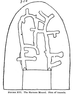
|
several of these holes were found alongside of cremated skele- tons. Every one of them was carefully cleaned out but nothing found. In one or two at the Hopewell group we found ashes and mussel shells. In one (opened 1889) on Mr. Porter's farm at Frankfort, we found ashes and burnt bones, and in 1888, upon the same farm in another mound, we found some pearl beads in one of these post holes. Taken in connection with the burnt |
|
224 Ohio Arch. and His. Society Publications.
floor and the position of skeletons, the posts must have supported a roof some distance above the burnt floor, under which ceremo- nies conducted at the time of the cremation or interment must have taken place. Especially is this true of the large Hopewell mound.* It will be remembered that two altars were found in this mound, one of which contained a large quantity of burned obsidian implements, melted copper, calcined bone, ornaments, tusks, effigy pipes, needles, sacrificial implements, pearl beads and other valuables. These had all been subjected to intense heat. It is just probable that the construction of these, the plac- ing of the copper deposits, may have occupied several days' time and were accomplished with much ceremony. However, we offer this simply as a suggestion based upon field testimony. It is possible that there may be better reasons assigned for the presence of the post holes and the evidence of decayed wood in them. In the end of the mound opened by Professor Putnam a number of entire skeletons were found, accompanied by various objects. In the end which we explored were a total of twenty- seven interments, but two of which were uncremated skeletons, a child and an adult. All the others were more or less burnt. |
|
|
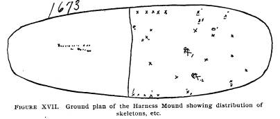
|
In figure XVII all skeletons with which relics were found are numbered, and the brief description accompanying the illustra-
* Called "The Effigy" because of its resemblance to the human trunk and on account of boulder mosaics in the form of panthers (or other animals) found just below the surface in the east end. |
Report of Field Work. 225
tion will acquaint readers with the
find. Skeletons Nos. 4 and 5
had some of the copper objects with
them. No. 10 had the best
copper plate. Eight of the bodies had
objects buried with them.
Every one of these skeletons had been
cremated, and even some
of the beads and copper showed marks of
fire. The total inter-
mentsin the mound numbered 27.
Nearly all the skeletons were on little
raised platforms of
burnt earth, varying in height from four
to ten inches. The
platforms were usually about two by
three feet. Such relics
as accompanied the remains were placed
in no special order and
many of them were partly burnt up. The
looseness of the earth
above the skeletons, or the little domes
to which we have referred,
is probably due to small structures of
poles having been built
about the remains. The supports remained
in position suffi-
ciently long for the earth to become
somewhat packed, and after
their decay just enough earth fell upon
the remains to cover them
loosely. Frequently there was a space of
about a foot between
the top of the dome and the loose earth
below. The good copper
plate found with No. 10 is nine inches
long and five inches
wide. It has two small perforations.
With No. 5 was a burnt
copper plate, three-fourths of which we
took out entire, beads
and bear tusks, etc.
The skeleton uncremated (and placed by
itself) was found
as indicated by No. 12 in Figure XVII.
These individual inter-
ments, at a distance or isolated from
the other burials, are often
observed in the large mounds of the
Scioto.
In the heavy layer of charcoal and
carbonized wood accom-
panying skeletons Nos. 7 and 3, were
fragments of cloth, which
we preserved in order that the texture
and manner of weaving
might be carefully studied.
In this connection it would be advisable
to quote from Squier
and Davis' "Ancient Monuments of
the Mississippi Valley," page
178, as to what discoveries they made
during their partial exam-
ination of the same structure:
"Besides the mounds already
described, the purposes of
which seem pretty clearly indicated,
there are many which will
admit of no classification. Some of them
possess features in
common with all classes, and seem to
have been appropriated to
226 Ohio Arch. and His. Society Publications.
a double purpose; while others, in our
present state of knowledge
concerning them, are entirely
inexplicable. As these mounds
differ individually from each other, it
is of course impossible to
present anything like a general view of
their character. We can,
therefore, only describe a few of the
more remarkable, dismissing
the remainder with the single
observation that their features do
not indicate any specific design, and
are not sufficiently distinct
or uniform to justify or sustain a
classification.
"One of the most singular of these
mounds, and one which
best illustrates the remark that certain
mounds were probably
made to subserve a double purpose, is
situated within a large
enclosure on the east bank of the Scioto
River. It is an irregular
oval in form, and is 160 feet long,
ninety broad at its larger end,
and twenty feet in height. Excavations
were made at the points
indicated in the section. The one
towards the right, or smaller
end of the mound, disclosed an enclosure
of timber, eight feet
square, and similar, in all respects, to
those found in the sepul-
chral mounds, except that, in this
instance, posts eight inches in
diameter had been planted at the outer
corners, as if to sustain the
structure. These posts had been inserted
eighteen inches in the
original level or floor of the mound.
The holes left by their
decay were found filled with decomposed
material; when this
was removed, they exhibited perfect
casts of the timbers. The
casts also of the horizontal timbers
were well retained in the com-
pact earth, and one of the workmen,
without much difficulty, was
enabled to creep more than half the way
around the enclosure
which they had formed. Within this
chamber the earth was as
firm as in any portion of the mound.
Upon removing a portion,
a skeleton partly burned was found, and
with it a thin copper
plate seven inches long and four broad,
perforated with two
small holes; also a large pipe of bold
outline, carved from a dark
compact porphyry. The bones seem to have
been enveloped in
a species of matting, which was too much
decayed to be distinctly
made out. The floor of the mound, it
should be mentioned, so
far as explored, was composed of clay,
was perfectly level, and
had been burned to considerable
hardness.
"The second excavation was made in
the larger end of the
mound, somewhat to one side of the
center, at a spot marked by
Report of Field Work. 227
a depression in the surface. At the
depth of twenty feet was found
an altar of clay of exceeding symmetry.
This was sunk, as shown
in the section, in the general level
floor of the mound, and had
been surrounded by an enclosure in all
respects similar to the one
above described, except that the timbers
had been less in size.
A fine carbonaceous deposit, resembling
burned leaves, was found
within the altar. Amongst the decayed
materials of the sur-
rounding enclosure were found several skewers,
if we may so
term them, in lack of a better name,
made of the bones (ulna) of
the deer. They were finely tapered to a
point, and had evidently
been originally highly polished. Some
were not less than nine
or ten inches long. Though apparently
sound, they were found
to be exceedingly brittle, retaining
little if any of their animal
matter. Drifts were carried in the
course shown in the section,
and the evidences of another enclosure
discovered. The exca-
vation was suspended at this point, in
consequence of heavy and
continued rains. The holes soon became
partly filled by the
caving in of the loose earth near the
surface; which discouraging
circumstance, joined to the extreme
difficulty of digging, pre-
vented a resumption of the
investigation. It is very certain that
another, perhaps several other chambers
are concealed by this
mound.
"The surface of this mound was
covered with the layer of
pebbles and coarse gravel already
mentioned as characterizing
the mounds of the first class; but the
sand strata were absent.
Around the base had been laid, with some
degree of regularity,
a large quantity of flat stones,
constituting a sort of wall for the
better support of the earth. These
stones must have been brought
from the hills, which are here nearly
half a mile distant. Why
the altar, as well as the skeleton, had
been enclosed, and why the
floor of the mound had been so carefully
leveled, cast over with
clay and then hardened by fire, are
questions which will probably
remain unanswered and unexplained unless
future investigations
serve further to elucidate the mystery
of the mounds. At any
rate this singular mound can prove no
greater puzzle to the read-
ers than it has to the authors of these
inquiries."
228 Ohio Arch. and His. Society Publications.
EXTRACTS FROM 18TH AND 19TH ANNUAL
REPORTS OF THE
PEABODY MUSEUM, VOL. III, NOS. 5 AND 6.
"Squier and Davis represent five
small mounds inside the
great square of twenty-seven acres.
These have been leveled by
cultivation, but we could trace the
outlines of three at least, one
of which we thoroughly examined, and
found that it had been
a simple mound of earth thrown up inside
of one of the 'gate-
ways' of the square. Three mounds, one
twice the size of the
others, are represented on the plan as
just outside one of the
'gateways' on the eastern side of the
great circle of forty acres'
area. All three have been much reduced
in height by ploughing
over them, but probably only the
superficial portions have been
disturbed. These three mounds we
examined with care, and
found that the small one to the westward
contained only a small
bed of ashes. The other two proved to be
burial mounds of con-
siderable interest. The human bones were
much decayed. We
found in these mounds various objects
made of copper, stone,
shell and mica, of the same character as
those found in the large
one of the group, consisting of copper
plates, spool-shaped ear
ornaments, a few small ornaments of
copper, one small copper
celt, a crescent-shaped ornament cut out
of slate, another small
stone ornament, a few large beads
covered with copper, and a
smaller one, covered with silver over
the copper, shell beads and
numerous other small articles.
"Another mound in the cornfield,
north of the three above
mentioned, was also dug over completely.
In this we found a
large bed of ashes and charcoal about at
the level of the natural
surface upon which the mound was made.
This ash bed covered
nearly the whole area occupied by the
mound, and in it we found
many fragments of pottery and cut pieces
of mica, some of which
were circular. A large piece of grass
matting and a mass of
burnt seeds, nuts and acorns, were found
in the bed of ashes.
In one place the charcoal matting was in
several layers, making
a thickness of an inch or more. Near the
centre of the mound,
extending to the south, was a long
narrow pit, about 9 x 2 feet,
which was a foot in depth. At the bottom
of this pit were burnt
Report of Field Work. 229
stones, and over them ashes and
charcoal, fragments of pottery
and a few burnt bones.
"Thus it will be seen that the
several mounds connected with
the extensive earthwork were erected for
different purposes and
vary considerably in their structure.
"Near the eastern corner of the
part of the earthwork which
we have called the 'great square,' and
within the line of the cir-
cular embankment forming the 'great
Circle,' stands the largest
mound of the group, which is known as
the 'Edwin Harness
mound.' This mound proved to be of great
interest and unlike
any other mound which we have explored.
It is 160 feet long,
from 80 to 90 feet wide and from 13 to
18 feet high along the cen-
tral portion, which rises gradually from
the southern to the north-
ern part. Up to this time we have made a
thorough exploration
of about one-quarter of the mound, and
have ascertained that
it is a burial mound of a remarkable
character. In the northern
portion, forty feet from the center, we
discovered the first of the
burial chambers, of which we found a
dozen in all. These cham-
bers were made by placing logs, from 5
to 6 inches in diameter,
on the clay which forms the lowest layer
of the mound, in such
a way as to make enclosures 6 to 7 feet
in length and from 2 to 3
in width and about a foot in height. In
these the bodies were
placed, evidently wrapped in garments,
as indicated by the char-
red cloth and mats found in several of
the chambers. With the
bodies were buried various objects, such
as copper plates, ear-
rings, shell beads, and, in one
instance, long knives chipped from
flint. In two instances, the skeletons
were found extended at
full length within the chambers, the
outlines of which could be
traced by the imprint of the logs in the
clay, the logs themselves
having decayed, leaving only a dark
dust. On the breast of one
of the skeletons was a thin copper plate
or ornament. The chem-
ical action of the copper had preserved
the texture of a piece of
finely woven cloth lying between the
plate and the bones of the
chest. In other chambers, the bodies had
been burned on the
spot, as conclusively shown by the
relative positions of the bones
and the fact that, in two instances,
portions of the body had fallen
outside of the fire and escaped burning.
It became evident, as
our exploration progressed, that these
chambers were covered
230
Ohio Arch. and His. Society Publications.
by little mounds of gravel and clay, and
that, in those where the
burning had taken place, the coverings
of earth were placed in
position before the bodies were
consumed, shown by the small
amount of ashes and the reduction of the
logs to charcoal in their
position on the clay floor of the
chamber, which was burned to
a thickness varying with the amount of
heat. It is probable that
the burials and cremations did not all
occur at one time, and that,
after all these mounds had been made,
earth was brought from
various surrounding places and heaped
over all. Then the
mound was finished with a covering of
gravel and a low border
of loose stones was placed around its
base.
"It is of interest to note that
Squier and Davis, in 1840, dug
two pits in this mound. At the bottom of
their pit A, which was
just south of the center of the mound,
they opened one of the
burial chambers, and they state that the
skeleton in it was partly
burned, that it was enclosed in a
framework of logs, and that with
it were a copper plate and a pipe carved
out of stone. They re-
mark that the body seemed to have been
enveloped in matting.
Their pit B was about twenty feet
northwest of the centre and
there they came to another burnt
skeleton, as shown by our ex-
ploration, although, deceived by the
imperfect examination which
the caving of the pit compelled them to
make, they thought they
had found an 'altar' and mention the
burnt burial chamber as
such. They state that they found at this
point several implements
made of bone. At the side of their
excavation we took out about
half a dozen pointed implements made
from the leg bones of deer.
Several months before our work was
begun, as already referred
to, the school boys, under the lead of
Mr. Wilson, dug two pits
in the mound, one of which was between
those made by Squier
and Davis over forty years ago, and the
other at the side of Squier
and Davis' pit B. In each of these many
remarkable objects were
found. So far as 'relics' are concerned,
the boys made a lucky
hit and took out more objects from one
of their pits than were
found in all our exploration. The larger
part of these we have
been able to secure from the boys, and
from Mr. Daniel R. Har-
ness, who very kindly gave to the
Peabody Museum all that he
had purchased from the boys at the time,
realizing that they would
be of more importance and value to
science if placed in the Mu-
Report of Field Work. 231
seum with other objects from the mound,
than if held in private
hands as mere curiosities. Among the
specimens thus obtained
were two copper celts and three or four
copper plates, also several
copper ear ornaments, some of which were
covered with meteoric
iron in the same way as those from the
Turner mounds in the
Little Miami Valley, and a celt made of
meteoric iron. Thus we
have an important link, connecting the
people who built this great
mound and the earthworks about it in the
Scioto Valley, with
the builders of the singular group on
the Turner farm, in the
Little Miami Valley." (Pages
404-406.)
"34856-35134. Burnt human, animal
and bird bones; shells
of different kinds, some of them perforated;
cores and chipped
points of flint; ornaments made of
stone; hammerstone and a
discoidal stone; beads of pearl, bone
and shell; canine teeth of
large bears, some of them perforated;
teeth of deer and a shark's
tooth; ornaments made of copper; ear
ornaments of copper, a
few covered with a thin layer of silver
and others with meteoric
iron; small hemispheres of stone and of
pottery, covered with
silver, copper and meteoric iron;
fragments of silver ornaments;
a celt of meteoric iron and one of
copper; ornaments and frag-
ments of mica; portions of a pipe carved
out of stone; a large
mass of galena; cloth, seeds, nuts, corn
and grass, all charred;
fragments of matting partly burnt; balls
of clay; fragments of
pottery; bone handles, awl points and
other implements of bone;
braided grass; charcoal, ashes and burnt
clay, some of the latter
still bearing the impress of logs of
wood; portions of burnt and
unburnt human skeletons; all from mounds
belonging to the
Liberty group on the land of Edwin
Harkness, Esq., in Liberty
Township, Ross County, Ohio." (Page
426.)
SECTION 6. RELICS OF ANCIENT OHIO TRIBES.
In the descriptions of explorations and
of our journeys down
the various streams, we have purposely
omitted the characteristic
ornaments, weapons, etc., found. These
are to be treated under
this section.
Our collections contain material of
every grade-fine and
poor, high and low. We gathered
everything that related to the
|
232 Ohio Arch. and His. Society Publications. |
|
|
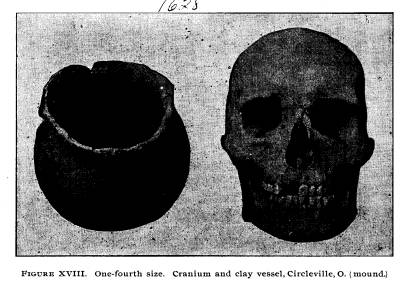
|
pre-Columbian occupation of the region whether by purchase from farmers, by our own field searching and digging, by gift or loan. We are all doubtless familiar with the imposing embank- ments which once occupied the ground now covered by Circle- ville, through the writings of our early antiquarian and historical observers. Not one trace of the high walls of the combined square and circle remains visible to-day. Truly has the oblitera- tion been complete. About two years ago a remaining half of one of the smaller mounds was removed by contractors engaged in grading a new street. In the mound were found the skull and clay vessel illus- trated in Figure XVIII. The skull is remarkably well preserved, brachycephalic in type, was found upon the base line and is there- fore that of an original Mound Builder. It appears to be of the same type as those found throughout Scioto County from Piketon to Columbus. The vessel is not decorated, measures 6 inches high, 51/4 inches across the top, and 19 inches around its greatest circumference. It was moulded in a basket, as the impressions of the strips are plain upon its surface. Mr. Barton Walters, of |
|
Report of Field Work. 233
Circleville, procured the two specimens as soon as they were discovered. On nearly every field in northern Perry County are flint, chert or chalcedony implements and flasks, etc., struck off in their manufacture. Figure XIX presents 19 specimens, each varying in details from the others, yet these may be divided into six classes.
Knives .................. ....... .............. . 6 Rotary or beveled spears ............. ..... .... 2 Scrapers .............................. .... 2 Triangular spears ................. ........ ... 2 Hairpin or drill .............. ...... ... .. 1 indented at base ........... 1 shouldered ............ ...... 1 Barbed implements - stemmed .. .... ... ........ 1 barbed at the side....... . . . 3 No. 3815 is most complete and represents the best type of beveled spear head. No. 3791 is a fine curved knife about 41/4 inches long and well worked on either side. Mr. M. E. Thrailkill, of Columbus, last year loaned the So- ciety his large collection of Scioto Valley specimens. Figure |
|
|
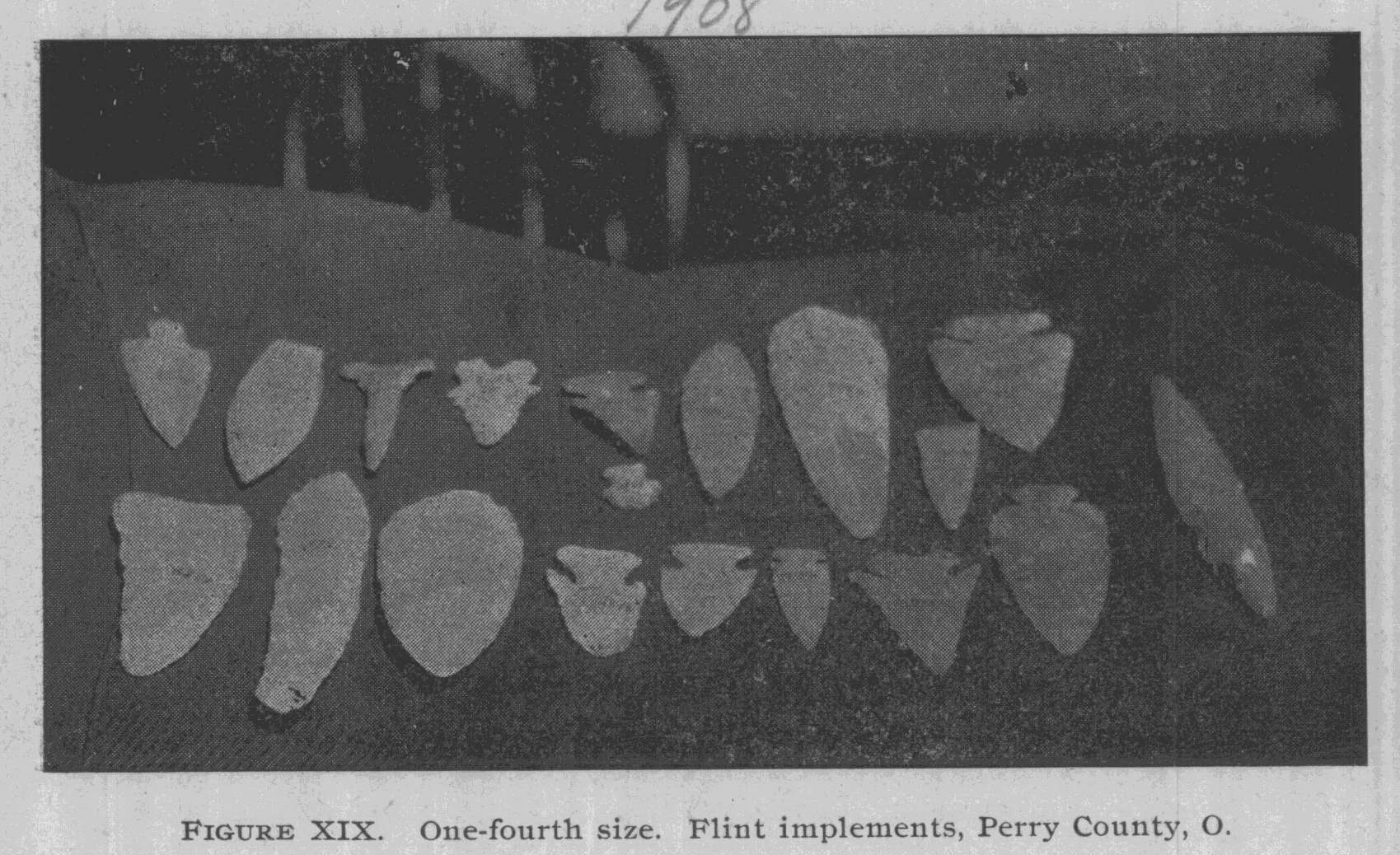
|
234 Ohio Arch. and His. Society Publications. XX shows four hematite pendant or "plum bob" shaped objects and a similar one of slate. The latter is larger and in addition to the girdling groove has one across the top. No one has satis- factorily explained these plummets. Certainly the term "plummet" while it described the form, is unappropriate, and should not find place in archaeological nomenclature. That prehistoric people of this country (at least north of Mexico) knew nothing of the use of the plummet, goes without saying. That these were used as sinkers for fish-lines, as has been suggested by some archaeologists, is beyond belief. |
|
|
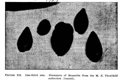
|
An aborigine sufficiently skilful to work hematite into so grace- ful and symmetrical a form, would certainly hesitate about risk- ing the object from his primitive fishing line. An ordinary notched pebble would serve the purpose much better, and could be easily duplicated. Surely the plummet must be ceremonial. Dr. Bowers suggests that they were used as charm stones, basing his conclusions upon the testimony of some aged California In- dians whom he interviewed years ago.*
*See the Antiquarian, January 1897. (Columbus, O., first number.) |
|
Report of Field Work. 235
Figure XXI exhibits five ceremonial and ornamental ob- jects, a tube pipe broadened at one end, and a flat bone handle to a flint knife or other cutting implement. Mr. Thrailkill pro- cured these from a gentleman who had dug in the summit of a mound along the Scioto near the Pickaway County line. He found them a few feet below the surface. Beyond question they constituted a small "cache" which some traveling prehistoric merchant placed in the mound's top that he might more easily discover them. With the specimens illustrated were thirty or forty knives, spear and arrow points. The figure to the left (upper row) in the plate, is a clay pipe and was about seven or eight inches long. Some two inches are missing. It is of an unusual type, called by many persons "tele- scope." The little bone handle lying next to it is about 3 inches long, well made and excellently preserved. None of the tablets, ceremonials and ornaments need description save the one in the lower left hand corner. It is of striped (red and white) granite and rather unique in form. Our museum contains few historic or post-Columbian ob- jects. It is therefore interesting to note that a number of silver |
|
|
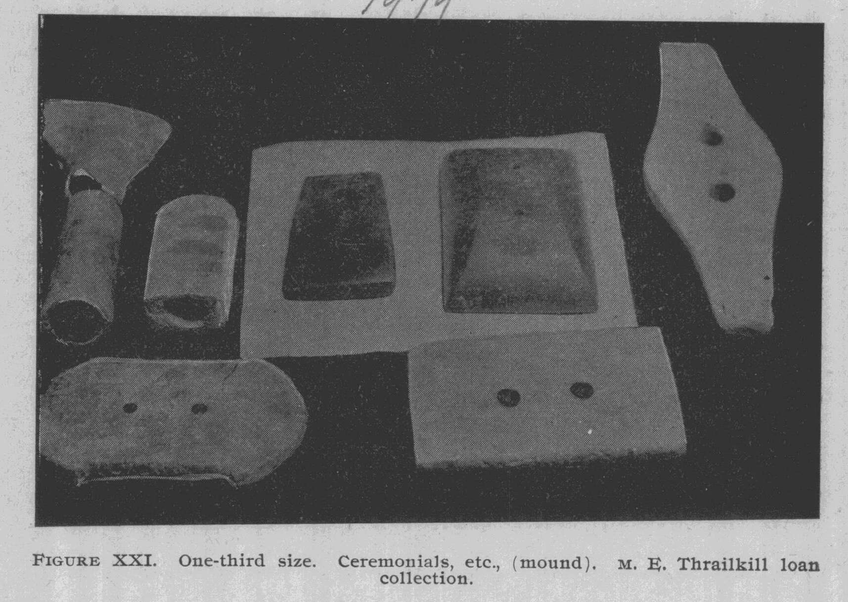
|
236 Ohio Arch. and His. Society Publications. |
|
|
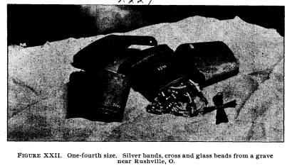
|
arm bands, a thousand beads, some crosses and a kettle were taken from a Delaware or Shawnee grave in Fairfield County just across the Perry County line, south from Rushville. Figure XXII exhibits these. Thousands of Ohio Indians from 1650 to 1800 wore such ornaments, and yet but few have been discovered. Hematite objects are considered scarce among museums. We are fortunate in being possessors of fifty of them. The mu- seum as a whole contains nearly one hundred. Figure XXIII illustrates seven of the best ones secured during the Perry County explorations. The hollow cone to the right is extremely rare. Solid hematite cones are found and occasionally one slightly hol- lowed at the base, but very seldom one such as this. Excepting quartz, there seems to have been no stone more difficult to shape with primitive tools than hematite. Its very hardness would seem to defy the simple artisan; yet he pecked, ground and pol- ished until he reduced the refractory lump to a beautiful plum- met, cone or celt. Any one who studies prehistoric archaeology in America is impressed by the extent of commerce between tribes. Here in Ohio we have slate, hematite and flint, of the latter the greatest quarries in North America. From them (Flint Ridge, Licking County), material in the shape of discs as well as complete im- |
|
Report of Field Work. 237
plements, was transported hundreds of miles. Slate was also widely distributed. Hematite also found its way to remote sec- tions where the material was not to be had. Of course the farther away from its source, the more valuable it became. Most of our hematite comes from the Muskingum region and therefore we had little trouble in greatly enlarging our collection as we traversed Perry, Muskingum and Morgan Counties. Hematite axes are found in Missouri, but seldom in Ohio. Surface ore there exists in large fragments and seems to be bet- ter adapted for large implements. However, the Missouri spec- imens (and there are several in the University collection) do not equal those of Ohio in finish, care in manufacture and polish. It is no exaggeration to state that the combined eastern museums contain at least 2,000 hematite specimens from Ohio. Figure XXIV shows seven of the cache implements from Mr. George Workman's mound, Walhonding. No difference can be detected in the form of these specimens save that some have a nearly straight base, while others are slightly rounded. All are most delicately chipped, being very thin. The minimum size is 2 1-3 inches, the maximum 4 1-5 inches. No 8351 in |
|
|
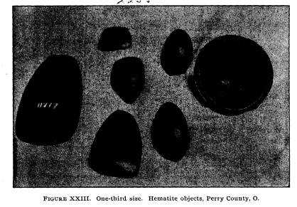
|
238 Ohio Arch. and His. Society Publications. |
|
|
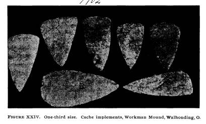
|
the illustration is rather leaf-shaped in outline, while No. 8379 is nearly triangular. Quarries from which chalcedony was mined are distant but a few miles, so the find is local and therefore of great interest The mass of small flakes and chips, cones, etc., lying just a few feet beyond this deposit and the large (decayed) deer antler leads us to conclude that the 67 implements were made on the spot and then placed on the body. We cannot find record of a similar sort of burial in a mound or grave in this country. Triangular spear-heads of the kind shown in Figure XXV, (7896, 8657), we found in four mounds. Invariably they were made of Coshocton flint. No. 8657 came from above Malta, while 7896 was found at the base of the large Porteus mound. These two vary in size, but the form, work and material is the same. Three others found with skeletons are identical, all being very thin, sharp and well wrought. We are inclined to the belief that they were made by the same man, for there is that special- ization or stamp, as it were, which marks them as the handi- work of one person. The mound above Malta is 50 miles, that of Mr. Porteus about 15 miles from the nearest quarries. We are convinced that the tumuli containing these triangular spears were |
|
Report of Field Work. 239
built at the same time, or at least within a few years of each other. (See also figure XXVI.) The central spear in Figure XXV (8659) came from Mr. Alderman's mound at McConnelsville. Two spears, shouldered exactly like this one, of the same size and material, were found in the small Porteus mound below Coshocton. The discoidals shown at the top of the picture are from |
|
|
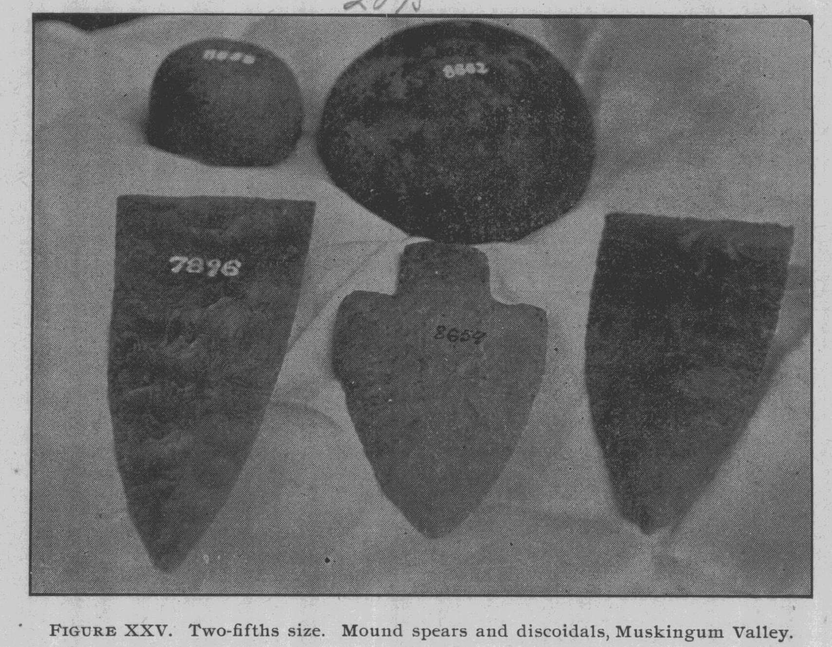
|
mounds; 8662 from Mr. Johnson's, Walhonding, and the small one from a mound three miles above Malta. Discoidals sometimes occur in the tumuli but more frequently come from village sites. The two bone needles or awls shown in figure XXVI come from mounds 75 miles apart: one at McConnelsville and the other near Richmondale. Both are exceedingly sharp and are per- forated. Discoidal No. 3618 (museum number) comes from a vil- |
|
240 Ohio Arch. and His. Society Publications. |
|
|
|
Report of Field Work. 241
lage site near the Sherwood mound above Malta. The trian- gular spear above it has been described on page 196 of this report. Serrated arrow-heads like No. 7101 (museum number) are found along the Muskingum. Most of the large spear-heads (those exceeding 7 inches in length) found in Ohio, have gone to the eastern museums. But we have quite a number preserved in Orton Hall. Figure XXVII exhibits four of them. Beginning at the left we have one of yellow flint, well made but slightly broken at the top. Locality, near the Indiana line in Darke County. Next is a broad speci- men 8x5 inches of quartzite. It is apparently foreign to Ohio yet was found on the site of Logan's (Shawano) town 7 miles southwest of Circleville. The long, shouldered (8� inch) spear comes from Franklin County, banks of the Scioto below Co- lumbus. That beautifully notched one to the right, from near Circleville. (Harness Renick collection). |
|
|
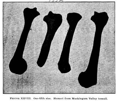
|
242 Ohio Arch. and His. Society Publications. |
|
|
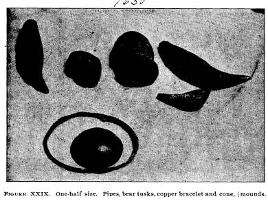
|
Olecranon perforations in the humeri were found in a large proportion of the skeletons exhumed. Of the humeri preserved, perforations were noted in thirty of them. Forty-six were un- perforated. No greater number of humeri, either perforated or unperforated, could be secured, as most of the skeletons found were badly decayed. Figure XXVIII shows one humerus each from four skel- etons. The broken bone is the only unperforated one of the four. In Figure XXIX there are seven objects, each one of which can be classed as a rare specimen. Particularly is this true of the copper bracelet, the hematite cone, and the three bear tusks, all of which come from mounds. It will be observed that the three bear tusks (shown at the top of the plate on either side of the pipes) differ as to size. One has been cut (evenly) and is not perforated. The others have three perforations each. From finds in the Hopewell group, we would conclude that these perforations are made for the purpose of inserting pearls or beads in the side of the tusk, although no beads were found inserted in these specimens. We cannot understand why so many of the bear tusks are cut into two sections. |
|
Report of Field Work. 243
Both of the pipes are of stone and come from the Muskingum valley. The small one from Walhonding and the larger from McConnellsville. The bracelet is from Mr. Barger's mound, the hematite cone and tusks are from the Harness mound, Ross County. |
|
|
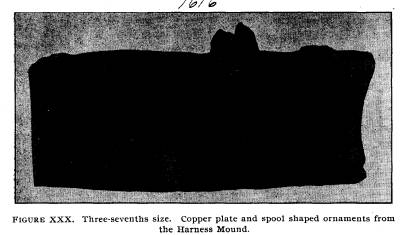
|
Figure XXX exhibits our best copper plate and four spool- shaped ornaments from the Harness mound. All are covered with a heavy incrustation of verdigris and the spools show action |
|
|
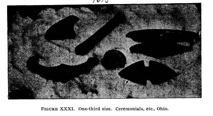
|
244 Ohio Arch. and His. Society Publications. |
|
|
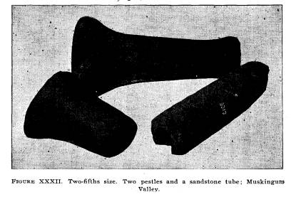
|
of fire. The plate has two perforations. It appears to have been evenly hammered out. Figure XXXI shows seven interesting ceremonials and or- naments of slate in the possession of the Society. Of these, No. 8719 (museum number) was found the past season in Ross County, while the others have been in the possession of the Society for some years. The rude effigy at the top, to the left, is of the type occasionally found in Michigan and the north. It is gen- erally perforated at each end of the base, something after the manner of bird or saddle ceremonials. The crescent-shaped ob- ject, perforated in the middle (lower left hand specimen) comes from Ashland County, Ohio, and was collected by Mr. H. B. Case. It was undoubtedly worn as a head ornament and prob- ably typifies horns. The bar amulet, just over No. 8719, is 7 inches in length, perforated at each end, and seems to have been worn on the fore-arm. The uses of the four objects on the right (the slate "bead," the butterfly-shaped stone, the drilled, pick- shaped object and the boat-shaped) are unknown, and these are covered by the general term, ceremonials. All are interesting specimens and add largely to the attractiveness of the collection. |
|
Report of Field Work. 245
Figure XXXII exhibits two pestles and one large rude tube- pipe. The lower pestle is the more symmetrical and the rarer of the two. The slighter one is a common type in the Mississippi val- ley. No. 3317 (museum number) the drilled sandstone pipe, is 8� inches in length and 2 inches in diameter. It seems to be unfin- ished. Many rude sandstone objects drilled to a depth of from 1 to 3 inches, are found in Ohio, but it does not appear that many of them were used as pipes. On the contrary, it is quite evident that they served as handles for flint or bone tools. We are exceedingly fortunate in possessing a large num- ber of grooved stone axes. Some of these are of rare form and high polish. Especially is this statement true of the middle ax in Figure XXXIII. This plate represents five axes, ranging in weight from three-quarters to nine and a half pounds. Most of the Ohio axes are of the type known as "flat back," that is, the groove does not extend quite around the specimen, the back is either flat or slightly hollowed out, in order that a wedge might be driven between the fastening and the ax head and thus it might be more firmly secured to the handle. Specimens |
|
|
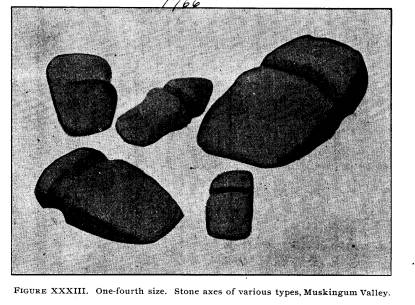
|
246 Ohio Arch. and His. Society Publications. |
|
|
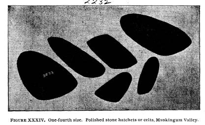
|
like the middle ax, having a round or pointed top and a nar- row, thin, tapering blade, are exceedingly rare and seem to be more of a ceremonial character than for rough usage. Perhaps a larger percentage of axes and polished stone hatchets are found broken than of any of the large relics, because many of them were made of rather inferior stones. We can readily under- stand how that severe blows, such as would naturally result in the processes of cutting down trees, making canoes, quarrying for flint, etc., would cause them to break, or at least, become badly chipped and fractured. Figure XXXIV represents six typical polished stone hatchets or celts of different types. No 3073 (museum number) is oval on one side and flat upon the other. It is highly polished. The speci- men next above it is gouge-shaped, being hollowed out. The next one is sharp at each end, a type exceedingly unusual, while the one at the top is a large symmetrical specimen, yet the common form. Below is shown a chisel and a small common hide dresser. It is doubtless true that many of these polished stone hatchets were lashed in convenient handles and used as tomahawks. They were much lighter and more easily wielded than the stone ax, and the form being wider at the edge readily admits of their being lashed to handles. |
|
Report of Field Work. 247
Plate XXXV represents a number of banded slate orna- ments, the property of the Society. Of these, the T-shaped one in the middle, the heart-shaped specimen (No. 7579, museum number), and the tablet-shaped (No. 4076, museum number), were all found this summer. Undoubtedly those perforated near the top were worn suspended about the neck, for we find them upon the breasts of skeletons in mounds and graves. But those perforated at either end, such as the pointed one at the top, in the illustration, and the one to the right, may have been worn on the forearm and served the double purpose of ornamenta- tion and protection of the wrist against the release of the bow- string. No. 7579, the heart-shaped ornament, is an unique type, not usually found in Ohio. It came from Brinknaven, having been found near the border of Knox County.
SPECIMENS IN THE OHIO STATE UNIVERSITY COLLECTIONS. The Ohio State University has in its collection some very remarkable specimens. Perhaps the finest piece of work in slate is that shown in figure XXXVI. Truly, aboriginal man out- did himself when he manufactured this magnificent ceremonial It is exactly twice the size of the illustration in every particular, |
|
|
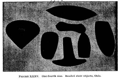
|
248 Ohio Arch. and His. Society Publications.
There is not the slightest flaw in it. It bears unmistakable signs of having been worked either with flint, stone or bone tools. Of the type known as butterfly, or banner stones, we can say |
|
|
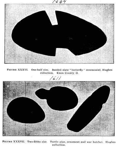
|
naught regarding its use or purpose. Many of our best archaeolo- gists have not attempted to explain the idea that prompted the manufacture of such delicate and unusual types as this. Others |
|
Report of Field Work. 249
have said that they were kept by the chief medicine man or sha- man, in the tribal mystery or medicine bag. Nothing is really known regarding the use of this specimen and we may simply examine it and remark its beauty and perfection. It was col- lected by Judson Hughes of Holmes County, and is a part of his collection now owned by the University. Figure XXXVII shows three more specimens from the Hughes collection. None of them, with the possible exception of the turtle pipe, are like any specimens which we have previ- ously observed in any of the collections from Ohio. Particu- larly would we claim this for the delicate, slender diorite hatchet to the right. It is well chiseled, very sharp, of unusually high polish and fine workmanship. The ornament to the left of the turtle is of banded slate. It differs from other slate ornaments in having a raised section about one-quarter of an inch higher than its regular surface. This is unquestionably an ornament worn about the neck. The turtle pipe is of unique form, al- though the sculpture of the head is not as well executed as in the effigies from the lower Scioto valley. All three of these spec- imens are from Holmes County. Figure XXXVIII shows three specimens from the Mar- shall Anderson collection of Circleville, Ohio. Mr. Anderson's |
|
|
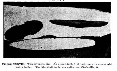
|
250 Ohio Arch. and His. Society Publications. |
|
|
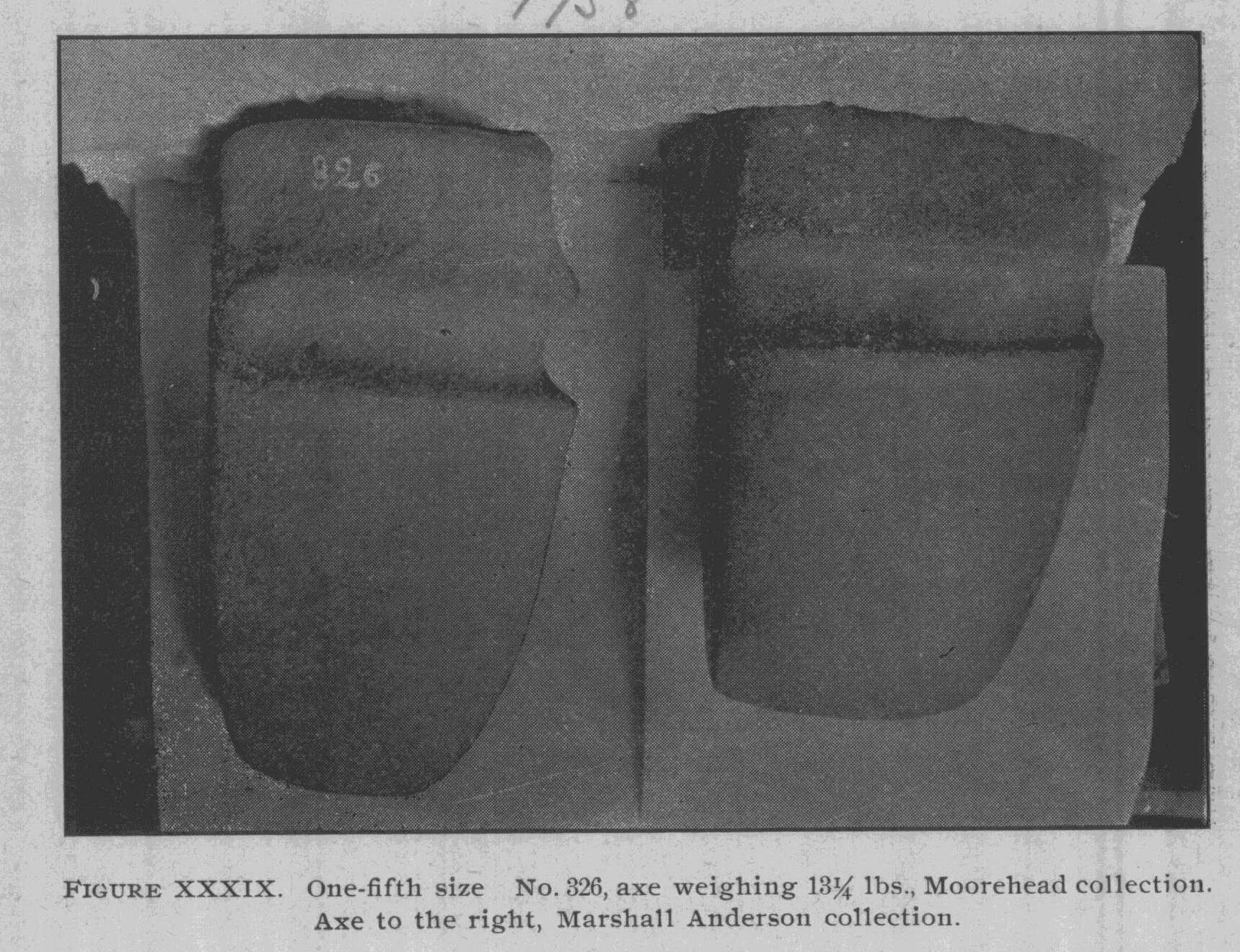
|
widow and son loaned the collection to the University some two years ago. It is valuable in that it comes almost exclusively from Pickaway County. The large flint implement eleven inches in length, shown at the bottom of the picture, is of white flint, and, so far as we are aware, with three exceptions, is the largest flint implement found in the State of Ohio. The exceptions are the chert dagger found at Oregonia, Warren County, Ohio, 1891, by the World's Columbian Exposition survey, un- der our direction; the spear-head of Arkansas material, owned by Mrs. Pricer, near Bainbridge, Ohio, and one implement in the possession of Jacob Ankeney of Xenia, Ohio. The implement is beautifully worked, but slightly nicked upon its edge. The material of which it is made does not seem to be Ohio flint, but we cannot, at present, exactly locate it. It is presumably south- ern. The tablet over the spear is peculiarly grooved in the middle. The pick-shaped ornament is of unusual length and is slightly thickened just opposite the perforation. In figure XXXIX are shown two axes. The one not num- |
|
Report of Field Work. 251
bered belongs to the Marshall Anderson collection. It weighs 10� pounds and is of unusual perfection and polish. Axe No. 326, in the same picture, was found in Warren County, Ohio (the writer's private collection), and weighs 151/4 pounds. It is one of the largest axes in the United States, being excelled by one or two in the Smithsonian Institution, one in Illinois, one in the Field Columbian Museum and one in Wisconsin. Arch- aeologists are rather of the opinion that axes of this great size were made for ceremonial purposes, kept as it were by the tribe for religious or other purposes and were not put to common use. Figure XL illustrates a beautiful tube, an axe and a large slate pipe. The tube and the pipe belong to the Hughes col- lection and were both found in Knox County. The tube is per- forated, as in other specimens of this character, but is unique in that there is a raised section along the middle on either side of the perforation, and, along this elevation, are two grooves. The pipe is quite large, weighing about one pound, and appears to have been used in councils by many smokers, rather than as the property of one individual. The axe is slightly hollowed out on the back, very short and thick, and more of the adze type, |
|
|
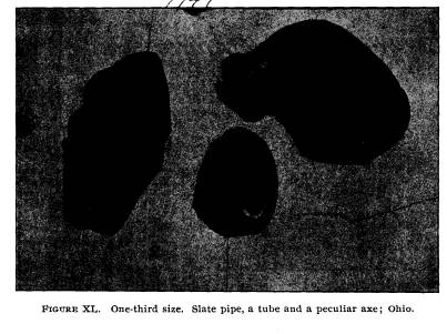
|
252 Ohio Arch. and His. Society Publications.
such as are found on the Pacific coast. It was presented by Dr. Herzer. Figures XLI and XLII represent two of the finest pipes in |
|
|
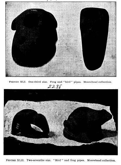
|
Report of Field Work. 253
the museum. These were obtained by the writer, the frog in Warren County and the bird in Ross. At the time of the finding of the bird pipe (No. 593) there was much discussion as to whether it was a bird or a mastodon. The effigy is exceedingly rude and, on that account, some were inclined to believe it to be a mastodon. However, we are of the opinion that it is only a bird. The frog is an excellent sculpture, weighs a trifle over five pounds, and is cut from fine-grained sandstone, while the bird is executed in red standstone. The frog is quite a trav- |
|
|
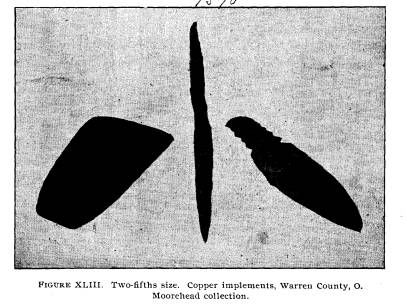
|
eler, having been on exhibition at the Centennial, Philadelphia, '76; the Smithsonian Institution and the Paris Exposition, '89, at which places it received honorable mention. Most of the large effigy pipes have been carried east or abroad, and we may consider ourselves fortunate in having secured several of them.* The three copper relics shown in Figure XLIII come from Warren County, Ohio, and belong to the private collection of
*A large owl pipe, a fox, and a bear are in the University collection. |
|
254 Ohio Arch. and His. Society Publications.
the writer. Quite a number of pieces of copper have been found in Warren County. All of the specimens (an axe to the left, a needle, 842, and a spear-head, 547), are formed of lump copper, hammered in the cold state. In the axe and the spear- head, one can plainly detect the edges of the sheet copper which has been added to thicken the spear through the middle. It may be well to remark in this connection that, while the Field, the Peabody and the Smithsonian Museums and several other in- stitutions have some thousands of specimens of Ohio copper, we have but eighty-four pieces in our entire museum. Figure XLIV shows a sculptured disk, found in the City of Mexico at the time of the Civil war, by Mr. Anderson. Photographs have been sent east to our American scholars, in order that the full meaning of the inscription might be secured. The stone is about an inch in thickness and upon the reverse has three deep holes forming a triangle in the center. Figure XLV represents a terra cotta head found on a village |
|
|
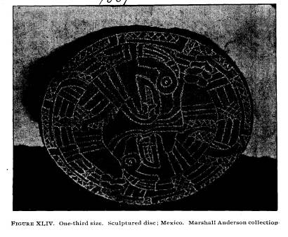
|
Report of Field Work. 255 |
|
|

|
site on the banks of the Ohio River, near Youngstown. It is of the same character as the little idol heads or pottery sculp- ture found in Tennessee and Arkansas.
SUMMARY OF ALL COLLECTIONS IN ORTON HALL ARCHAEOLOGI- CAL MUSEUM, PROPERTY OF THE HISTORICAL SOCIETY AND THE UNIVERSITY. Stone Pestles, various patterns ....................... 192 Rollers, or Elongated Pestles ........................ 47 Grooved Stone Hammers ........................... 92 Ungrooved Hammers, Hammer Stones, etc ........... 510 Grooved Stone Axes, many types .................... 235 Whole Pottery, Missouri, Arkansas, Mexico, Ohio...... 127 Polished Stone Hatchets, or Celts .................... 530 Flint Hatchets, or Small Agricultural Implements...... 305 Exhibit illustrating Southern Village Life, along the Sa- vannah River .................................. 1,306 Slate and Sandstone Tubes .......................... 20 Copper Objects .................................... 78 Ocean Shells, from Mounds .......................... 7 Crania, from Mounds and Graves .................... 32 Saddle Stones (Ceremonials) ......................... 8 |
256 Ohio Arch. and His. Society
Publications.
Ceremonial
Axes and "Butterfly" Ceremonials. ....... 17
Whole or
Partial Skeletons from Mounds .............. 36
*Village Site
Material, Pottery, Flint, Bones, Implements,
etc
......................................
. 6,000
Casts of
famous relics ............................... 115
Bone
Implements from Mounds and Graves........... 198
Shell
Implements from Mounds and Graves ............ 40
Mica Objects from Mounds .......................... 93
Vermont and
Maryland Collection, estimated.......... 1,000
+Flint
Implements, all kinds, estimated ............... 29,585
Flint Ridge
Collection .................... ......... 1,637
Georgia
Collection ................................. 1,018
Stone Mortars
..................................... 16
Stone Pipes
........................................ 51
Clay Pipes
.........................
................ 9
Modern or
Historic Indian Objects ................... 62
Strings of
Beads .................................... 14
Discoidals ........................................ 38
Hematite
Objects ................................... 86
Silver
Objects (Modern) ............................. 12
Slate
Ornaments ................................... 185
Slate
Ceremonials .................................. 80
Granite
Ceremonials, etc ............................ 20
Photographs
of famous relics and of explorations....... 281
Unfinished
Objects ................................. 600
Miscellaneous
Specimens ............................ 1,400
Total
....................................... 46,052
Specimens in
Loan Collections (estimated) ............ 8,900
Total ....................................... 55,052
SECTION 7. AN
ARCHAEOLOGIC MAP OF OHIO.
Two years
ago, at the request of the Society, we undertook
the
preparation of a large archaeologic map of the State of
Ohio. As the
name implies, this map had for its object the
* This
estimate is probably below the actual number in the museum.
+ This number
is probably below the actual.number in the museum.
Report of Field Work. 257
proper recording (by townships) of the
prehistoric mounds, vil-
lage sites, enclosures, fortifications,
etc. The United States Gov-
ernment had observed, through the
Smithsonian Institution and
Bureau of Ethnology Reports, some six or
seven hundred sepa-
rate remains in the State. Butler County
stood alone in this
report as being one of which it could be
said that every monu-
ment (or nearly every one) was
accurately recorded. To Rev.
J. P. McLean belongs the credit of
having done this work many
years before the complete mapping of the
entire area was under-
taken by the Society.
In the making of this map, Ohio stands
as the first State
in the Union which has undertaken
systematic recording of pre-
historic remains. France, England and
Germany know exactly
how many dolmens, menhirs, cairns,
tumuli and fortifications are
within their limits. Governments of
these countries have been
particularly energetic in this matter,
and the archaeologist to-day,
especially of France, is not confronted
with any of the difficulties
which beset the path of the American
scientist. He knows, by
reference to his map, just what mounds,
and how many, are in
each parish.
We were aware, when this work was
projected, that it would
take several years to locate all of the
monuments whose exact
geographic position could be determined.
We estimated that
the number of remains in the State would
reach 17,000. We
were aware of the truth of the general
statement that Ohio is the
richest State, archaeologically
speaking, in the Union; but, as the
work progressed, we were astonished at
the great number and
diversity of these earth and stone
structures.
Many obstacles have arisen and our work
has been carried
on under disadvantages. Nine counties
have reported but one
mound each. Sixteen counties have
reported five mounds, or
less. Our work has proved that there is
no single county in the
State in which there are no prehistoric
monuments. Further-
more, it is contrary to reason to assume
that there are less than
twenty monuments in each county. There
are several sections in
the State in which village sites and
mounds may be extremely
rare, but a careful investigation of
such districts would not fail to
properly record at least fifteen or
twenty evidences of primitive
258
Ohio Arch. and His. Society Publications.
man's occupation. Failure to get any
satisfactory returns from
about forty-five counties in the State
can be charged directly to
those persons with whom we have
corresponded, or conversed,
who are unwilling to take the time and
the trouble necessary to
procure for us a complete report upon
the neighborhoods in
which they reside.
Singular as it may seem, there are
counties in which we
were unable to find any person who was
willing to cooperate
with us. Generally, over the State more
than 100 persons re-
turned our tracings with such comments
as: "I have not time,"
or "How much do I get for
this?" or "Don't know and don't
care," - and these were people of
intelligence.
It may be interesting to readers to
learn how we obtained
the 2843 characters placed upon the map.
We first took all those which Professor
Cyrus Thomas, Mr.
Fowke, Rev. MacLean and a host of other
investigators had
recorded in the various publications.
This covered every report
relative to Ohio available in public and
private libraries at Colum-
bus (something over 400 volumes and
papers). As a total from
these we obtained about 900 locations.
Then we prepared tracings of each of the
counties and sent
these to all collectors and members of
the Historical Society
and persons of intelligence whom we
thought would aid us.
Many of the tracings were lost. Others
came back and were
again sent out. Most of them were
returned with but one or
two markings. Pickaway County may be
taken as an example
of the method pursued. It was first sent
to Mr. Barton Walters,
of Circleville, who recorded 53
monuments, then it went to Mr.
Tipton in the southwestern portion of
the county, who placed
about 25 more, and from him to a
gentleman upon the east side,
who listed such as were known there.
Then it was sent to Mr.
Roof, of northern Pickaway County, who
recorded 15 or 20
more.
It must be remembered that nearly every
location represents
more than one mound and that a large proportion
of the earth-
works include numerous mounds, circles,
squares, etc., so that
the total average for each mark made
upon the map is:
Report of Field Work. 259
41/2 for the Scioto Valley,
21/2 for the Muskingum,
21/2 for the Great Miami,
2 for the Little Miami,
2 for Brush Creek, and
1� for the whole Ohio River from
Steubenville to Cincinnati.
The northern part of the State and hilly
sections will not
average more than 11/4 per
character. As near as we can estimate,
the 2843 marks upon the map represent
6500 monuments.
Of the obliterated mounds, circles and
earthworks, some
can be accurately placed, but there are
doubtless many, espec-
ially in rich, alluvial bottoms of the
Scioto, Muskingum, Hocking
and two Miamis, which have forever
disappeared and have left
no trace behind, either in the memory of
man, or upon the surface.
It will be observed that twenty counties
in the State have fur-
nished nearly all the mounds and that
Butler, Ross, Jackson,
Pickaway, Franklin, Licking, Washington,
Fairfield and Adams
have furnished over 1400, or about
one-half of the entire number
recorded.
The larger portion of them lie south of
the center of the
State. Many cannot be very accurately
located. If these were
recorded, the number would be swelled to
7500, but we have
purposely left them out.
The survey during the past two summers
recorded upwards
of 500 monuments during its travels. Mr.
Swartzel was sent
through the northern part of the State
on a bicycle and visited
seven or eight counties, procuring from
them 50 or 60 monuments.
Mr. Loveberry spent four days in
traversing portions of
Fayette, Pickaway, Madison, Highland and
Ross Counties on
a bicycle and secured a total of 165
additional mounds. Mr. R.
H. Moorehead traveled through northern
Licking County and
secured 48 mounds in two days. Mr.
Loveberry followed Big
Darby Creek on one of his trips and main
Paint Creek upon
another, while Mr. Moorehead followed
the north fork of Licking
River.
The Curator drove from Steubenville
nearly to Clarington
260 Ohio Arch. and His. Society Publications.
in Monroe County, along the Ohio River,
and located about 40
monuments. He drove several days in
Perry, Fairfield and Pick-
away Counties, and while lecturing in
the northern part of the
State, drove across Hardin, Wyandotte,
Seneca and Sandusky
Counties. Pike, Ross, Carroll, Harrison
and Warren Counties
were also traveled by him.
While mounds seem very thick in the
Muskingum and
Scioto Valleys, it must be remembered
that those regions
had been repeatedly traversed by
surveys. We do not claim
that other regions would show as many
remains, but they
would exhibit several hundred more than
is now assigned them
were it possible for a representative of
the Society to visit them.
Brush Creek, previous to this summer,
had but a scant dozen
known remains. White Oak Creek in Brown,
Raccoon Creek
in Gallia, the lower Hocking, Beaver
Creek in Columbiana and
other valleys, if visited, would be
found to contain at least three
or four hundred prehistoric structures.
It is now practically impossible to
secure exact locations,
or any considerable number of additional
monuments by means
of correspondence.
Recently two hundred letters sent out to
persons supposed
to be interested in archaeology with
whom previous correspond-
ence had not been had, resulted in the
acquisition of only twenty
or thirty mounds or village sites.
An examination of the map shows that
many sections of the
State, and especially those enumerated
below, are not fairly rep-
resented. We cannot hope to complete our
map, or at least
to have it approach completion, unless
we resort to personal
visitation.
Because of the difficulty of securing
further testimony by
correspondence (as we have written to
every one in the State
who is interested in archaeology) the
Curator suggests the prac-
ticability of sending, next summer, one
of the students upon a
bicycle from Jefferson in Ashtabula
County south through War-
ren to New Lisbon, west across the State
to Lima, south along
the Great Miami River to Dayton, thence
by rail to New Phila-
delphia, thence southeast to Clarington
in Monroe County, and
Report of Field Work. 261
from there down the Ohio River to
Ironton, thence northeast to
Athens, then to Ashtabula and west along
the lake to the Mau-
mee, up the same to the Indiana line,
and south to Cincinnati.
This would occupy about two months and
would give us an
accurate report upon such regions as
have not been recorded.
The Curator is convinced that the number
of monuments upon
the map would be increased by two or
three thousand by such
personal visitation.
Taken as a whole, the two years' work
upon the map has
been productive of gratifying results.
We have recorded for
archaeologists and persons interested in
science 6500 of the monu-
ments of pre-Columbian times. To
students of the future, the
value of our State archaeological map
can scarcely be overesti-
mated.
No archaeologist seems to have paid
attention to glacial
kame and gravel knoll burials. Our map
shows them to have
been much used as grave sites.
Out of three hundred and ten persons in
the State inter-
ested in archaeology, no one seems to
have ever heard of copper
and but little mica have been found with
skeletons in them.
There is every indication that
interments in glacial kames are
older than the mounds.
Excellent preservation of the skeletons
is not evidence of
recent interment. Bodies buried in
gravel, are well preserved,
because the material surrounding them
permits the water to
readily penetrate below the bones, thus
keeping the bodies dry.
With the exception of some pieces of
pottery and carved
shell, the most crude and primitive form
of ornaments and weap-
ons accompained the skeletons. There is
no care evinced in the
preparation of the graves-no evidence of
ceremonies having
been enacted, such as we conclude were
carried out when the
mounds were constructed. A simple
excavation is made in the
knoll and the bodies deposited,
apparently without any wrap-
pings of hides or cloth. When possible a
rounded knoll-almost
artificial in appearance-was always
chosen. The number of in-
terments ranges from one to fifty. In
Clark, Pickaway, Lick-
ing, Clinton, Clermont, Ross and Hardin
Counties, gravel burials
262 Ohio Arch. and His. Society Publications.
seem most numerous. A circle twenty
miles in diameter with
Circleville as the center would include
more than one hundred
glacial formations in which skeletons
have been found. Nearly
every farmer or county commissioner who
has had any consid-
erable experience in opening pits,
speaks of the finding of skel-
etons, always tolerably well preserved.
In gravel ridges we sometimes observe
trenches varying from
fifty to one hundred feet in length, in
which there are skeletons.
We are inclined to the opinion that
these are not ancient, but
cannot speak with certainty until
further explorations are made.
In one trench near the site of Cornstalk
Town, in the Pickaway
Plains, farmers found thirty-five or
forty skeletons, several of
which showed unmistakable bullet holes
in the skulls.
Some interesting conclusions can already
be drawn from
the map. Fortifications, enclosures,
village sites and mounds
are so numerous in the southern part of
the State that a line
drawn in any direction will intersect
large numbers. This dis-
proves the old assertion, made by our
pioneer archaeologists, that
mounds follow each other at regular
intervals and were used
largely as signal stations. The
distributions of mounds can be
compared to the stars in the heavens,
and lines, circles, squares
or triangles might be drawn so as to
intersect almost any desired
number. While mounds follow the streams
generally, yet there
are many of them in hilly sections.
Nearly every mound can
be truly classed as simply a structure
erected to cover the dead.
Stone mounds predominate over those of
earth along the Ohio
River, upon Brush Creek and throughout
the Muskingum Valley.
It almost appears that we can classify
the mounds of Brush Creek,
the Ohio, the Scioto and the Muskingum
as having been erected
by different tribes. The exact
relationship of these to each other
must be determined by future
investigations, but it seems, now,
as if we could place those of Brush
Creek and the Ohio in greater
antiquity, or at least belonging to a
more primitive culture than
those in the Scioto or the Muskingum. It
is safe to conclude
that in point of numbers, careful
construction and evidence of
a high grade of barbaric culture, the
remains in the Scioto,
especially in Ross and Pickaway
Counties, rank far above those
Report of Field Work. 263
in other portions of the State; and while that culture is high,
yet it must find its true position in upper barbarism and cannot be
considered as belonging to a state of true civilization.
It will be seen in this enumeration, that we have not at-
tempted to make a detailed division of the prehistoric remains in
Ohio into their proper classes. While the map shows the known
remains in each valley, and distinguishes between structures upon
hills and those in the valley, of earth and of stone, of circular,
square and irregular form; an enumeration of these remains ac-
cording to kind, might lead students to arrive at erroneous con-
clusions. In the next annual report, the map shall have been
sufficiently progressed to permit us to state in tabulated form
just what classes of remains predominate in the various sections.
Therefore the present omissions in our table are intentional,
and must needs be overlooked by the critical reader.
TABLE OF PREHISTORIC REMAINS IN OHIO ARRANGED AC-
CORDING TO COUNTIES AND TOWNSHIPS.
ARRANGED ACCORDING TO THE NUMBER CONTAINED.
ROSS.
Colerain ..................... 1 Buckskin .................... 10
Green ....................... 22 Concord ..................... 10
Springfield .................. 13 Deerfield
..................... 4
Liberty ...................... 25 Franklin ..................... 18
Scioto ....................... 22 Jefferson ..................... 10
Huntington .................. 10 Paint ........................ 6
Union ....................... 38
Twin ......................... 25 Total
.................... 231
Paxton ...................... 17
LICKING.
Mary Ann ................... 1 Franklin ..................... 20
Monroe.
.................... 2 Lima ........................ 1
McKean ..................... 5 Washington .................. 9
Jersey ..................... 7 Harrison ..................... 2
St. Albans ................. 13 Union
....................... 14
Eden ....................... 7 Licking ...................... 13
Granville ................. 21 Hanover ..................... 17
Newton ..................... 10 Bowling
Green ................ 15
Newark ..................... 2 Burlington ................... 8
Hopewell ................... 9
Madison ................... 18 Total .................... 212
264 Ohio Arch. and
His. Society Publications.
PICKAWAY.
Salt Creek .................... 7 Muhlenburg
.................. 19
Pickaway .................... 21 Monroe
...................... 12
Perry
................... .... 5 Deer Creek ................... 13
Washington .................. 7 Wayne
....................... 15
Walnut ...................... 21 Darby ....................... 8
Madison
..................... 4 Circleville .................... 8
Scioto ....................... 17
Harrison ..................... 16 Total
.................... 195
Jackson ...................... 22
BUTLER.
Morgan
..................... 10 Wayne
....................... 7
Reilly ..................... 16 Madison
..................... 12
Oxford ...................... 17 Lemon ....................... 4
Milford .................... 6 Liberty ...................... 6
Hanover ..................... 11 Union ....................... 11
Ross ....................... 44
Fairfield .................. 14
Total .................... 183
St. Clair................... 25
JACKSON.
Scioto ....................... 4 Jackson
..................... 5
Madison ..................... 4 Coal
......................... 65
Jefferson ..................... 5 Washington .................. 15
Bloomfield ................... 5
Milton ....................... 7
Franklin ..................... 21
Liberty ...................... 15
Total .................... 152
FAIRFIELD.
Rush Creek .................. 11 Clear
Creek .................. 25
Madison ..................... 5 Violet ........................ 5
Richland ..................... 20 Walnut ...................... 1
Pleasant ..................... 4 Bloom ....................... 13
Berne ........................ 12 Amanda ..................... 15
Hocking ..................... 12
Greenfield .................... 3
Total .................... 126
FRANKLIN.
Perry ........................ 6 Franklin ..................... 7
Sharon ...................... 10 Marion ...................... 8
Blendon .................... 4 Truro
........................ 5
Brown ....................... 2 Pleasant ..................... 10
Clinton ...................... 3 Jackson ...................... 21
Mifflin ....................... 4 Hamilton
.................... 19
Jefferson ..................... 4 Madison
..................... 11
Washington .................. 1
Prairie ....................... 3
Total .................... 118
WASHINGTON.
Windsor ................. .. 3 Marietta
..................... 10
Waterford
.................... 12 Warren
...................... 1
Adams ....................... 35 Salem ........................ 2
Union
....................... 3
Muskingum
.................. 19 Total
.................... 85
Report of Field Work. 265
CLINTON.
Chester ...................... 1 Richland
..................... 1
Liberty
. .............. 4 Clark
........................ 1
Wilson ...................... 1 Union
....................... 42
Washington . ................ 2 Green
........................ 1
Adams . ......
............. 13
Vernon ...................... 11
Total .................... 77
ADAMS.
Winchester .................. 10 Tiffin
........................ 10
Scott . .............. 1 Jefferson ..................... 6
Bratton
...................... 6 Green
........................ 9
Meigs . ............... 10 Monroe ...................... 7
Oliver . .............. 3 Spring ....................... 4
Wayne ..
..................... 5
Liberty ...................... 1
Total .................... 72
MUSKINGUM.
Madison .................. 8 Salt
Creek ................... 2
Cass ............
...... 6 Rich Hill ..................... 3
Hopewell . ............ 9 Newton ................... 1
Licking ...... ............ 4 Harrison
... ................. 2
Muskingum ............... 1 Blue Rock ................. 5
Falls ................... 2 Brush Creek
................ 3
Salem .................. 1 Springfield
........ ...... 10
Washington ............. 7
Union ......
............. 1 Total ................... 70
Wayne ................ 4
PERRY.
Monroe
...................... 1 Madison
..................... 1
Salt Lick . ............ . 2 Hopewell
. ................... 14
Pike . ....
.. .............. 3 Thorn ........................ 28
Reading . ............. 15
Clayton . ........... ... 4 Total ....................68
WARREN.
Wayne . .............. 7 Deerfield
.................... 1
Turtle Creek... ............ 18 Washington
................. 9
Franklin . .................. 5 Harlem
...................... 1
Massie ...................... 2 Hamilton
.................... 4
Union ...................... 7
Clear Creek . .................. 1
Total .................... 55
PIKE.
Benton ...................... 2 Scioto
....................... 9
Berry ........................ 3 Seal
. ....................... 11
Mifflin
....................... 2 Pee Pee .
..................... 11
Sun Fish .................... 1 Jackson
. ..................... 10
Camp Creek .................. 2
Newton
...................... 4 Total
.................... 55
266 Ohio
Arch. and His. Society Publications.
COSHOCTON.
Tiverton ..................... 4 Tuscarawas
.................. 11
New Castle
.................. 8 La Fayette .................... 5
Jefferson ................... 8 Oxford
...................... 3
Bethlehem ................... 7 Pike
.......................... 1
Keene ...................... 1 Franklin ..................... 1
Perry ........................ 1
Jackson ...................... 2 Total
.................... 52
DELAWARE.
Porter ....................... 2 Oxford ...................... 1
Berlin ....................... 1 Brown ...................... 3
Thompson ................... 1 Berkshire ................... 2
Radnor ...................... 4 Orange ...................... 6
Marlborough
................ 1 Genoa ....................... 2
Troy ........................ 3 Harlem ...................... 1
Scioto ....................... 2
Concord ..................... 5 Total
................... 45
Liberty ...................... 11
HARDIN.
Washington .................. 1 McDonald ................... 3
Jackson
...................... 1 Lynn
.......................: 2
Cessna ....................... 7 Buck ........................ 6
Hale
......................... 4 Taylor Creek
................. 3
Pleasant ..................... 6 Dudley ...................... 5
Goshen ..................... 3
Round Head................. 4 Total
.................... 45
ATHENS.
Dover ....................... 4 Trimble
...................... 1
Athens ....................... 11 Ames
........................ 9
Lee
.......................... 1
Rome ....................... 1 Total .................... 44
Alexandria ................... 17
SCIOTO.
Valley ....................... 6 Washington
................. 6
Porter .......................
2 Nile ......................... 6
Clay ............. ...........15 Morgan ...................... 1
Green ........................ 3
Rush ........................ 4 Total
.................... 43
CLARKE.
Bethel
....................... 5 Harmony .................... 7
Springfield ................... 12 Madison ..................... 2
German ...................... 2 Pike
......................... 1
Mansfield .................... 3
Green
............. ........ 4 Total
................... 38
Mad River .................... 2
Report of Field Work. 267
HAMILTON.
Colerain ..................... 2 Anderson
.................... 10
Miami ....................... 3 Spencer ...................... 2
Delta ........................
5 Delhi ........................ 1
Mill Creek ............ ....... 1
Sycamore .................... 3 Total .................... 36
Columbia .................... 9
ASHLAND.
Clear Creek ................... 4 Hanover ..................... 4
Montgomery
................. 7 Lake ........................ 2
Jackson ...................... 1 Green ....................... 10
Mifflin ....................... 2
Mohican ..................... 5 Total .................... 35
BROWN.
Eagle
........................ 1 Union
....................... 14
Jackson ...................... 1 Huntington .................. 4
Jefferson
..................... 3 Lewis ....................... 2
Scott ........................ 1 Perry ........................ 5
Byrd ........................ 2
Pleasant ..................... 2 Total
.................... 35
HIGHLAND.
Paint ........................ 9 Fairfield ..................... 2
Madison ..................... 2 Concord ..................... 8
Clay ......................... 2 Brush Creek
................. 3
Liberty ...................... 2 Jackson ...................... 2
Dodson ...................... 1
White Oak.................. 4 Total
.................... 35
CLERMONT.
Montgomery ................ 2 Ohio
........................ 1
Miami ....................... 5 Pierce ....................... 2
Monroe ....................... 1 Wayne ....................... 5
Stone Lick
................... 5 Tate ........................ 2
Jackson ...................... 4
Williamsburg
................ 1 Total
................... 32
Batavia ...................... 4
MORGAN.
Bloom ....................... 5 Meigsville
..................... 3
Malta
........................ 1 Centre
....................... 3
Morgan ..................... 14 Deerfield
..................... 1
Union ....................... 2
Windsor ..................... 3 Total .................... 32
FULTON.
Clinton ..................... 1 Pike ........................ 6
Gorham ..................... 3 Fulton
................. 2
Franklin .................... 8 Chesterfield ................. 6
York
........................ 2
Dover ....................... 2 Total ................... 31
Swan Creek ................. 1
268 Ohio
Arch. and His. Society Publications.
WAYNE.
Sugar Creek ................. 2 Wooster
..................... 12
Canaan
...................... 1 East Union ................... 2
Congress .................... 2 Franklin
..................... 4
Chester ...................... 3 Salt
Lick .................... 2
Plain ........................ 2
Wayne ...................... 1
Total ................... 31
KNOX.
Jefferson ..................... 3 Morgan
...................... 1
Wayne
....................... 3 Clinton ...................... 1
Morris ...................... 11 Pleasant
..................... 1
Middleburg .................. 3 Butler
....................... 1
Monroe ..................... 1
Union
....................... 4 Total
.................... 30
VINTON.
Elk .......................... 2 Swan
...................... 3
Madison
..................... 5 Richland
..................... 2
Eagle ....................... 6
Brown
....................... 8 Total
.......... ......... 26
MONTGOMERY.
German
..................... 6 Harrison .................... 4
Jackson ..................... 1 Butler
....................... 1
Jefferson ..................... 2 Vanburen ................... 1
Miami
...................... 7
Washington ................. 2
Total ................... 26
Madrid ...................... 2
WYANDOTTE.
Tymochtee
.................. 8 Richland ..................... 1
Crane ........................ 3 Jackson 2
Salem ....................... 8
Pitt ......................... 1 Total
.................... 23
MARION.
Grand
....................... 1 Pleasant ..................... 1
Salt Rock
................... 4 Marion ...................... 4
Green Camp ................. 1 Grand
Prairie ............... 4
Montgomery ................ 1
Prospect .................... 4
Total ................... 23
Richland .................... 3
LAWRENCE.
Hamilton
.................... 5 Rome
........................ 1
Upper ....................... 7
Fayette
...................... 8 Total
................... 23
Union ....................... 2
Report of Field Work. 269
GREENE.
Jefferson
................... 1 Xenia ....................... 10
New Jasper ................. 2 Spring
Valley ................ 3
Cedarville .................. 2 Miami ....................... 2
Beaver Creek ................ 1
Caesar's Creek............... 1
Total .................... 22
FAYETTE.
Marion ...................... 2 Union
....................... 4
Paint
........................ 2 Perry ........................ 5
Jefferson ..................... 3
Wayne ....................... 5 Total
.................... 21
SUMMIT.
Northfield ................... 1 Norton
...................... 1
Boston . ............ . 2 Coventry ..................... 2
Northampton ................ 8
Copley .
...................... 3 Total .................... 20
Portage ...................... 3
MADISON.
Monroe .................... 4 Pleasant
..................... 2
Oak Run
............... 1 Jefferson
..................... 7
Union .................. 2
Darby .
.................. 3 Total .................... 20
Deer Creek................. 1
WILLIAMS.
Northwest .................. 4 Springfield .................. 2
Bridge Water .
............... 1 Brady
....................... 1
Florence .................... 3
St. Joseph .
.................. 7 Total ................... 20
Pulaski
...................... 2
HOCKING.
Falls ......................... 1 Washington
.................. 4
Greene . ..................... 1 Salt
Creek .................... 4
Good Hope . .................. 1 Marion
...................... 1
Starr ....................... 5
Perry
........................ 2 Total
.................... 19
UNION.
Washington .................. 1 Dover
....................... 1
York ........................ 4 Mill
Creek ................... 1
Claibourne . .................. 1 Darby
....................... 4
Liberty . ..................... 1 Jerome
...................... 1
Leesburg .................... 2
Paris ........................ 3 Total
.................... 19
270 Ohio
Arch. and His. Society Publications.
ERIE.
Margaretta .................. 10
Oxford .................... 1
Portland ..................... 4
Perkins ..................... 2
Total .................... 18
M ilan
........................ 1
MIAMI.
Staunton .................... 1 Concord ...................... 2
Newberry ................... 1 Monroe ..................... 3
Washington .................. 3 Bethel
...................... 2
Spring Creek ................. 3
Newton
...................... 2 Total
................... 17
LORAIN.
Sheffield ..................... 6 Brownhelm .................. 1
Brighton ..................... 1 Pittsfield
..................... 1
Elyria ....................... 3
Wellington .................. 4
Total . ............. 16
MORROW.
North Bloomfield ............. 3
Peru
................... 1
Gilead ....................... -
Lincoln
...................... 3 Total
................... 16
Chester ..................... 6
BELMONT.
Pease
........................ 5 York
..... . ............... 2
Pultney ...................... 4
Wood ....................... 4
Total .................... 15
LUCAS.
Adams
....................... 2 Providence
................... 1
Oregon ...................... 11
Springfield
.................. 1 Total
.................... 15
HOLMES.
Washington ................. 2 Monroe ..................... 1
Ripley ....................... 2 Richland
.................... 1
Knox
........................ 7
Paint ........................ 1
Total . ............. 14
HURON.
Ridgefield .................... 3
Clarksfield .................
1
Norwalk ..................... 5
Peru .
....................... 1 Total
.................... 12
Fairfield ..................... 2
Report of Field Work. 271
RICHLAND.
Jackson
...................... 1 Jefferson
..................... 2
Sandusky .................... 1 Worthington
.................' 1
Springfield ................... 1
Madison ..................... 3
Total .................... 12
Miffin ....................... 3
TUSCARAWAS.
Dover ....................... 1 Wayne
....................... 2
Franklin . . . . . . . . . . . .1 Mill
........................ 2
Clay ......................... 4
Warwick .
.................... 2 Total ................... 12
DARKE.
Allen ........................ 2 Harrison
...................... 1
Wabash ...................... 1 Greenville .................... 3
Brown ....................... 1 German
...................... 1
Mississina ................... 1
Washington .................. 1
Total .................... 11
ASHTABULA.
Conneaut .....
.............. 3 Morgan ...................... 1
Ashtabula .................... 2 Rome ....................... 1
Harpersfield ................. 1
Wayne
....................... 3 Total
.................... 11
CUYAHOGA.
Brooklyn .................... 2 Solon
........................ 1
Independence ....
........ 1 Bedford ...................... 3
Orange ...................... 3
Newberg .................... 1
Total .................... 11
JEFFERSON.
Cross Creek ................. 3
Wells ........................ 3 Total
.................... 10
Warren ...................... 4
STARK.
Sugar Creek .................. 1 Nimishillen .................. 1
Bethlehem ................... 2 Perry
........................ 3
Canton ....................... 1
Sandy ....................... 1 Total
.................... 9
DEFIANCE.
Mark
....................... 1 Noble
....................... 2
Milford ...................... 1 Farmer
................. ... 1
Tiffin
........................ 1
Hicksville ................... 1
Total' ................... 9
Adams ....................... 1
272 Ohio Arch. and
His. Society Publications.
MERCER.
Dublin ....................... 3 Marion ...................... 1
Union ....................... 1
Jefferson ..................... 2
Total .................... 9
Recovery .................... 2
PREBLE.
Jefferson ..................... 1 Gasper ....................... 1
Harrison ..................... 1
Twin ........................ 5 Total
.................... 8
CHAMPAIGN.
Mad River .................... 1 Urbana
...................... 2
Jackson ...................... 1 Union ....................... 2
Wayne ...................... 1
Johnson ..................... 1 Total .................... 8
ALLEN.
German ...................... 1 Jackson ...................... 5
Bath ....................... 1 --
Total .................... 7
MEDINA.
Westfield .................... 1 Spencer ...................... 1
Medina ...................... 2
York ........................ 2 Total
.................... 6
WOOD.
Perrysburg ................... 1 Washington
.................. 1
Milton ....................... 1
Plain ........................ 2 Total
.................... 6
Weston ...................... 1
CRAWFORD.
Holmes ...................... 3 Bucyrus
..................... 1
Liberty ...................... 1
Total .................... 5
HARRISON. HANCOCK.
Pleasant ..................... 1
Delaware .................... 1
Franklin ..................... 2 Blanchard
..................... 2
Monroe ..................... 3
Total ................. 5 Total.................... 4
OTTAWA.
AUGLAIZE.
Bay .......................... 2 Logan
....................... 2
Danbury.......... .... 3 Douchouquet ................ 2
Total .................... 5 Total .................... 4
Report of Field Work. 273
LAKE. GEAUGA.
Perry
.................. ..... 2 Russell ...................... 1
Painesville ................... 2 Parkman
..................... 1
Total
.................... 4 Total
.................... 2
SENECA. HENRY.
Eden ........................ 1 Napoleon
.................... 2
Pleasant ..................... 2
TRUMBULL.
Total .................... 3 Framington
.................. 1
Braceville
.................... 1
GALLIA.
Addison ..................... 2
Total .................... 2
Green
........................ 1
LOGAN.
Total
................. .. 3 Brookes
...................... 1
MAHONING. SHELBY.
Austintown
................... 1 Vanburen .................... 1
Youngstown ................. 2 PUTNAM.
Total .................... 3
Blanchard ....................
1
MONROE. MEIGS.
Switzerland .................. 1
Switzerland .................... 1
Scipio .......................
1
Salem
........................ 2
COLUMBIANA.
Total
.................... 3 Liverpool .................... 1
PORTAGE. AUDING.
Palmyra ..................... 2
Auglaize .....................
1
Hiram
....................... 1
VAN WERT.
Total ................... 3 Washington
.................. 1
NOBLE. GUERNSEY.
Olive ........................ 2
Spencer ......................
1
Noble
........................ 1
CARROLL.
Total ................. 3
Perry ....................... 1
SANDUSKY. Total number of symbols.2843
Sandusky .................... 1
York ........................ 1
Along the Ohio River on Ken-
tucky and
West Virginia
Total .................... 2 banks
..................... 41
274 Ohio Arch. and His.
Society Publications.
SUMMARY.
In the entire State
there are (records up to Jan. 30, 1897):
Circles of earth
............................... 143
Squares of earth
........ ..................... 74
Enclosures and
fortifications of earth and stone.. 279
Series or groups of
stone graves ................ 115
Glacial kame or
gravel knoll burials ........... 223
Village sites ................................ 174
Tumuli of earth and
stone ..................... 1835
Total ................................... 2843
WARREN KING
MOOREHEAD.
APPENDIX.*
Total number of
specimens added to the joint collections
since the summary on
page 255 was compiled, 9,500.
Total number of
monuments added to the state archaeologic
map since January 30,
420.
More than 20 mounds
have been explored by Mr. Love-
berry. These will be
described in the annual report of next
year. W. K.
M.
*July 1, 1897.