Ohio History Journal
The OHIO HISTORICAL Quarterly
VOLUME 68 * (NUMBER 2 A P R I L 1 9 5 9
The Survey of the Seven Ranges
By WILLIAM D. PATTISON*
THE AMERICAN RECTANGULAR LAND SURVEY
SYSTEM estab-
lished in the land ordinance of 1785
was first put into effect
in the Seven Ranges of eastern Ohio.
Despite the publication
of important contributions to the
history of Ohio which
have dealt with various aspects of the
Seven Ranges, inter-
esting and significant parts of the
survey story have remained
untold.1
* William D. Pattison is assistant
professor in the department of geography at
the University of California, Los
Angeles. His article is based upon Part II of his
doctoral dissertation, which has been
published in a limited paperback edition by
photo-offset from the original
typewritten copy as Beginnings of the American
Rectangular Land Survey System,
1784-1800 (Department of Geography
Research
Paper No. 50; Chicago: University of Chicago,
1957).
1 Serious inquiry into the origin of the
Seven Ranges dates from Charles Whit-
tlesey's First United States Land
Surveys, 1786 (Western Reserve Historical
Society, Tract No. 71, 1886), a
work greatly improved upon by the following three
publications; A. M. Dyer, "First
Ownership of Ohio Lands," New England His-
torical and Geneaological Register, LXIV (1910), 167-180, 263-282, 356-369, LXV
(1911), 51-62, 139-150, 220-231; C.
E. Sherman, Original Ohio Land Subdivisions
(Columbus, 1925), 38-50; and Benjamin H.
Pershing, "A Surveyor in the Seven
Ranges," Ohio State
Archaeological and Historical Quarterly, XLVI (1937),
257-270. Correspondence and other
important source material were published for
the first time in Archer B. Hulbert, Ohio
in the Time of the Confederation
(Marietta, Ohio, 1918). On the basis of
this material, in part, the story of the
Seven Ranges has been placed in the
context of early Ohio history by Beverley W.
Bond, Jr., in The Foundations of Ohio
(Carl Wittke, ed., The History of the State
of Ohio, I, Columbus, 1941), 252-274. Recently, the survey of
the Seven Ranges
has received attention in Walter
Havighurst, Wilderness for Sale: The Story of
the First Western Land Rush (New York, 1956), 62-88.
116 THE OHIO HISTORICAL QUARTERLY
The land ordinance passed by the old
Continental Congress
in May 1785 was a measure aimed at the
raising of revenue
through the sale of large quantities of
land.2 Members of
congress were persuaded to adopt, in the hope of
increased
income, a system of property location
which required sur-
veyors to divide the land, before
either sale or settlement,
into squares bounded by "lines
running due north and south
and others crossing these at right
angles."3 This was the
heart of the system. This novel plan,
accepted from a com-
mittee report of the preceding year,
apparently owed its
adoption to the successful urging of
two beliefs: one, that
it would be relatively inexpensive to
put into effect, and two,
that it would afford security of title
to purchasers of the land
because of the simple regularity of the
property boundaries
deriving from it. To save money
congress decided to require
only the lines bounding townships, six
miles square, to be
surveyed in the field; on drawings
called plats, lines bounding
square-mile sections within the
townships were to be added
at the office of the board of treasury.
The township bound-
aries were to be run according to true
north and marked on
trees, and their location relative to
watercourses "and other
remarkable and permanent things"
was to be noted, along
with the quality of the lands over
which they passed.
Often overlooked is the fact that, just
as the newly sur-
veyed land was to be made available at
auction in each of
the thirteen states, so thirteen
surveyors were to go west,
one from each state, that they might be
able "to communicate
information to the states for which
they were appointed of
the quality of the lands, and such
other circumstances as
2 The land ordinance resembled, in many
important respects, a land law largely
attributable to Thomas Jefferson which
had failed of passage one year earlier.
The drafting of both laws was prompted
by a hope for the removal of a burdensome
public debt through the sale of lands
which had begun to accumulate in the hands
of the federal government with the
acceptance of Virginia's cession northwest of
the Ohio River in March 1784.
3 The text of the land ordinance of 1785
quoted in this article appears in Clarence
E. Carter, ed., The Territorial
Papers of the United States, Vol. II, The Territory
Northwest of the River Ohio,
1787-1803 (Washington, 1934), 12-18.
THE SURVEY OF THE SEVEN RANGES 117
may direct the citizens in making their
purchases."4 Over
the surveyors congress set the holder
of an office which sur-
vived from the Revolutionary War, that
of geographer of
the United States. The incumbent,
Thomas Hutchins, was
summoned by congress as the time for
passage of the land
ordinance approached.5
The geographer and the surveyors were
to proceed to the
country west of Pennsylvania and
Virginia of which George
Washington had said, "This is the
tract which, from local
position and peculiar advantages, ought
to be first settled in
preference to any other
whatever."6 He had in mind, perhaps
first of all, its accessibility by way
of the Ohio River to
Pittsburgh, which in turn was connected
with Philadelphia
by the Pennsylvania Road. Downstream
from Pittsburgh,
within a few miles of the point where
surveying was scheduled
to begin, was a stockaded outpost built
during the Revolu-
tionary War called Fort McIntosh.
Farther downstream, on
the Virginia side of the river, were
several very small settle-
ments, where aid and comfort, already
being dispensed to
emigrants bound for Kentucky, awaited
the federal surveyors.
The final favorable circumstances were
that the Indians had
largely evacuated this area by 1785,
and that the tribes which
might have insisted on their claims to
the territory -- the
Delawares and the Wyandots -- had
officially yielded those
4 Connecticut Delegates to Governor of
Connecticut, May 27, 1785, in Edmund
C. Burnett, ed., Letters of Members
of the Continental Congress (Washington,
1921-36), VIII, 130-131.
5 During the American Revolution each of
two men was styled "Geographer
to the United States of America":
Simeon De Witt and Thomas Hutchins. After
the war De Witt resigned to become
surveyor general of New York. Notice of
Hutchins' summons to administer
surveying under the new land law appears in
Worthington C. Ford and others, eds., Journals
of the Continental Congress,
1774-1789, Edited from the Original
Records in the Library of Congress (Wash-
ington, 1904-37), XXVIII, 291.
6 Washington,
who had viewed the Ohio country from the Ohio River in 1770,
was particularly concerned about the
settlement of veterans of the Revolution when
he ventured this opinion. See Washington
to President of Congress, June 17, 1783,
in John C. Fitzpatrick, ed., The
Writings of George Washington from the Original
Manuscript Sources, 1745-1799 (Washington, 1931-44), XXVII, 17.
118
THE OHIO HISTORICAL QUARTERLY
claims in a treaty signed at Fort
McIntosh in January 1785.7
Not everything was promising about the
country contem-
plated for survey. The land itself,
representing an extension
beyond the Ohio River of the Allegheny
Plateau, was un-
usually rugged. The military strength
concentrated at Fort
McIntosh was slight. Troops stationed
there fell below one
hundred in number during the summer
following passage
of the land ordinance, as expected
reinforcements of militia
failed to arrive and as many of the
men, "for want of con-
fidence in the public treasury
respecting pay," declined to
re-enlist.8 Settlers downstream from
the fort, furthermore,
had not all obediently stayed on the
Virginia side of the Ohio;
those who had made their homes on the
federal side were
under congressional ban and subject to
forcible ejectment.
They, of course, had no reason for
friendly feeling toward
the surveyors.9 Further
afield, the friendship of the Dela-
wares and Wyandots, upon which reliance
was placed after
the treaty of Fort McIntosh, should
have been very little
depended upon. As Hutchins and his men
were soon to
discover, these two tribes could
withstand neither the pressure
of the hostile Miamis and Shawnees, nor
the influence of
the British at Detroit.
Congress, with an appreciation of some
of the difficulties
in store, none the less anticipated a
rapid advancement of
survey work at the time the land
ordinance was passed.
A specific beginning point was
designated in the ordinance,
and, though Hutchins and his men were
going to be obliged
to wait for others to establish it on
the ground, no delay
7 This treaty, a well-known early
landmark in the federal policy of piecemeal
acquisition of territory from the
Indians, confined the Wyandots and Delawares to
a broad zone along Lake Erie, from the
Cuyahoga to the Maumee. Its signing
cleared the way for passage of the land
ordinance of 1785 by freeing a specific
area for survey and sale.
8 See correspondence of Colonel Josiah
Harmar, commandant at Fort McIntosh,
August 1784-June 1785, in Consul W.
Butterfield, ed., Journal of Captain Jonathan
Heart . . . to Which Is Added the
Dickinson-Harmar Correspondence of 1784-5
(Albany, N. Y., 1885), 46-74.
9 On these Ohio pioneers who lived in
defiance of federal authority, see Randolph
C. Downes, "Ohio's Squatter
Governor: William Hogland of Hoglandstown,"
Ohio Archaeological and Historical
Quarterly, XLIII (1934), 274-275.
THE SURVEY OF THE SEVEN RANGES 119
was anticipated as a result. But it was
in this connection
that the first of many delays
developed. The federal sur-
veyors were to start off westward from
the north, or right,
bank of the Ohio River at the point
where Pennsylvania's
western boundary intersected it--just
as soon as that bound-
ary had been run. The southwestern
corner of Pennsylvania
had been established in 1784, and the
boundary commis-
sioners of Virginia and Pennsylvania
had agreed to meet
there in the middle of May 1785 to run
a line due north to
the Ohio River; but they were unable to
convene until early
in June, and it was not until August 20
that they reached the
Ohio River.10 On that same
day field hands were sent across
to "set a stake on the flat, the
North Side of the River."11
Many miles of the Pennsylvania boundary
remained to be
run northward, but public land survey
by the United States
could now begin.
The summer of 1785 was nearly gone when
the geographer,
Thomas Hutchins, arrived in Pittsburgh
from New York.
Receiving an assurance from Colonel
Josiah Harmar, com-
mandant at Fort McIntosh, that
surveying could be safely
undertaken, Hutchins joined several
surveyors who had been
in the village for a week or more in
"engaging Chain Car-
riers, purchasing provisions, and
Buying Horses etc." This
was on September 4. Within two weeks a
general movement
down the Ohio River to an encampment at
the mouth of
Little Beaver Creek was under way.12
Thomas Hutchins was distinguished from
the surveyors
who accompanied him down the Ohio by
more than the fact
that he was head of an executive agency
of the national
10 For a first-hand account of the
surveying expedition which brought Pennsyl-
vania's western boundary up to the Ohio
River in the summer of 1785, see the
journal and letters of Andrew Ellicott
in Catherine V. C. Mathews, Andrew
Ellicott, His Life and Letters (New York, 1908), 40-46.
11 Entry for August 20, 1785, in the
journal of one of the boundary surveyors,
Andrew Porter, in William A. Porter,
"A Sketch of the Life of General Andrew
Porter," Pennsylvania Magazine
of History and Biography, IV (1880), 268.
12 Hutchins to President of Congress,
September 15, November 24, 1785. Papers
of the Continental Congress, No. 60, pp.
189-191, 193-200, Record Group 11,
National Archives.
120
THE OHIO HISTORICAL QUARTERLY
government known as the
"Geographer's Department."
Earlier in his life, as a British
officer, he had served at Fort
Pitt, and had undertaken exploratory
expeditions from that
point northward to Lake Erie, overland
to Lake Michigan
and the upper Wabash Valley, and down
the Ohio River
to the Mississippi.13 A general map of the West which he
compiled largely on the basis of these
expeditions had estab-
lished Hutchins as an authority on the
area. It served in
the present instance as the surveyors'
guide to the country
they were about to enter.14
Thirteen surveyors accepted
appointments to serve under
the geographer in response to
invitations sent out by congress
during the summer. But of these
representatives of the
several states, one fell ill, one
stayed at home--due probably
to a doubt that his services would be
needed that year--and
three failed to appear for reasons
unknown.15 The eight
surveyors who reported for duty in the
West were Edward
Dowse for New Hampshire, Benjamin
Tupper for Massa-
chusetts, Isaac Sherman for
Connecticut, Absalom Martin
for New Jersey, William W. Morris for
New York, Alex-
13 Hutchins, born in Monmouth County, New Jersey, in 1730, was an officer
in the British colonial service
beginning in 1756. After serving at Fort Pitt, Fort
Chartres, and Pensacola, Florida, he
sailed for England in 1777. In 1778 he deserted
the British service, departing secretly
from London and finding his way at length
back to America, where his services were
welcomed by the Continental Congress.
Anna M. Quattrocchi, "Thomas
Hutchins, 1730-1789" (unpublished doctoral
dissertation, University of Pittsburgh,
1944), 1-208.
14 Hutchins'
map, A New Map of the Western Part of Virginia, Pennsylvania,
Maryland and North Carolina, may be found in Thomas Hutchins, A Topographi-
cal Description of Virginia,
Pennsylvania, Maryland and North Carolina, edited
by Frederick C. Hicks (Cleveland, 1904).
The extended biographical note in this
work has been superseded by the
dissertation of Miss Quattrocchi, cited above.
15 The five appointees who failed to
appear for service in the West were Caleb
Harris of Rhode Island, Adam Hoops of
Pennsylvania, Mark McCall of Delaware,
Absalom Tatom of North Carolina, and
William Tate of South Carolina. Notices
of their election appear in Journals
of the Continental Congress, XXVIII, 398,
XXIX, 539-540. Their letters of
acceptance are in Papers of the Continental Con-
gress, No. 78, Vol, 12, p. 403, Vol. 16,
p. 459, Vol. 18, p. 561, Vol. 22, pp. 305-306.
It was Harris who fell ill (ibid., No
78, Vol. 12, p. 356), and Hoops who seemed
to believe that no surveying would
occur. Hoops to Hutchins, April 30, 1786.
Thomas Hutchins Papers, Historical
Society of Pennsylvania, Philadelphia.
THE SURVEY OF THE SEVEN RANGES 121
ander Parker for Virginia, James
Simpson for Maryland,
and Robert Johnston for Georgia.16
Of the first four of these surveyors,
in the order named,
Dowse alone was a man of minor
importance.17 Tupper was
a general recently retired from the
Continental Army and
a close friend of Rufus Putnam,18 Isaac
Sherman was the
son of the influential Roger Sherman,
to whom credit is
often given for the success of
Connecticut's claim to the
Western Reserve,19 and
Absalom Martin represented the
interests of prominent men in New
Jersey and enjoyed the
recommendation of the governor of the
state.20 All three of
these men were, in fact, harbingers of
great colonization
movements. Tupper was the first of a
series of advance
scouts who acted on behalf of the Ohio
Company of Asso-
ciates. The young Sherman, though he
may not have gone
west primarily to gather intelligence
concerning Western
Reserve lands, addressed a letter on
that subject to the
16 Statements of expense submitted by
most of the surveyors who came west in
1785 may be found in Papers of the
Continental Congress, No. 41, Vol. 4, pp. 305,
307, 309, 315, 317, 319. For other
evidence of the presence of the men named, see
Hutchins to President of Congress,
September 15, 1785, ibid., No. 60, pp. 189-191;
and "Journal of General
Butler," The Olden Time, II (1847), 435.
17 Dowse, an obscure surveyor who had been "lately in the western
country,"
was accepted only after Nathaniel Adams
and Ebenezer Sullivan, both prominent
citizens of New Hampshire, declined the
appointment. Papers of the Continental
Congress, No. 77, Vol. 1, p. 461; New
Hampshire Delegates to President of New
Hampshire, May 29, July 24, 1785, in
Burnett, Letters of Members, VIII, 130-
131, 169.
18 Putnam,
the original congressional appointee (Journals of the Continental
Congress, XVIII, 398), having already accepted the post of
surveyor general for
Massachusetts lands in Maine, sent
Tupper to the Ohio country as his substitute.
Putnam to Congress, June 11, 1785,
Papers of the Continental Congress, No. 56,
p. 161; Rufus King to Henry Knox, June
27, 1785, in Burnett, Letters of Mem-
bers, VIII, 153.
19 The young Sherman, who had retired
from the Continental Army with the
rank of lieutenant colonel, followed his
father's precedent in practicing surveying.
E. D. Kingman, "Roger Sherman,
Colonial Surveyor," Civil Engineering, X
(1940), 514-515. As a federal surveyor
he was second-choice to General Samuel
Holden Parsons. Journals of the
Continental Congress, XXIX, 542.
20 William Patterson, James Ewing, and
others, to Congress, May 19, 1785,
Papers of the Continental Congress, No.
42, Vol. 5, p. 327; Gov. W. L. Livingston
to Thomas Hutchins, May 18, 1785,
Hutchins Papers. Martin, who had been a
captain in the Continental Army, was the
first and only appointee for New Jersey.
Journals of the Continental Congress,
XXVIII, 466.
122
THE OHIO HISTORICAL QUARTERLY
governor of Connecticut before
completing his tour of duty
as a federal surveyor.21 In
the appointment of Martin we
can recognize an early expression of
interest in western lands
on the part of New Jersey speculators
which culminated a
few years later in the acquisition by
Judge John Cleves
Symmes and associates of that large
tract in the southwest
corner of present-day Ohio known as the
Miami Purchase.
The remaining four from among the
surveyors who went
west in 1785 deserve attention more for
their individual
attributes and activities than for
their significance as repre-
sentatives of states or special groups.
Morris of New York,
a young man apparently seeking
employment appropriate to
his technical training, was the single
surveyor who could
participate as an equal with Hutchins
in what the latter
called "the Astronomical business
of the Geographer's De-
partment." And he gained the
geographer's special com-
mendation for assistance in the field
work of 1785.22 Parker
of Virginia appears to have belonged to
that class of woods-
wise men to whose independent surveying
activities Virginia
already owed the subdivision of much of
its own territory.23
Simpson, though a representative of
Maryland, was a sur-
veyor from York County, Pennsylvania.24
It was through
him that the party of federal surveyors
made their only
known contact with the men occupied in
laying out Penn-
sylvania's boundary north of the Ohio
River. He visited
the camp of the Pennsylvania
commissioners early in October
21 Sherman
to Governor of Connecticut, December 31, 1787, in New York
Journal and Weekly Register, May 1, 1788 (handwritten copy by C. A. Burton in
Miscellaneous Collection, Western Reserve
Historical Society, Cleveland, Ohio).
22 Hutchins to Congress, December 27, 1785. Papers of the
Continental Con-
gress, No. 60, p. 225. For the
appointment of Morris, a former lieutenant in the
Continental Army and a subsequent
applicant (in 1789) for the post of geographer,
see Journals of the Continental
Congress, XXVIII, 398.
23 On the deportment of Parker, formerly
a captain in the Continental Army,
see "Journal of General
Butler," 435. His appointment is noticed in Journals of
the Continental Congress, XXVIII, 398.
24 For Simpson's appointment, see ibid.;
for his place of residence, see the entry
for December 3, 1786, in the Journal of
John Mathews, Marietta College Library,
Marietta, Ohio.
THE SURVEY OF THE SEVEN RANGES 123
1785.25 Johnston, a doctor and resident
of Baltimore, who
managed to join in the surveying as a
representative of
Georgia, was apparently a man of means
looking for land
in which to invest personally. Nearly
eighteen square miles
of land in the Seven Ranges were later
purchased in his
name.26
By September 30, Hutchins, his eight
surveyors, and a
retinue of about thirty helpers were
all assembled at the
mouth of Little Beaver Creek, within
easy walking distance
of the scheduled initial point of
survey. A visitor in camp
expected them to progress rapidly with
their work, yet he
found cause for misgiving. Hutchins was
openly apprehen-
sive of Indian hostility, expressing
himself as disposed to
"instantly quit the business"
if danger threatened.27
Hutchins made a beginning on September
30 at the post
on the north bank of the Ohio River set
up by the state
boundary commissioners somewhat more
than a month
earlier. Acting on his instructions in
the land ordinance to
attend personally to the running of the
first east and west
line, he proceeded westward until
October 8, when, having
surveyed less than four miles, he
suspended operations due
to the receipt of "disagreeable
intelligence" concerning the
Indians.28 Though the fact
was not yet apparent, the season's
surveying had come to an end.
The intelligence which reached Hutchins
told of an Indian
depredation at "Tuscarawas,"
a Delaware village located
about fifty miles west of the beginning
point. At a trading
post near the village, according to the
report, two traders
had been set upon by a band of Indians,
who left behind
25 Hutchins
to President of Congress, November 24, 1785, Enclosure No. 1.
Papers of the Continental Congress, No.
66, pp. 201-204.
26 On
Johnston's appointment and place of residence, see Journals of the Conti-
nental Congress, XXVIII, 466; Johnston to Congress, October 27, 1785,
Papers of
the Continental Congress, No. 41, Vol.
4, p. 319. Record of purchase by a "Doctr.
Robt. Johnston" appears in Schedule
of Sales of Lands in the Western Territory
of the United States, Papers of the
Continental Congress, No. 59, Vol. 3, p. 137.
27 "Journal of General
Butler," 435.
28 Hutchins
to President of Congress, November 24, 1785. Papers of the Conti-
nental Congress, No. 60, pp. 193-200.
124
THE OHIO HISTORICAL QUARTERLY
them all the signs of war.29 Hearing
this, Hutchins super-
vised the shifting of the surveyors'
camp to a safer site on
the south side of the Ohio; yet hope
remained that chiefs of
the Delawares and Wyandots would
consent to come and
attend the surveyors at their work,
thereby guaranteeing
their safety. Hutchins had dispatched a
messenger to these
two tribes in the second week of
September, but it was not
until October 15 that a letter of
response, "spoken by Captain
Pipe," was received.30 More
apologetic than threatening in
tone, it simply declined the
invitation. Hutchins, who had
placed the greatest reliance upon the
chiefs, prepared almost
at once to decamp, and within a few
days the entire survey
company had returned to Pittsburgh,
where field hands,
recruited earlier in that village, were
paid off and discharged.
It might seem strange that the troops
at Fort McIntosh,
who had been expected by congress to
protect the surveyors,
were of no help on this occasion. This
lack of support was
due in part to the reduced strength of
the garrison. Unfor-
tunately, the few remaining troops were
needed at the site
of a prospective treaty conference with
the Shawnees farther
down the Ohio River. On the day before
surveying began,
all of the infantry based at Fort
McIntosh had floated past
the surveyors' camp on their way
downstream to the treaty
grounds.31
Having returned to Pittsburgh about one
month after set-
ting forth for the field of survey, the
frustrated surveyors
started home, traveling once more the
Pennsylvania Road,
with nothing but debts to show for
their time and trouble.
Last to depart was Thomas Hutchins,
who, upon arriving in
New York, submitted a map to congress
showing the country
along the few miles of line surveyed.
Perhaps in an attempt
to give congress a sense of value
received for money expended,
29 Ibid., Enclosure No. 1, pp.
201-204.
30 Ibid., Enclosure No. 2, pp. 209-212.
31 The treaty grounds were at the mouth of the Great Miami River, where
the treaty of Fort Finney was signed
four months after this date. The passing-by
of the troops is noted in "Journal of General Butler," 434.
THE SURVEY OF THE SEVEN RANGES 125
he tendered with the map an unusually
copious verbal descrip-
tion.32
Despite the inconsequential nature of
this first attempt
at surveying under the land ordinance,
congress had not yet
lost faith in the enterprise. Hutchins
was given, in effect,
a vote of confidence when in May 1786
congress passed a
resolution authorizing the geographer
to try again.33
By the time of the geographer's return
to Pittsburgh in
June 1786, a new military outpost, Fort
Harmar, had been
constructed at the mouth of the
Muskingum River, the treaty
conference with the Shawnees had been
brought to a seem-
ingly successful conclusion, and the
Wyandots and Dela-
wares, who had attended the conference,
appeared to be
resigned to the survey of their ceded
lands. Prospects for
surveying were further brightened by
Hutchins' success in
dispatching an invitation to chiefs of
the Delawares and
Wyandots nearly three months in advance
of the schedule
of the preceding year.
Thirteen ranges of townships, Hutchins
now expected,
would be surveyed by the end of the
season. He seemed
justified in this hope for at least
three reasons. First, the
potential extent of each range had been
greatly curtailed by
congress. The resolution which had
authorized the resump-
tion of field work ordered that
surveying be confined to the
area south of the east-west line which
Hutchins had begun
to lay out in 1785.34
Second, the prospective work involved
in surveying had been greatly
simplified by the repeal of the
requirement that township boundaries be
run "by the true
meridian," that is, according to
true north.35 Third, Hutchins
had been led to expect that thirteen
surveyors, one for each
32 Hutchins to President of Congress,
December 27, 1785. Papers of the Conti-
nental Congress, No. 60, pp. 225-236.
Nearly all of Hutchins' description is re-
produced in Hulbert, Ohio in the Time
of the Confederation, 130-137.
33 Resolution of May 9, 1786, in Journals
of the Continental Congress, XXX, 248.
34 Ibid.
35 Resolution of May 12, 1786, ibid.,
252.
126
THE OHIO HISTORICAL QUARTERLY
range of townships, would come west in
this year of renewed
effort.36
As the surveyors arrived in Pittsburgh,
they once more
undertook purchasing provisions and hiring field
parties.
When preparations were complete, each
of the states but
Delaware was represented by a surveyor
equipped and ready
to take the field.37 Four
states--Rhode Island, Pennsylvania,
North Carolina, and South
Carolina--were represented for
the first time. Two states--New Hampshire and Virginia--
were now served by new men. Of the six
men thus added to
the roster of pioneer federal
surveyors, four deserve special
note,38 beginning with
Winthrop Sargent, surveyor for New
Hampshire and replacement for Edward
Dowse. Major
Sargent, whose application for a
surveyorship was sponsored
by the secretary of war, was a
Massachusetts man soon to
be elected secretary of the newly
organized Ohio Company
of Associates.39 A second
noteworthy newcomer was Colonel
Ebenezer Sproat, surveyor for Rhode
Island, who later be-
came an important stockholder and
surveyor of the Ohio
Company. He was among the men who
landed at the mouth
of the Muskingum River to found
Marietta in 1788.40 Thirdly,
there was Colonel Adam Hoops,
representing Pennsylvania,
a professional surveyor and land
speculator from Philadel-
phia and a friend of Hutchins, who
probably owed his ap-
36 Hutchins to President of Congress,
August 13, 1786. Papers of the Continental
Congress, No. 60, p. 249.
37 Entries for July 5-July 21, in the
Journal of Thomas Hutchins. Hutchins
Papers.
38 The
other two were Charles Smith, who took the place of Alexander Parker
of Virginia, and Samuel Montgomery, a
man already on hand in the West, who
was engaged as a substitute for the
again-absent Absalom Tatom of North
Carolina. Tupper, Sherman, Martin,
Morris, Simpson, and Johnston returned.
39 The recommendation of Sargent to
Hutchins by Henry Knox, secretary of
war, June 4, 1786, may be found in
Society Miscellaneous Collection, Historical
Society of Pennsylvania. On Sargent's
election to the secretaryship of the Ohio
Company, March 1787, see Archer B.
Hulbert, ed., The Records of the Original
Proceedings of the Ohio Company (Marietta, Ohio, 1917), I, 4.
40 Sproat served as substitute for Caleb
Harris, whom illness had prevented
for a second time from coming west. For
notice of Sproat's subsequent appoint-
ment as surveyor for the Ohio Company,
see ibid., 26.
THE SURVEY OF THE SEVEN RANGES 127
pointment to Hutchins' influence.41
Lastly, there was Israel
Ludlow, appointed to fill the vacant
surveyorship for South
Carolina. A young man from New Jersey
who came west in
1786 to make his fortune on the
frontier, Ludlow later became
actively interested in the Miami
Purchase.42 By the time of
his death in the early 1800's he had
surveyed more land in
the Ohio country than any other federal
surveyor.
After a considerable delay, due to the
failure of the Indians
to send an answer to Hutchins'
invitation, and due as well
to Colonel Harmar's reluctance to
provide an armed escort,
surveying began again on August 9,
1786. From that date
to September 18, Hutchins pushed
steadily westward, mark-
ing a course which approximated a
parallel of latitude. He
reached a point six miles from the
Pennsylvania boundary
on the second day, and here Absalom
Martin of New Jersey
directed a line southward, setting out
independently to com-
plete the first range of townships. He
was followed by other
surveyors, in launching off southward
from Hutchins' base
line, at intervals of six miles in an
order determined by lot.
An entire range of townships, according
to plan, was to be
the responsibility of each of these
surveyors.43
By the end of August, Hoops, Sherman,
and Sproat had
followed Martin's example. Then Sargent
and Simpson
took their turns, and Morris was about
to set off on his
assigned strip of country--the Seventh
Range--when the
first sign of trouble appeared. On
September 13 a message
41 Hutchins had earlier made an
employment request on behalf of Hoops.
Hutchins to John Montgomery, May 26,
1784. John Montgomery Papers, Chicago
Historical Society. Hoops-Hutchins
correspondence may be found in the Hutchins
Papers.
42 Ludlow replaced William Tate, who had
for a second time failed to come
west. Much light is thrown on Ludlow by
two letters written a decade later in
support of his application for the
office of surveyor general of the United States:
Robert Morris to Timothy Pickering, July
18, 1796, and Jonathan Dayton to
Pickering, July 18, 1796, both in
Applications for Office Under President Wash-
ington, Manuscripts Division, Library of
Congress.
43 Entry for July 14, 1786, in
typewritten copy of Diary of Winthrop Sargent,
Sargent Papers, Massachusetts Historical
Society, Boston; entry for August 5,
1786, Journal of Thomas Hutchins; and
Hutchins to President of Congress, Au-
gust 13, 1786, Papers of the Continental
Congress, No. 60, pp. 249-252.
128
THE OHIO HISTORICAL QUARTERLY
reached Hutchins in which the chiefs of
the Delawares and
Wyandots declined, for the second and
last time, to come
forward and guarantee the safety of the
surveyors. Hutch-
ins pressed westward none the less,
dispatching Morris to
work on his appointed range and
advancing into the Eighth
Range himself. Transfer of his
headquarters camp ahead
to a convenient creek not only brought
Hutchins' party into
the immediate neighborhood of
"Tuscarawas" but separated
them by about forty-five miles from
their principal military
support. Despite the fact that three
companies of infantry
had been assigned to Hutchins, all but
thirty soldiers, under
the command of a lieutenant, were
confined to a camp on the
Ohio River for want of supplies.44
The geographer and his followers were
now in a danger-
ously exposed position. On the morning
of September 18
they awoke to find that a pole marking
the conclusion of the
previous day's surveying had been
broken during the night,
apparently as a warning from hostile
natives. Then that
afternoon intelligence reached the camp
that warriors were
gathering at the Shawnee towns, about
one hundred and fifty
miles to the southwest, intending
"to cut off Hutchins and
all his men."45 Thoroughly
alarmed, Hutchins abandoned
the field and sent messengers to the
surveyors on their several
ranges asking them to lose no time in
following his example.
The retreat which followed was almost comic
in its confusion.
Sargent, on the Fifth Range, hearing
that "the Geographer
had run away and all the surveyors
after him," viewed the
proceedings with scorn, and was
persuaded only with diffi-
culty to leave his work. At length,
however, the surveyors
were collected together at the house of
one of the pioneers on
the Virginia shore, William McMahon,
and all of the troops
44 Entries for July 14, September 9,
Diary of Winthrop Sargent; entries for
September 2, 6, 11, Journal of Thomas
Hutchins; and Hutchins to President of
Congress, October 12, 1786, Papers of
the Continental Congress, No. 60, pp.
261-271.
45 Depositions
of George Brickell and Thomas Girty. Papers of the Continental
Congress, No. 60, pp. 277-278.
130
THE OHIO HISTORICAL QUARTERLY
were concentrated at a fortified
position on the federal side
of the Ohio downstream from the point
of beginning.46
By the beginning of October, when
Hutchins was ready to
recross the Ohio, the objective for the
season had become a
modest four ranges of townships. The
troops at Hutchins'
disposal were now, for the first time,
sufficiently provisioned
to take the field, and he assigned
about seventy of them to
the protection of the surveyors who
were to accomplish this
objective. The First Range had been
completed by Martin
before the retreat. Into the next three ranges Hutchins
sent six surveyors and as a concession
to the headstrong
Sargent he allowed that surveyor to
venture into the Fifth
Range once more. A handful of soldiers
went with Sargent,
and the remainder were held in reserve
in a central position
behind hastily erected earthworks.47
Meantime, in the distant
Shawnee country, an expedition of
Kentucky militia under
the command of Colonel Benjamin Logan
was spreading
terror and destruction thus preventing
the threatened Shawnee
attack upon Hutchins and his men. The
Kentuckians, in
executing an act of local vengeance,
apparently made possible
the first effective season of national
surveying.
By the middle of November four ranges
of townships had
been successfully surveyed, without
Indian incident, though
on the Fifth Range Sargent's work was
cut short by a small
band of Indian marauders who stole
nearly all of his party's
horses. Hutchins now seriously
considered rounding out
all of the seven ranges upon which work
had been begun,
but the surveyors were generally averse
to the idea, nighttime
temperatures having dropped to the
freezing point. The troops,
many of them "barefoot and
miserably off for clothing," were
in no condition to continue in the
field.48 In consequence, the
46 Entries
for September 20-October 3, Diary of Winthrop Sargent.
47 Entries for October 5-11, Diary of
Winthrop Sargent; entries for October
1-16, Journal of Thomas Hutchins.
48 Entries for October 23-November 6,
Diary of Winthrop Sargent; Hutchins
to President of Congress, December 2,
1786, Papers of the Continental Congress,
No. 60, pp. 281-283; Colonel Harmar to
Secretary of War, November 15, 1786,
in William Henry Smith, The Life and
Public Services of Arthur St. Clair
(Cincinnati, 1882), II, 19-20.
THE SURVEY OF THE SEVEN RANGES 131
soldiers were allowed to embark for
winter quarters at Fort
Harmar, and the surveyors retired to
the comfort and security
of McMahon's house on the Virginia
shore.49
At McMahon's, Hutchins soon set about
marshaling the
documentary evidence of the surveys.
Under his direction
the notes which the surveyors had taken
for the first four
ranges were transcribed and rearranged
in a form suitable
for submission to the board of
treasury. Martin, Sherman,
and Sproat, to whom had fallen the
official responsibility
for the first four ranges, stayed at
McMahon's house until
their signatures could be affixed to
the completed transcrip-
tions. By the first week in December
most of the surveyors
had departed for their homes in the
East, and the final stage
of operations had begun--the
preparation of plats, or draw-
ings of boundaries, of each township,
as required by the land
ordinance. Isaac Sherman, who withdrew
to the house of
Charles Wells, about ten miles down the
Ohio from Mc-
Mahon's, is believed to have prepared
the plats for the Third
Range. The remaining plats were very
possibly drawn by
Hutchins himself.50
Late in January 1787, seven months
after his arrival in
the West for a second attempt at
surveying, Hutchins de-
parted from his quarters on the Ohio
River. Traveling by
way of Pittsburgh and the Pennsylvania
Road, he reached
New York on February 21 with "the
Plats and descriptions
of four Ranges completely surveyed into
Townships."51
Hutchins later declared, in a locution
characteristic of the
49 Entry
for November 25, 1786, Journal of Joseph Buell, in Samuel P. Hildreth,
Pioneer History (Cincinnati, 1848), 148; entries for November
8-December 3,
1786, Journal of John Mathews.
50 Entries for November 8-December 3,
1786, Journal of John Mathews; entry
for November 21, 1786, Journal of Thomas
Hutchins; Hutchins to President of
Congress, December 2, 1786, Papers of
the Continental Congress, No. 60, pp.
281-283. The survey plats and notes
produced by Hutchins and his men are in
Record Group 49, Cartographic Records
Division, National Archives.
51 Hutchins
to President of Congress, February 22, 1787. Papers of the Conti-
nental Congress, No. 60, p. 293.
132
THE OHIO HISTORICAL QUARTERLY
period, that he "flattered himself
that he had performed his
duties to the entire satisfaction of
Congress."52
Hutchins may have vindicated himself to
the satisfaction
of congress, but that body had
understandably lost faith
in the rectangular land survey system
by the spring of 1787.
With only four ranges of townships
ready to be advertised
for sale after a lapse of nearly two
years, congress was pre-
pared to consider the sale of large
tracts without survey as
a means of realizing an immediate income from the
national
domain. Finding that congressional
delegates had no inten-
tion of supporting surveying beyond the
Seven Ranges,
Hutchins applied for leave to fulfill
an engagement else-
where.53 His request was
granted, and the task of complet-
ing the Seven Ranges was left to such
of the surveyors of the
preceding year as might be willing to
assume the risks in-
volved in the venture.
First in the field in 1787 were two men
who had wintered
on the Ohio River--Absalom Martin and
Israel Ludlow.
They went into the woods early in
April, and were followed
within two weeks by James Simpson, who
had returned to
the West from his home in York County,
Pennsylvania.54
Two other surveyors later appeared on
the scene, but these
three men had preempted the surveying
which remained to
be done. Throwing caution to the winds,
they at first led
their survey parties into the interior
without an armed escort,
but by the middle of May they had
pulled back and were
applying for the protection of the
army.55
The surveyors expected aid from a new
army post which
seemed ideal to their purposes. This
was Fort Steuben, which
52 Hutchins to President of Congress, March 19, 1787. Papers of the
Continental
Congress, No. 60, p. 297.
53 Hutchins to President of Congress,
June 25, 1787. Papers of the Continental
Congress, No. 60, p. 185. The assignment
to which Hutchins turned was the
survey of a boundary within New York
State, a meridian, westward of which
New York retained jurisdiction while
Massachusetts held land-title.
54 Entries for April 10, 21, 1787,
Journal of John Mathews, in Hildreth,
Pioneer History, 178.
55 Colonel Harmar to Secretary of War,
May 14, 1787 (photostat). Papers of
General Josiah Harmar, William L.
Clements Library, Ann Arbor, Michigan.
THE SURVEY OF THE SEVEN RANGES 133
had been built on the Ohio River within
the First Range and
garrisoned by ninety men during the
previous winter. Colonel
Harmar, however, was holding this
detachment in readiness
for removal to Vincennes. As a sign of
the times, Harmar
was more interested in extending
American influence farther
down the Ohio than in accommodating
federal land sur-
veyors, but he responded to their
request by sending up sixty
men from Fort Harmar. After making
rendezvous at a
point opposite Wheeling, these troops
set off with the sur-
veyors to cover them in the completion
of their work.56
Within two weeks after resuming
operations Israel Ludlow
finished the Seventh Range, striking
the Ohio River about
seven miles above the mouth of the
Muskingum. Simpson
and Martin brought the Sixth and Fifth
ranges, respectively,
to completion soon after, and the
escorting troops were able
to rejoin their companies at Fort
Harmar before July 10.
Although incidents of scalping and
horse-thieving occurred
in their vicinity both during and after
this period, the survey-
ors were untroubled in their final
efforts by Indian maraud-
ers.57
Records of survey, once again, were
prepared at William
McMahon's house on the Virginia shore.
Ludlow, Martin,
and Simpson stayed there until the end
of August, by which
time Ludlow may have been able to
complete all of his paper
work--both plats and notes--for the
Seventh Range. Martin
and Simpson were prevented from finishing
even their notes
for the Fifth and Sixth ranges by the
lack of records on
hand for surveying done in 1786. After
their sojourn at
McMahon's the three surveyors made
their way to New
56 Major Hamtramck to Harmar, May 22,
1787, Surveyors to Harmar, May
25, 1787, Harmar to Surveyors, June 2,
1787 (photostats), Harmar Papers; entries
for June 6, 8, 1787, Journal of John
Mathews, in Hildreth, Pioneer History, 181.
57 Major Doughty to Harmar, June 24,
July 10, 1787, Harmar Papers; entries
for June 23, August 4, 1787, Journal of
John Mathews, in Hildreth, Pioneer His-
tory, 182-183.
134 THE OHIO HISTORICAL QUARTERLY
York,58 where Hutchins
apparently assisted in incorporating
the needed earlier data into the
records for 1787.
Yet many months still were to pass
before final returns
would be filed. Martin delayed his
work, piqued by the
board of treasury's refusal to permit
him an extra allowance
for "protracting the
townships."59 Hutchins seems to have
been diverted by the preparation of a
report on the personal
surveying assignment which had occupied
him during the
summer of 1787. After all of the
records for the final three
ranges were in his hands, Hutchins took
additional time to
draw up a general plan covering all of
the Seven Ranges. At
last, on July 26, 1788, Hutchins
submitted the general plan
and the concluding notes and plats to
the board of treasury,
and the first phase of United States
public land surveying
came to an end.60
* * *
The foundation, so to speak, upon which
the Seven Ranges
were constructed was the line which
Hutchins initiated in
1785, and ran westward in 1786 until
caused to flee the field.
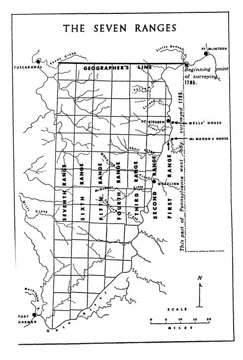
Called simply the East and West Line at
the time of survey,
it has come to be known as the
Geographer's Line, in honor
of Hutchins. In laying it out Hutchins
was required by
law to determine the latitude of the
point of beginning and
then to make the line conform to a
parallel of latitude.
In meeting the first problem Hutchins
took "a great num-
ber" of observations on the sun
and the North Star, and as
a result determined his latitude to be
40?? 38' 02" North.61
58 Entries
for July 31, September 3, 1787, Journal of John Mathews, in Hildreth,
Pioneer History, 182, 186; Memorial of Surveyors to Congress, September
22,
1787, Papers of the Continental
Congress, No. 41, Vol. 9, p. 461.
59 Martin to Hutchins, October 3, 1787.
Hutchins Papers.
60 Hutchins to Commissioners of the
Board of Treasury, July 26, 1788. Record
Group 49, Natural Resources Records
Division, National Archives. The notes and
plats for Ranges Five, Six, and Seven
may be found with the records for the
first four ranges of the Seven Ranges in
Record Group 49, Cartographic Records
Division, National Archives.
61 Hutchins to President of Congress,
November 24, 1785. Papers of the Con-
tinental Congress, No. 60, p. 194.
THE SURVEY OF THE SEVEN RANGES 135
He mislocated his position by about
25" of arc, or as measured
on the ground, by somewhat less than
one-half mile, a magni-
tude of error which suggests that he
employed a sextant, an
instrument in common use at that time.
The second prob-
lem, that of laying down a parallel of
latitude, was familiar
to Hutchins we can be sure, if only
because it is known that
he had engaged in extending westward
the Mason and Dixon
line--a parallel of latitude--in
1784.62 Whether he attempted
to repeat the relatively accurate
technique employed in that
earlier work or not--and there is
strong evidence that to save
time he did not--his results were much
less satisfactory. The
Geographer's Line failed to conform to
the proper curve of a
parallel of latitude, and it ended
fully fifteen hundred feet
south of its beginning point.
In laying out township boundaries south
of the Geograph-
er's Line the surveyors directed their
lines of sight with an
instrument called a circumferentor. It
was a simple compass,
measuring about six inches in diameter,
graduated to give
readings in degrees, fitted with sight
vanes, and mounted by
means of a ball and socket upon either
a staff ("Jacob's staff")
or a tripod.63 By the time
surveying began in earnest, it will
be recalled, congress had relieved the
surveyors of the neces-
sity of adjusting their lines to
"the true meridian." Given
this license, the surveyors used the
circumferentor's magnetic
needle to establish initial direction,
and in extending a line
they appear to have simply taken a new
compass reading at
each advance of the instrument. In
setting off a right angle
at each township corner they almost
certainly read directly
from the needle instead of turning the
angle on the instrument.
This was free-style surveying.64
62 Hutchins
to President of Congress, April 21, 1785. Papers of the Continental
Congress, No. 60, p. 181.
63 A
few places in Ohio where circumferentors may be seen are Campus Martius
Museum, Marietta; Wooster Museum,
Wooster; and Ohio Historical Society,
Columbus.
64 These remarks are based upon an
extended examination of the survey notes
for the Seven Ranges.
136 THE OHIO HISTORICAL QUARTERLY
In the measurement of distances,
approximation again was
the rule. The means employed, normal
for the period, was
a surveyor's chain made of iron wire
formed into one hundred
straight segments, each segment joined
to its neighbor by
two rings.65 The chains were
checked for length by Hutchins
at the outset of surveying, but their
results were far from
consistent. While it is well known that
such chains were
subject to alteration in length through
use, a more important
source of error was the roughness of
the terrain, or, more
exactly, the lack of care taken by the
surveyors in safeguard-
ing against errors arising therefrom.
What with an almost
casual determination of distance as
well as direction, the
surveyed lines generally failed to join
satisfactorily at the
corners of the townships, as would be
expected. The sur-
veyors failed to meet this problem of
poor closure, in turn,
in any agreed-upon way; they did not
regularly complete their
townships in one specified corner; and
they did not retrace
their lines in search of error when a
faulty closure occurred.66
Inaccuracies in the survey of the Seven
Ranges should not
be thought of as wholly or even mainly
the consequence of
an inadequate technology. When the
federal rectangular
survey system was revived and extended,
only about a decade
later, distinctly improved results were
obtained; and among
the sharpest critics of the original
surveyors were men who
followed after them, with no better
instruments, to further
subdivide the townships of the Seven
Ranges.67 The work
of the original surveyors suffered
principally from a lack of
regular operating procedures and
clearly stated standards of
accuracy.
* * *
65 Chains of the kind described may be found in county surveyors' offices;
at
the Ross County Historical Society,
Chillicothe; and at the Ohio Historical
Society, Columbus.
66 These statements are based upon the surveyors' notes, letters, diaries,
a map
of the survey lines compiled by the
author, and United States Geological Survey
topographic maps.
67 See Rufus Putnam to Zaccheus Biggs, April 22, 1801, in Carter, Territorial
Papers, Vol. III, The Territory Northwest of the River Ohio,
1787-1803, Conti-
nued (Washington, 1934), 130-132.
THE SURVEY OF THE SEVEN RANGES 137
As is well known, the direct
contribution of the survey of
the Seven Ranges to the settlement of
the Northwest Territory
was very slight indeed. The first and
only sale of land in
the Seven Ranges under the land
ordinance of 1785 was held
in New York City, September 21-October
9, 1787, after an
impatient congress had voted to wait
for the completion of no
more than four ranges of townships, and
to offer the parts
of those townships not reserved from
sale at a central place
of auction rather than in the several
states, as originally
planned.68 At the sale, land
immediately bordering the Ohio
River found a fair market, and two
townships near the
Ohio were sold as whole units, but
buyers could not be tempted
very far inland nor induced to take up
all of the land along
the river so long as a minimum price of
one dollar per acre,
established by law, prevailed. With
less than one-third of the
land spoken for, the auction was
closed.69 About half of this
purchased land was soon forfeited for
lack of completed pay-
ment, and on the remainder settlement
was almost negligible.
The single noteworthy extension of the
American frontier
immediately resulting from this sale
occurred on the Ohio a
few miles upstream from a point
opposite Wheeling late in
1787, when Absalom Martin, official
federal surveyor from
New Jersey, founded there the
settlement known today as
Martins Ferry.70
To appreciate the indirect and highly
important influence
of the survey of the Seven Ranges upon
the advance of set-
tlement in the Northwest Territory, we
must turn our atten-
tion to the Ohio Company of Associates,
that celebrated or-
ganization whose representatives
contracted to buy a large
tract adjacent to the Seven Ranges a
few days after the
public auction in New York was closed.
Benefits conferred
on this group began in 1785, when
General Benjamin Tupper,
68 In
changing its policy, congress followed recommendations in a report of the
board of treasury, for which see Carter,
Territorial Papers, II, 24-25.
69 Accounts for this auction appear as "Schedule of Sales of Lands in
the Western
Territory," in Papers of the
Continental Congress, No. 59, Vol. 3, pp. 135-140.
70 For record of purchase of over three hundred acres of land in Martin's
name,
see ibid., p. 135.
138
THE OHIO HISTORICAL QUARTERLY
by adopting the role of surveyor for
Massachusetts, found
an opportunity for learning at first
hand about the route to
Pittsburgh and the country downstream
from that settle-
ment for a distance of about forty
miles. The Ohio Company
had not yet been formed, but its
prospective organizers, among
them Tupper, were known to be
contemplating the founding
of a colony. In the summer of 1786, by
which time provi-
sional articles of the Ohio Company had
been drawn up at a
meeting in Massachusetts, federal
surveying began to look
as though it were specifically meant to
serve the exploratory
interests of this association. No less
than five Ohio Company
men, including Tupper, appeared among
the surveyors in
1786, and one of them, Winthrop
Sargent, detached himself
from the rest to reconnoiter the
district on the lower Muskin-
gum River which the company was soon to
apply for in con-
gress.71 The fact that this tract of land
lay immediately
west of the Seven Ranges should not
lead one to suppose that
Sargent thought of it as an area beyond
the scope of federal
surveying. Rather, he viewed it at this
time as land included
within the breadth of the thirteen
ranges of townships
scheduled for survey in 1786.72 By
1787, however, the out-
look had changed. With only seven
ranges of townships
begun by the national surveyors, the
Ohio Company, appar-
ently impelled by a new determination
to obtain land in a
single block, threw its influence
behind a move in congress
to halt any further extension of
surveying to the west.
Deciding to apply to congress for a
direct grant of land,
directors of the company declared,
"We . . . wish, if possible,
to have our eastern bounds on the
seventh range of town-
71 Sargent recorded this side trip,
which took him down the Ohio and up the
Muskingum, in his Diary, entries for
July 23 to August 1. The Ohio Company men
in addition to Tupper and Sargent, were
Ebenezer Sproat, of previous mention,
and two young men who came west as
chainmen: Tupper's son Benjamin and
Putnam's nephew John Mathews.
72 Sargent
to Samuel Parsons, August 1, 1786. Samuel Parsons Papers, West-
ern Reserve Historical Society.
THE SURVEY OF THE SEVEN RANGES 139
ships."73 The company
succeeded in obtaining a grant with
this boundary and went on to conduct
township surveying
privately, but otherwise in general
conformity to the require-
ments of the land ordinance of 1785.
In a rather elaborate advertisement of
its new purchase,
the Ohio Company drew freely upon the
opinions and obser-
vations of its representatives who had
engaged in the survey
of the Seven Ranges, a procedure
justified by the fact that
the Ohio Company lands comprised a
continuation of the
Allegheny Plateau country wherein the
Seven Ranges lay.
By way of further reliance upon the
federal surveys, this
same advertisement exploited the
reputation of Thomas
Hutchins by including his testimonial
that descriptions ap-
pearing therein were "judicious,
just and true," and consistent
with "observations made by
me."74
Nor did the services rendered to the
Ohio Company by the
federal surveys end here. In the course
of the survey of the
Seven Ranges, the army's influence had
been brought down
the Ohio to the mouth of the Muskingum
River, where the
Ohio Company's first settlement would
soon be made; the
Indians had been introduced to the kind
of surveying which the
Ohio Company would be continuing; and
the squatter popula-
tion of the Ohio country had been
confronted by the deter-
mination of congress to deny the right
of preempting land by
"tomahawk claim," a legal
position which the Ohio Company
was resolved to perpetuate.75
73 Rufus Putnam and Manasseh Cutler to
Winthrop Sargent, May 1787, as
quoted in Hulbert, Records of the
Ohio Company, liii.
74 The advertisement, titled "An
Explanation of the Map Which Delineates That
Part of the Federal Land Comprehended
between Pennsylvania West Line, the
Rivers Ohio and Scioto and Lake Erie . .
.," may be found in Philip Lee Phillips,
The First Map and Description of
Ohio, 1787, by Manasseh Cutler: A Biblio-
graphical Account (Washington, 1918), 25-41.
75 In the very month that the Ohio
Company made its first settlement, congress
renewed its denial of the right of
roving pioneers to take up land at will on the
public domain. Resolution of April 24,
1787, in Journals of the Continental Con-
press, XXXII, 231.
140
THE OHIO HISTORICAL QUARTERLY
If the founding of Marietta at the
mouth of the Muskin-
gum River by the Ohio Company, in April
1788, is to be
accepted as the beginning of organized
American settlement
in the Northwest Territory, then the
Seven Ranges should
be recognized with appropriate honor as
the bridgehead
which made the success of this pioneer venture
possible.