Ohio History Journal
A NEWLY DISCOVERED EXTENSION OF THE
NEWARK WORKS
By DACHE M. REEVES1
The study of aerial photographs of the famous Newark group
of prehistoric earthworks resulted in the discovery of a hitherto
unknown extension to these works. An interesting feature of this
discovery is the fact that an important section of the works was
found on the Newark flying field. This area had been prepared
for flying purposes after having been under cultivation for a long
period, and the former embankments were obliterated entirely.
It would have been difficult, if not impossible, to have located
these earthworks on the ground, but on the photograph they stand
out clearly. This is a striking illustration of the value of aerial
photography in archaeology.
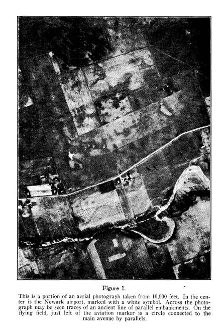
A portion of one of the aerial photographs is reproduced
herewith as Figure 1. This photograph was taken from 10,000
feet in January, 1934, the winter season being selected in order
to have the ground as bare as possible. Figure 4 is a tracing of
the salient features of the photograph, showing the L-shaped fly-
ing field and the parallel embankments forming a long avenue.
The small white circle with three arms on the flying field is the
usual symbol employed to mark airdromes.
It will be observed that the avenue, after passing the airport,
makes a slight bend and continues to the edge of the terrace on the
north bank of the stream. Tracing backward, the avenue can be
followed almost to the octagon, the northern end being destroyed
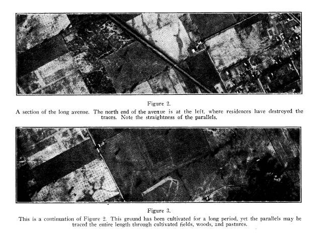
by a residential suburb of Newark. The avenue is remarkably
straight, as shown in Figures 2 and 3.
1 Captain Dache M. Reeves, of the U. S. Army Air Corps, is one of America's
outstanding experts in aerial photography. For the past two years he has been co-
operating with the Society in an aerial survey of the ancient mounds and fortifica-
tions of Ohio with most gratifying results. The survey, rearing completion, will be
a definite asset to Ohio prehistory, and will place the State well in the forefront in this
most recent method of recording and interpreting major archaeological evidences.--
H. C. Shetrone.
(189)
|
190 OHIO ARCHAEOLOGICAL AND HISTORICAL QUARTERLY |
|
|

|
The length of the avenue is 4300 yards, which agrees closely with Ephraim George Squier and Edwin Hamilton Davis who stated the parallels were two and one-half miles long.2 However, 2 Ephraim George Squier and Edwin Hamilton Davis, Ancient Monuments of the Mississippi Valley (Cincinnati, 1848). |
|
EXTENSION TO THE NEWARK WORKS 191 |
|
|
|
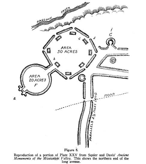
Col. Charles Whittlesey, who made the survey for
Squier and Davis, only followed the avenue a short distance. A
portion of his plan published as Plate XXV in Ancient Monuments is
repro- |
192 OHIO ARCHAEOLOGICAL AND
HISTORICAL QUARTERLY
duced herewith as Figure 5. By failing
to follow out the length
of the avenue, Whittlesey missed
entirely the branch avenue and
circle on the Newark airport. It is
strange that this was over-
looked, as at the time the original
survey was made, nearly a hun-
dred years ago, the earthworks were
still undisturbed by culti-
vation.
A detailed analysis of these newly
discovered features will be
made in connection with a larger study
of the so-called "geome-
trical earthworks." However, it may
be of interest to discuss
briefly the significance of this
discovery. This Newark avenue
is the longest straight line of parallel
embankments constructed
by prehistoric builders and demonstrates
a considerable knowledge
of elementary surveying. Like the
majority of similar avenues,
it ends at a stream. It is possible when
other prehistoric sites
are studied further, that all such
avenues will be found to lead to
a running stream. This would indicate
that the purpose of build-
ing the parallel embankments was to
provide a passage-way for
processions of a ceremonial or sacred
character.
It is puzzling to note that this Newark
avenue extends over
two miles from the octagon to a small
stream, whereas the octagon
is located within a short distance of
Raccoon Creek, and if the
avenue had extended north instead of
south, it need only have
been about a hundred yards long.
Furthermore, Raccoon Creek
is a larger stream than Ramp Creek on
the south.
A short distance from the southern
terminus of the avenue,
a side avenue leads off to a small
circle. This side branch is not
a true parallel, as the two walls
converge slightly as they approach
the main avenue. The reason for this was
found in a small knoll
at the inner angle of the airport. The
north wall of the side
avenue was shifted slightly south in
order to avoid climbing the
knoll. Yet the main avenue pursues a
straight course regardless
of the varying slope of the ground.
At the center of the junction between
the main avenue and
the side branch, traces of a circular
earthwork can be detected on
the photograph. This may have been a
circular mound with sur-
rounding ditch, but this is only a
guess, as the destruction is so
EXTENSION TO THE NEWARK WORKS 193
complete the exact character of this
object cannot be determined.
Excavation at this point might clear up
the difficulty. The pur-
pose of the small circle and side avenue
is unknown. Further
study of earthworks may yield some
definite information.
The labor required to construct
earthworks of the size com-
prising the Newark group was immense
when the lack of tools is
considered. The builders possessed only
crude non-metal digging
tools such as shell and wood, and their
only means of transport-
ing the material was in basket-loads on
their backs. Under these
circumstances, it required a powerful
motive to undertake and
complete such elaborate works. Whether
executed by forced labor
(that is, slaves, war captives, or
subjects of an American Cheops)
or by voluntary effort, the inspiration
for such structures of a
non-utilitarian character was,
undoubtedly, in the religious beliefs
of the builders.
To learn more about these prehistoric
people we must read
their records; not their written
records, as they left none, but the
evidences of their labor. A great deal
has been learned from a
study of pottery, stone artifacts and
other objects recovered from
graves and found in the fields, and the
study of their most dis-
tinguishing characteristic--the great
earthworks--will add much
to the knowledge of prehistoric America.
Unfortunately, for
over a hundred years, the farmer has
done his best to destroy
every earthwork within reach of his
plow, ably seconded by the
railway and highway constructors. It is
only in recent years that
efforts to preserve America's
antiquities have met with any suc-
cess, and meanwhile many monuments are
totally destroyed.
Some consolation is found in the
valuable assistance aerial
photography has contributed to
archaeological study. As in the
present case, photographs have enabled
surveys to be made of
earthworks previously obliterated. As
the method of air survey
comes into extended use, more and more
accurate data will be
accumulated as a basis for the study of
our prehistoric predeces-
sors on this continent.