Ohio History Journal
THE EVOLUTION OF OHIO COUNTIES.
By J. F. LANING.
It is probable that the people who read
this article will all
know that the State of Ohio was not
always divided into the
number of counties there now are, and
that to evolve the present
map, a long period of time and many
mutations of county outlines
were necessary. But few people, however,
know the extent of
the evolution that has been going on, in
bringing Ohio counties
within their present environments. From
the erection of the first
county, in 1788, the number has been
made to grow each year,
by cutting down the size of those
previously formed, until, by the
limits of the constitution of 1851,
requiring each of them to con-
tain four hundred square miles, it is
scarcely possible to now find
a locality where the existing counties
could let territory enough
go to form a new one.
The importance of the county as a
political unit varies in
different parts of the United States. In
New England it takes
a secondary rank, that of the townships
being first. In the
Southern States the position is
reversed, the county, or parish
as it is called, being the leading
agency for local government.
In the State of Ohio, as also in the
other Western States, the
county and the township each has its
special features in the frame
of government, and they do not vary much
in their importance.
The structure of government here
existing is of such a character,
that it may be appropriately called a
mixed or dual system, as
it properly has a double unit in the
township and county, for each
of these divisions has its primary
functions to perform, and neither
outranks the other to any great extent.
Each is a unit in making
up the united whole represented
collectively in the State govern-
ment.
As it is possible that there may be some
who, in this day of
our fully formed State and perfected
plan of government, may
not be aware that the soil of Ohio was
once a part of a territory
of the United States, as Alaska, Utah
and Oklahoma are now
(326)
The Evolution of Ohio Counties. 327
territories, it is proper to refer to
the fact, that at one time it was
in an unorganized civil condition, and
that, later, its first chief
magistrate was a territorial governor,
appointed by the author-
ities at Washington, as the governors of
Western territories are
now selected. The country embracing what
are now the States
of Ohio, Indiana, Illinois, Michigan and
Wisconsin, first came
to be known as a part of our nation,
under the name of the North-
west Territory, and provision for its
government was made by
Congress, through a law known as the
Ordinance of 1787. Ar-
thur St. Clair was appointed as the
first governor of the Territory,
and through his action the first
counties were established.
Historically speaking, county government
here came into
existence before that of townships.
Counties were organized
for the purpose of establishing court
districts, and county areas
were defined about as soon as the work
of governing the Territory
began. The first law for this domain was
for the purpose of reg-
ulating the militia, and the second for
organizing the courts.
Those providing for the officers and
affairs of townships came
later.
In their original creation and
formation, county and town-
ship divisions were independent of each
other, the townships not
being required to first exist as a basic
factor in forming the coun-
ties, nor the county to be, as it now
appears, the aggregation of
a number of pre-existing townships.
County lines were not, at
first, concurrent with township lines,
and it was often necessary
for the county area to be made up
without regard to the confines
of townships, because, in some cases,
counties were created before
the township surveys had been commenced.
The Ordinance of
1787 was preceded by what was known as
the Ordinance of 1785,
sometimes called the Land Ordinance.
This made provision
for the survey of the western lands, and
their division into town-
ships. This however, was for the purpose
of getting them into
farms, and making them ready for market
and occupancy, and
not for government. The Ordinance of
1785 applied only to
government lands, and made provision
that they should be sur-
veyed into townships six miles square,
but no rule was ever en-
acted for laying out the tracts disposed
of by the government to
land companies. Their proprietors cut
them up into farms to
328 Ohio Arch. and His. Society Publications.
suit their own liking, and into sections
of various size and form.
The United States thus lost control over
the manner of running
township lines, and what is now regarded
as our primary civil
division was not laid out with a view of
its becoming a factor in
a higher county area, or a unit in a
county organism.
St. Clair was authorized, by the
Ordinance of 1787, to lay out
the territory into counties and
townships, but there is no record
of his ever having interfered with the
freedom of land owners to
form townships. Counties, however, were
never allowed to
emerge in the irregular manner that
townships did. Their larger
functions, and their nearer relation to
the central government
of the State, made it necessary for the
ruling power to assume
control of their erection, and
alteration, when required, and from
the earliest period of our civil
existence, counties have been
brought into existence by the will of
the government, executed
through its executive or legislative
department. In the progress
of our State from an ungoverned
wilderness to a fully organized
and practically self-governed
commonwealth, the edict of the rul-
ing power has always directed the course
and length of county
boundaries.
With these remarks concerning the nature
and historical
relation of townships and counties, we
now proceed to give some-
thing of the details of the evolution of
the early Ohio counties.
The Ordinance of 1787 prescribing the
manner that the
Northwest Territory should be governed,
provided that "for the
execution of process, civil and
criminal, the governor shall make
proper divisions thereof; and he shall
proceed from time to time,
as circumstances may require, to lay out
the parts of the district
in which the Indian titles have been
extinguished, into counties
and townships, subject however, to such
alterations as may there-
after be made by the legislature."
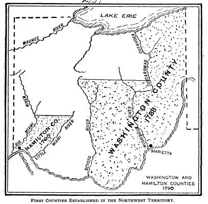
WASHINGTON COUNTY.
St. Clair was appointed governor of the
Territory, October 5,
1787, and arrived at Marietta, July 9,
1788. His first act toward
carrying out the provisions of the
Ordinance, as to the establish-
ment of local government, was to erect
the county of Wash-
|
The Evolution of Ohio Counties. 329
ington. He issued an order defining its boundaries, July 27, 1788. They were as follows: "Beginning on the bank of the Ohio river, where the western boundary line of Pennsylvania crosses it, and running with that line to Lake Erie; thence along the southern shore of said lake, |
|
|
|
to the mouth of Cuyahoga river; thence up said river to the portage, between it and the Tuscarawas branch of the Muskin- gum; thence down that branch to the forks, at the crossing place above Fort Lawrence (Laurens); thence with a line to be drawn westerly to the portage, on that branch of the Big Miami on which the fort stood that was taken by the French in 1752 (Lora- mie's Store), until it meets the road from the lower Shawnee |
330 Ohio Arch. and His. Society Publications.
town to Sandusky; thence south to the
Scioto river; thence with
that river to the mouth, and thence up
the Ohio river to the place
of beginning."
It will be seen that this county
comprised a large part of the
eastern and northern portions of what is
now the State of Ohio.
It received its name in honor of
President Washington. St.
Clair not only exercised the right to
lay off the counties, but to
designate the place that the county
business should be transacted.
He named Marietta as the chief town of
Washington county.
HAMILTON COUNTY.
The next county formed by St. Clair was
Hamilton. His
edict brought it into existence January
2, 1790. Its boundaries
were as follows:
"Beginning on the bank of the Ohio
river, at the confluence
of the Little Miami, and down the said
Ohio river to the mouth
of the Big Miami, and up said Miami to
the standing stone forks
or branch of said river, and thence with
a line to be drawn due
east, to the Little Miami, and down said
Little Miami to the
place of beginning."
It will be seen that this county at
first contained only a small
strip between the two Miami rivers. It
was subsequently en-
larged, as will be shown farther on. It
received its name from
Gen. Alexander Hamilton. Its place of
holding court was fixed
by St. Clair, at Cincinnati.
ST. CLAIR COUNTY.
The next county to be set off, was that
of St. Clair, in that
part of the territory now included in
Illinois. It was proclaimed
April 27, 1797, and was bounded as
follows:
"Beginning at the mouth of the
little Michilmacinack river,
running thence southerly in a direct
line to the mouth of the
little river above Fort Massac, on the
Ohio river; thence with
the Ohio to its junction with the
Mississippi; thence up the Mis-
sissippi to the mouth of the Illinois
river, and so up the Illinois
river to the place of beginning."
The Evolution of Ohio Counties. 331
St. Clair divided the county bearing his
name into three
judicial districts, viz: Cahokia,
Prairie du Rocher, and Kaskaskia,
in which terms of court were to be held
the same as if they were
separate counties.
KNOX COUNTY.
On the 20th of June, 1790, St. Clair set
off the county of
Knox, most of which is now in the state
of Indiana, with bound-
aries as follows:
"Beginning at the standing stone
forks of the Great Miami
river and down the said river to the
confluence with the Ohio
river, thence with the Ohio to the small
stream or rivulet above
Fort Massac; thence with the eastern
boundary line of St. Clair
county to the mouth of Little
Michilmacinack; thence up the Il-
linois river to the forks or confluence
of the Theokiki and Chi-
cago; thence by a line to be drawn due
north to the boundary
line of the territory of the United
States, and so far easterly upon
said boundary line as that a due south
line may be drawn to the
place of beginning."
HAMILTON COUNTY ENLARGED.
February 11, 1792, St. Clair issued a
proclamation, setting
forth the new county provision of the
Ordinance of 1787, by
which it was provided that new counties
should be laid out as
fast as the Indian titles were
extinguished. There was a portion
of the Territory lying between the
Scioto and the Little Miami,
which had not yet been included in a
county. This, he said,
on account of the scattered nature of
the settlements, did not
justify the erection of a new county,
and he added it to the county
of Hamilton. The boundaries of this
county were then as fol-
lows:
"Beginning at the confluence of the
Scioto with the Ohio
river, and up the Scioto with the
courses thereof to the upper
part of the old lower Shawnee town upon
said river; thence by
and with a line to be drawn due north to
the territorial boundary
line, and westerly along said boundary
line to the eastern bound-
ary of the county of Knox, and down
along the said eastern
|
332 Ohio Arch. and His. Society Publications. |
|
|
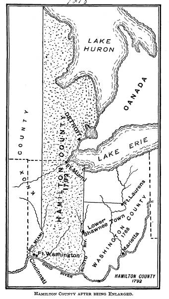
The Evolution of Ohio Counties. 333
boundary of Knox county by a due south
line to the standing
stone forks of the Great Miami river,
and with the said Miami
to its confluence of the Ohio river;
thence up the Ohio river
to its place of beginning."
RANDOLPH COUNTY.
On the 15th day of October, 1795, St.
Clair issued a procla-
mation reciting that the separation of
the county of St. Clair into
districts had not given that ease and
facility to the administration
of justice which was expected, and it became
necessary that it
be divided, and a new county erected.
The territory south of a
line running due east from what was
known as the Cove Spring,
to the Knox county line, was made the
county of Randolph.
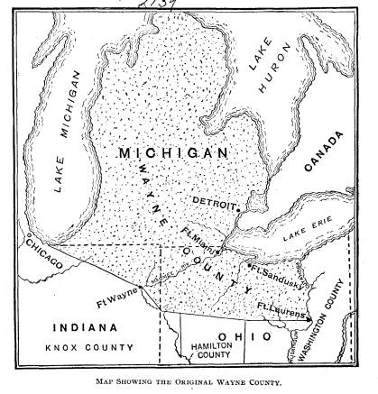
WAYNE COUNTY.
There was a wide stretch of country on
the north part of
the Territory that was yet outside of
any of the organized counties.
On the 15th day of August, 1796, Wayne
county was organized,
with boundaries as follows:
"Beginning at the mouth of Cuyahoga
river, upon Lake Erie,
and with the said river to the portage,
between it and the Tus-
carawas branch of the Muskingum; thence
down the said branch
to the forks, at the carrying place
above Fort Lawrence (Laurens);
thence by a west line, to the eastern
boundary of Hamilton county,
(which is a due north line from the
lower Shawnee town upon
the Scioto river); thence by a line
west-northerly to the southern
part of the portage, between the Miamis
of the Ohio and the
St. Marys river; thence by a line also
west-northerly, to the
southwestern part of the portage,
between the Wabash and the
Miamis of Lake Erie, where Fort Wayne
now stands; thence
by a line west-northerly, to the most
southern part of Lake Mich-
igan; thence along the western shores of
the same, to the north-
west part thereof, (including the lands
upon the streams empty-
ing into said lake); thence by a due
north line to the territorial
boundary in Lake Superior, and through
the said boundary
through lakes Huron, Sinclair, and Erie,
to the mouth of the
Cuyahoga river, the place of
beginning."
|
334 Ohio Arch. and His. Society Publications.
This, as will be seen, cut off the northern portion of the coun- ties of Knox and Hamilton. The Northwest Territory was now divided into the six counties of Washington, Hamilton, Knox, St. Clair, Randolph and Wayne. |
|
|
|
ADAMS COUNTY. In order to establish more counties, as the existing ones embraced all of the Territory, it was now necessary to make a di- vision of some of those that had already been erected. The first separation to be made was for the purpose of creating Adams |
The Evolution of Ohio Counties. 335
county. Hamilton county was large, and
could well be divided.
So, July 10, 1797, a county, called
Adams, was taken off its east
side, with boundaries as follows:
"Beginning at the Ohio river at the
upper boundary of that
tract of 24,000 acres of land, granted
unto the French inhabitants
of Gallipolis * * * thence down the said
Ohio river, to the
mouth of Elk river, (generally known as
Eagle creek) and up
with the principal water of the said Elk
river or Eagle creek,
to its source or head; thence by a due
north line, to the southern
boundary of Wayne county, and easterly
along said boundary,
so far that a due south line shall meet
the interior point of the
upper boundary of the aforesaid tract of
land of 24,000 acres,
and with the said boundary to the place
of begining."
This county was named in honor of
President Adams. Con-
cerning its county seat, Howe, in his
Historical Collections, says:
"The first court in this county was
held in Manchester.
Winthrop Sargent, the secretary of the
teritory, acting in the
absence of the governor, appointed
commissioners, who located
the county seat at an out of the way
place, a few miles above the
mouth of Brush Creek, which they called
Adamsville. The lo-
cality was soon named, in derision, Scant.
At the next session
of the court its members became divided,
and part sat at Adams-
ville, and part Manchester. The
governor, on his return to the
territory, finding the people in great
confusion, and much bick-
ering between them, removed the seat of
justice to the mouth of
Brush creek, where the first court was
held in 1798. Here a town
was laid out, by Noble Grimes, under the
name of Washington.
A large court-house was built, with a
jail in the lower story, and
the governor appointed two more of the
Scant party judges,
which gave them a majority. In 1800,
Charles William Byrd,
secretary of the territory, in the
absence of the governor, ap-
pointed two more of the Manchester party
judges, which balanced
the parties, and the contest was
maintained until West Union
became the county seat."
336 Ohio Arch. and His.
Society Publications.
JEFFERSON COUNTY.
The next county to be divided was that
of Washington. In
1786 the Seven Ranges had been surveyed
and July 29, 1797, a
portion of the northern part of the
pioneer county was eliminated,
and made into the county of Jefferson.
The boundaries of the
new county were as follows:
"Beginning upon the bank of the
Ohio river, where the west-
ern boundary of Pennsylvania crosses it,
and down the said river
to the southern boundary of the fourth
township in the third
range, (of those townships that were
surveyed in conformity to
the ordinance of Congress of the 20th of
May, 1785), and with
the said southern boundary west, to the
S. W. corner of the sixth
township in the fifth range; thence
north, along the western
boundary of said fifth range to the
termination thereof; thence
due west to the Muskingum river, and up
the same to and with
the portage, between it and the Cuyahoga
river; thence down
Cuyahoga, to Lake Erie; thence easterly
along the shores of
the lake, to the western boundary of
Pennsylvania, and south
with the same to the place of
beginning."
The county received its name from
President Jefferson. Some
idea of its original size may be known
from the fact that, when
established, it included within its
boundaries what are now the
cities of Cleveland, Akron, Canton,
Warren, Steubenville, and
Youngstown. Its county seat has always
been at Steubenville.
HAMILTON COUNTY EXTENDED.
The next act in the work of dividing the
Territory into coun-
ties, was changing the boundaries of the
counties of Hamilton,
Wayne, and Knox. In 1795, General Wayne
had made a treaty
with the Indians, at Greenville, by
which the line of the lands of
the United States had been extended from
Loramie's, westward
to Fort Recovery, and thence southward
to the mouth of the
Kentucky river. The boundary of Hamilton
county was extended
westward, June 22, 1798, to make it
correspond with this change
in the boundary of the government
territory. The line between
Hamilton and Knox counties then became:
The Evolution of Ohio Counties. 337
"The western boundary of the county
of Hamilton shall be-
gin at the spot, on the bank of the Ohio
river, where the general
boundary line of the United States and
the Indian tribes, estab-
lished at Greenville the third day of
August, 1795, intersects the
bank of that river, and run with that
general boundary line to
Fort Recovery, and from thence by a line
to be drawn due north
from Fort Recovery, until it intersects
the southern boundary
line of the county of Wayne, and from
thence to the southern
boundary of the county of Wayne, shall
also be the eastern bound-
ary of the county of Knox."
Hamilton county in this way got a part
of Knox county,
and a part of what is now Indiana.
ROSS COUNTY.
Ross next came into the family of Ohio
counties. Nathaniel
Massie, a surveyor in the employ of
Virginia, had laid out the
town of Manchester, in 1790, and induced
people to emigrate
to it. Massie had become a large land
owner, and circulated
glowing descriptions of the country
along the Scioto, with the
hope of inducing settlements. Robert J.
Finley, and a Presby-
terian congregation from Kentucky, were
attracted, and a set-
tlement was made at the mouth of Paint
creek. Chillicothe was
laid out in August, 1796, by Col.
Massie. The opening of Zane's
Trace, soon afterwards, diverted much of
the westward travel,
which before this time had been in boats
down the Ohio, and
brought it overland through this region.
Other settlements
sprung up, and with the increase in
settlers, demands were put
forward for a division of Adams county.
St. Clair recognized
the need of the new county, and, August
20, 1798, issued a pro-
clamation for it, in which the
boundaries were fixed as follows:
"Beginning at the forty-second mile
tree, on the line of the
original grant of land by the United
States to the Ohio com-
pany * * * and running from thence west
until it shall in-
tersect a line to be drawn due north
from the mouth of Elk river
(commonly called Eagle creek), and from
the point of intersec-
tion running north, to the south
boundary of the county of Wayne,
and from thence easterly with the said
boundary of Wayne, until
|
338 Ohio Arch. and His. Society Publications
a north line to be drawn from the place of beginning, shall in- tersect the same; and if it should be found that a north line to be |
|
|
|
drawn from the place of beginning, will not intersect the said southern boundary of Wayne, then an east line is to be drawn |
The Evolution of Ohio Counties. 339
from the eastern termination of the said
boundary, until it shall
intersect the aforesaid north line to be
drawn from the place of
beginning."
Among the early settlers in this region
were a number from
Pennsylvania, among whom were, Dr.
Edward Tiffin who after-
wards became the first governor of the
state, and Mr. Thomas
Worthington, who became governor of the
state and United
States Senator. The county received its
name from Hon. James
Ross, of Allegheny county, Pa., who was
at that time the unsuc-
cessful candidate of the Federal party
for the office of governor
of that state. St. Clair was an ardent
Federalist, and had been
a member of Congress from Pennsylvania.
Chillicothe was made
the seat of justice. In 1800 it became
the capital of the North-
west Territory. The sessions of the
territorial legislature were
held there, in 1801, and the convention
which framed the first
constitution of Ohio met there, in 1802.
It was the state capital
from that time until 1816, except during
the years 1810-1812.
August 20, 1798, a strip was taken off
the east side of Ham-
ilton county, and added to Adams. The
west line of Adams was
made to commence on the Ohio, at the
mouth of Eagle creek,
and run due north until it intersected
the southern boundary of
Ross, instead of following up the river
to its head, as in the orig-
inal boundaries.
CONTROVERSY OVER NEW COUNTIES.
This list of nine counties comprised
what had been erected
when, in pursuance of the proclamation
from St. Clair, a terri-
torial legislature was elected, in
December, 1788. This procla-
mation was in obedience to the
requirements of the Ordinance
of 1787, as follows:
"So soon as there shall be five
thousand free male inhabit-
ants, of full age, in the district, upon
giving proof thereof to the
governor, they shall receive authority,
with time and place, to
elect representatives from their
counties or townships, to repre-
sent them in the General Assembly;
provided that for every five
hundred free male inhabitants there
shall be one representative,
and so on progressively with the number
of free male inhabitants,
340 Ohio Arch. and His. Society Publications.
shall the right of representation
increase, until the number of
representatives shall amount to
twenty-five, after which the num-
ber and proportion of representatives
shall be regulated by the
Legislature; provided, that no person be
eligible or qualified to
act as a representative, unless he shall
have been a citizen of one
of the United States three years, and be
a resident in the district,
or unless he shall have resided in the
district three years, and in
either case shall likewise hold in his
own right, in fee simple,
two hundred acres of land within the
same; provided also, that
a freehold in fifty acres of land in the
district, having been a cit-
izen in one of the states, and being
resident in the district, or the
like freehold and two years' residence
in the district, shall be
necessary to qualify the man as an
elector of a representative."
Some idea of the population of the
territory, at that time, may
be formed from the representation the
different counties obtained
in the Territorial Legislature.
Washington had two, Hamilton
seven, Ross four, Adams two, Wayne
three, and St. Clair, Ran-
dolph, Knox and Jefferson one each. New
Connecticut was a
part of the territory, governed under
the laws of Connecticut,
and would have been entitled to a
representation, but had none,
because, as St. Clair said, he did not
know of population enough
in the district to entitle it to a
member.
The legislature met at the appointed
place, February 4, 1799.
Before this time the people of several
localities in the territory
had been clamorous for the erection of
new counties, but their
desires had been refused by St. Clair.
The territorial legislature
having met, the matter now came before
that body, and was a
disturbing element between the executive
and the General As-
sembly. Several acts were passed
creating new counties, or
changing the boundaries of those already
existing. The legis-
lature insisted that, after the governor
had laid out the country
into counties and townships, as he had
already done, it was com-
petent for them to pass laws, altering,
dividing, and multiplying
them at their pleasure, to be submitted
to him for his approba-
tion: that when the territory had been
divided into counties by
the governor, his exclusive power was
exhausted, and any altera-
tions thereafter required, were to be
made by the legislature, with
his assent. But St. Clair would not
assent to any laws changing
The Evolution of Ohio Counties. 341
the boundaries of counties, or erecting
new ones. Six acts
of the kind, passed at this session,
were vetoed by him. The
governor made a speech to the
legislature, on the day of its ad-
journment, in which he said:
"I am truly sensible, gentlemen, of
the inconveniences that
follow from a great extension being
given to counties; they can-
not, however, be constructed while the
settlements are otherwise,
and the inconveniences are not lessened,
but rather increased
by being made very small, with respect
to the number of inhabit-
ants.
"The expenses which necessarily
attend the establishment of
counties fall light when divided amongst
a number, but become
a heavy burden when they must be borne
by a few, and the in-
convenience of attending the courts as
jurors and witnesses, which
are sometimes complained of, are
increased nearly in the same
ratio as the counties are multiplied
within the same bounds.
"There is yet another reason,
gentlemen, why those acts were
not assented to. It appears to me that
the erecting of new coun-
ties is the proper business of the
executive. It is, indeed, pro-
vided that the boundaries of counties
may be altered by the legis-
lature; but that is quite a different
thing from originally estab-
lishing them. They must exist before
they can be altered, and
the provision is expressed that the
governor shall proceed from
time to time, as it may become necessary
to lay them out. While
I shall ever most studiously avoid
encroaching on any of the
rights of the legislature, you will
naturally expect, gentlemen,
that I should guard, with equal care,
those of the executive."
Another reason given by St. Clair for
his dissent to the bills
for erecting new counties, was, as he
said, that in some of them
the present number of inhabitants could
not support a county,
as it was not probable that the names of
every man living within
the proposed boundary exceeded a
hundred. St. Clair's biog-
rapher, in the St. Clair Papers,
advances another reason for his
conservatism. He says: "The greed
which characterized the
transactions in land, actuated those who
were speculators, to seek
to control the establishment of county
towns. They hoped to
increase the value of their lands, as
the public improvements in
342
Ohio Arch. and His. Society Publications.
the way of buildings and roads, and
superior advantages incidental
to a county seat, would attract the
better class of settlers to such
neighborhood." An illustration of
this is afforded in the case of
the strife in the county of Adams, to
which reference has been
made.
It is quite likely that the true secret
of St. Clair's unwilling-
ness to erect new counties, was, that if
a large number of them
were represented in the legislature, the
chance of his exercising
much political influence over the body
would be diminished.
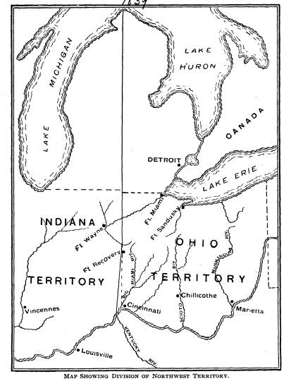
DIVISION OF THE NORTHWEST TERRITORY.
The next movement in the evolution of
the territorial divis-
ions of the Northwest Territory, was the
act of Congress dated
May 7, 1800. This provided for the
separation of the western
part of the territory, and calling it
the Indiana Territory. The
division was to be at a line beginning
on the Ohio opposite the
mouth of the Kentucky river; thence
northerly to Fort Recov-
ery; and thence north to an intersection
of the territorial line
between the United States and Canada.
This line divided the
lower Michigan peninsula into two nearly
equal parts, but it did
not remain in force for any considerable
time. The eastern di-
vision, thus created, was to remain
under the existing govern-
ment, and the western division to be
organized under a similar
one.
It was also provided in the act, that
when the eastern part
should be formed into a state, the
western boundary line should
be changed, and begin at the mouth of
the Great Miami river,
and run thence due north to the Canada
line. A division of the
territory into states had been
contemplated in the Ordinance of
1787, and this provision for changing
the western boundary,
made the act coincide with the terms of
the Ordinance upon the
subject. Its requirements were:
"There shall be formed in the said
territory, not less than
three, nor more than five states; and
the boundaries of the states,
* * * shall become fixed and established
as follows, to-wit:
The western state in the said territory
shall be bounded by the
Mississippi, the Ohio and Wabash rivers;
* *
* the middle
states shall be bounded by the * * *
line from the Wabash
|
The Evolution of Ohio Counties. 343
and Post Vincents due north to the territorial line between the United States and Canada, and by the said territorial line to |
|
|
|
the Lake of the Woods and Mississippi, by a direct line drawn due north from the mouth of the Great Miami to the said territorial |
344 Ohio Arch. and His. Society Publications.
line, and by said territorial line. The
eastern state shall be
bounded by the last mentioned direct
line, the Ohio, Pennsylvania
and the said territorial line; provided,
however, and is further
understood and declared, that the
boundaries of these three states
shall be subject so far to be altered,
that if Congress shall here-
after find it expedient, they shall have
authority to form one or
two states in that part of the said
territory which lies norh of an
east and west line drawn through the
southerly bend or extreme
of Lake Michigan; and whenever any of
the said states shall
have sixty thousand free inhabitants
therein, such state shall
be admitted, by its delegates, into the
Congress of the United
States, * * * and shall be at liberty to
form a permanent
constitution and state government."
The census of 1800 revealed the fact
that the eastern division
of the territory had a population of
forty-two thousand, and al-
though this was less than the number set
in the ordinance, to
entitle it to admission to the Union,
the people were ambitious to
form a state government, and made
application to Congress for
the privilege. Much scheming was
indulged in at the time, be-
tween the adherents of the Federalist
and the Anti-Federalist
parties, each desiring to get the
political advantage of the other
in the formation of the new state. Each
desired to have the
boundaries coincide with their political
majority. St. Clair was
a Federalist and was working for a state
that would vote for his
party. He advocated that one be made
from the territory east
of a line running up the Scioto to the
southwest corner of New
Connecticut, as, in this district, a
majority of the voters sup-
ported the Federal party. But in the
boundaries, as they were
fixed in the Ordinance of 1787, not
including the county of
Wayne, there was a majority in favor of
the Anti-Federalists.
Congress was then an Anti-Federalist
body, and the Ordinance
boundaries were left intact.
THE STATE FORMED.
April 30, 1802, an enabling act was
passed authorizing a
constitutional convention, to form a
state, from which the fol-
lowing extracts pertinent to this
subject are taken:
The Evolution of Ohio Counties. 345
"The inhabitants of the eastern
division of the territory
northwest of the river Ohio, be, and
they are hereby authorized
to form for themselves a constitution
and state government, and
to assume such name as they shall deem
proper;
"That the said state shall consist
of all the territory included
within the following boundaries, to-wit:
Bounded on the east by
the Pennsylvania line; on the south by
the Ohio river, to the
mouth of the Great Miami river; on the
west by the line drawn
due north from the mouth of the Great
Miami aforesaid; and on
the north by an east and west line drawn
through the southerly
extreme of Lake Michigan, running east,
after intersecting the
due north line aforesaid, from the mouth
of the Great Miami,
until it shall intersect said Lake Erie,
or the territorial line, and
thence, with the same, through Lake
Erie, to the Pennsylvania
line aforesaid;
"That all that part of the
territory of the United States north-
west of the river Ohio, heretofore
included in the eastern division
of said territory, and not included
within the boundary herein
prescribed for the said state, is hereby
attached to, and made a
part of the Indiana territory.
"That all male citizens of the
United States, who shall arrive
at full age, and reside within the said
territory at least one year
previous to the day of election, * * *
be, and they are hereby
authorized to choose representatives to
form a convention, who
shall be apportioned among the several
counties within the eastern
division aforesaid, in a ratio of one
representative to every twelve
hundred inhabitants of each county * * * that is to say, -
from the county of Trumbull two
representatives, from the county
of Jefferson seven, two of the seven to
be elected within what is
now known by the county of Belmont,
taken from Jefferson and
Washington counties; from the county of
Washington four rep-
resentatives; from the county of Ross
seven representatives -
two of the seven to be elected in what
is now known by Fairfield
county, taken from Ross and Washington
counties; from the
county of Adams three representatives;
from the county of Ham-
ilton twelve representatives - two of
the twelve to be elected in
what is now known by Clermont county,
taken entirely from
Hamilton county; and the elections for
the representatives afore-
346 Ohio Arch. and His. Society
Publications.
said, shall take place on the second
Tuesday of October next,
the time fixed by law *
* * for elected representatives
to
the General Assembly.
"That the members of the
convention * * when met
shall first determine by a majority of
the whole number, whether
it be or be not expedient at that time,
to form a constitution and
state government for the people within
the said territory; and if
it be determined to be expedient, the
convention shall be, and
hereby are authorized to form a
constitution and state govern-
ment;
The Federalists, having been defeated in
their endeavor to
have a small state formed, did not cease
their opposition to the
proposed new state. Not having been able
to get what they
wanted, they were now not in favor of
any change. As the act
authorizing the calling of a convention,
left it to that body, when
assembled, to say whether a state would
be formed, it became
important for each side to elect as many
of its adherents to the
convention, as possible. Political excitement ran high. The
Federalists complained of the provisions
of the enabling act
prescribing the number of members the
different counties were
allowed in the convention, claiming that
those which had adverse
majorities to their party, were given an
unfair representation, in
order to ensure a political majority for
the opposing party, and
that Wayne county was left out of the
convention, because its
vote would be opposed to the new state.
The Federalists endeav-
ored to secure the election of as many
members, pledged in oppo-
sition to a state, as possible, and
hoped to defeat the project by
a vote in the convention when it had
assembled. Notwithstand-
ing their strenuous efforts, they were
sorely defeated. When the
convention met, the vote upon the
question of statehood was
thirty-four for it, to one against.
It is to be observed that the
convention, in forming the west-
ern boundary of the state, followed the
line that had been fixed
by Congress in the Enabling act of April
30, 1802, and which
was the same as that fixed in the
proviso of the act of May 9,
1800, providing for the division of the
territory. The new bound-
aries for the state set out in the
convention of 1802 were as fol-
lows:
The Evolution of Ohio Counties. 347
"Bounded on the east by the
Pennsylania line, on the south
by the Ohio river to the mouth of the
Great Miami river, on the
west by a line drawn due north from the
mouth of the great
Miami aforesaid, and on the north by an
east and west line
drawn through the southerly extreme of
Lake Michigan, run-
ning east after intersecting the due
north line aforesaid, from
the mouth of the Great Miami until it
shall intersect Lake Erie
on the territorial line, and thence with
the same through Lake
Erie to the Pennsylvania line
aforesaid."
The contraction of the western boundary,
so that the state
line began at the mouth of the Great
Miami, instead of at a point
opposite the mouth of the Kentucky, gave
Indiana a strip of
territory about fifty miles wide on the
Ohio, and one hundred
miles long next to the eastern boundary
of that state, coming
to a point near Fort Recovery, which
happens to be about in the
due north line from the mouth of the
Great Miami.
Disputes have arisen as to the
correctness of the surveys
of the western and northern boundary
lines of the state, which
have been fully set forth in former
issues of the Archaeological
Reports published by this society.
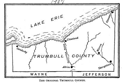
TRUMBULL COUNTY.
At the time of the organization of the
Northwest Territory
the state of Connecticut had laid claim
to that part of it lying
north of the forty-first parallel of
north latitude. In 1786 the
legislature of that state ceded all of
this claim to the United States,
except a strip 120 miles in length lying
next west of the Penn-
sylvania line. This became known as the
Western Reserve of
Connecticut, and was often called New
Connecticut, as that state
continued to enact laws for its
government, and exercise juris-
diction within it, as she did at home.
In May, 1800, her legis-
lature renounced jurisdiction to this
Reserve, and conveyed the
same to the United States. It then
became in order for St. Clair,
the territorial governor, to create a
county government for it.
Before this, it had been parts of the
counties of Jefferson and
Wayne. July 10, 1800, St. Clair placed
all of the Reserve into
the county of Trumbull. The new county
embraced all of the
territory north of the forty-first
parallel, lying within a distance
|
348 Ohio Arch. and His. Society Publications.
of 120 miles west of the Pennsylvania line. It was named in honor of Governor Trumbull of Connecticut, who was the execu- tive of that state at the time the cession was made. The county seat was located at Warren. |
|
|
|
CLERMONT COUNTY. The next county which St. Clair organized was Clermont. The date of his proclamation for the purpose was December 6, 1800. It was taken from the county of Hamilton. The county seat was located at Batavia. The origin of the name of the county has not been preserved, but the presumption is that it was derived from Clermont in France.
FAIRFIELD COUNTY. December 9, 1800, but three days after the organization of Clermont county, St. Clair issued a proclamation for the organi- zation of Fairfield county. It was taken from the counties of Washington and Ross, about one-half from each. St. Clair gave it the name of Fairfield, from the beauty of its fair lands. The county seat was located at Lancaster. |
|
The Evolution of Ohio Counties. 349
BELMONT COUNTY.
Belmont county was formed by St. Clair, September 7, 1801. It was made up of the northern part of Washington and the southern part of Jefferson county. Belmont is derived from two French words signifying a fine mountain. The surface is very hilly and the land very picturesque. St. Clairsville, the county seat, derives its name from Governor St. Clair. This was the last county to be formed by the proclamation of the territorial governor. Subsequent to this, under the new state government, counties were formed, and their boundaries changed, by act of the state legislature. |
|
|
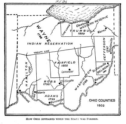
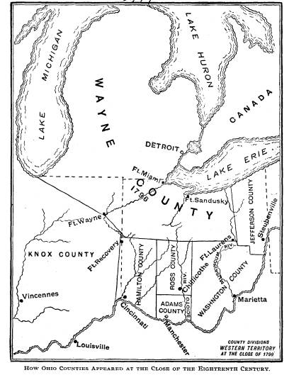
350
Ohio Arch. and His. Society Publications.
This completes the evolution of Ohio
counties to the time
the state was formed. The Convention
which met November 1,
1802, to frame the first state
constitution was composed of thirty-
five members, apportioned to the
counties appearing on the above
map, as follows: Adams, three Belmont
two, Clermont two, Fair-
field two, Hamilton ten, Jefferson five,
Ross five, Trumbull two,
and Washington four. The northwestern
part of the state, by
the treaty of Greenville, August 3,
1795, had been allotted to the
Indian tribes, as a reservation, and was
unsettled by the Whites.
The seat of government of the county of
Wayne was at Detroit,
and when Ohio was being formed, as the
greater part of that
county would be in the Indian Territory,
it was given no represen-
tation in the convention.
These counties have been divided and
disintegrated, until
from the nine organized counties and the
Indian reservation that
came to the state when formed, the
number has grown to eighty-
eight. When this article was begun it
was the intention to go to
the end, and thus evolve the present
county map of the state, but
the time allotted has been too brief to
allow it, and we stop at this
convenient point, hoping to be able to
present the others in some
subsequent report.