Ohio History Journal
ZANE'S TRACE.*
CLEMENT L. MARTZOLFF.
The first road maker in our country was
the buffalo. His
successor was the Indian. Instinct told
the buffalo where to
make his path. Nature, which is another
name for instinct,
prompted the red man in marking his
trail. The white man
came and reason told him that the
red man and the buffalo
had selected the driest, shortest and
most practicable routes of
migration. This is only another way of
saying that the geog-
raphy of any country determines its
history.
Every institution which we have is the
product of the
centuries. History therefore is the
finding of the factors. Ohio,
occupying the enviable position she
does, in the sisterhood of
Commonwealths must consequently have a
remarkable history.
In studying the evolution of our state
the author believes
that he has discovered a prime factor of
its development in
Zane's Trace.
Behind the historical event stand the
actors. In the consid-
eration of the present subject there are
two.
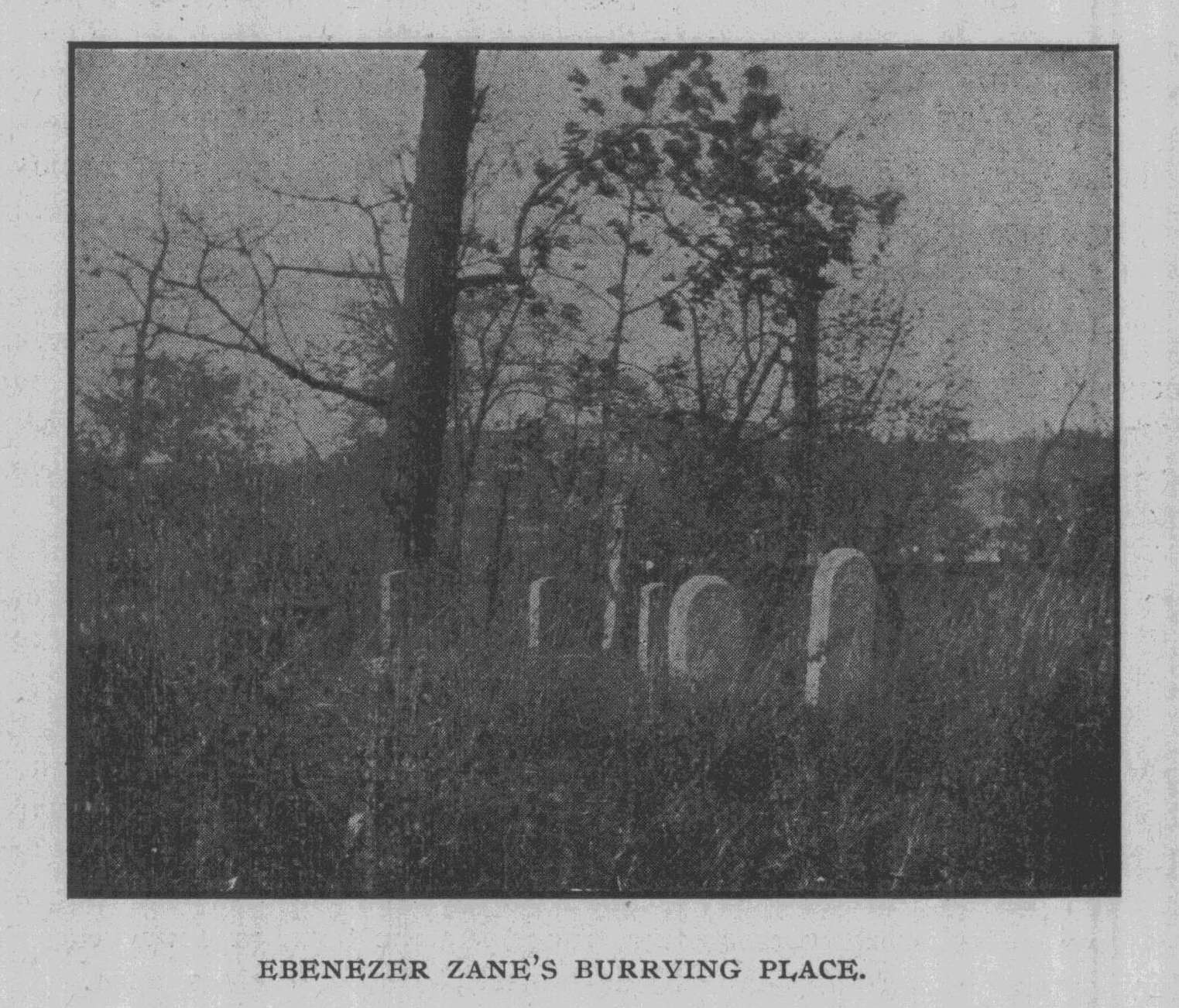
On the outskirts of the village of
Martin's Ferry, Belmont
County, Ohio, is an old neglected
grave-yard situated upon a
terrace overlooking the Ohio River.
Within the barbed wire
enclosure is another, surrounded by a
substantial brick wall,
capped with stone. An iron gate on one
side allows you means
of ingress. The interior of this
enclosure is a maze of briers
and brambles. It is the private burial
ground of the Zane family.
There are monuments in various stages of
decay. Upon a stone
tomb, about three feet in height rest
four slabs, on one of
these are the words:
*In the preparation of this article, I
wish to acknowledge my grati-
tude to John B. Overmeyer, Somerset, 0.;
Chas. W. Hunt, Somerset, 0.;
Judge M. Granger, Zanesville, 0.; Col.
Chas. C. Goddard, Zanesville, 0.;
Captain N. W. Evans, Portsmouth, 0.; Mr.
Sarchett, Cambridge, 0.;
and Judge Cranmer, Wheeling, W. Va.
( 297 )
298 Ohio Arch. and Hist. Society Publications.
"In memory of Ebenezer Zane, who
died 19th
November, 1812, in the 66th year of his
age. He was
the first permanent inhabitant of this
part of the
Western World, having first begun to
reside here in
the year 1769. He died as he lived, an
honest man."
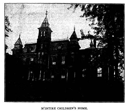
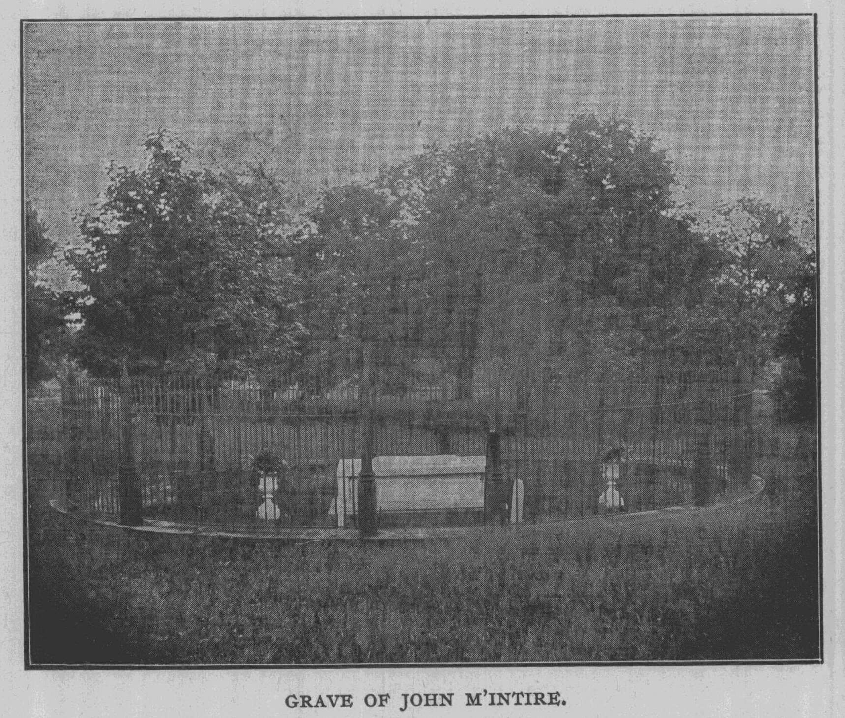
In the prosperous city of Zanesville, on
a hill overlooking
what is known as the Terrace, is the
John McIntire Children's
Home. In a beautiful grove of trees,
just as you begin to ascend
the hill, your attention is attracted to
a tall iron fence inclosing
a tomb. On the marble slab is the
inscription:
"John McIntire, 1738-1815."
1The Zane family originated in Denmark.
They certainly
possessed one characteristic of their
Danish ancestry - their rov-
ing, adventurous disposition. At an
early date a scion of the
family went to England and it is from
him that the American
Zanes trace their descent. When William
Penn came to America,
he was accompanied by one Zane, who was
also a Quaker. In
the new settlement it seems that he was
somewhat prominent.
Zane street in Philadelphia was named
for him. It is said that
he became obnoxious to his Quaker
brethren. The cause of
this disaffection is not known. It may
be that the Quakers were
obnoxious to him. Philadelphia may have
become too crowded
for a man of his temperament. He may
have longed for the free-
dom of the woods. At any rate he left
Quakerdom and settled
on the south branch of the Potomac, near
what is now Moorfield.
Hardy County, W. Va. but then known as
Berkeley County, Vir-
ginia. Here the Zanes became
characteristic woodmen, and pio-
neers. They were hunters, scouts and
Indian fighters. They
possessed that stern sense of justice
that such conditions of life
can only develop. The social condition
of that pioneer day was a
distinct evolution of its own. There was
no room for the puny
weakling. It was a case of the
"survival of the fittest." There
was no room for sentiment. It was a
battle royal for existence.
The weak and sentimental succumbed or
went back to the settle-
1Wiseman's Pioneer, Fairfield County.
|
Zane's Trace. 299
ment. The strong remained or pushed further into the interior. There were wild nature, wild beasts and wild men to conquer. Even a Quaker under such conditions could lay aside his sombre gray and from beneath his broad brimmed hat sight along the barrel of his rifle and shoot men. In summing up the character of the Zanes it is enough to say that in this pioneer conflict they not only survived but pushed on toward the setting sun. Ebenezer Zane was born in the Potomac Valley, October 7th, 1747. He had four brothers and one sister. 1 The assertion that Ebenezer Zane together with two brothers, was a captive of the Wyandottes for thirteen years has not sufficient evidence behind it to give it credence. His wife was Elizabeth McCul- |
|
|
|
loch. She was a sister of the McCulloch brothers who were no less renowned as frontiersmen than the Zane family. It is said that she was in every way an estimable helpmeet to her husband. It was in 1767 that Ebenezer Zane and his brothers, Silas and Jonathan, began to make preparations for a journey to the west. The following spring with all of the family and property, which included some negro slaves, they set out on the old Cumberland Trail, to what is now Brownsville, Pa. The next year they took up the journey again and at the mouth of the Wheeling Creek See Denny's Journal. |
300 Ohio Arch. and Hist.
Society Publications.
on the Virginia side of the Ohio, they established their homes
thus becoming the founders of Wheeling
in 1770. Their fam-
ilies came the next year. However the
town was not regularly
laid out till 1793.
"Zane had chosen one of the
strategic points of the Ohio
Valley, though this could hardly have
been known to him at
the time. All that he probably cared to
know was that he had
found an advantageous spot to trade with
the interior of Ohio.
It was where the crowding hills left
scant room for a town site,
but when the Ohio was low, it was
practically the head of nav-
igation, even for flat and keel
boats. Of course its further
advantage as a point of departure for
the east had not then been
discovered, or that other advantage
which it presently assumed
as a stopping place for emigrants
descending the river."-(From
Abbott's History of Ohio.)
l Zane soon had title to all the land
where Wheeling now is,
Wheeling Island in the Ohio River, up
the Ohio Valley as far
as Burlington, and up Wheeling Creek on
the Ohio side for quite
a distance.
He became the recognized leader of the
new settlement.
He possessed the rare elements of
leadership. He knew the
woods, the Indians, and the pioneer. 1
In this he was aided by
his brothers, who carried into execution
his plans. In 1806 he
laid out the town of Bridgeport, on the
north side of Wheeling
Creek, on the line of the old
"Indian Trail." He planted the
first seedling nursery in the upper Ohio
Valley, on Wheeling
Island in 1790. He even
originated a new species of fruit. "Zane's
Greening" was for many years, a
popular apple in eastern Ohio.2
1Among the first to brave the dangers of
pioneer life was James
Maxwell, who was obliged to leave his
home in Virginia to avoid prose-
cution for a murder of which he was
subsequently proven innocent. He
was a cousin of Col. Zane and it was the
Zane settlement he attempted
to reach to find security; but such was
not the case, as Zane ordered him
to leave at once or he would himself
convey him to Berkeley County, Vir-
ginia, where the crime was said to be
committed." * * *
Later. "Zane recommended him to
Capt. Hamtramck as a scout
for the new fort (Steuben). Zane said his
eye was keener and his tread
lighter than those of the most wily
savage." - Hunter's Pathfinders, Jeff-
erson County.
2 History
of Upper Ohio Valley.
|
Zane's Trace. 301
In the Journal of John Matthews in which he keeps a record of the survey of the Seven Ranges, he frequently men- tions the name of Zane, e. g.,"went to home of Col. Zane for dinner." "Esq. Zane brought us word of an Indian being killed." "Pitched tent near Esq. Zane's store," etc. In 1774 occurred what is known as Dunmore's War-short of duration, but pregnant with mighty results. Wheeling was the original storm center of this conflict. Twenty-six years after- |
|
|
|
ward Ebenezer Zane wrote to Hon. John Brown, one of the sena- tors in Congress from Kentucky, as to the causes of this war. The letter is dated at Wheeling, February 4th, 1800, and is as follows :1 "I was myself, with many others, in the practice of making im- provements on lands upon the Ohio for the purpose of acquiring rights to the same. Being on the Ohio, at the mouth of Sandy Creek, in com- pany with many others, news circulated that the Indians had robbed some of the land jobbers. This news induced the people generally to 1 History of the Upper Ohio Valley. |
302 Ohio
Arch. and Hist. Society Publications.
ascend the Ohio. I was among the number.
On our arrival at Wheeling,
being informed that there were two
Indians with some traders near and
above Wheeling, a proposition was made
by the then Captain Michael
Cresap2 to waylay and kill
the Indians upon the river. This measure I
opposed with much violence alleging that
the killing of those Indians
might involve the country in a war. But
the opposition party prevailed
and proceeded up the river with Captain
Cresap at their head.
In a short time the party returned and
also the traders in a canoe, but
there were no Indians in the company. I
enquired what had become of
the Indians and was informed by the
traders and Cresap's party that they
had fallen overboard. I examined the
canoe and saw much fresh blood
and some bullet holes in the canoe. This
finally convinced me that the
party had killed the two Indians and
thrown them into the river.
"On the afternoon of the day this
action happened, a report pre-
vailed that there was a camp or party of
Indians on the Ohio below and
near Wheeling. In consequence of this information Captain Cresap
joined by a number of recruits,
proceeded immediately down the Ohio
for the purpose, as was then generally
understood, of destroying the
Indians above mentioned. On the succeeding day Captain Cresap
and his party returned to Wheeling. It
was generally reported by the
party that they had killed a number of Indians.
Of the truth of this
report I have no doubt as one of
Cresap's party was badly wounded
and the party had a fresh scalp and a
quantity of property which they
called Indian plunder. At the time of
the last mentioned transaction
it was generally reported that the party
of Indians down the Ohio were
Logan and his family; but I have reason
to believe that this report was
unfounded.
"Within a few days after the
transaction above mentioned a party
of Indians were killed at Yellow Creek.
But I must do the memory of
Captain Cresap the justice to say that I
do not believe that he was pres-
ent at the killing of the Indians at
Yellow Creek. But there is not the
least doubt in my mind that the massacre
at Yellow Creek was brought
on by the action above stated.
All the transactions which I have
related happened in latter end
of April, 1774; and there can scarcely
be a doubt that they were the
cause of the war which immediately
followed, commonly called Dun-
more's War.
I am with much esteem, yours etc.,
EBENEZER ZANE."
2"The
settlers began to gather at Wheeling, the rush being from all
points, none of them agreeing to accept
the protection offered by scouting
parties from Ft. Pitt and return to
their plantations. Cresap was elected
leader and on April 21, received a
letter from Ft. Pitt confirming the
rumors of impending war. A counsel was
held and Cresap's men at once
declared war against the Indians."
- Hunter's Pathfinders of Jefferson
County.
Zane's Trace. 303
Lord Dunmore, the titled governor of the
old Dominion, de-
termined to carry the war into the
enemy's country. He or-
dered Colonel Angus McDonald to raise a
regiment for imme-
diate service.
With a force of four hundred Viriginians
McDonald crossed
the mountains to Wheeling, where he
built Fort Finncastle, in
honor of Lord Dunmore. On the 25th
of July, he floated down
the Ohio to Captina Creek and there with
Jonathan Zane, as
guide they started for the Indian
villages on the Muskingum.
At the mouth of the Wappatonica, near
Coshocton, they destroyed
towns and growing crops and the Indians
for the time were
subdued.
During this war Col. Ebenezer Zane was
made Disbursing
Agent of the Militia at Wheeling and was
practically the com-
mandant of Fort Finncastle.
1Two years later when Virginia renounced
her allegiance to
the crown and deposed her royal
governor, Col. Zane, true patriot,
as he was, changed the name of his fort to
that of Fort Henry,
for the first governor of the
Commonwealth. There was no regu-
lar militia to defend it. The settlers
who were driven within its
walls for protection, composed its only
garrison.
Here on the last day of August, 1777,
four hundred Indian
warriors, led by that prince of
cut-throats, Simon Girty, under
the royal insignia of King George, with
the consent and approval
of the "Hair-buying" 1
scoundrel at Detroit, appeared before the
walls and gave the garrison fifteen
minutes in which to sur-
render.
Col. Zane replied that before they would
surrender or ab-
jure the cause of liberty that every
man, woman and child within
the fort would rather perish. There were
but twelve men and
boys besides the women, in the fort.
Col. Zane gave everybody
work. The women made the bullets and
they helped to shoot
them. The siege continued for
twenty-three hours until rein-
forcements came and the Indians
despaired of reducing the fort.
But all of the houses without the
fortification were burned arid
many of the settlers' cattle and hogs
were driven away.
1Hunter's Pathfinders.
304 Ohio Arch. and Hist. Society Publications.
The last battle of the American
Revolution was fought here
in 1782.
The conflict is described by Col. Zane
in a letter sent to
Gen. Irvin by the hands of Mr. Loyd.
WHEELING, 14th of September, 1782.
SIR:--On the evening of the 11th instant
a body of the enemy
appeared in sight of our garrison. They
immediately formed their lines
around the garrison, paraded British
colors and demanded the fort to be
surrendered, which was refused. At
twelve o'clock at night they rushed
hard upon the pickets, in order to storm
but were repulsed. They made
two other attempts to storm before
daybreak but to no purpose. About
eight o'clock next morning there came a
negro from them to us and
informed us that their force consisted
of a British captain and forty
regular soldiers and two hundred and
sixty Indians.
The enemy kept up a continual fire the
whole day. About ten
o'clock at night they made a fourth
attempt to storm to no better pur-
pose than the former.
The enemy continued round the garrison
till the morning of the
13th instant when they disappeared. Our
loss is none. Daniel Sullivan
who arrived here in the first of the
action is wounded in the foot. I be-
lieve they have driven the greatest part
of our stock away and might, I
think, be overtaken. I am with due
respect,
Your obedient servant,
EBENEZER ZANE.
Addressed, William Irwin, Brigadier
General, Commanding at Pitts-
burg."
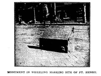
The fort stood at what is now the corner
of Main and Elev-
enth streets in Wheeling. The spot is
marked by a stone, bear-
ing these words:
"By authority of the State of West
Virginia, to commemorate the
siege of Fort Henry, September 11th,
1782, the last battle of the American
Revolution, this tablet is here placed.
S. H. GRAMM,
W. W. JACKSON,
T. M. GARVIN,
G. W. ATKINSON, Governor. Committee.
Col. Zane's house stood about sixty
yards without the fort.
He himself remained in his own building
which was a sort of
1History of Upper Ohio Valley.
Zane's Trace. 305
block house. His three brothers, Silas,
Jonathan and Andrew
were within the fort as was also their
sister Elizabeth, a young
woman of twenty-three. It was on this
occasion that she per-
formed that feat, famous in song and
story.
"This dauntless pioneer maiden's
name
Is inscribed in gold on the scroll of
fame.
She was the lassie who knew no fear
When the tomahawk gleamed on the far
frontier.
If deeds of daring should win renown,
Let us honor this damsel of Wheeling
town,
Who braved the savages with deep
disdain,-
Bright-eyed, buxom Elizabeth Zane.
'Tis more than a hundred years ago,
They were close beset by the dusky foe;
They had spent of powder their scanty
store,
And who should the gauntlet run for
more?
She sprang to the portal and shouted,
'I!
'Tis better a girl than a man should
die!
My loss would be but the garrison's
gain.
Unbar the gate!' said Elizabeth Zane.
The powder was sixty yards away
Around her the foemen in ambush lay;
As she darted from shelter they gazed
with awe
Then wildly shouted, 'A squaw!' 'a
squaw!'
She neither swerved to the left or
right,
Swift as an antelope's was her flight.
'Quick ! open the door !' she cried
amain.
'For a hope forelorn! 'Tis Elizabeth
Zane.'
No time had she to waver or wait
Back must she go ere it be too late;
She snatched from the table its cloth in
haste
And knotted it deftly around her waist,
Then filled it with powder-never, I
ween,
Had powder so lovely a magazine;
Then, scorning the bullets' deadly rain,
Like a startled fawn, fled Elizabeth
Zane.
She gained the fort with her precious
freight;
Strong hands fastened the oaken gate:
Brave men's eyes were suffused with
tears
That had been strangers for many years.
From flint-lock rifles again there sped
20 Vol. XIII.
306 Ohio Arch. and Hist. Society Publications.
'Gainst the skulking red skins a storm
of lead.
And the war-whoop sounded that day in
vain,
Thanks to the deed of Elizabeth Zane.
Talk not to me of Paul Revere
A man, on horseback, with naught to
fear;
Nor of old John Burns with his bell
crowned hat-
He'd an army to back him, so what of
that?
Here's to the heroine, plump and brown,
Who ran the gauntlet in Wheeling town;
Hers is a record without a stain,-
Beautiful, buxom, Elizabeth Zane."
-John S. Adams in St. Nicholas.
1The heroine of this poem afterwards lived about two
miles above Wheeling on the Ohio side.
She was twice married,
first to Mr. McLaughlin and then to Mr.
Clark. She died in
1847 at St. Clairsville, Belmont County,
and is buried in the
Zane burial ground, but no monument
marks the spot.2
It is evident that much of Zane's
knowledge of the Ohio
country was derived from his brother
Jonathan, who it seems
had traveled over a considerable portion
of eastern Ohio. In
1785 General Parsons from Massachusetts,
afterwards one of
the judges of the territory north of the
Ohio, while on an in-
spection tour in the interests of the
then proposed Ohio Company,
made a trip up the Muskingum River. At
the "Saltlick," Dun-
can's Falls, ten miles below the mouth
of the Licking, he met
and conversed with Jonathan Zane about
the Ohio Country;
Zane was there making salt.3 Dr. Cutler
himself was advised by
Col. Zane to make his proposed
settlement on the Muskingum
north of the Licking.
4When Gen. William Crawford led his
expedition against
the Sandusky Indians, Jonathan Zane
served in the capacity
of scout and guide. He was invited to a council before the
battle and because of his superior
knowledge of Indian prowess
and tactics he advised a retreat. His
advice was not acted upon
and the result was fatal to the pioneer
army.
1Howe's Historical Collection.
2Wiseman's Pioneers of Fairfield County.
3Hildreth's Pioneer History.
4Wiseman's Pioneers of Fairfield County.
|
Zane's Trace. 307 No better man than Ebenezer Zane could have been found to cut a road through Ohio. His influence in the new settlement, his wealth and his general knowledge of the country made him the logical man to assume the responsibility. His brother Jona- |
|
|

|
than was his right hand man in everything he did, and this was a great aid to him in all of his undertakings. The first pioneers to our state settled along the Ohio river. The great interior was still the hunting grounds of the Indian. |
308 Ohio Arch. and Hist. Society Publications.
The first decade after the Revolution
was not a propitious time
to make settlements too near the
frontier border. It was not till
after the decisive victory of Wayne in
1794 that the influx of
settlers began to ascend the streams, to
any material extent.
Wheeling was situated where this pioneer
army was apt to di-
verge from the established water route.
Knowing the land as well as he did, it
was natural that Col.
Zane should advise people to settle upon
the Muskingum.
Neither does it take such a great
stretch of the imagination to
see how he might conceive the blazing of
a trail, and the cutting
of a road to reach these new lands. A
road starting from his
town would make it an important factor
in the development of
the Ohio country.
There was another thing in his favor.
There might be an-
other outbreak of the Indians. Governor
St. Clair had officially
reported to Congress concerning the
absence of roads and pointed
out their importance in the moving of
troops.
Col. Zane had already blazed a trail
from Pittsburg to
Wheeling and its value to the new
settlers only made him more
sanguine regarding a road connectiong
the Ohio with the Ohio
and running through what was then the
garden spot of the state.
It was early in 1796 that Ebenezer Zane
presented a me-
morial to Congress stating his plans. On
Friday, March 25th
of that year.1
"Mr. Brown (Kentucky) presented the
memorial of Ebenezer Zane
praying liberty to locate such military
bounty lands, lying at the cross-
ings of certain rivers, mentioned in the
said memorial as may be neces-
sary to enable to establish ferries and
open a road through the territory
Northwest of the Ohio to the state of
Kentucky, which memorial was
read.
"Ordered that it be referred to
Messrs Brown, Ross and Livermore
to consider and report thereon to the
Senate."
Wednesday, April 6th, 1796.
The Committee to which was referred the
petition of Ebene-
zer Zane states:
"That the petitioner sets forth that
he hath at considerable ex-
pense, explored and in part opened a
road, northwest of the river Ohio,
between Wheeling and Limestone, which
when completed will greatly
1 History
of Congress.
Zane's Trace. 309
contribute to the accommodation of the
public as well as individuals. But
that several rivers intervening, the
road proposed cannot be used with
safety until ferries shall be
established thereon.
"That the petitioner will engage to
have such ferries erected pro-
vided he can obtain a right to the land
which is now the property of
the United States. And therefore prays
that he may be authorized to
locate and survey-at his own
expense-military bounty warrants upon
as much land at Muskingum, Hockhocking
and Scioto Rivers as may be
sufficient to support the necessary
establishments. And that the same be
granted to him by the United States.
"That they having received
satisfactory support of the above state-
ment are of opinion that the proposed
road will be of general utility,
that the petitioner merits encouragement
and that his petition being
reasonable, ought to be granted.
"The committee therefore submit the
following resolution:
"Resolved, That the petition of Ebenezer Zane is reasonable; that
he be authorized to locate warrants
granted by the U. S. for military
services upon three tracts of land, not
exceeding one mile square each,
at Muskingum, Hock-hocking and Scioto
where the proposed road shall
cross those rivers, for the purpose of
establishing ferries thereon: and
that leave be given to bring in a bill
for that purpose.
"On motion it was agreed that this
report be adopted and that the
committee who were appointed on the
petition be instructed to bring in
a bill accordingly.
"Mr. Brown from the Committee
instructed for the purpose reported
a bill to authorize Ebenezer Zane to
locate certain lands in the territory
northwest of the river Ohio, which was
read and ordered to a second
reading Thursday, April 7th, 1786.
"The bill to authorize Ebenezer
Zane to locate certain lands in the
territory of the United States,
northwest of the river Ohio, was con-
sidered:
"Ordered, That the second reading of this bill be the order of
the
day Monday next.
(Nothing seems to have been done that
day.)
Wednesday, April 13th, 1796.
"The bill to authorize Ebenezer
Zane to locate certain lands in
the territory of the United States,
northwest of the river Ohio, was read
the second time and referred to the
Committee appointed on the 8th
instant, on the bill entitled, 'An act
providing for the sale of lands of the
United States in the territory northwest
of the river Ohio and above
the mouth of the Kentucky River' to
consider and report thereon to the
Senate.
Wednesday, April 27th, 1796.
"Mr. Ross from the committee to
whom was referred the bill 'to
authorize Ebenezer Zane to locate
certain lands in the territory of the
United States Northwest of the river
Ohio' reported amendments thereto
310 Ohio Arch. and Hist. Society
Publications.
which were read and adopted and the bill
was ordered to a third read-
ing.
Thursday, April 28th, 1798.
"The bill to authorize Ebenezer
Zane to locate certain lands in the
territory northwest of the river Ohio
was read the third time and being
further amended was passed.
"An act to authorize Ebenezer Zane
to locate certain lands in the
territory of the United States,
northwest of the river Ohio.
"Be it enacted, etc. That upon the
conditions hereinafter men-
tioned, there shall be granted to
Ebenezer Zane three tracts of land, not
exceeding one mile square each, one on
the Muskingum River, one on the
Hock-hocking River and one other on the
north bank of the Scioto River
and in such situations as shall best
promote the utility of a road to be
opened by him on the most eligible
route, between Wheeling and Lime-
stone, to be approved by the President
of the United States or by such
person as he shall appoint for such
purpose.
"Provided such tracts shall not
interfere with any existing claim,
location or survey nor include any salt
spring, nor the lands on either
side of the Hock-hocking River at the
falls thereof.
"Sec. 2. And be it further enacted,
That upon the said Zane's pro-
curing at his own expense the said
tracts to be surveyed in such way
and manner as the President of the
United States shall approve and
returning into the Treasury of the
United States plats thereof, together
with warrants granted by the United
States for Military land bounties
to the amount of the number of acres
contained in the said three tracts;
and also producing satisfactory proof by
the first day of January next
that the aforesaid road is opened and
ferries established upon the rivers
aforesaid, for the accommodation of
travelers and giving security that
such ferries shall be maintained during
the pleasure of Congress, the
President of the United States shall be
and hereby is authorized and
empowered to issue letters patent in the
name and under the seal of the
United States, thereby granting and
conveying to the said Zane and his
heirs the said tracts of land located
and surveyed as aforesaid; which
patents shall be countersigned by the
Secretary of State and recorded
in his office.
"Provided always, That the rates of ferriage at such ferries shall
from time to time be ascertained by any
two of the judges of the territory
Northwest of the river Ohio, or such
other authority as shall be ap-
pointed for that purpose.
Thursday, April 28th, 1796.
"A bill was received from the
Senate authorizing Ebenezer Zane
to locate certain lands northwest of the
river Ohio which was read and
referred.
May 2d, 1796.
"Mr. Orr, Chairman of the Committee
to whom was referred the
bill from the Senate authorizing
Ebenezer Zane to locate certain lands
|
Zane's Trace. 311
northwest of the river Ohio, reported the bill without amendment. Re- ferred to a committee of the whole. Wednesday, May 11th, 1796. "The bill authorizing Ebenezer Zane to locate certain lands in the Northwestern Territory was read a third time and passed." Approved, May 17th, 1796. If Col. Zane could not have accomplished the work he did without the help of his brother Jonathan, it is equally certain that he would have done much less had he not been assisted by his son-in-law John McIntire, who now appears as a factor in the achievements of Ebenezer Zane. |
|
|
|
Born of Scotch parentage in Alexandria, Virginia, 1759, John McIntire came to Wheeling in the capacity of a shoemaker. Possessed of a handsome figure and much native ability and address, he succeeded in winning the affections of Sarah Zane, the second daughter of the Wheeling proprietor. She was at this time but fifteen years of age and over twenty years younger than her gallant admirer. The old adage of "true love running not smooth," was verified in this case to an ultimate certainty. For Col. Zane and his wife opposed the match with great vehe- mence. But the result is the same old story. They were married in spite of parental objection. During the wedding festivities, the father-in-law absented himself, by taking a hunting trip. The lWiseman's Pioneers Fairfield County. |
312 Ohio Arch. and Hist. Society Publications.
mother-in-law used her slipper over the
shoulders of her daughter
to show her disapproval.
It is said that sometime after the
marriage Col. Zane in pass-
ing the cabin of McIntire saw his
daughter chopping wood. He
did not hesitate to remind her that if
she had stayed at home
she would not have had to do such manual
labor. But everything
was righted before long and McIntire
became a favorite of Mr.
Zane. Now that he had the contract to
cut a road through the
Ohio woods, it was but natural that he
should leave the real
work to this son-in-law and his brother
Jonathan.
The experience of Jonathan Zane stood
him well in hand,
in the laying out of the road. The route
determined upon was
the result of his advice.
However Jonathan Zane was not the
originator of the route,
in its entirety, for the Indian had gone
over practically the same
ground, that the Trace afterward
covered. The work of blazing
trees and cutting out small undergrowth
and removing fallen
timber began in the summer of 1796.1
2 The
party consisted of Jonathan Zane, John McIntire,
John Green, William McCulloch, Ebenezer
Ryan and several
others whose names are not known.
John Green had charge of the pack
horses, that carried the
tent and provisions. Being also a boot
and shoemaker and not
used to handling the ax, he was selected
to kill game of which
there was an abundance. He was also the
cook and general ser-
vice man of the party. At night a fire
was built to keep away
beasts of prey and two men were kept on
watch for fear that a
straggling party of Indians might attack
them. But there was
no need of this precaution for the
spirit of the Ohio Indian had
been broken by Mad Anthony two years
before at Fallen Timbers
and the chances for attack were remote.
The route of Zane's trace followed
Wheeling Creek for about
seven miles, where it climbed the hill
and struck the ridge be-
1The marking was done with axes; and as
far as can be learned
now, it was never surveyed, or any part
of it returned to Congress or the
land office. No report of it was made or
can be found in the general
land office. CAPT. NELSON W. EVANS.
Portsmouth, Ohio.
Archives of Muskingum Pioneer Society.
Zane's Trace. 313
tween Wheeling Creek and McMahon's
Creek. Since the Na-
tional Road from Wheeling to Zanesville
is located approximately
upon Zane's Trace, we deem it proper to
describe its route in
reference to this road.
1 The
"Trace" from St. Clairsville, Belmont County followed
the ridge and crossed Big and Little
Still Water Creeks, gradu-
ally climbed along the side of the hill
to Morristown. From
Morristown it went north of the National
Road and also north
of Henrysburg, passed over the ridge at
Fairview, Guernsey
County, crossing the National Road at
this place and kept south
of the Pike following Putney Ridge which
divides Leatherwood
and Salt Creek tributaries of Will's
Creek, till about three miles
east of Washington, which is the oldest
town in Guernsey
County.
Following the divide to this town it
passed through it, at
an angle to the present street.2
Crossing the National Road here it kept
on the north side
for five miles, when it crossed to the
south again, about three
miles east of Cambridge and just east of
the Crooked Stone
Bridge. For a very short distance it
continued south of the
road, but crossed again to the north at
Stone Bridge, crossing
Cook's Run. The house standing above the
bridge is on the
"Trace," Old Wheeling Road and
National Road, but by means
of a "cut" is somewhat
elevated. From here it practically fol-
lows the National Road with only a
divergence of a few rods
until within one and a half miles east
of Cambridge. At this
point it veers to the north of the Pike,
and follows the ridge just
north of Wheeling street in Cambridge1
and just a little north
of Steubenville Avenue of the present
city.
It crossed Will's Creek at a point above
where the Baltimore
and Ohio Railway Bridge is now situated.
Later the crossing
was changed to the east opposite the
Marietta Depot. Here a
ferry was maintained and later a rude
log bridge was built by
General Biggs who owned the land upon
which the city of Cam-
1Sarchett.
2 (See
old street back of the present one.)
1The first tavern in Cambridge called
the Bridge House Tavern was
situated on the Trace.
314 Ohio Arch. and Hist. Society Publications.
bridge is built. Persons crossing this bridge were required
to
pay toll. The general afterward sold the
bridge to Beatty and
Gambier who laid out the city. In the sale the right to cross
the bridge free from toll was reserved
by the seller to himself
and his descendants forever.
From Will's Creek the Trace crossed
Crooked Creek Bot-
tom,2 then the National Road
where the Baltimore and Ohio Rail-
way now interescts it, and then
continued north of the Pike till
about five miles west of Cambridge and a
little west of Cassel
station, where it strikes the road
again. Just before striking the
Pike is the residence of Judge Speer.
This is situated on the
"Trace" and here the judge
kept a tavern. About a mile west
was another public house known as the
Grummond Tavern. Here
the "Trace" again crossed the
National Road and continued on
the south side of it till it reached New
Concord.
3 It
was at first determined to run the "Trace" along the li
of the old "Mingo Indian
Trail" from Cambridge. This would
2At Crooked
Creek, Mr. Sarchett says that the trace went between
two oak trees, so close together that
they were almost cut off by wagon
hubs.
3When Ebenezer Zane in 1797 surveyed his
road, he passed through
the territory now known as Union
township (Muskingum County), and
opened up a highway in the wilderness
along which the tide of emigration
passed.
"Old Wheeling Road surveyed by Zane
entered Union Township
(Muskingum County), in Township 1,
"Military Lands, on S. E. of Sec.
10, and passed in Range Six, now Perry
Township in the N. E. 1/4 of
Sec. 16."
"In 1827, the National Road was
surveyed. It entered the township
(Union), in S. E. 1/4 of Sec. 1, and
passed out on the N. W. 1/4 of Sec. 15.
The Wheeling Road (Zane's Trace), was
then abandoned."
"After the Cumberland Road had been
established the travel over
Zane's Trace was diverted toward
Columbus."
"So they started from the Schaffer
Meeting House in a south west
course until they came out by the Evans
and Irwin place on the National
Road, then to Mill Run, up Mill Run hill
south, then nearly due
west, then down the steep hill, where
the machine house now stands,
known as the Cochran Hill. Then they
crossed over to Sullivan street
between Dr. Brown's late residence and
the German Catholic Church;
down Main street to the foot, crossed
the Muskingum, south of Licking
Zane's Trace. 315
have made the crossing of the Muskingum
at Duncan's Falls,
ten miles below Zanesville. But the
superior water power at
the mouth of the Licking caused Jonathan
Zane to leave the
"Trail" when he reached Salt
Creek and instead of following
the "Trail" along that creek
he made a direct line for the Lick-
ing. He now crossed to the north of the
National Road till they
reached the Shaffer Meeting House, three
miles east of Zanes-
ville on the Adamsville Road. From here
they intended going
down Mill Run near the Indian trail,
then cross Mill Run near
the Iron bridge by the old blast
furnace, go south to the head of
Layhew's hollow, then southwest to the
foot of Market Street in
Zanesville. Finding that the proposed
town could not be laid
off to advantage, this idea was
abandoned.
1A survey of December 14th, 1798 of Zanesville Mile
Square
shows the line of the "Trace"
for a few miles east of Muskin-
gum River. This indicates that it
crossed the east line of Sec.
7, Township 12, Range 12 about one-third
mile south from N. E.
corner of said section. Ran northwest
across sections 7, 1 and 5
and interesected the south line of
United States Military Land
just east of Zane's Mile Square, crossed
the river within said
Mile Square and ran from the branch of
the Licking or Pataskala
Creek at its mouth, S.W. and then south,
again southwest cross-
ing Sections 1, 2, 11 and 14 in
Township 16, Range 13. It
crossed the south line of Sec. 14 about
one-third mile from S. W.
corner of said section. From
this point to where it reached
Island over Chap's Run; then south east
of the stone quarry; through
the Springer farm and then south along
the Maysville Pike."
"The old Indian Trail3 crossed
the (Muskingum) river at the foot
of Market street at the head of the
upper falls near where the old dam
was built. Then into West Zanesville
over Licking Island into South
Zanesville; up Chap's run; through the
Fair Grounds to the Maysville
Pike. This Indian Trail went from
Wheeling, through Zanesville to
Chillicothe and the Ohio River. It was a
well beaten path, several inches
deep.2 I have seen it many
times as it went through my father's farm
in Washington Township," (Muskingum
County.)
Judge Munson.
Zane's Trace did not follow an Indian
Trail at least east of the
Muskingum. HULBERT.
2 Writer in old Zanesville paper.
316 Ohio Arch. and Hist.
Society Publications.
the Perry2 County line it
followed approximately what is now
known as the Maysville Pike, through the
towns of White Cot-
tage and Fultonham.
It entered Perry county in Section 22, Madison Township,
crossed the Pike several times, then
took an almost westerly
course, leaving Somerset1 a
mile and a half to the south. Upon
striking the waters of Rush Creek they
went south along the
ridge east of the Creek until they
struck the Pike again just east
of Rushville5 in Fairfield
County. From here6 to Lancaster the
Indian trail leading from the Muskingum Valley by the great
Swamp and Standing Rock to the Pickaway
Plains was the
general route followed. The Maysville Pike is nearly on that
path.
In Lancaster it is pretty well
established that the "Trace"
followed Wheeling street as far as
Columbus street, where it
diverged to the south and crossed the
Hocking at Coate's cabin,
where there was a ripple or ford about
three hundred yards be-
low the turnpike bridge.
From Lancaster to Chillicothe4 with
but a few variations,
Zane's trace and the Maysville Pike are
identical. The route
is almost directly southwest, passing
through the famous Picka-
way Plains.
2"A road was cut in 1805 from
Putnam to intersect Zane's Trace in
Perry County. It passed diagonally
through the township (Newton),
from north-east to southwest." The
Indians used the Zane's Trail which
is a little south of this."-Old
writer.
1Zane's Trace passed School House No. 14
in Reading township,
Perry County.
5"It (Zane's Trace), passed through
the present villages of East
and West Rushville. Edward Murphy kept a
hotel near this road a short
distance from West Rushville. Among the
many distinguished guests
who partook of the bounties of this
hotel at various times were General
Andrew Jackson and Henry Clay. The old
hotel, now a rather dilapidated
structure is still standing
(1883)."-History Fairfield County.
6"The
first road in Pleasant Township (Fairfield County), was the
one leading from Wheeling to Maysville,
known as Zane's Trace. It
crossed the southern part of the
township."
4"A post-office was established at
Chillicothe in 1799. The mail was
brought from the east by Zane's Trace
and from the west by Todd's."
Zane's Trace. 317
2 From Chillicothe it followed Paint
Creek to the point where
it bends to the northwest, four or five
miles southwest of the
city.
Continuing in a southwesterly direction till just after it
crosses Black Run where it intersects
Todd's Trace up Morgan's
Fork of Sun Fish Creek.1 The remainder
of the route to Mays-
ville is virtually the same as that over
which Todd's army crossed
2Dawley's
Map of Virginia Military District.
1 In June, 1787, Colonel Robert Todd led
a party of mounted men,
about three hundred in number, on an
expedition against the Indians
at Old Chillicothe. The expedition
originated with Simon Kenton. He
was then at Washington, Kentucky, about
three miles back of Maysville.
The Indians were quite troublesome. They
would make raids, steal
horses and sometimes murder the
settlers. Kenton sent word to Col.
Robert Todd at Lexington, to bring as
many men as he could, and he
would bring a number and they would join
forces and destroy the In-
dian towns on the north fork of Paint
Creek. Kenton commanded a com-
pany and piloted the expedition, but
Col. Robert Todd had the command.
The party crossed the Ohio at the mouth
of Threemile Creek early
in the morning and followed it to near where
Bentonville now stands.
It passed south of the site of West
Union, and struck Lick Fork and fol-
lowed it to its mouth, where it camped
on the west side of Brush Creek.
The next day the expedition divided and
a part, that part under Kenton
went up Brush Creek to the site of
Fristoe Bridge, crossed Brush Creek
and went along the route of the present
turnpike to Sinking Springs and
thence to Cynthiana, Pike County, where
they camped the second night.
The right wing, under Col. Todd crossed
the creek at the site of the Iron
Bridge, and went up the old Chillicothe
road to Steam Furnace, to
near Cynthiana, where the forces joined.
From there they went by way
of Bainbridge to within three miles of
Old Chillicothe, where they
camped the third night out. About five
miles from Old Chillicothe, the
advance guard met four Indians, two of
whom they killed and the re-
maining two they captured. Kenton's
company then advanced to recon-
noiter, and sent word back to Col. Todd.
Kenton's party surrounded the
Indian camp but attacked before it was
light enough. Two Indians were
killed and seven made prisoners. The
remainder escaped. Col. Todd
with the force under his immediate
command, did not arrive in time to
participate in the attack. The town was
burned and all the crops de-
stroyed. The army encamped on the north
fork of Paint Creek the night
after the attack and the next day
started for their homes. Where they
camped on their return is not known, but
they took the route of the left
wing in returning. From the Ohio River
to Frankfort in Ross County,
the entire route was a virgin
wilderness. The party had to and did cut
out a road for themselves, their horses
and pack horses, all the way from
the Ohio River to Frankfort. The route
from the Ohio River to Old
318 Ohio Arch. and Hist. Society Publications.
ten years earlier, with the exception
from Locust Grove to a
point opposite Sinking Springs, Highland
County.3.
Between these two places the
"Trace" passed through Sink-
ing Springs, over the Todd War Road, and
crossed Brush Creek,
(the route of Christopher Gist, 1750,)
at Dunbarton in Adams
County.
It paralleled Brush Creek and one of its
southwestern tribu-
taries till it reached the junction of
the two streams forming the
Big Three Mile Creek which it followed
to the Ohio River oppo-
site Maysville or Limestone.1
Chillicothe by the route of the right
wing was afterwards called Todd's
Trace. That part of the route taken by
the left wing from the mouth of
Lick Fork by the Fristoe Bridge to
Cynthiana was called Todd's War
Road, and the name of that route,
"Todd's War Road," was given it by
Gen. Simon Kenton. * * * * After Zane's
Trace was laid out in
1797, Todd's Trace was forgotten except
as used in surveys made be-
tween 1787 and 1797, but the route of
Todd's War Road was the one used
by the stages from the time they began
to run."-N. W. Evans, Ports-
mouth, Ohio.
3"So far as the Trace went through
Adams County, it followed
the general course of Todd's Trace,
except between Bentonville and West
Union, where it was located further
north and east; and at the crossing
of Brush Creek, it went up by Steam
Furnace. The first settlers in it
were John Treber and Andrew Ellison, who
located on it in the spring
of 1798 on Lick Fork. These two
locations are the earliest known on
the line of the Trace in Adams County.
They are supposed to have set-
tled there in order to kill plenty of
game.
Zane's Trace was the usual route from
Maysville, Kentucky to Chil-
licothe, Ohio, from 1797 until about
1820. When first opened, it only
afforded a passway for persons on
horseback and packhorses. The first
man to ever pass over with a team was
William Craig, who drove a
wagon and a team of horses through from
Maysville to Chillicothe. This
was in 1798, and he had to cut his way
through for the whole distance."-
Nelson W. Evans.
"The Maysville and Zanesville
turnpike was constructed along the
general route of the old post road over
Zane's Trace passing through
Bradyville, Bentonville, West Union,
Dunkinsville, Dunbarton, Palestine,
Locust Grove and Sinking Springs."-
History Adams County, (Evans).
1"Zane's Trace commenced opposite
Maysville, came up through
Adams county to the ridge in Sun Fish
township, along which it continued
till it reached Byington; thence down
Sun Fish Creek to Big Spring;
thence up Kincaid's Fork to Lunbeck's
Hill and along that ridge in an
|
Zane's Trace. 319
The "Trace" was not completed within the time specified in the Congressional Act. It could hardly be expected when we consider that it covered a distance of something over two hundred miles. While the road was a mere indicator of direction and it followed the ridges where the undergrowth was scantier, yet |
|
|
|
there were many obstacles to overcome and it was not till well into the summer of 1797 that it was finished. It is said that John McIntire met with quite a severe acci- dent on the route between Zanesville and Limestone. While load- ing his gun the stock slipped off a root and the contents went through his right hand crippling it for life.
easterly direction till it passed Mr. Gaull's, in Perry township (Pike county); thence down Paint Valley to Chillicothe or Indian Old Town." - History of lower Scioto Valley. |
320 Ohio Arch. and Hist.
Society Publications.
2This "Trace" only a bridle path as made by
Zane soon be-
gan to be used. At wet crossings
saplings known as "corduroys"
were laid. The flood of immigration from
tide water poured
through this narrow sluice and gradually
widened it. It was for
years the only thoroughfare east or
west. It was so constantly
used that at times and places it was
worn into ruts so deep that
a horse could have been buried in some
of them. Travelers soon
learned to go round these places. It is
said that before the road
was accepted Zane was required to drive
a wagon over it. We
doubt this and place it along side of
the other traditionary state-
ments that grow up around historical
events. It has been fur-
ther stated that when he attempted to go
over his "Trace" with
the wagon it could not be done.
Pack horses were driven in lines of ten
and twelve. They
were tied together so that one driver
could handle them all.
Each animal carried about 200 pounds. A
large forked limb was
obtained and was cut off just below the
fork and then each limb
was cut off about six inches from the
crotch and trimmed down to
the required dimensions to accommodate
the load to be carried
upon it. Then a flat smooth board was
strapped on the horses'
back with a sheep skin pad under it. The
art of making pack
saddles became quite a backwoods
industry.
As settlements grew up along the line of
the Trace improve-
ments were quickly made in the route and
in the condition of
the road.
The "Trace" evaded the marshy
bottom lands. Neither did
it go around the hills, for digging
would have to be done, but it
climbed the hills, often in seemingly
inaccessible places. But it
formed the nucleus of the only highway
for forty years, along
which passed the trade and commerce of
the country.
1The eastern part of this blazed trail
as has been intimated
was along the route of an old Indian
thoroughfare. Before
Zane had been employed, the white
settler and trader had passed
along this bloody path, the scene of
many hairbreadth escapes
and thrilling adventures, the memory of
which still lingers in
the traditions of the people, because
from father to son is told
2Drake's Making of Ohio Valley States.
1 History of Upper Ohio Valley.
|
Zane's Trace. 321 again and again, before the fireside, the achievements of the "Heroes of the Forest." "Zane's Trace" might be rightfully considered as the first declaration of the principle of "Internal Improvements." It is true Ohio was not yet a state. The National Government was still the sole power of authority. Possibly a few years later the project would have been opposed by politicians who read dire calamity in "internal improvements." |
|
|
|
The route of the "Trace" determined the location of the home of the pioneer. The settler's cabin soon evolved into the tavern and the tavern soon became the center of a cluster of houses and a town had been born. At the crossing of a stream a ferry might be maintained. The ferryman might also be the proprietor of a public house. A small stock of goods could be kept for sale and there we have the germ of another town. |
322 Ohio Arch. and Hist. Society Publications.
The first home within the boundary of
Perry Township,
Muskingum County, was by James Brown who
came from Water-
ford, Washington County, in 1803,
built a cabin and opened
hotel where Zane's Trace crossed Big
Salt Creek.2
In 1804 Andrew Crooks opened a
wagon road along the
Trace from Zanesville to where it
crossed Jonathan's Creek 1 in
Newton Township and opened a public
house that for many
years was known as Crooks' Tavern.
In 1804 Thomas Warren following
the Trace located in
Section 13, Union Township,
Muskingum County, and opened
his house for the accommodation of the
traveling public. This
was the pioneer tavern of the township
and was known as the
"Few Tavern."
Caleb Evans the first settler in
Pickaway County, came over
the Trace from Kentucky.
The first settlement in Highland County
was about half a
mile north of Sinking Springs on Zane's
or rather Todd's Trace.4
2 "This
road, also called Old Wheeling Road, entered this township
on Section 20 and passed out near
southwest corner. Along this road first
settlements were made." - Old
Writer.
1 Tradition has it that Jonathan's Creek
was named after Jonathan
Zane, who at one time was lost, and
camped for the night at its mouth.
This is pretty much of a guess.
4 "The earliest tavern" in
Adams county was kept by James January
on Zane's Trace in the valley just to
the west of where West Union now
stands. In 1798 John Trebar opened a
public house on Lick Fork. In
1801 Mr. Wickerham was licensed for
"four dollars a year" to keep this
tavern. It was at Palestine, between
Locust Grove and Peebles. The
old brick tavern, the first of the kind
in the county (Adams) is still
standing."- History
of Adams County (Evans).
"Ellis Road was that portion of
Zane's Trace which Nathan Ellis
had improved at his own expense from his
ferry opposite Limestone, to
John Sheppard's on Ohio Brush Creek, now
known as Fristoes."- Id.
"The first public road surveyed and
established in Adams County was
the old Post Road over that portion of
Zane's Trace from opposite Lime-
stone or Maysville on the Ohio River, to
the north line of the county,
near Sinking Springs." - Id.
"Zane's Road was so 'straightened
and amended' as to lose its iden-
tity within a few years after the trace
was blazed through Adams County.
This accounts for the many conflicting
claims as to its original loca-
tion." - Id.
Zane's Trace. 323
The pioneers of Fairfield county came
first from Kentucky
and then from Virginia and Pennsylvania
by way of the
"Trace." 3
In 1798 a Mr. Graham located upon the
site of Cambridge,
Guernsey County. At this time his was
the only dwelling be-
tween Wheeling and Zanesville. He kept a
tavern and main-
tained a ferry over Will's Creek. After
two years he was suc-
ceeded by George Beymer of Somerset,
Pennsylvania.
Thomas Sarchett settled at Cambridge in
August, 1806. He
came over the Trace and it took him two
days to climb the hill
from
Wheeling Creek to the top of the hill at St. Clairsville.
He had three wagons purchased at
Baltimore.
St. Clairsville was formerly called
Newelsville because Newel
built a tavern here. It took Mr.
Sarchett from Tuesday till
Saturday night to go the forty miles
from St. Clairsville, to
Cambridge.
The patent transferring the three mile
tracts to Ebenezer
Zane was not made by President John
Adams until February
14th, 1800. But the survey of the Muskingum tract was made
by the order of Rufus Putnam in October,
1797.
Col. Zane gave this tract to his brother
Jonathan and his
son-in-law McIntire for their services
in opening 1 the "Trace."
The deed transferring the same was
signed by Ebenezer
Zane and Elizabeth Zane, his wife, on
the 19th of December,
1800, for the consideration of one
hundred dollars.
Jonathan Zane and McIntire in turn,
leased it to William
McCullough2 and Henry Crooks
for five years on condition that
3 In the spring of 1798 Captain Joseph
Hunter, a bold and enter-
prising man, with his family, emigrated
from Kentucky and settled on
Zane's Tract, upon the bank of the
prairie west of the crossings, and
about one hundred and fifty yards north
of the present turnpike road.
This was the commencement of the first
settlement in the upper Hocking
Valley."- Sanderson's
History of Fairfield County.
1The statement that Col. Zane gave the
Muskingum tract to his
brother and son-in-law because "it
was hilly," might seem to impute a
selfish motive to Col. Zane. Jonathan
Zane and McIntire both knew that
the Zanesville tract was the more
valuable, and no doubt Col. Zane knew
it also.
2 In
1798 mail was brought from Marietta to Zanesville to meet
mail on Maysville and Wheeling route.
McCulloch could hardly read,
324 Ohio
Arch. and Hist. Society Publications.
they move their families and provide a
ferry. In the fall of 1797
they arrived and thus became the first
settlers at Zanesville.
The ferry boat at first consisted of
canoes lashed together. After
the arrival of McIntire, himself, two
years later the flat boat in
which he had moved his household goods
from Wheeling down
the Ohio and up the Muskingum, served in
that capacity.
Mrs. McCulloch was a niece of Ebenezer
Zane, while her
husband was a nephew of Col. Zane's
wife. Her father was the
celebrated Isaac Zane1 while her mother
was the daughter of a
chief of the Wyandottes.
On May 7th, 1798, was born to Mr. and
Mrs. McCulloch, a
son, who was named Noah Zane McCulloch
and who was the
first white (?) child born on the banks
of the Muskingum and
Licking Rivers.
In the autumn of 1799, McIntire came to
Zanesville. A
few Virginia families soon joined. At
the corner of Market and
Second streets. where the Pennsylvania
Depot now stands, he
built a double log cabin with a passage
between the parts. It
stood a few rods from the banks of the
river within a grove of
maple trees.
but he assorted mail for $30 a year. The
mail from Limestone and Wheel-
ing met weekly at Zanesville. Daniel Converse
was the first man to
carry the mail from Marietta to Zanesville. Mr. Converse
afterward
acted as executor of the McIntire will.
1 Isaac Zane, the youngest of the Zane
brothers, was born in 1753.
At the age of nine years he was captured
by the Wyandots and lived
with them upon the Sandusky for
seventeen years. He was afterwards
released, and in 1785 was guide and
hunter to Richard Butler, one of the
Commissioners to treat with the Indians.
For this service he was re-
warded by Congress in 1795 with a tract
of 1800 acres situated on Mad
river in Logan county. The town of
Zanesfield and the township of Zane
serve to preserve his memory.
On June 21st, 1803, he was elected as
one of the first trustees in
Jefferson township, Logan county.
He died in 1816, and is buried near
Zanesfield.
(Partially adapted from Wiseman's
Pioneers of Fairfield County).
NOTE.- An Isaac Zane represented
Frederick county, Virginia, in the
Revolutionary conventions of 1775 and 1776.--Mag.
Am. History. If
the foregoing story of the capture by
Indians is true, evidently there
were two Isaac Zanes.
|
Zane's Trace. 325
This humble home became the first hostelry of Zanesville and McIntire's Tavern was known from tide-water to the lakes. McIntire with his own hands cut the logs, shaped saplings into rafters1 split scantling for door and window frames. The win- dow glass was brought from Wheeling. Mrs. McIntire soon joined her husband and brought with her the side-board and "chest of drawers" still to be seen in the McIntire Children's Home. This furniture was made by her brother-in-law John Burkhart, a cabinet maker of Wheeling. Mrs. McIntire was born in Wheeling, February 22nd, 1773. She was a resolute woman, as has been indicated in recounting |
|
|
|
her marriage to John McIntire. Standing in her door one day looking over the ford at the head of big falls, she saw two In- dians, one a great tall fellow carrying bow and arrows, the other a squaw, a small woman, carrying a papoose and cooking uten- sils, struggling along with difficulty, against the current as they waded across. The sight made her angry and when the Indian came up and asked for something to eat, she used a stick upon
1 One of these rafters is now a part of the finishing wood in a room of the McIntire Childrens' Home at Zanesville. |
326 Ohio Arch. and Hist.
Society Publications.
him and said, "Begone, you lazy
dog." With an "Ugh" he went
away. Then she gave the squaw and child
a hearty meal.
It was a fortunate day for the bachelor
John McIntire when
he married Sarah Zane. Her will power
and her high ideals
served as a balance wheel to her
husband. As a hostess her
fame was widely known and her
hospitality was dealt with a
lavish hand. In 1802 Louis Philippe, the French exile, lodged
in this humble inn, where he was much
impressed with "mine
host and hostess." When he became
King of France he often
recurred to this event and inquired of
an American traveler con-
cerning Mr. and Mrs. McIntire.2
She was charitable in every sense of the
word. Having no
children of her own, she, during her
life, adopted no less than
twelve into her family. These she
provided for and educated.
Among them was Amelia, the illegitimate
child of her husband.
After the death of Mr. McIntire she
married in 1816, Rev.
David Young, a Methodist minister. She
died in 1854, thirty-
nine years after her first husband. From
her private resources
she built the Second street and South
street Methodist churches
in Zanesville. Her portrait hangs beside
that of her husband
in the McIntire Children's Home.
A short time before her death she gave
to her faithful colored
servant, Silas Johnson, the McIntire
family Bible.
Zanesville was formally laid out by
Jonathan Zane and John
McIntire, April 28th, 1802. The town as laid out then extended
from North street east to Seventh
street.
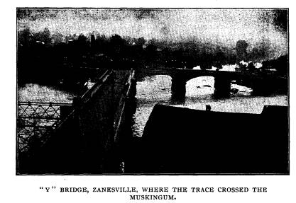
McIntire established a ferry where the
"Y" bridge now
stands. He made a mistake in exacting a
tariff from immi-
grants and fishermen, who passed along
the stream, but upon
discovering his error he abandoned it.
But on January 23, 1802,
2 Lewis Cass, referring to this incident
in his book, says: "At Zanes-
ville the party found the comfortable
cabin of Mr. McIntire, whose name
has been preserved in the King's memory
and whose home was a favorite
place of rest and refreshment for all
travelers, who at this early period
were compelled to traverse that part of
the country. And if these pages
should chance to meet the eyes of any of
those, who, like the writer, have
passed many a pleasant hour under the
roof of this uneducated but truly
worthy and respectable man, he trusts
they will unite in this tribute to
his memory." - Wiseman's Pioneers
of Fairfield County.
Zane's Trace. 327
the Second Territorial Legislature
authorized Jonathan Zane, et
al., to erect a toll bridge where the
"Y" bridge now is.
In the first Constitutional Convention,
he was a delegate and
signed the organic laws for Ohio's
statehood. From this time
till his death he was the leading
citizen of Zanesville. As a
public benefactor that city has yet just
cause not to forget.
In the will of John McIntire, dated
March 18, 1815, pro-
vision is made that in the event of his
daughter leaving no heirs,
that his estate after the death of his
wife shall be "for the use
and support of a poor school which they
are to establish in the
town of Zanesville for the use of poor
children in said town."
In 1855 the public schools of Zanesville
had become so well
established that there were no longer
poor children, education-
ally speaking, in it. The present John
McIntire Children's
Home is now the beneficiary of the will.
The estate, which has
been judiciously administered, was worth
on May 15, 1902,
$282,347.25.
1The Zanesville Athaeneum, the only
public library in that
city, receives a large share of its
revenue from the McIntire estate.
The John McIntire Sewing School is also
supported by the
same means.
The John McIntire Children's Home is the
best monument
its founder could have. Situated on a
beautiful hill overlooking
the city, which he founded, this refuge
for poor children is a
living testimony of the beneficence of
the man who sleeps be-
neath its shadow.
In the making of Ohio, John McIntire
occupied no mediocre
position and we doubt if any other
pioneer in the state has suc-
ceeded in continuing his good offices so
long after his de-
parture. Much of the McIntire furniture
is in the Children's
Home. The old sideboard and chest of
drawers of antique pat-
tern, are of especial interest. A
sampler made by the daughter,
Amelia McIntire, and showing her
handiwork, is also there. The
pictures of John McIntire and wife hang
on the walls of the re-
ception room.
1 On June 1, 1904, the Zanesville
Athaeneum was transferred to the
Board of Education.
|
328 Ohio Arch. and Hist. Society Publications.
John and Noah Zane laid out Lancaster in 1799 and com- menced the sale of lots. They had the power of attorney and made the deeds. Ebenezer Zane himself was never in Lan- caster. Before Lancaster was laid out, travelers who passed along Zane's Trace called the spot "the place where they crossed the Hockhocking near the Standing Stone." In 1799 a postoffice was established. The mail was car- ried once a week each way. Samuel Coates, Sr., was postmaster. General Sanderson, the Fairfield County historian, then a lad, |
|
|
|
was post-boy between Chillicothe and Zanesville. There were not half a dozen cabins on the whole route. Maple street, Lancaster, is on the east line of the original Zane section. The north line is now the alley just north of the German Lutheran Church. The south line is now a part of the south line of the Mithoff farm. The west line starts at a point in the south line near the sugar-grove on the Mithoff farm, returning thence north.
"Article of agreement made and entered into by and between Eben- ezer Zane, of Ohio County, Va., and the purchasers of lots in the town |
Zane's Trace. 329
of Lancaster, county of Fairfield,
territory northwest of the Ohio River,
now for sale in lots, on the east side
of the Hockhocking River, by Eben-
ezer Zane.
Section 1. The lots to be numbered in
squares beginning with the
northwest corner of the town, and then
alternating from north to south,
and from south to north, agreeable to
the general draft of the town.
Section 2. One-fourth of the purchase
money will be required two
weeks from the date of this article. The
residue of three-fourths will be
required on or before 14th of November,
1802. To be approved by secured
notes bearing lawful interest from the
14th day of November, 1800.
Section 3. Square No. 16, including five
lots in the southeast cor-
ner of the town, was thereafter to be
held in trust, for the use of a grave-
yard, erection of a school house, a
house of worship, and such other build-
ings as may be found necessary. All of
which are to be under the direc-
tion of the trustees for the time being.
Also four lots at the intersection
of the two main streets running east and
west and north and south, known
by appellation of the Center Square, are
given for the purpose of erecting
public buildings not heretofore
specified.
Section 4. Possession will be given
immediately to purchasers com-
plying with Section 2 of this Article.
When fully complied with the said
Ebenezer Zane and his heirs, bind
themselves to make a deed to the pur-
chasers, their heirs and assigns. If the
terms be not fully complied with
the lots shall be considered forfeited
and returned again to the original
holder.
Section 5. For the convenience of the
town, one-fourth part of an
acre, lying west of lot No. 2 in the
square No. 3, including two springs,
will be, and are hereby given for the
use of its inhabitants, as the trus-
tees of the town may think proper.
Section 6. In consideration of the
advantages that arise from the
early settlements of mechanics in the
town, and the encouragement of those
who may first settle, lot No. 3 in 20th
square; lot No. 6 in 15th square;
lot No. 6 in 12th square, will be given
to the first blacksmith, the first
carpenter and the first tanner, all of
whom are to settle and continue in
the town pursuing their respective
trades for the term of four years, at
which time the aforesaid Zane binds
himself to make them a deed.
In testimony of all and singular, the
premises, the said Ebenezer
Zane by his attorneys, Noah and John
Zane, hath hereunto set his hand
and affixed his seal, this 14th day of
November, A. D. 1800.
EBENEZER ZANE.
The Chillicothe tract was located on the
east side of the
river, because the lands on the west of
the Scioto had already
been appropriated in the Virginia
Military Grant. Ebenezer Zane
deeded this tract to Humphrey
Fullerton In 1839, when Caleb
|
330 Ohio Arch. and Hist. Society Publications.
Atwater wrote the first history of Ohio, Fullerton's widow was yet in possession of the land. A traveler over Zane's Trace leaves us this description of it: "We started back to Pennsylvania on horseback, as there was no getting up the river that day. * * * There was one house (Treiber's) at Lick Branch five miles from where West Union now is. * * * The next house was where Sinking Springs or Middletown now is. The next was at Chillicothe, which was just then commenced. We encamped one night on Massie's |
|
|
|
Run, say two or three miles from Paint creek, where the Trace crossed the stream. From Chillicothe to Lancaster, the Trace then went through Pickaway Plains. * * * There was a cabin three or four miles below the plains and another at their eastern edge, and one or two more between that and Lancaster. * * * Here we stayed the third night. From Lancaster we went the next day to Zanesville, passing several small beginnings. I recol- lect no improvement between Zanesville and Wheeling except one |
|
Zane's Trace. 331 at the mouth of Indian Wheeling Creek opposite Wheeling." -American Pioneer. This in brief is the history of the famous "Zane's Trace." The rough trail with its blazed trees has passed away. Only here and there can we with certainty locate its ancient course. But it was a factor in the making and the "winning of the west," and every city and town along its narrow route is a product of this first Ohio roadway. But back of it all stands the heroic pioneer and "Hero of the Forest," Ebenezer Zane. |
|
|