Ohio History Journal
THE

|
|
ORIGIN AND LOCATION OF THE FIRELANDS
OF THE WESTERN RESERVE
By
HELEN M. CARPENTER
Copyrighted, 1935, by Helen M. Carpenter
(163) |
TABLE OF CONTENTS
PAGE
British Invasions of Connecticut during the Revolutionary
War
.............................................. 65
Appraisement of Losses and Granting of Relief .......... 69
Title of Connecticut to Lands Granted .................. 174
Location of Claimants on Lands Granted--the Connecticut
Company ......................................... 175
Location of Claimants on Lands Granted--the Ohio Company 181
Incorporation .................................. 181
Organization .................................. 182
Operations .................................... 183
Extinction of the Indian Title .............. 183
Surveys ................................. 187
Partition of the
Lands .................... 192
Financial Operations ...................... 193
Dissolution
..................................... 194
Political Organization ................................. 195
Bibliography
........................................ 196
Maps--
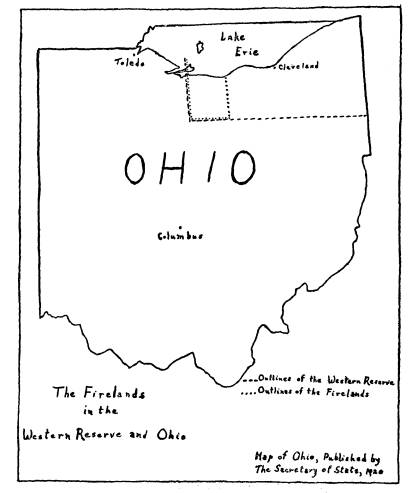
The Firelands in the Western Reserve and Ohio.... 176
Reproduction of the Amos Doolittle Map of Almon
Ruggles' Survey of the Firelands....... FRONTISPIECE
(164)
THE ORIGIN AND LOCATION OF THE FIRELANDS
OF
THE WESTERN RESERVE
British Invasions of Connecticut
during the Revolutionary War.
Bunker Hill, Trenton, King's Mountain,
Yorktown--none of
the historic encounters of the
Revolutionary War occurred on the
soil of Connecticut. Yet its inhabitants
suffered that destruction
of life and property which attends any
military campaign. Con-
necticut was the scene of a different
kind of warfare. It was the
victim of terrorization! To harry,
ravage and burn became the
British policy after 1778 when the
campaigns for control of the
Hudson had miscarried. That submission
in the North which
open conflict had failed to bring,
England hoped to accomplish
by intimidation. The proximity of
coastal towns in Connecticut
to the English stronghold in New York
probably accounted for
the concentration of raids there. But
little could England realize
that the invasion of Connecticut towns
would serve to push west-
ward the frontiers of the very colonies
it was struggling to stifle.
It could not anticipate that the torches
of British soldiers firing
the dwellings of Connecticut patriots
were to light the hearth
fires of pioneer homes in north central
Ohio. Rather this guerilla
warfare, requiring comparatively few men
and a short time seri-
ously to hamper rebel effectiveness,
seemed to accomplish well
the ends of the mother country. An
advance by water under
cover of night, a surprise attack upon
the town, a day of plun-
dering, pillage, and burning, a hasty
retreat before the colonial
defense marked the execution of another
British raid.
Although these incursions terrorized
seaboard inhabitants of
Connecticut from time to time throughout
the War, four major
raids were perpetrated over as many
years. To Danbury, since
1776 a depository for military stores by
order of the commis-
(165)
166
OHIO ARCHEOLOGICAL AND HISTORICAL QUARTERLY
sioners of the Continental Army,1 came
word on the morning of
April 26, 1777, that the British were
coming. The terrified cit-
izens, protected by only one hundred
fifty militia and soldiers,
fled and left their village to the mercy
of the two thousand British
who marched in during the afternoon
under command of Major-
General William Tryon.2 From
two A.
M. until daylight the
skies glowed as flames consumed military
supplies, homes, shops,
and even the Congregational Meeting
House.3 Returning in-
habitants found that whitewashed crosses
had saved the property
of Tory sympathizers from the conflagration.4 The
trail of
destruction lay through the town of
Ridgefield, near where the
colonials under Generals Benedict
Arnold, Gold Sellick Silliman,
and David Wooster attempted to stop the
retreating British.5
Connecticut was spared for two years
from depredations of the
enemy until the importance of the salt
works in the vicinity of
Greenwich as a source of supply to the
Continental Army made
that village a prey to English soldiers
on February 26, 1779. The
invaders, ravaging as they went, soon
routed General Isaac Put-
nam and his inadequate forces. Tradition
ascribes the escape of
this general to the descent of a
perilous incline where his pursuers
dared not follow.6 Martial
violence continued with an expedition
against New Haven, Fairfield, and
Norwalk early in July of 1779.
On the night of July 4, a fleet bearing
three thousand British
and Hessian soldiers moved into the
harbor of New Haven under
the command of Sir George Collier.7 From
the ship Camilla
1 John Warner Barber, Connecticut
Historical Collections, Containing a General
Collection of Interesting Facts, Traditions,
Biographical Sketches, Anecdotes, etc.,
Relating to the History and
Antiquities of Every Town in Connecticut with Geograph-
ical Descriptions (New Haven, 1838), 364-65.
2 Colonial governor of New York commissioned by Lord William Howe for the
expedition. Forrest Morgan, Connecticut as a Colony
and as a State or One of the
Original Thirteen (Hartford, 1904), II, 95-96; Charles W. Burpee,
"Connecticut in
the Wars," in Norris Galpin Osborn
(ed.), History of Connecticut in Monographic
Form (New York, 1925), V, 39-40.
3 "Sir William Howe's Return of
Stores Destroyed in Danbury," quoted in
Morgan, Connecticut as Colony and
State, II, 101; "Robbin's Century Sermon," quoted
in Barber, Connecticut Historical Collections, 365.
4 Morgan, Connecticut as Colony and State, II, 97-98.
5 Memorial from the Selectmen of
Ridgefield to the General Assembly of Con-
necticut, in Public Records of the
State of Connecticut with the Journal of the
Council of Safety, 1776-1781; compiled by Charles J. Hoadly (Hartford, 1894), I, 298;
Morgan, Connecticut as Colony and
State, II, 98.
6 Ibid, II,
137-38.
7 Connecticut Journal (New Haven), July 7, 1779; quoted in Charles Hervey
Townshend, The British Invasions of New Haven,
Connecticut (New Haven, 1879), 25.
FIRELANDS OF THE WESTERN
RESERVE 167
Tryon and Collier issued an
"Address to the Inhabitants of Con-
necticut," observing that
the ungenerous and wanton insurrection
against the sovereignty of Great
Britain, into which this colony has been
deluded, by the artifices of design-
ing men, for private purposes, might
well, justify in you every fear which
conscious guilt could form, respecting
the intentions of the present arma-
ment. ... The existence of a single
habitation on your defenceless coast
ought to be a subject of constant
reproof to your ingratitude.
And they warned that lenity could not be
expected hence-
forth unless "you lie so much in
our power, afford that most
striking monument of our mercy and . . .
set the first example
of returning to allegiance."
Immunity of person and property to all
those who remained
peaceful was promised in the impending
raid.8 Not waiting for
the promulgation of the address, Tryon
and General George Garth
invaded East and West Haven during the
early morning hours of
July 5. Colonial defense hastily
organized along the way availed
little. In spite of the pledge of
immunity, by noon all citizens
of New Haven were at the mercy of
indiscriminating marauders.
The destruction by fire of stores along
the wharf and of eight
houses in East Haven9 was
slight in comparison with that which
occurred in Fairfield, to which Tryon
turned on July 7, 1779.
Courthouse, jail, schoolhouses,
churches, homes--everything lay
in ashes when the troops retreated on
July 8 leaving behind again
the proclamation of promised immunity.10
The ruffianism of the
soldiers, gaining momentum with
increasing depredations, vented
itself on Norwalk, July 11, 1779, razing
the entire town in the
face of colonial defense better
organized than in either New
Haven or Fairfield.11
Another two years passed in apparent
serenity. Again came
the alarm of a British attack. This time
to the fright of the
patriots was added the sorrow of
treason. The commander was
not Tryon but Arnold, a native son of
Connecticut, born fourteen
8 Tryon-Collier Proclamation, in Connecticut
Journal (New Haven), July 7,
1779; quoted in Barber, Connecticut
Historical Collections, 171.
9 Ibid., 168.
10 Morgan, Connecticut as Colony and State, II, 144; William Tryon
to Sir
Henry Clinton, July 20, 1779, in Military
America, British Archives, quoted in Town-
shend, British Invasion of New Haven,
35.
11 Morgan, Connecticut as
Colony and State, II, 144-45; Burpee, "Connecticut
in the Wars," in Osborn, History of Connecticut
in Monographic Form, V, 55.
168
OHIO ARCHAEOLOGICAL AND HISTORICAL QUARTERLY
miles from the New London he gave the
orders to raze.12 The
sinister part of Arnold in the
Revolution forms a curious thread
in the story of the British invasions of
Connecticut. In the Dan-
bury raid he resisted the British so
valiantly that Congress voted
him a horse with caparison and accorded
him the promotion to
major general but not with relative
rank. This reservation is
thought to be one of the alleged slights
contributing to his trea-
sonable conduct.13 In early
September of 1781 there were col-
lected in the port of New London
valuable quantities of merchan-
dise from the West Indies and Europe.
Into her harbor also had
come as prize of war the Hannah, a
rich merchant ship, taken en
route from London to New York by Captain
Dudley Saltonstall.
Both factors occasioned the descent upon
the town, September 6,
1781.14 At dawn the discovery of the
British fleet lying in the
harbor produced a bedlam as excited
citizens rushed to place their
families beyond danger, to hide their
valuables, and to defend the
town. Colonel William Ledyard, officer
in command, distributed
men and munitions as well as
circumstances permitted. But what
could a few poorly organized colonials
do against a superior force
commanded by one familiar with the
vicinity since childhood and
who was receiving counsel for the attack
from Tory friends within
New London!15 Frustration met the
citizenry at every turn.
When two cannon shots gave the distress
call, a British gun added
a third turning the signal into one of
victory.16 The local code of
two cannon balls for help and three for
exultation had been made
known to the enemy. Fort Trumbull, the
defense of the town,
stopped the invaders but little as the
two divisions entered at
opposite ends. Already in disarray from
the flight of the in-
habitants, the village presented a scene
of wild confusion as flames
roared down the streets from market
wharf to battery, from
courthouse to jail, from dwelling house
to Episcopal Church.
Smoke enveloped the whole. Gutters
flowed with rum and Irish
12 Frances Manwaring Caulkins, History
of New London, Connecticut, 1612-1852
(New London, Connecticut, 1852), 554.
13 Burpee, "Connecticut in the Wars," in Osborn, History of
Connecticut in
Monographic Form, V, 41.
14 Caulkins, History of New
London, 545.
15 Ibid., 554.
16 Ibid., 546-47.
FIRELANDS OF THE WESTERN RESERVE 169
butter melted by the fire. Coffee and
sugar from broken barrels
strewed the streets. The burning Hannah
broke from its moor-
ings to drift down the river and sink
near Winthrop's Neck.17
From time to time Arnold was seen on a
height viewing the
devastation and reconnoitering for the
greater disaster now be-
ginning in Groton. To the destruction of
property was added
the slaughter of human life in a
massacre as brutal as any of the
Revolution. An attempt to prevent the
escape of the shipping
up the river brought the attack on Fort
Griswold at Groton.18
The demand of immediate surrender met a
sturdy refusal from
the valiant but inadequate defenses of
the fort. Forty minutes
of desperate fighting ensued amid
discharges of grape-shot, volleys
of bullets, avalanches of missiles, and
bodies of British and Con-
tinentals writhing or prostrate where
they fell. The struggle con-
tinued in the west bastion when the fort
had surrendered, so great
was the confusion. Ledyard perished by
his own sword at the
hands of the British officer who had
accepted it in surrender.
Plundering of the dead and wounded
followed the cessation of
hostilities. Preparatory to blowing up
the fort, the British at-
tempted to remove the helpless
colonials. A wagon heavy with
the bleeding bodies of some was
permitted to lurch unrestrained
down a steep descent of one hundred rods
to the river. The
impact as the wagon struck a tree and
recoiled caused several
of the groaning bodies to be hurled
out.l9 Igniting the barracks
and laying a trail of powder to the
magazine, the British sailed
down the river late in the evening,
leaving death and destruction
in their wake.
And thus ended the British raids into
Connecticut, the last
one, more ghastly than the rest,
perpetrated by one of her own.
Appraisement of Losses and Granting
of Relief.
As the last British soldier disappeared
in retreat, citizens of
the nine20 suffering towns
were faced with problems sufficient to
17 Ibid., 553.
18 Ibid., 557.
19 Ibid., 565.
20 Danbury, Ridgefield, Greenwich, New
Haven, East Haven, Fairfield, Norwalk,
New London, and Groton.
170 OHIO ARCHAEOLOGICAL AND
HISTORICAL QUARTERLY
test the spirit of the most loyal.
Provision of food, clothing, and
shelter, never an easy task, became a
problem of increased diffi-
culty. Fields with oncoming crops lay in
waste. Barns storing
the harvest of other years were
destroyed. Flames had consumed
necessities in the stores or marauders
had played such havoc with
the barrels and bags that the
commodities were no longer edible.
Personal property which had survived the
ravages of firebrand
and pillager frequently was not worth
salvaging. So extensive
had been the conflagration that rented
buildings were at a pre-
mium. Scarcity of materials hindered
those who possessed the
means to rebuild their homes.21 To
the problems of living were
added the burdens of government.
Taxes--town, state, society,
with additional ones for the
reconstruction of public buildings--
continued to be levied. Upon such towns,
also, the Continental
Army depended for recruits and the
expenses of maintenance.22
In their distress the sufferers turned
to the General Assem-
bly. Throughout the ten years between
the first incursion and
1787, numerous memorials were sent from
the individual towns
praying for relief. In a typical one
"Dated at Norwalk the 8th
Day of December A. D. 1780,"
thirty-eight subscribers represent
to the Assembly
that in the Month of July in the Year
1779 your Honble Memorialists
together with many others Inhabitants of
sd Norwalk were burnt out of
House and Home and Striped and plundered
by the Enemy of almost all
our Household Furniture and that by
means of having our Barns Destroyed
by Fire the greater part of our wheat
Harvest and English Hay was then
Consumed to a very great amount and to
our very great Distrefs and im-
poverishment . . . that altho many of
the Sufferers have the Summer
past got themselves Houses yet they out
of necefsity will be oblidged to
live in them through this Winter without
being finished for want of many
materials and money to purchase others
and that by means of the high
prices of Materials for Buildings and
the very great Demand for Labor
your Honble Memorialists are very much
involved and it appears to many
of them as if it was impofsible to ever
regain their Lofs ... we would
therefore beseech your Honrs to take our
unhappy and Distrefsed Situation
and Circumstances into your wise
Consideration and abate the whole of
our State Taxes that are or may be laid
upon the List 1779 and also upon
the List 1780 or in such other way grant
us such Relief in the premifes as
21 Memorial of Norwalk and Fairfield to
the General Assembly Praying for
Building Supplies, March 26, 1780, in Hoadly, State
Records, II, 511.
22 Petition
of John Lockwood and Others of Norwalk to the General Assembly,
December, 1780, in Royal R. Hinman
(comp.), A Historical Collection from Official
Records, Files, etc., of the Part
Sustained by Connecticut during the War of the
Revolution (Hartford,
1842), Appendix, p. 625.
FIRELANDS OF THE WESTERN RESERVE 171
your Honrs in your great wisdom shall
judge Just and Equitable and we
as in Duty bound shall Ever pray.23
In response to these entreaties the
Assembly from time to
time appointed committees instructed to
retire to the respective
towns, estimate the amount of losses
sustained, and provide for
an abatement of taxes over a given
period.24 Sympathetic
as the
memorials and committee reports alike
show the General Assem-
bly to have been, the financial
condition of the state did not per-
mit the granting of relief in any
adequate form such as direct
payment from the treasury or the levying
of a general tax for
this purpose.25
Since the towns had been invaded at different
times, it is not
surprising that they pressed their
earliest claims separately. But
by 1787, with a large aggregate of
losses uncompensated, that
cooperation which a common trouble
brings became evident
among the towns. In a memorial dated at
Hartford, May 21,
1787, the sufferers united in
petitioning for "such Relief as the
Nature of the Case & Justice
Require," and to which "they humbly
conceive they have a righteous and
constitutional claim." Com-
plaint is made of two similar memorials
previously preferred
which received no answer. The document
was signed by Daniel
Taylor in behalf of the sufferers of
Danbury; Thomas Fitch of
Norwalk; Jonathan Sturges of Fairfield;
John Mead of Green-
wich; Ebenezer Ledyard of Groton; John
Deshon of New Lon-
don; Charles Chauncey of Ridgefield; and
Andrew Ward and
Daniel Leete of Guilford.26 A
special committee consisting of
Colonel Jeremiah Wadsworth, Major
Charles Phelps, Major Wil-
liam Hart, and Colonel Charles Burral
from the Lower House,
23 Connecticut Archives (in Connecticut
State Library), Revolutionary War, 1st
series, XIX, Doc. 77a-d.
24 Examples of memorials from the
individual towns and committee reports show-
ing losses and abatements granted are ibid:
Ridgefield, VII, 28; VIII, 391; Green-
wich, XIX, 80, 81; XVIII, 368, 370; New
Haven, XV, 234, 270; XXVII, 81; Fairfield,
XV, 249; XIX, 71a 70-72, 73a-d, 75a-d;
Norwalk, XIX, 76, 78; New London, XXII,
371-373; XXVII, 79, 80, 331; Groton,
XXII, 304, XXVI, 292, 293; XXVII, 79, 80. Typical
manuscripts are available in print in
Hoadly, State Records: Danbury, I, 214, 217, 296,
373, 428; Ridgefield, I, 298; Greenwich,
II, 328, 357, 432, 465; New Haven, II, 355, 373,
387, 426, 470, 485; Fairfield, II, 353,
373, 387, 432, 492, 510, 553; Norwalk, II, 59, 136, 360,
364, 371, 373, 425, 560; New London and
Groton, III, 524, 546, 548, 550. A few are also
available in Hinman, Historical
Collections, Appendix, 612-18, 624.
25 Jonathan H. Trumbull, "Abstract
of the Record History of the Fire Lands
Grant, from the Records of the State of
Connecticut, October 7, 1862," in Firelands
Pioneer (Norwalk,
Ohio, 1858-), old Series, IV (June, 1863), 95.
26 Connecticut Archives, Revolutionary
War, 1st series, XXXVI, 351a.
172 OHIO
ARCHAEOLOGICAL AND HISTORICAL QUARTERLY
and Andrew Adams from the Upper House
took the memorial
with its accompanying exhibits and
documents for consideration.27
Upon report of that body to the May
session
that it hath been usual for other humane
civilized nations, particularly the
Dutch, to extend more or lefs Relief, to
their suffering Subjects, in similar
cases, upon the return of Peace. That
therefore it is the opinion of your
Comtee, that Equity, Justice, and good
policy require, that some further
Consideration and allowance be made to
the mem1ts
but that a full investigation
necessitated longer time, the General
Assembly referred the matter to the
October session.28 At that
time the committee deplored the lack of
sufficient documents on
the losses sustained and abatements
granted which prevented cor-
rect statement of the claims
unremunerated but gave its opinion
that the Houfes building [sic] necesfary
Houfehold furniture in thofe Fron-
tier Towns mentioned in the memorial
burnt and deftroyed by the Enemy
during the Late War ought to be by this
State paid for at their Juft Value.
That the only means in the power of this
State at prefent to pay the
same is in the Weftern Lands owned by
this State referved their--late
cefsion to Congress.29
The Lower House approved the conclusions
of the committee
immediately, but consideration in the
Upper House was continued
to the May session of 1788. The report
of a conference commit-
tee composed of Phelps and Wadsworth
from the Lower House
and Joseph Spencer of the Upper House
was subsequently re-
jected by the Upper House.30 Ceasing to claim the attention of
the Assembly after the session of
October, 1788, the memorial
disappeared without securing the
expected relief.
A last memorial was preferred by
Thaddeus Betts of Nor-
walk and Thaddeus Burr and others of
Fairfield to the General
Assembly in session December, 1790,
showing that in the month of July in the
Year 1779 the Buildings and other
Property of the Memorialists were burnt
& destroyed by the Subjects of
the King of Great Britain then being
Enemies at open War with the United
States, that by means thereof the
Memorialists have suffered great Diffi-
culties and distrefses, and many of them
are reduced to Indigent Circum-
stances.31
The General Assembly constituted John
Treadwell, Asher
27 Ibid., XXXVI,
116.
28 Ibid., XXXVI,
15.
29 Ibid., XXXVI, 117a.
30 Ibid.
31 Hoadly, State Records, IV,
23.
FIRELANDS OF THE WESTERN RESERVE 173
Miller, and Captain John Chenward a committee to ascertain from
documents of earlier committee investigations, the amount of
losses of those suffering from the British incursions and the ad-
vancements already made by the state.32 When "through
some in-
tervening and unavoidable Circumstances" the committee had not
completed its business by the session of May, 1791, the Assembly
reappointed it to make report in October of 1791.33 Upon
favor-
able report of the above committee the General Assembly of Con-
necticut on May 10, 1792,
released and quit-claimed to the Sufferers hereafter named, or their
legal
representatives, where they are dead, and to their heirs and assigns
forever,
five hundred thousand acres of the lands belonging to this state, lying
west of
the state of Pennsylvania, and bounding northerly on the shore of Lake
Erie,
beginning at the west line of said lands, and extending eastward to a
line
running northerly and southerly, parallel to the east line of said tract
of
land belonging to this state, and extending the whole width of said
lands,
and easterly so far, as to make said quantity of five hundred thousand
acres of land.34
At the end is appended the list of sufferers with the uncom-
pensated losses classified by towns. The method of entry in the
resolution makes any accurate statement of the number of persons
remunerated impossible.35 The nine towns received
compensation
in the grant amounting to one hundred seventy-five thousand, two
hundred forty-four pounds, four shillings, six pence for one thou-
sand, eight hundred sixty-six losses. By towns the losses were
as follows:36
Town
Losses ?? s d
Danbury .............. 186 8,238 18 10
Ridgefield ...............
65 1,736 1 10
Greenwich ............... 279 26,333 16 4 1/4
New Haven and East Haven 410 17,079 3 10 1/4
Fairfield ................
269 33,455 2 9
Norwalk ................ 289 26,062 15 3
1/2
32 Ibid., IV, 23.
33 Ibid., IV, 26.
34 Ibid., IV, 66
35 Some entries are a name "and sons," "and others,"
or "and Co."
36 Computed from the list in
the copy of the Connecticut Resolution contained in
the
Record Book of the Company, Incorporated by the State of Ohio, by the Name
of "The proprietors of the half million acres of land, lying south
of Lake Erie, called
Sufferers Land," 1804-1811, Record Sufferers' Lands No. 1, (in
Huron County, Ohio,
Office of Recorder), 21-49.
174 OHIO ARCHAEOLOGICAL AND HISTORICAL QUARTERLY
Town Losses ?? s d
New
London ............ 275 54,598 9 1
1/2
Groton
.................. 93 7,739 15 6
Inequalities
in coins and money existing after the Revolu-
tion,
the period during which the losses were being estimated by
legislative
committees, do not permit a reliable statement of the
value
of the losses in dollars.37 A further provision of the resolu-
tion
required the grantees to survey the tract at their own ex-
pense
and to submit a plan for such to the General Assembly in
order
to assure a satisfactory settlement of the east line of the
grant.
In a resolution of May, 1795, the Assembly released the
grantees
from this obligation.38
Title
of Connecticut to Lands Granted.
From
whence came the title of Connecticut to the land south
of
Lake Erie now released? When Charles II granted a charter
to
Connecticut in 1662, the boundaries of the colony were defined
as
all
that parte of our Dominions in Newe England in America bounded on
the
Eaft by Norrogancett Riuer comonly called Norrogancett Bay where
the
said Riuer falleth into the Sea, and on the North by the Lyne of the
Maffachufetts
Plantation and on the South by the Sea, and in longitude
as
the Lyne of the Maffachufetts Colony runinge from Eaft to Weft that
is to
say, from the said Narrogancett Bay on the Eaft to the South Sea
on
the Weft parte with the Iflands thervnto adjoyneinge.39
This
was one of the famous sea to sea grants of the English
crown,
and by it Connecticut gained a limitless claim westward.
By
the Revolutionary period the claims of some states to
western
lands occasioned sufficient jealousy on the part of the
states
of New Hampshire, Rhode Island, New Jersey, Delaware,
and
Maryland with fixed boundaries, as to delay ratification of
the
Articles of Confederation. Maryland was particularly ad-
amant.
Congress called upon the states to cede whatever titles
to
western lands were claimed. When New York offered to give
37
For discussion of the currency at this time see John Bach McMaster, A His-
tory
of the People of the United States from the Revolution to the Civil War (New
York,
1883), I, 189-94.
38
Hoadly, State Records, V, 21.
39
The extant copy of the two original texts of the Charter.
FIRELANDS OF THE WESTERN RESERVE 175
up its lands in 1781, Maryland ratified
the Articles.40 On Sep-
tember 11, 1786, Connecticut fulfilled
the moral obligation re-
maining, when it conveyed to the United
States through Samuel
Johnson and Sturges, delegates in
Congress,
all the Right, title, interest,
jurisdiction and claim of the State of Con-
necticut to certain western lands
beginning at the completion of the forty
first degree of north latitude one
hundred and twenty miles west of the
western boundary line of the
Commonwealth of Pennsylvania as now
claimed by said Commonwealth, and from
thence by a line drawn north
parallel to and one hundred and twenty
miles west of the said west line of
Pensylvania, and to continue north until
it comes to forty two degrees
and two minutes north latitude.41
The tract reserved by Connecticut in
what is now north-
eastern Ohio became known as the
Connecticut Western Reserve
and more generally as the Western
Reserve. It was the western
part of this Reserve to the extent of
five hundred thousand acres
which Connecticut released to the fire
sufferers in 1792. Hence
comes the name, the Firelands of the
Western Reserve.
Although Congress by resolution on
September 14, 1786, ac-
cepted the deed of cession,42 the
United States government did not
recognize the title of Connecticut to
the Western Reserve.43 The
difficulty was compromised in 1800 when
the United States con-
veyed the right to the soil of the
Western Reserve to the state of
Connecticut for the benefit of those
holding titles in the tract. In
return Connecticut released all
political jurisdiction over the
area.44
Location of Claimants on Lands
Granted
--The Connecticut Company.
In an account of the location of the
Firelands some mention
should be made of the company
incorporated under Connecticut
40 Edward Channing, A
History of the United States (New York, 1924), III,
453-56.
41 Deed of Cession certified from the
records of the Department of State.
42 Act of Acceptance certified from the
records of the Department of State.
43 J. W. Powell, "Schedule of
Treaties and Acts of Congress Authorizing Allot-
ments of Land in Severalty," U. S.
Bureau of American Ethnology Annual Reports
(Washington, 1881-), XVIII (1896-1897),
part 2, 666-67. See also Treaty of Green-
ville, Article 3, in A
Compilation of Laws, Treaties, Resolutions, and Ordinances, of
the General and State Government, Which Relate to
Lands in the State of Ohio;
Including the Laws Adopted by the Governor and
Judges; the Laws of the Territorial
Legislature; and the Laws of This State to the Year
1815-1816. [Referred to hereafter
as Land Laws for Ohio.] (Columbus, Ohio, 1825),
Appendix, 479-80.
44 May 30, 1800, Laws of
the United States (Philadelphia, 1815), I, 405, quoted
in ibid., 80-81.
|
176 OHIO ARCHAEOLOGICAL AND HISTORICAL QUARTERLY |
|
|
|
law for that purpose. Since the sources on the operation of this corporation are fragmentary, it is impossible to state how impor- tant a part it played. Apparently its existence was of significance only as the tax which it levied caused some sufferers to forfeit their interests in the Firelands at the outset. That the Firelands grant of 1792 did not end the difficulties |
FIRELANDS OF THE WESTERN RESERVE 177
facing the sufferers is shown by two
memorials, alike in text but
preferred by different petitioners, to
the General Assembly in the
May session of 1795. From a notation on
the back of each by
"W. Bifsell Clk," both were
admitted to the House of Represen-
tatives on June 3, 1795. One was signed
by Comfort Hoyt,
Junior, and eleven other men or the
representatives of their estates.
Thirty-five sufferers or the
administrators of the estates of such
affixed their names to the other. In
both the subscribers set forth
that they deem it necefsary to take
meafures for Afcertaining the Boun-
daries and Extent of said Grant and for
extinguishing the native right,
but on Account of the great numbers and
the scattered Situation of the
Grantees, and that many are Minors and
Feme Coverts and because of the
great diverfty of Opinion
necefsarily--attending so large a number, and
with many on Account of the Smallnefs of
their Interest, a total neglect
and disregard therof your Memorialifts
find unfurmountable difficulties in
the way of Just Meafures, and they would
fuggest to your honors that if
the Proprietors of said Grant were
Incorporated, with proper powers to
manage and direct the affairs of said property
it would enable them so
to manage and dispofe thereof, as to
render it profitable and fubfervient
to the benevolent purpofes of the
Grantors and without such Interpofition
of your honors they dispair of ever
deriving any advantage therefrom.45
To this reasonable appeal the Assembly
responded in the Oc-
tober session of 1796 with an act
incorporating the grantees under
the name of "The Proprietors of the
Half Million Acres of Land
lying south of Lake Erie."46
The statute provided for annual meetings
of the proprietors
in the respective towns on the last
Tuesday of December to elect
local officers consisting of a chairman,
a clerk, and a collector and
agents to represent the proprietors in
the general meeting. The
amount of allowed losses determined the
number of votes con-
trolled by a single proprietor and the
number of agents permitted
to a town. In the agents was vested
power to extinguish the In-
dian title, to survey the lands for
location, and to partition the
same into townships. To carry on the
foregoing, the act empow-
ered the agents to levy taxes according
to the amount of losses,
with authority to sell the rights in
case of default. Another sec-
tion made the act obligatory only upon
those grantees who ac-
cepted its provisions by registering
with the clerk of the propri-
45 Connecticut Archives (in Connecticut
State Library), not catalogued.
46 Acts and Laws of the State of Connecticut in
America, known as Connecti-
cut Revised Statutes, 1796. Public Acts, 1796-1808 (Hartford, 1805), 451.
178
OHIO ARCHAEOLOGICAL AND HISTORICAL
QUARTERLY
etors in the respective towns. When the
above provision was re-
pealed by amendment on May 23, 1797, all
grantees under the
Act of 1792 automatically became
incorporated. A further pro-
vision of the amendment gave increased
protection to minors,
married women, the insane, and those
outside the United States
against the sale of rights for the
non-payment of taxes.47
Records of the company thus created, if
extant, are unavail-
able. Occasional newspaper notices, some
old tax deeds, and a
single entry in the accounts of the
company which succeeded it
comprise the only sources upon the
activities of "The Proprietors
of the Half Million Acres of Land lying
south of Lake Erie" in-
corporated under the laws of
Connecticut. More information is
available upon the operation of the
company in New Haven than
in the other towns. The combination of
two factors there may
explain this. At that time New Haven as
well as Hartford served
as a capitol of Connecticut and was so
recognized by the Act of
Incorporation directing the agents to
hold meetings in either New
Haven or Hartford. Not adequate in
itself but of importance in
view of the above, was the regular
publication of a weekly news-
paper in New Haven called the Connecticut
Journal.48 Activities
of the company in New Haven were no
doubt typical of those in
the other suffering towns.
For six weeks previous, grantees in New
Haven and East
Haven were warned of the meeting of the
proprietors to be held
at the state house in New Haven on the
morning of December
27, 1796, at nine o'clock.49 When the proprietors assembled they
chose John P. Austin, collector; Abraham
Bishop, clerk; and
Isaac Mills and Bishop, agents.50 The
first meeting of the agents
47 An Act in Addition to, and Alteration
of an Act, Entitled "An Act for In-
corporating the Proprietors of the Half
Million Acres of Land, lying south of Lake
Erie," ibid., 461. The
original bill of the act is among uncatalogued Connecticut
Archives.
48 Connecticut Gazette, also a weekly, was published in New London. The Act
of Incorporation and a notice appearing
in the Connecticut Gazette, July 26, 1797,
and in the Connecticut Journal, June
28, 1797, July 5, 1797, July 12, 1797, indicate the
publication of a newspaper in Danbury at this time.
Copies are not available in
Hartford or New Haven.
49 Connecticut Journal, November 16, 1796, November 23, 1796,
November 80, 1796,
December 7, 1796, December 14, 1796,
December 21, 1796. Throughout the towns of New
Haven and East Haven were considered as
one. An item in the Connecticut Gazette,
December 21, 1796, gave similar notice
to the proprietors in New London and Groton.
50 Connecticut Journal, January
4, 1797, January 11, 1797, January 18, 1797.
FIRELANDS OF THE WESTERN RESERVE 179
took place on the second Tuesday of
March, 1797, at the state
house in New Haven according to the Act
of Incorporation. To
Bishop went also the office of clerk of
the agents. It was voted
that, upon application of any five
proprietors with aggregate losses
of five hundred pounds, the chairman in
any of the towns should
be required to call a meeting with
authority to transact business
consistent with the incorporation.51
That privilege appears never
to have been used. The same meeting
directed the clerks in the
several towns to certify the amount of
losses entered in their of-
fices to the next general meeting. The
importance of this action
was nullified by the 1797 amendment to
the Act of Incorporation
discussed above.
Of the powers enumerated in the Act of
Incorporation, the
agents apparently exercised but one, the
levying of a tax on the
allowed losses of the proprietors. The
action was taken when
a general meeting of the agents of the
proprietors of the Half Million
Acres of Land, lying fouth of Lake Erie,
holden at Hartford (by ad-
journment), on the 17th of May, 1797,
Voted, That a tax of one cent on
the pound be laid on the proprietors of
faid land, payable by the 15th day
of August next.52
The proprietors could not be expected to
respond immediately
to the payment of a tax levied upon
rights granted by reason of
destitute circumstance. Nor was collection pressed at once.
During the last two weeks of December,
1797, and the first one
of January, 1798, Austin, collector for
New Haven and East
Haven, by public notice urged the
proprietors to call upon him
and pay within twenty days. Those who
failed to comply were
warned of a public sale of their rights.53 Of the four hundred
ten allowed losses in New Haven and East
Haven, the tax had
been paid on only sixty-three by January
18, 1798. On that day
the collector gave notice of a public
sale at the house of Ebenezer
Parmelee, tavernkeeper in New Haven, at
two o'clock in the after-
noon of March 5, 1798, for the purpose
of disposing of sufficient
51 Ibid., March 22, 1797, March 29, 1797, April 5, 1797.
52 Connecticut Gazette, July 12, 1797; Connecticut Journal, June
28, 1797, July 5,
1797, July 12, 1797. Deeds recording the
sale of rights for non-payment of the tax
give August 5 as the day of payment, in
Record of Sufferers' Deeds for New Haven
and East Haven, 1795-1798 (in Huron
County, Ohio, Office of Recorder), Vol. A, 138.
53 Connecticut Journal December 21, 1797, December 28, 1797, January 4, 1798.
180 OHIO ARCHAEOLOGICAL
AND HISTORICAL QUARTERLY
rights of the defaulting proprietors to
pay the tax of one cent on
the pound together with the fees and
costs accruing. The names
of those three hundred forty-seven
grantees still liable were ap-
pended to the notice.54 This public
exposure brought a more
effective response and but seventy-nine
of the rights remained to
be disposed of at the sale.55
Similar procedure to force payment of
the one cent tax was
resorted to in Fairfield. On January 15,
1798, Lothrop Lewis,
collector, conducted the sale of rights
to meet the tax on approxi-
mately seventy-four losses. Here not all
of the interests were
sold in every case. The bidding seems to
have been so much per
pound. For a small loss the bid was as
high as nine cents on the
pound; for greater losses it ran as low
as three cents per pound.56
In New London proprietors were notified
to meet William Rich-
ards, the collector, at Coit's
Coffee-House on the first three Satur-
days of September, 1798, for settlement
with the warning that
"thofe who neglect, will be
proceeded againft according to law."57
No record remains showing whether or not
the law took its
course.
Figures on the revenue from this tax are
not available but
the income probably was not large. An
entry in the accounts of
the treasurer of the company of
proprietors incorporated under
the laws of Ohio shows a transfer of one
hundred twenty dollars
to the new company from Jeremiah
Atwater, treasurer of the
company incorporated in Connecticut.58
No annual December meetings of the
proprietors for the
54 Ibid., January 18, 1798, January 25, 1798, February 1, 1798.
55 In May, 1795, the General Assembly of
Connecticut passed "An Act for
recording Conveyances of certain Lands
Lying on Lake Erie" which provided for
the recording of all deeds conveying any
of the land granted in the Act of 1792 by
the town clerk of the town in which the losses
occurred. A separate book was to be
used. Acts and Laws of the State of
Connecticut in America. Revised (New London,
1784). 493. Original bill of the act is
among uncatalogued Connecticut Archives.
Record of Sufferers' Deeds, Vols. A, B,
C, D, are the records of deeds kept in the
various towns by reason of the act. In
Vol. A, beginning with page 137, are the
deeds conveying the rights of
seventy-nine grantee interests executed for non-
payment of this tax in New Haven, March 5, 1798.
56 Ibid., Vol. B. These deeds form a separate part of the book
with pages num-
bered 1 to 77. The number of losses sold may be
incorrectly stated because four pages,
71, 73, 76 and 77, are missing.
57 Connecticut Gazette, August 30, 1797, September 6, 1797,
September 13, 1797.
58 Record Book of the Company, 92, 217.
FIRELANDS OF THE WESTERN RESERVE 181
election of agents occurred after
1797.59 Since the Act of Incor-
poration fixed the term of the agents at
one year, the conclusion
follows that the company became
inoperative after 1798.
Location of Claimants on Lands
Granted
--The Ohio Company.
Incorporation
The tract granted to the fire sufferers
by Connecticut fell
within the boundaries of Ohio when that
State joined the Union
in 1803. From Ohio, then the grantees
sought legal recognition
of their claims and the right of
location. Both were accorded by
the Legislature in an Act of April 15, 1803, constituting
the own-
ers a body corporate under the name of
"The proprietors of the
half million acres of land, lying south
of Lake Erie, called Suf-
ferers' Land."60
This act in many of its provisions
resembled that of Con-
necticut but placed more discretionary
power in the hands of the
directors. Nine representatives of the
towns were named as the
first Board of Directors: Jabez Fitch of
Greenwich, Taylor Sher-
man of Norwalk, Walter Bradley of
Fairfield, Philip B. Bradley
of Ridgefield, James Clark of Danbury,
Mills of New Haven and
East Haven, Elias Perkins and Guy
Richards of New London,
and Starr Chester of Groton. Proprietors
were to meet biennially
in their several towns for the election
of directors. The times
and places for holding all meetings were
at the discretion of the
Board. The officers consisted of
chairman, clerk, treasurer, and
collector or collectors. Bond was
required from the treasurer and
collectors. In the Board was vested
power to prosecute measures
for extinguishing the Indian title,
surveying and locating the lands,
and partitioning the same
proportionately by losses among the
sufferers. To defray the expenses of the
foregoing, authority
was granted for the levying of taxes on
the lands, the issuing of
warrants for collection, and the selling
of the lands for non-pay-
59 Notice of the 1797 meeting appears in
Connecticut Journal, December 14, 1797,
December 21, 1797, December 28, 1797.
None appears for the years 1798, 1799, 1800,
1801, 1802.
60 Act of Ohio, 15th April, 1803, in Acts
of the State of Ohio . . . (Chillicothe,
Ohio, 1803), I, 106; printed in Land
Laws for Ohio, 106.
182 OHIO ARCHEOLOGICAL AND HISTORICAL QUARTERLY
ment. An additional
provision made it possible for the defaulter
to redeem his rights by
paying the tax with twelve per cent in-
terest and costs within
six months after the sale. The act directed
the use of any money
remaining in the treasury for the laying out
of public roads in the
tract.
Organization
The first meeting of
the directors took place at the house of
Marcus Miles,
tavernkeeper in New Haven, on February 8, 1804.
Joseph Darling, justice
of the peace, administered the oath to the
Board, whereupon the
directors chose Philip B. Bradley, chair-
man, and Mills,
clerk.61 Meeting by adjournment the following
day, the directors
adopted a series of ordinances governing the
meetings of the
proprietors. The biennial ones provided by the
Act of Incorporation
were set at two o'clock in the afternoon of
the second Wednesday in
February in the places where the town
meetings usually were
held. The proprietors in each town were
entitled to elect one
director, except those of New London who
were permitted two, and
those of New Haven and East Haven
who met together to
choose one. Votes for directors were ap-
portioned among
proprietors according to their losses with one
vote requiring losses
to one hundred pounds, two votes those be-
tween one and two
hundred pounds, and on up accordingly.
Voting by proxy was
permitted. Notices tacked to the signposts
in the various towns
were to advise proprietors of the meetings.62
A second series of
ordinances adopted governed the appointment,
bond, and compensation
of the eight collectors.63 The
appoint-
ment of Darling as
treasurer completed the organization which
perpetuated itself
until the dissolution in 1811.
The Board of Directors
for the years 1806 to 1808 consisted
of Perkins and Guy
Richards of New London, Chester of Groton,
Mills of New Haven and
East Haven, Samuel Rowland of Fair-
field, George Raymond
of Norwalk, Jabez Fitch of Greenwich,
Philip B. Bradley of
Ridgefield, and Clark of Danbury.64 Elec-
61 Record Book of the
Company, 8.
62 Ibid., 9-11.
63 Ibid., 12.
64 Ibid., 65.
FIRELANDS OF THE WESTERN RESERVE 183
tions of the proprietors in 1808
resulted in the following directors:
Guy Richards and William Eldridge of New
London; Ebenezer
Avery, Jr., of Groton; Mills of New
Haven and East Haven;
Ebenezer Jesup, Jr., of Fairfield;
Sherman of Norwalk; Jabez
Fitch of Greenwich; Philip B. Bradley of
Ridgefield; and Clark
of Danbury.65 The last Board
of Directors was composed of
Guy Richards and Eldridge of New London;
Avery of Groton;
Jesup of Fairfield; Sherman of Norwalk;
Philip B. Bradley of
Ridgefield; and Eiphras W. Bull of
Danbury.66 Philip B. Brad-
ley, Guy Richards, and Mills served
during the entire existence
of the company.67
Operations
Extinction of the Indian Title. After the United States and
Connecticut had conveyed title, one
claim on the lands granted to
the sufferers remained, that of the
Indians. Since the United
States could not be expected to pay the
expenses of extinguishing
the Indian title to lands held by
individuals, the responsibility de-
volved upon the Sufferers' Land Company,
so called.68 To this
business the directors turned
immediately. On February 9, 1804,
a committee consisting of Sherman, Mills
and Guy Richards was
appointed to report upon the expediency
and cost of removing the
Indian right.69 After some
consideration, a contract was entered
into with William Dean on September 20, 1804, whereby
Dean
agreed to extinguish the Indian title to
the land owned by the
company before September I, 1805; to
secure unmolested transit
through neighboring Indian territory for
those who came to trade
in the Firelands; to make payment to the
Indians; and to bear
the cost of presents to the Indians, the
expenses of the United
States commissioner, and all incidental
expenses except those of
the company's agent; in consideration
for six cents an acre.70 The
same meeting of September 20 authorized
Philip B. Bradley as
65 Ibid., 84.
66 Ibid., 219.
67 The omission of the name of Isaac
Mills must be by mistake, for he continued
to serve as clerk and to act on
committees.
68 The United States had protected
itself against such payment in the Act of
April 28, 1800, conveying the title of
the Western Reserve to Connecticut, Laws of
the United States, III,
364; printed in Land Laws for Ohio, 80.
69 Record Book of the Company, 12.
70 Ibid., 16-18.
184
OHIO ARCH AEOLOGICAL AND HISTORICAL QUARTERLY
chairman of the directors to make
application to the President of
the United States for the appointment of
a commissioner to hold
a treaty with the Indians.71
The fact that the National Govern-
ment would not permit private persons to
negotiate with the In-
dians made the presence of a United
States commissioner neces-
sary.72
The Sufferers' Land Company was not the
only party in-
terested in effecting a treaty with the
Indians. On February 28,
1805, the Connecticut Land Company73
petitioned the President
to appoint a commissioner for the same
purpose.74 In the Treaty
of Greenville the Indians gave a
quit-claim to all of the Western
Reserve east of the Cuyahoga River.75
The company now sought
extinction of the title to the
approximately one million acres ex-
tending west of the Cuyahoga River to
the sufferers' land. Still
another factor was the interest of the
United States as revealed
in the instructions from Henry Dearborn,
secretary of war, to
Charles Jouett, commissioner of the
Government for holding the
treaty.76 Jouett was to accomplish a release to the United States
of the territory lying south of the land
owned by the companies
as far as the line fixed by the Treaty
of Greenville, comprising
one to one and one-half million acres.77
The directors of the Sufferers' Land
Company, in meeting
71 Record Book of the Company,
19. The letter of Philip B. Bradley is printed
in American State Papers (Washington,
1832-61), Indian Affairs, I, 702.
72 Elisha Whittlesey, "An Address
Delivered before the Firelands Historical
Society of Norwalk, Nov. 12, 1857,"
in Firelands Pioneer, old Series, I (June, 1858), 19.
73 Between May, 1795, and September 2, 1795, Connecticut sold all of the
Western
Reserve except the Firelands and a tract
of twenty-five thousand four hundred fifty
acres conveyed to Samuel Parsons on
February 10, 1788, to forty-eight different pur-
chasers. On September 5, 1795, the
purchasers organized themselves into the Connecti-
cut Land Company. William Stowell Mills,
The Story of the Western Reserve of
Connecticut (New York, 1900), 88-89.
74 American, State Papers, Indian Affairs, I, 702.
75 Treaty of Greenville, Article 3, in
Powell, "Schedule of Treaties and Acts of
Congress," loc. cit., 654.
76 American State Papers, Indian
Affairs, I, 702-703.
77 The tract was bounded on the east by
the Tuscarawas River, on the north by
the 41st degree of north latitude, on
the west by an extension of the west line of the
Western Reserve south until it
intersected the line established by the Treaty of
Greenville, and on the south by that
line. Since this line established by the Treaty
of Greenville was a diagonal, it is
difficult to locate. Article 3 of the Treaty describes
it as beginning on the Tuscarawas River
at the crossing place above Fort Lawrence
"thence westerly to a fork of that
branch of the Great Miami river running into the
Ohio at or near which fork stood
Loromie's store and where commences the portage
between the Miami of the Ohio and St.
Mary's river, which is a branch of the
Miami which runs into Lake Erie."
Today it would be a line running diagonally
north northeast south of the present
location of Mt. Gilead, Ohio, and north of that
of Millersburg, Ohio. Powell,
"Schedule of Treaties and Acts of Congress," loc. cit.,
part 2, 654, Map no. 49.
FIRELANDS OF THE WESTERN RESERVE 185
on March 27, 18058, appointed Mills
agent of the company to at-
tend the treaty, allowing him five
dollars a day for expenses and
services during his absence.78 Mills
left New Haven May 7 and
arrived in Cleveland, Ohio, the place
announced for the negotia-
tions, June 1, 1805.79
But he "found that the
Indians would not
be collected at the place" and he
was forced to travel on to "Fort
Industry80 on the Miami of
the Lake."81 Participants in the
treaty negotiations included Mills and
Dean in the interests of the
Sufferers' Land Company, Jouett for the
United States, Henry
Champion for the Connecticut Land
Company, and the sachem
chiefs of the Chippewa, Ottawa, Shawnee,
Potawatomi, Wyandot,
Munsee, and Delaware nations. The Indian
tribes in two treaties
dated July 4, 1805, conveyed title to
all lands desired by the three
parties.82 An estimate placed the amount of land
released to the
United States at one million two hundred
thousand acres.83 The
aggregate release no doubt approximated
two million seven hun-
dred fifty thousand acres. In
compensation the tribes received
from the land companies eighteen
thousand, nine hundred sixteen
dollars and sixty-seven cents.84
Of this, four thousand dollars
were paid in cash to the Wyandot and
Chippewa nations and
those of the Potawatomi residing on the
Huron River. It was
agreed that a sum of twelve thousand
dollars be deposited with
the President for the benefit of the
same nations in six annual in-
78 Record Book of the Company, 55.
79. Ibid., 58.
80 The location, time of building, and period of use of Fort Industry by
the
United States Government are in doubt.
It is thought by some authorities that the
location was near the present
intersection of Summit and Monroe Streets in Toledo,
Ohio. Walter J. Sherman, "Old Fort
Industry and the Conflicting Historical Ac-
counts," in Historical Society of
Northwestern Ohio Quarterly Bulletin (Toledo,
Ohio, (1929-), II (1930), no. 3; Charles
Elihu Slocum, The Ohio Country between the
Years 1783-1815 (New York and London, 1910, 164-65; Charles Elihu
Slocum, The
History of the Maumee River Basin (Defiance, Ohio, 1905), 253, note. See also J. F.
Laning, The Growth and History of
Ohio (Norwalk, Ohio, 1906), 21, map.
81 The river referred to as the Miami of
the Lake is now called the Maumee,
ibid., 3.
82 Treaty of Fort Industry, July 4,
1805, between the Sachem Chiefs and War-
riors of the Chippewa, Ottawa,
Shawanese, Pottawatomie, Wyandot, Munsee, and
Delaware Nations and the Agents of the
Sufferers' Land Company, and the Con-
necticut Land Company under the
Authority of the United States (in Department
of State, Washington). Treaty of Fort
Industry, July 4, 1805, between the Sachem
Chiefs and Warriors of the Chippewa,
Ottawa, Shawanese, Pottawatomie, Wyandot,
Munsee, and Delaware Nations and the
Agent of the United States (in Department
of State, Washington).
83 Report of Charles Jouett to the Government, in American State Papers,
Indian
Affairs, I, 703.
84 Treaty of Fort Industry between the
Indian Nations and the Land Companies.
186
OHIO ARCHAEOLOGICAL AND HISTORICAL QUARTERLY
stallments of two thousand dollars each.85
The remaining amount
of two thousand nine hundred sixteen
dollars and sixty-seven
cents was to be secured with the
President to provide one hundred
seventy-five dollars of a thousand
dollar annuity promised by the
United States to the Wyandot, Munsee,
and Delaware nations.86
The companies fulfilled their
obligations promptly. A letter
of January 16, 1806, from Dearborn,
secretary of war, to Bald-
win, chairman of the committee
considering the treaty between
the Indians and the land companies,
informs the committee that
the companies have deposited with the
War Department "specie
and public stock, sufficient as
collateral security, for the fulfill-
ment of the several stipulations in said
treaty, on the part of said
companies."87 What proportion the Sufferers' Land Company
bore of these payments is not clear. In
the contract with Dean
the company agreed to pay six cents an
acre or a total of thirty
thousand dollars. The only entries in
the report of the treasurer
which seem to pertain to the cost of
extinction are two. One of
March 19, 1806, indicates that on
February 6, 1808, Dean ac-
knowledged payment of twenty-eight
thousand five hundred dol-
lars.88 The other of January
6, 1807, reads "to cash pd. Gideon
Granger in full for $1500 reserved in
Contract with Dean--
$117.60."89 The proceedings of the directors show that Dean did
not receive the twenty-eight thousand
five hundred dollars in lump
sum, but they are equally vague in
regard to the way the trans-
actions were carried through.90 That
the Sufferers' Land Com-
pany expended at least twenty-eight
thousand six hundred seven-
teen dollars and sixty cents for
extinction of the Indian title to
the lands is certain, but how much of
this went to the Indians is
undetermined.
With the ratification of the treaty
between the Indian nations
and the agents of the land companies on
January 25, 1806, the
85 Treaty of Fort Industry between the Indian Nations and the United
States.
Article 5.
86 Ibid., Article 4.
87 American State Papers, Indian
Affairs, I, 702.
88 Record Book of the Company, 212.
89 Ibid., 213. Gideon Granger had an interest by assignment from
William Dean,
ibid., 58.
90 Ibid., 17, 58, 60, 62.
FIRELANDS OF THE WESTERN RESERVE 187
grantees acquired unimpaired right to
the Firelands of the West-
ern Reserve.91
Surveys. Confident that the Treaty of Fort Industry would
receive ratification by the Senate, the
directors turned their atten-
tion to locating the five hundred
thousand acres. On November
1, 1805, they authorized Sherman to effect contracts for the
survey
of the lands into townships five miles
square, and quarter town-
ships of four thousand acres each at a
cost of no more than two
thousand dollars.92 On December 16, 1805, Sherman
contracted
with John McLean and James Clark, Jr.,
both of Danbury,
to make a complete survey of the lands
through "Almon
Ruggles or some other person well
skilled in the art and mystery
of surveying." The consideration
was two dollars for each mile
run and fifty cents additional per mile
"if the same is done to the
full and entire satisfaction of said
Directors or agreeable to...
the most approved method of surveying in
that Country." The
work was to be completed within a year
unless delayed inevitably.
Performance by both parties depended
upon ratification of the
Indian treaty.93 Delay on the
part of the United States in run-
ning the south and west lines of the
Western Reserve, in spite of
two appeals from the company, prevented
the execution of the
contract within the designated time.94 Both parties agreed on
August 6, 1806, that the conditions of
the original contract should
be fulfilled if the survey was completed
by June 1, 1807. At the
same meeting the directors allowed
McLean and Clark three hun-
dred dollars additional compensation.95
In the agreement of February 6, 1806,
between the com-
panies, the Sufferers' Land Company
accepted the island in San-
dusky Bay as a part of the five hundred
thousand acres while the
Connecticut Land Company conceded that
the waters of Sandusky
Bay should not be reckoned as land. To
insure this, agents of
91 Treaty of Fort Industry between the
Indian Nations and the Land Companies.
The other treaty was ratified April 24,
1806, and promulgated by the President the
same day. Treaty of Fort Industry
between the Indian Nations and the United
States; Proclamation of the President,
April 24, 1806 (in Department of State,
Washington).
92 Record Book of the Company, 63.
93 Ibid., 63.
94 Ibid., 19, 61.
95 Ibid., 79.
188
OHIO ARCHAEOLOGICAL AND HISTORICAL QUARTERLY
each company were to be on the ground
during the survey to de-
termine the south shore of Lake Erie and
the point at which the
waters of the bay began.96
In April of 1806 a group of men composed
of John M.
Lewis, Clark, Noah Barnum, Samuel T.
Bateham, Benajah Wool-
cott, Urial Taylor, D. Sherwood, N.
Morgan, Asa Stoddard, Wil-
liam Close, Sherman, and Simeon Hoyt set
out from Danbury to
survey the Firelands. At Pittsburg
Ruggles joined them. The
party stopped for a week in Cleveland at
the tavern of Amos
Spafford to collect the necessary
supplies. For the survey the
group divided into two companies: one of
nine, in which were
Clark, Bateham, Stoddard and Hoyt, was
to run the south and
west lines; the other, of which Ruggles
was a member, was to
take the traverse of the Lake.97 The
south line of the Western
Reserve had previously been determined
as far as the portage
path between the Tuscarawas and Cuyahoga
Rivers, a point fifty
miles west of the Pennsylvania line.98
The survey of 1806 began
at that place and continued under the
direction of Seth Pease, a
surveyor commissioned by the United
States, to run the south
boundary of the Western Reserve to a
point one hundred twenty
miles west of the line of Pennsylvania.
Pease met the group at
the portage path.99 By fall
the south and west lines of the Re-
serve had been established and the
company met the other group
which had arrived in Huron, Ohio, in the
process of determining
the traverse of the Lake.100 All
except Ruggles, Stoddard, Clark,
and Hoyt returned to Connecticut.101
The land companies in an agreement of
September 23, 1806,
confirmed the lines establishing, as far
as they were run, the south
shore of Lake Erie and the waters of
Sandusky Bay surveyed
under the direction of Spafford, agent
of the Connecticut Land
Company, and Sherman, agent of the
Sufferers' Land Company.
96 Ibid., 71,
72.
97 Simeon Hoyt, "Surveying
the Firelands," in Firelands Pioneer, old Series,
V (June, 1865), 27.
98 Simeon Hoyt, "Hoyt's
Survey," in Firelands Pioneer, old Series, VII (June,
1876), 75-76.
99 Ibid., 76.
100 Hoyt,
"Surveying the Firelands," loc. cit., 28.
101 Ibid.
FIRELANDS OF THE WESTERN RESERVE 189
Provision was made for the appointment
of Ruggles to continue
the line from the place where the survey
stopped, about two miles
east of the outlet of Sandusky Bay, to
the west line of the Reserve
established by Pease.102 The
four left in Ohio did not return
from completing the survey until late in
April of 1807.103 The
subsequent discovery of Pease that he
had begun the south line
of the Reserve two miles west of the
Pennsylvania line instead
of on it made the calculations
inaccurate and necessitated a new
survey.104
It was now a year and a half since the
directors first turned
their attention to the survey, and the
Firelands were still without
location. The new committee of Mills and
Isaac Bronson ap-
pointed on June 20, 1807, was instructed to determine the bound-
aries of the sufferers' land, to
establish them when located in
such a way as to avoid dispute with the
United States and the
Connecticut Land Company, to fix the
true southwest corner of
the Firelands, and to effect a re-survey
if such appeared neces-
sary.105 A contract which
resulted in an accurate location of the
tract was signed on March 14, 1808, by
Mills and Ruggles, who
agreed to complete a survey of the area
at his own cost by Oc-
tober 1, 1808, in
consideration for three dollars for each mile run
and an additional fifty dollars for
traveling expenses to Con-
necticut. The details of the agreement
were as follows: the cor-
rect amount of land owned by the company
was to be determined
and the dividing line between it and
that of the Connecticut Land
Company established. The area was to be
divided into five
ranges106 and these into
townships with east and west lines five
miles in length. The peninsula, island,
and parcels of land along
102
Record Book of the Company, 73-74.
103
Hoyt, "Surveying the Firelands," loc. cit., 28.
104
P. N. Schuyler, "Centennial Historic
Address," in The Firelands Pioneer, old
Series, XIII (July, 1878), 13.
105 Record
Book of the Company, 80.
106 "A range on the Western Reserve, is a portion or
parcels of land, five miles
wide from east to west, and extends from
the south line of the Reserve, north to
Lake Erie (a range in the United States
surveys, however, is six miles wide); these
ranges are numbered from the east
towards the west, commencing on the Pennsyl-
vania line." See Erie Mesnard,
"Surveys on the Fire Lands So Called, Being a Part
of the Western Reserve, Sometimes Called
New Connecticut," in Firelands Pioneer,
old Series, IV (June, 1864), 94. The
Western Reserve is the only area in Ohio in
which the counties are five miles in
width. See Rand, McNally & Company, Sectional
Map of Ohio (New York, 1910).
190
OHIO ARCHAEOLOGICAL AND HISTORICAL QUARTERLY
the lake shore were to be grouped into
one or more townships.
All lines were to be chained,107 marked,
and blazed with posts and
witness trees at the corners of the
townships. Ruggles agreed to
furnish the directors with a map showing
the lines, streams and
the traverse of the shore of the lake
and bay together with a field
book giving descriptions of the nature
of the soil and timber.108
Such a description of the topography
made possible a more equi-
table partition of the land later.109
In the spring of 1808, Maxfield Ludlow,
a surveyor em-
ployed by the United States to establish
the outline of the West-
ern Reserve, ran the south and west
lines fixing the southwest
corner at a point between one and two
miles east of that set by
Pease.110 Ruggles, guided by
Ludlow's computations, started
from the southwest corner thus
established and surveyed eastward
along the Ludlow line approximately
twenty-five miles to a point
which he deemed correct for the
southeast corner of the Fire-
lands.111 The accuracy of this estimate
is attested by a computa-
tion of the survey showing the amount of
land so cut off to be
five hundred thousand twenty-seven
acres.112 About six months
were required to complete the survey.113
The traverse of the
shore of Lake Erie and Sandusky Bay
completed under the con-
tract between the company and McLean and
Clark, was not taken
again.114 The field books of both Ludlow
and Ruggles show the
task to have been a difficult one. The
most expressive entry is
in Ludlow's notes describing the swamp
in the twenty-second
range, "Sat a Post in Hell, I have
traveled the woods for 7 years,
but never before saw so hideous a place
as this." 115
The five ranges laid out in the Ruggles
survey became from
east to west the twentieth,
twenty-first, twenty-second, twenty-
third, and twenty-fourth ranges in the
Western Reserve. Upon
107 A chain equals sixty-six feet or 100 links. See H. C. Gallup (ed.),
"Bounda-
ries of the Firelands," in Firelands
Pioneer, new Series, XIX (October, 1915), 1857.
108 Record Book of the Company, 82, 83.
109 Mesnard, "Surveys of the
Firelands," loc. cit., 94.
110 Hoyt, "Hoyt's Survey," loc.
cit., 76.
111 Ibid., 76.
112 Record Book of the Company, 101.
113 Hoyt, "Hoyt's Survey," loc. cit., 76.
114 Record Book of the Company, 202.
115 Ibid., 120. The field books were made a part of
the records of the company.
FIRELANDS OF THE WESTERN RESERVE 191
recommendation of a committee reporting the results of
the sur-
vey to the directors, it was voted that the township
lines estab-
lished by Ruggles be changed so as to throw the whole
into thirty
townships. The townships in each range were numbered
from
south to north: e. g., the most southerly
township in the twentieth
range became number one; that next north, number two;
and so
on. Each of the thirty townships was divided into four
equal
parts so numbered that the one in the southeast corner
became
section one; that in the northeast, section two; the
northwest, sec-
tion three; and the southwest, section four.116 The
following
names were given to the townships:117 Range 20,
township no. 1,
Ruggles, no. 2, New London, no. 3, Clarksfield, no. 4,
Wakeman,
no. 5, Jesup, no. 6, Vermillion; Range 21, township no.
1, Green-
wich, no. 2, Fitchville, no. 3, Canterbury, no. 4,
Townsend, no 5,
Eldridge; Range 22, township no. 1, Ripley, no. 2,
Fairfield, no.
3, Bronson, no. 4, Norwalk, no. 5, Avery, no. 6, Huron;
Range
23, township no. 1, New Haven, no. 2, Greenfield, no.
3, Vreden-
burgh, no. 4, Ridgefield, no. 5, Oxford, no. 6,
Perkins; Range
24, township no. I, Cannon, no. 2, Norwich, no. 3,
Sherman, no.
4, Lyme, no. 5, Groton, no. 6, Patterson. The peninsula
north of
the bay and the island in the bay became Danbury
township.118
Again the disappearance of the book in which the
treasurer
no doubt made fuller description of the uses of the
company's
money than in the formal report, prevents an accurate
statement
of the cost of the surveys. Entries in the treasurer's
accounts
showing reasonable connection total nearly $3,000.119
Others
116 Ibid.,
101-02.
117 See map, frontispiece.
118 Record
Book of the Company, 107. These names obtain today with the follow-
ing
changes. Jesup is now Florence township; Canterbury, Hartland; Eldridge,
Berlin:
Avery, Milan; Vredenburgh, Peru; Cannon, Richmond;
Patterson, Margaretta. See
Ohio Railroad Map, prepared by W. D. Fulton, secretary of state; A. V. Donahey,
auditor of state; and Joseph McGhee, attorney general
(Columbus, Ohio, 1918).
119 From the Record Book of the Company, 212-218, are
taken the following items:
March 19, 1806, Taylor Sherman Order, Surveyor
appropriations .............. $500.00
Sept. 18, 1806, To cash Surveyor
Appropriation................................ 250.00
April 11, 1807, Taylor Sherman's Order to Truhand
Kirtland Surveying fund 60.00
June 20, 1807,
Almon Ruggles
.................................................. 114.50
Jno. McLean and James Clark, Jr
............................ 656.46
August 19, 1807,
Almon
Ruggles.............................................. 113.30
March 15, 1808, Isaac Mills order in favor of Almon
Ruggles .............. 400.00
Nov. 11, 1808, To paid Clerks order to Almon Ruggles
........................ 674.93
Nov. 11, 1808, Clark & McLean................................................ 100.00
Oct. 20, 1808, Almon Ruggles.................................................. 113.00
192 OHIO ARCHEOLOGICAL AND
HISTORICAL QUARTERLY
which may have been for the same purpose
would make the
figure higher.
Partition of the Lands. Thirty years had elapsed since the
first British firebrand laid waste the
homes of Connecticut patri-
ots, and the sufferers were just now at
the point of realizing full
compensation. But one step remained,
partition of the lands.
This problem had concerned the directors
for two years. Various
committees had been appointed when all
proceedings to date on
the partition were rescinded in a
meeting of September 13, 1808.120
The new committee composed of Jesup
Wakeman, Mills,
Sherman, and William Eldridge reported a
mode of partition to
the Board on November 8, 1808.121 This
called for a division of
the proprietary rights into one hundred
twenty classes, each con-
taining one thousand three hundred
forty-four pounds, seven shil-
lings of original losses. Four classes,
each rolled separately and
marked no. 1, no. 2, no. 3, and no.
4, were to be tied up together
by a disinterested person. The thirty
bundles thus made up were
to be put into a box. Thirty tickets,
each one describing a town-
ship by range and number, were to be
prepared and placed in a
second box. At the time appointed for
the partition, a ticket was
to be drawn from that box and read to
the directors. Then one
of the classification bundles was to be
drawn and opened. Those
losses listed in class no. I were to be
compensated by land in sec-
tion no. 1 of the township, those in
class no. 2 with that in section
no. 2
of the township and the same for three and
four. The
tickets and bundles were to be drawn in
this succession until all
claimants were located within a township
and section. The di-
rectors approved this method and the
partition took place accord-
ingly at the County House in New Haven
on November 9, 1808.122
The apportionment of losses to fall
evenly into the classes of
one thousand three hundred forty-four
pounds, seven shillings
frequently resulted in proprietors
receiving land in more than one
section and township. For example, in
the grant from Connecti-
cut, Samuel Tuttle of New Haven or East
Haven was allowed
120 Ibid., 93.
121 Ibid., 104, 105.
122 Ibid., 106.
FIRELANDS OF THE WESTERN RESERVE 193
losses to the extent of £270 19S 6d.123 In
the partition he received
compensation for £54 5s 5d in section
three of New Haven and
the rest in section four of the same
township.124 Bridgett Ledyard
of Groton had losses appraised at £397
14s 5d.125 Remuneration
for £124 2s 9 1/2d of them fell in section two of Wakeman town-
ship and that for those remaining to
section four of Bronson
township.126
Financial Operations. Something remains to be said con-
cerning the financial operations of the
company. Mention has
been made 127 of the balance of one hundred
twenty dollars re-
ceived from the company incorporated in
Connecticut. This to-
gether with the revenue from three tax
levies supplied the Suf-
ferers' Land Company with the means of
meeting its obligations.
To provide funds for extinction of the
Indian title, an assessment
of twenty-five cents on the pound
original loss as appraised in
the Connecticut Act was made on
September 20, 1804, to be paid
by February 15, 1805.128
The debit accounts of the treasurer
show a return of forty thousand three
hundred thirty-five dollars
and sixty-seven cents from this levy.129
Besides the costs for extinction of the
Indian title and for
the survey, the company had another
major expense to meet in
the form of a State tax levied in an Act
of the Ohio Legislature
on January 27, 1806.130 The
possibility of such a tax had oc-
curred to the directors. From 1805 on,
numerous committees
were empowered to take measures to
prevent the taxation of the
tract or the sale of any lands for the
payment of taxes before the
partition.131 In spite of its efforts,
the company could not avoid
payment of the State tax for the year
1807. To cover this obli-
gation two assessments were made in
1808: one of two cents on
the pound original loss, payable by July
1st, and the other of two
123 Ibid., 39.
124 Sufferers' Land Partition Book (in Huron County, Ohio,
Office of Recorder), 51.
125 Record Book
of the Company, 48.
126 Sufferers' Land Partition Book, 11, 41. The names of
the townships do not
appear here but are referred to by name
and number.
127 See page
180.
128 Record Book of the Company, 18.
129 Ibid., 217.
130 Salmon P. Chase (ed.), The Statutes of Ohio and of the
Northwestern Territory
(Cincinnati, 1833), 1, 536.
131 Record Book of the Company, 61, 67, 80.
194
OHIO ARCHAEOLOGICAL AND HISTORICAL QUARTERLY
and one half cents, due by October 20,
1808.132 The first brought
in three thousand two hundred
twenty-eight dollars and thirty-two
cents,133 and the second four
thousand thirty-three dollars and
eighty-four and one half cents.134 The total receipts of the com-
pany then amounted to forty-seven
thousand seven hundred sev-
enty-five dollars and seventy-seven and
one half cents. The tax
payments to the State by the company for
the year 1807 appear
to have aggregated two thousand two
hundred sixty-nine dol-
lars.135
Small in themselves, but important in
the aggregate were the
miscellaneous expenses of the company,
consisting in the main of
fees to the officers. The directors
received five dollars a day for
the time spent with the company's
business.136 At each tax levy
the collectors were allowed certain
percentages for commissions
and expenses.137 The Act of
Incorporation provided that all
funds remaining in the treasury after
the extinction of the Indian
title and the locating and partitioning
of the lands be used for
cutting roads through the tract under
the direction of the Legis-
lature.138 A balance of two
thousand six hundred dollars was
expended for such improvement.139
Dissolution
At the last meeting of the directors,
held on August 28, 1811,
a petition to the Ohio Legislature was
drawn up representing the
work of the company to be accomplished
most strictly according
to the provisions of the Act of
Incorporation and praying the As-
sembly to legalize the two record books
of the company, contain-
ing in one, the votes and proceedings of
the directors with the
field minutes of the survey, and in the
other, the complete par-
tition of the half million acres.140
132 Ibid., 85, 91.
133 Ibid., 27.
134 Ibid.
135 Entry of September 6, 1807, $269, Ibid., 214; entry of December 23,
1808, $2000,
ibid., 215.
136 Ibid., 13.
137 Ibid., 18,
85, 92.
138 Land
Laws for Ohio, 108.
139 Record Book of the Company, 222.
140 Ibid., 22, 223. The
Legislature of Ohio in a resolution of
February 20, 1812
legalized the two record books and
ordered them to be kept forever by the recorder of
Huron County. See Acts Passed at the First Session
of the Tenth General Assembly
of the State of Ohio (Zanesville, Ohio, 1812), X, 163; printed in Land Laws
for Ohio,
109.
FIRELANDS OF THE WESTERN RESERVE 195
With this the directors "voted,
that this meeting be adjourned
without day, and never to be holden
again."141
Political Organization.
The territory of the Firelands has been
a part of various
counties since the days of the Northwest
Territory and is today
within the boundaries of four counties
of Northern Ohio. On
August 15, 1796, Acting Governor
Winthrop Sargent issued a
proclamation organizing Wayne County.142
The General Assem-
bly of the Northwest Territory, created
when the Territory
passed to a second grade government in
1799, gave separate
political status to the area of the
Western Reserve under the name
of Trumbull County on July 10, 1800.143
The Firelands were first erected into a
separate county called
Huron on February 7, 1809, by the
General Assembly of Ohio,144
but were not organized until an Act of
January 31, 1815.145 By
subsequent Acts of March 15-16, 1838,
Erie County was erected
and organized from territory in the
northern part of Huron
County along Lake Erie and Sandusky
Bay.146 An Act of March
6, 1840, enlarged the boundaries of Erie
County to include Ver-
million, Florence, Berlin, Milan and
Huron townships and placed
Danbury township in a new county,
Ottawa.147 The last bound-
ary change came when Ruggles township
fell within the limits
of Ashland when that county was erected
on February 26, 1846.148
Thus the territory of the Firelands
today comprises all of
Huron and Erie Counties together with
Danbury township in
Ottawa County and Ruggles township in
Ashland County.
To trace through the location of the
original settlers, their
heirs, or assignees in the townships and
sections allotted in the
141 Record Book of the Company, 224.
142 Clarence Edwin Carter (ed.), Territorial Papers of the United States
(Wash-
ington, 1934-), II, 567-8.
143 Chase, Statutes of Ohio, III,
2097.
144 Ibid., III,
2110.
145 Ibid., III,
2120. The one-time connection of Huron County to Geauga and
Cuyahoga Counties is recognized but not
considered of sufficient importance to be
discussed.
146 Acts of a General Nature Passed
at the First Session of the Thirty-sixth Gen-
eral Assembly of the State of Ohio . . . (Columbus, Ohio, 1838), XXXVI, 60-66.
147 Acts of a Local Nature Passed by the Thirty-eighth
General Assembly of the
State of Ohio . . . (Columbus, Ohio, 1840), XXXVIII, 99-100.
148
Ibid., 172.
196 OHIO ARCHAEOLOGICAL AND
HISTORICAL QUARTERLY
partition is beyond the province of this
work. Suffice it to say
that those sufferers who came to the
fertile acres of the Firelands
were not the young men and maidens whose
homes the British
fired, but old people matured by the
thirty odd years of waiting.
Many of those who shared their losses
lay under the sod of
Connecticut. Some lived in their native state, compelled by
financial pressure to relinquish their
hopes of going west. But be
they heirs or conveyees, those who left
were of Connecticut
stock and they built for themselves and
their posterity a New
Connecticut in the Firelands. Whence
came the names of New
Haven, Greenwich, New London, Fairfield
and Norwalk in Ohio
than from the mother towns of
Connecticut? Not on the map
alone is the New England influence
evident but in the character
of the people and the atmosphere of the
vicinity. Descendants
of the Lockwoods, the Benedicts, the
Meads, and the Knapps still
live in white frame houses encircled by
maple trees. New England
in homes, habits, and culture are these
citizens of the Firelands
today who derive the title to their
lands from a king of England,
the Government of the United States, the
General Assembly of
Connecticut, and the Legislature of
Ohio.
Bibliography.
Primary
Books
Acts and Laws of the State of
Connecticut in America.
Revised (New London, Connecticut,
Timothy Green, 1784).
Acts and Laws of the State of
Connecticut in America.
(Hartford, Connecticut, Hudson and
Goodwin, 1805). [Re-
ferred to as Connecticut Revised
Statutes 1796, Public Acts,
1796-1808. Edition 1805.]
Acts of a General Nature Passed at
the First Session of the
Thirty-sixth General Assembly, of the
State of Ohio, Begun
and Held in the City of Columbus,
December 4, 1837, and in
the Thirty-sixth Year of Said State (Columbus, Ohio, Samuel
Medary, 1838), XXXVI.
Acts of a Local Nature Passed by the
Thirty-eighth Gen-
eral Assembly of the State of Ohio,
Begun and Held in the
FIRELANDS OF THE WESTERN RESERVE 197
City of Columbus, Commencing December
2, 1839,
and in
the Thirty-eighth Year of Said State (Columbus, Ohio,
Samuel Medary, 1838), XXXVIII.
American State Papers; ed. by Walter Lowrie and
Matthew St. Clair Clarke. Class II,
Indian Affairs (Wash-
ington, Gales and Seaton, 1832), I, 702-03.
Barber, John Warner, Connecticut
Historical Collections,
Containing a General Collection of
Interesting Facts, Tradi-
tions, Biographical Sketches, Anecdotes,
etc., Relating to the
History and Antiquities of Every Town
in Connecticut with
Geographical Descriptions (New Haven, Connecticut, Durrie
and Peck and J. W. Barber, 1838).
Chase, Salmon P. (ed.), The Statutes
of Ohio and of the
Northwestern Territory, Adopted and
Enacted from 1788 to
1833 Inclusive; Together with the
Ordinance of 1787; the
Constitutions of Ohio and of the
United States, and Various
Public Instruments and Acts of
Congress; Illustrated by a
Preliminary Sketch of the History of
Ohio; Numerous Refer-
ences and Notes, and Copious Indexes (Cincinnati, Ohio,
Corey and Fairbank, 1833-1835), 3v.
A Compilation of Laws, Treaties,
Resolutions, and Ordi-
nances of the General and State
Government, Which Relate
to Lands in the State of Ohio;
Including the Laws Adopted
by the Governor and Judges; the Laws
of the Territorial
Legislature; and the Laws of This
State, to the Years 1815-
1816; published in pursuance of resolutions of the General
Assembly, passed January 22, 1825 (Columbus, Ohio, George
Nashee, 1825). [Referred to as Land
Laws for Ohio.]
Hinman, Royal R., A Historical
Collection from Official
Records, Files, etc., of the Part
Sustained by Connecticut
during the War of the Revolution (Hartford, Connecticut,
E. Gleason, 1842).
Public Records of the State of
Connecticut with the
Journal of the Council of Safety,
1776-1781; compiled by
Charles J. Hoadly (Hartford,
Connecticut, Case, Lockwood
and Brainard Company, 1894-1922), 3v.
198
OHIO ARCHEOLOGICAL AND HISTORICAL QUARTERLY
The Public Statutes Laws of the State
of Connecticut,
Book I, published by authority of the General Assembly
(Hartford, Hudson and Goodwin, 1808).
Manuscripts
Charter of Connecticut, 1662 (in special
case, State Li-
brary and Supreme Court Building,
Hartford, Connecticut).
Connecticut Archives (in Connecticut
State Library,
Hartford, Connecticut). Revolutionary
War, 1st series,
1763-1789, 37v. [Compilation of manuscripts
of petitions,
committee reports, orders, memorials,
etc.]
Connecticut Archives (in Connecticut
State Library,
Hartford, Connecticut), not catalogued.
Bill for act of Connecticut General
Assembly en-
titled "An Act for Recording
Conveyances of Certain
Lands Lying on Lake Erie," signed
by W. I. Dana, clerk
of the House, and George Wyllys,
secretary of the Up-
per House, dated May, 1795.
Bill for act of Connecticut General
Assembly en-
titled "An act in addition to and
alteration of an Act,
Entitled 'An Act for Incorporating the
Proprietors of
the Half Million Acres of Land, lying
south of Lake
Erie,' " passed May 23, 1797.
Memorial of April, 1795, signed by a
group of men
of whom the name of Comfort Hoyt, Jr.,
appears first,
begging the General Assembly to
incorporate the grantees
of the half million acres.
Memorial of April, 1795, signed by
thirty-five suf-
ferers of Fairfield or their
administrators praying the
General Assembly to incorporate the
grantees of the half
million acres south of Lake Erie.
Deed of cession of Western Territory by
the State of
Connecticut, to the United States of
America, September 13,
1786, and the Act of the United States
in Congress Assem-
bled Accepting the Same, September 14,
1786, certified from
records of the Department of State by
Thomas Jefferson on
FIRELANDS OF THE WESTERN RESERVE 199
March 19, 1792 (in Connecticut
Historical Society, Hartford,
Connecticut).
Index of Sufferers' Lands, 1794-1850 (in Huron
County,
Office of Recorder, Norwalk, Ohio).
[Index to Sufferers'
Deeds in volumes A, B, C, D, and to
Deeds and Mortgages,
old series, Huron County, Ohio, 23v.]
Proclamation of the President of the
United States Pro-
mulgating the Treaty of Fort Industry,
July 4, 1805, between
the Sachem Chiefs and Warriors of the
Chippewa, Ottawa,
Shawanese, Pottawatomie, Wyandot,
Munsee, and Delaware
Nations and the Agent of the United
States, April 24, 1805
(in files of Department of State,
Washington, D. C.).
Record Book of the Company, Incorporated
by the State
of Ohio, by the name of, "The
proprietors of the half mil-
lion acres of land, lying south of Lake
Erie, called suf-
ferers' Land," Begun on the Second
Wednesday of Febru-
ary, A. D. 1804; attest Isaac
Mills, clerk, New Haven,
August 28, 1811; catalogued as
Record Sufferers' Lands No.
1 (in Huron County, Office of Recorder,
Norwalk, Ohio).
[In the handwriting of Isaac Mills.]
Record of Sufferers' Deeds for
Fairfield, 1795-1801, rec-
ord of each instrument certified by
Samuel Rowland, regis-
ter; for Danbury, 1795-1800, by Major
Taylor, register or
by Eli Mygatt, register; for Ridgefield,
1795-1799, by Ben
Smith, clerk or by Samuel Stebbins; for
Norwalk, 1795-
1800, by Samuel Gruman (in Huron County,
Office of
Recorder, Norwalk, Ohio), Vol. C.
Record of Sufferers' Deeds for
Greenwich, 1795-1799,
record of each instrument certified by
Jabez Fitch, recorder;
for New London, 1795-1801, by John Owen,
recorder; for
Groton, 1795-1800, uncertified; for
Fairfield, 1799, certified
by Samuel Rowland (in Huron County,
Office of Recorder,
Norwalk, Ohio), Vol. B.
Record of Sufferers' Deeds for New Haven
and East
Haven, 1795-1798 (in Huron County,
Office of Recorder,
200
OHIO ARCH AEOLOGICAL AND HISTORICAL QUARTERLY
Norwalk, Ohio), Vol. A. [Record of each
instrument cer-
tified by Samuel Bishop, clerk.]
Record of Sufferers' Deeds, 1800-1809, record
of each
instrument is certified by either John
S. Cowards, recorder
of deeds, Trumbull County, Ohio, or by
Almon Ruggles,
recorder of Huron County, Ohio (in Huron
County, Office
of Recorder, Norwalk, Ohio), Vol. D.
Record Sufferers' Lands No. 1 (in Huron
County, Of-
fice of Recorder, Norwalk, Ohio).
[Transcribed copy in the
writing of Edward A. Moody who attested
on November 30,
1875, that it was the true and correct
copy done under con-
tract between the Board of Commissioners
of Huron County,
Ohio, and him in accordance with an Act
passed March 26,
1863.]
Records of the State of Connecticut,
1776 to the pres-
ent, Connecticut Archives (in Office of
Secretary of State,
Hartford, Connecticut). [From 1781 the
records are un-
printed. Vols. IV and V were used. Vol.
IV is in the
handwriting of George Wyllys, secretary.
Volume V is in
the handwriting of George Wyllys and
Samuel Wyllys.]
Treaty of Fort Industry, July 4, 1805,
between the Sa-
chem Chiefs and Warriors of the
Chippewa, Ottawa, Shaw-
anese, Pottawatomie, Wyandot, Munsee and
Delaware Na-
tions and the Agents of the Sufferers'
Land Company, So
Called, and the Connecticut Land Company
under the Au-
thority of the United States (in files
of Department of State,
Washington, D. C.).
Treaty of Fort Industry, July 4, 1805, between the
Sa-
chem Chiefs and Warriors of the
Chippewa, Ottawa, Shawa-
nese, Pottawatomie, Wyandot, Munsee, and
Delaware Na-
tions and the Agent of the United States
(in files of Depart-
ment of States, Washington, D. C.).
Sufferers' Land Partition Book, 9th
November, 1808,
I. Mills, Clerk (in Huron County, Office
of the Recorder,
Norwalk, Ohio). [Contains lists of the original grantees
with the amounts of their losses, the
names under which they
FIRELANDS OF THE WESTERN RESERVE 201
were classified, and the amounts
classified, under the head of
ranges, townships, and sections to
which the sufferers were
assigned through a mode of partition
adopted by the directors
of the Sufferers' Land Company, so
called. Certified as the
original Partition Book by Isaac Mills,
August 28, 1811, at
New Haven, Connecticut.]
Maps
Amos Doolittle Map of Almon Ruggles'
Survey of the
Firelands, 1808.
Newspapers and Periodicals
"An Address to Major General Tryon
Written in Con-
sequence of His Late Expedition into
Connecticut, printed
MDCCLXXIX," in Magazine of
History. Extra Numbers
(Tarrytown, New York, 1908-), XXIV, no.
95.
Connecticut Gazette (New London) (in Connecticut
Historical Society, Hartford,
Connecticut).
Connecticut Journal (New Haven) (in Yale University
Library, New Haven, Connecticut).
Hoyt, Simeon, "Hoyt's
Survey," in Firelands Pioneer
(Norwalk, Ohio, 1858-), old Series, VII
(June, 1867), 75-77.
Hoyt, Simeon, "Surveying the Fire
Lands," in Firelands
Pioneer (Norwalk, Ohio, 1858-), old Series, V (June, 1865),
27-29.
Secondary
Books
Burpee, Charles W., "Connecticut
in the Wars," in Vol.
V of Osborn, Norris Galpin (ed.), History
of Connecticut
in Monographic Form (New York, States History Company,
1925), 5v.
Caulkins, Frances Manwaring, History
of New London,
Connecticut, from the First Survey
of the Coast in 1612, to
1852 (New London, Connecticut, published by the author,
1852).
Channing, Edward, A History of the
United States (New
York, Macmillan Company, 1921-1926), 6v.
202 OHIO ARCHAEOLOGICAL AND
HISTORICAL QUARTERLY
Laning, Jay F., The Growth and
History of Ohio (Nor-
walk, Ohio, Laning Company, 1906).
McMaster, John Bach, A History of the
People of the
United States, from the Revolution to
the Civil War (New
York, D. Appleton and Company, 1883-1913), 8v.
Mills, William Stowell, The Story of
the Western Re-
serve of Connecticut (New York, Brown and Wilson Press,
1900).
Morgan, Forrest, Connecticut as a
Colony and as a State,
or One of the Original Thirteen (Hartford, Connecticut,
Publishing Society, 1904), 4v.
Slocum, Charles Elihu, The History of
the Maumee
River Basin (Defiance, Ohio, published by the author, 1905).
Slocum, Charles Elihu, The Ohio
Country between the
Years 1783-1815 (New York
and London, G. P. Putnam's
Sons, Knickerbocker Press, 1910).
Townshend, Charles Hervey, The
British Invasions of
New Haven, Connecticut (New Haven, Connecticut, 1879).
Periodicals
Gallup, C. H. (ed.), "Boundaries of
the Fire Lands,"
in Firelands Pioneer (Norwalk, Ohio, 1858-), new Series,
XIX, October, 1915, Foreword.
Hendry, A. W., "Early Political
Divisions of the Region
Constituting the Firelands," in Firelands
Pioneer (Norwalk,
Ohio, 1858-), old Series, III (June,
1862), 49-54.
Mesnard, Erie, "Surveys of the
Firelands, So-Called,
Being a Part of the Western Reserve
Sometimes Called New
Connecticut," in Firelands
Pioneer (Norwalk, Ohio, 1858-),
old Series, IV (June, 1864),
93-97.
Perkins, Joseph, "Indian Titles
Extinguished," in Ma-
honing Valley Historical Society Historical
Collections
(Youngstown, Ohio, 1876), I (1876),
134-142.
Powell, J. W., "Schedule of
Treaties and Acts of Con-
gress Authorizing Allotments of Land in
Severalty," in U.
FIRELANDS OF THE WESTERN RESERVE 203
S. Bureau of American Ethnology Annual
Reports (Wash-
ington, D. C., 1881-), 18th (1896-97),
part 2, 666-67.
Sherman, Walter J., "Old Fort
Industry and the Con-
flicting Historical Accounts," in
Historical Society of North-
western Ohio Quarterly Bulletin (Toledo,
Ohio, 1929-), II
(July, 1930).
Schuyler, P. N., "Centennial
Historic Address," in Fire-
lands Pioneer (Norwalk, Ohio, 1858-), old Series, XIII
(July, 1878), 6-22.
Trumbull, Jonathan H., "Abstract
of the Record History
of the Firelands Grant, from the
Records of the State of
Connecticut, Oct. 7, 1862," in Firelands
Pioneer (Norwalk,
Ohio, 1858-), old Series, IV (June,
1863), 95-97.
Webb, Thomas D., "Connecticut Land
Company, a Par-
tial Sketch of the History of the
Original Titles of the Lands
in That Part of the State of Ohio
Commonly Called the Con-
necticut Western Reserve," in
Mahoning Valley Historical
Society Historical Collections (Youngstown,
Ohio, 1876), I
(1876), 142-65.
Whittlesey, Elisha, "Address
Delivered before the Fire-
lands Historical Society, at Norwalk,
November 12, 1857,"
in Firelands Pioneer (Norwalk,
Ohio, 1858-), old Series, I
(June, 1858), 13-26.
Maps
Map of Ohio, published by the secretary of state of
Ohio
(1920).
Ohio Railroad Map, prepared by W. D. Fulton, secretary
of state; A. V. Donahey, auditor of
state; Joseph McGhee,
attorney general (Columbus, Ohio,
1918).
Rand, McNally and Company, Sectional
Map of Ohio
(New York, 1910).