Ohio History Journal
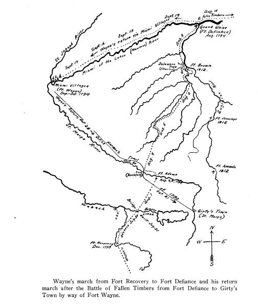
WAYNE'S STRATEGIC ADVANCE FROM FORT
GREENVILLE TO GRAND GLAIZE
BY O. W. PRIDDY
The government of the United States
went into
effect in 1789 and General George
Washington was its
first president. While the new republic
was busily en-
gaged in adjusting its domestic
affairs, an Indian con-
federation was formed in the region of
the Miami of
the lakes (Maumee River) that seriously
challenged the
sovereign power of the national
government in the
Northwest Territory.
In a spirit of defiance, the Indians
proclaimed that
all territory north of the Ohio River
was theirs. The
same territory was coveted by Great
Britain by whom
it was ceded to the United States at
the close of the
Revolutionary War. She sought to
recover it through
an alliance with the Indians and
contributed more or
less to their success in the defeat of
Harmar and the
rout of St. Clair.
The issue of sovereignty over this vast
territory as-
sumed an international aspect when it
became known
that the confederation was organized at
the instigation
of British agents. In reality, the
contest was between
England on the one hand and the United
States on the
other. It was evident to the government
that another
Indian victory would expose the
settlements west of the
Alleghanies to the firebrand and the
tomahawk, and af-
(42)
Wayne's Strategic Advance from Fort
Greenville 43
ford Great Britain the opportunity to
recover the terri-
tory without conquest and annex it to
her Canadian
dominions.
In this crisis, the government
organized a third
army and Washington placed it under the
command of
General Anthony Wayne. The
legion, as the army was
called, marched north from Fort
Washington, (Cincin-
nati) in 1793 to a branch of the
Stillwater River in what
is now Darke County, Ohio. The position
of the legion
was as far north of Fort Washington as
safety would
permit, and here Fort Greenville,
covering fifty-three
acres of ground, was constructed. The
army remained
at Fort Greenville for nearly a year,
and, under the
strict discipline of the commander,
became as well drilled
as any army in the Revolutionary War.
It was pro-
vided with supplies brought up from
Fort Washington.
Wagons and pack-horses laden with
provisions, and
droves of cattle for fresh meat were
protected by the
intermediate forts of Hamilton, St.
Clair and Jefferson.
The two thousand regulars stationed at
Fort Green-
ville were reinforced, on July 26th,
1794, by an army of
Kentucky volunteers under the command
of Major Gen-
eral Scott. And finally, two days
later, the legion began
its eventful march toward the heart of
the Indian con-
federacy. It pushed forward
"without regard to bag
or baggage, as if not in search, but in
actual pursuit of
a flying and disorderly enemy,"
and encamped that
night on the Stillwater. The camps of
the legion cov-
ered about seventy-five acres of ground
and were pro-
tected by breastworks of timber felled
by the army. It
is said that Little Turtle urged an
attack upon the legion
at this place, but the opportunity was
lost because his
44 Ohio Arch. and Hist.
Society Publications
fellow-chiefs disagreed as to the
advisability of making
the assault. The legion passed Fort
Recovery on the
29th and encamped "about half a
mile from the fort."
On the 30th, it reached Beaver Creek
where it was de-
tained the following day, while a
bridge seventy yards
long was being constructed over the
stream and the
swale through which it ran. Proceeding
northeastward,
the expedition crossed the watershed
and entering a
beautiful prairie, crossed Harmar's
Trail of 1790 which
extends through the same from the east
to the west.
The prairie (Shane's Prairie) afforded
"elegant
scenery, handsomely interspersed with
small copses of
trees" and gave the soldiers the
first opportunity to view
the army as a whole.
Wayne avoided the error of Braddock,
who, disre-
garding the advice of Washington,
permitted his army
to march in a long column with a front
no wider than
the road which it was following. The
legion on the
contrary, advanced with a wide front.
The scouts and
spies deployed in every direction. The
front was pro-
tected by a strong guard. The
artillery, the supply-
train, and the live stock followed the
road cut out by the
axemen. At some distance and on both sides
of the
road, the dragoons, the riflemen and
other units marched
in columns parallel with that of the
artillery. The sur-
veyor and the axemen kept in advance of
the army and
were protected by an advance guard of
troops and
scouts. The supply-train, live-stock,
and the rear of the
army were protected "by the
volunteers at supporting
distance in case of attack."
This method of advance explains why
"The dra-
goons and the light troops
sustained," on the 29th, "con-
Wayne's Strategic Advance from Fort
Greenville 45
siderable fatigue and injury from the
thickness of the
woods and brush through which they
passed on the
flanks," and why, on the following
day, the left flank of
the army crossed the Wabash "more
than a dozen times,
but not without great labor both to men
and horses in
plunging through the muddy bed of said
creek."
The reader of the journals can
visualize a level,
swampy and heavily wooded land infected
with mos-
quitoes larger than the soldiers had
ever seen. There
was no water from sparkling streams or
refreshing
springs to quench their excessive
thirst during those hot,
dry days. On the contrary, the water in
the sluggish
streams collected in stagnant pools and
was coated with a
forbidding green scum. However, the
intrepid army
marched on "through thickets
almost impervious,
through morasses, defiles and bends
(beds) of nettels
more than waist high and miles in
length."
The foregoing quotations are from the
journal of
Lieutenant William Clark, a copy of
which is in the
Draper Collection of Manuscripts of the
Historical So-
ciety of Wisconsin. It supplements well
the journal of
Lieutenant Boyer upon which historians
have largely
based their narratives of Wayne's
campaign. However,
Boyer's journal is strangely silent on
the topography of
the country north of the St. Mary's
River, making it
difficult, if not impossible, to
determine the line of march.
On the contrary, the journal of Clark
and the diary of
Hart from the same collection of
manuscripts, make it
possible to locate the route of the
legion by referring to
certain streams, and by definitely
fixing the time when
the legion reached the Auglaize.
It is evident that while the legion was
advancing, the
46
Ohio Arch. and Hist. Society Publications
Indian scouts were observing closely
the line of march.
The young aborigines from the West were
watching in-
tently for the first indications of a
movement toward
the Miami Villages, while runners from
the Auglaize
were reporting to their towns the
direction and progress
of the army.
This phase of the advance--from Fort
Greenville to
the Stillwater, thence to Fort
Recovery, Beaver Creek
and the St. Marys--is easily defined,
but it left the In-
dians in doubt as to whether the route
would finally bend
toward the Miami Villages or toward the
Auglaize. The
scene of activity was then shifted to
the north of the
St. Marys where it was Wayne's policy
to confuse the
Indians by his tactics and elude them
in his march. It
was the policy of the enemy to hang on
the flanks of the
legion hoping to stay its advance by a
surprise attack
at the first opportunity.
Leaving the prairie, the legion came to
a near-by
stream, August 1st, 1794. It was the
little St. Marys
River so frequently mentioned in the
annals of Indian
warfare. The legion crossed the stream
to camp for the
night, but an inspection of the ground
convinced the
commander that the position would be
difficult to de-
fend. It then re-crossed to the south
bank and took a
position "in two columns to
receive the enemy in front
and rear."
It seems to be the general
understanding that the
legion was reinforced by sixteen
hundred Kentucky vol-
unteers, under the command of General
Scott, before it
advanced from Fort Greenville. However,
it appears
from Clark's journal that only a
portion of the volun-
teers were with the main army when the
advance began.
|
|
|
(47) |
48
Ohio Arch. and Hist. Society Publications
Somewhere in the rear of the legion,
nine hundred of
the volunteers, under the command of
General Barbee,
were making forced marches to overtake
the main army.
The commander had reasons to believe
that the lo-
cation of the legion was known to the
Indians. An at-
tack was momentarily expected, and to
make the situa-
tion more uncertain, one Newman of the
quartermas-
ter's department, disappeared. "It is hoped," Boyer
wrote in his journal, "that he
will not give accurate in-
formation of our strength." Many
queries presented
themselves to the minds of the officers
as the sentries
were posted for the first night's
encampment on the St.
Marys. Where are the Indians who
besieged Fort Re-
covery only five weeks ago? Has Newman
informed
them of Barbee's coming, and will they
intercept his ad-
vance and capture his supplies? Where
are the warriors
of Little Turtle? Have they retired to
the Miami Vil-
lages, there to plan, should the legion
advance in their
direction, to defeat it as they
defeated Harmar in 1790?
Or, are they gathering at the Rapids of
the Maumee, to
take their stand under cover of the
fort recently erected
by a British army on American soil?
Captain Wells, the noted scout, and
Captain Kibbey
of the Columbian Scouters, were called
to General
Wayne's headquarters on the morning of
August 2nd
and were ordered to deploy with their
scouts in opposite
directions from the camp. The commander
offered them
rewards for the bringing in of
prisoners whom he might
question for information as to the
plans and position of
the enemy. Wells was a son-in-law of
Little Turtle.
Until recently, he lived from boyhood
among the In-
dians. He knew their ways and was
familiar with their
Wayne's Strategic Advance from Fort
Greenville 49
hunting-grounds. Brave man that he was,
he hesitated
and asked for two hundred men to join
his small party
of scouts, but the commander did not
grant his request.
In the meantime the erection of a small
fortification
was begun. It is referred to by Clark
as Fort Randolph,
but by General Wayne it is
appropriately referred to
as Fort Adams, by which name it has
continued to be
known. Some confusion has arisen as to
the location
of Fort Adams. This is due to the
repeated statement
that the fort was built at Girty's
Town. Girty's Town
was a trading-post conducted by James
Girty, a rene-
gade and a brother of the notorious
Simon Girty. His
store was located on the present site
of the city of St.
Marys, where Wayne caused a fort to be
erected after
the close of the campaign and the
return of the legion
to Greenville.
The site of Fort Adams is on the south
bank of the
St. Marys River, fifteen miles
northwest of the site of
Girty's Town, and but a fraction of a
mile east of the
bridge where the highway running due
north of Celina
to Van Wert crosses that stream.
In the evening of the same day, Wells
and Kibbey
returned. Clark records that "They
made no discovery
except the trace of a horse, and a few
men on foot wend-
ing their way towards the enemy's
settlements. This
led to the belief that Mr. Newman who
had been miss-
ing two days, was taken by the enemy
who were thus
carrying him off."
The erection of the fort proceeded
slowly on August
2nd, and in his eagerness to rush its
completion by the
close of the 3rd, Wayne exposed himself
to danger and
was injured by the falling of a tree.
Happily, when
Vol. XXXIX--4
50
Ohio Arch. and Hist. Society Publications
evening came the fort was so near
completion and the
commander had so far recovered from the
injury that
an order was issued for a forward
movement of the
army on the morning of the 4th. A
reference in Clark's
journal to the injury sustained by the
commander, indi-
cates that in the legion, as in other
armies before and
since then, there was rivalry for
leadership and power.
He declares that the loss of their
commander would
have "deprived particular persons
of their consequence"
and the "downfall of some would
have been equal to the
tumble of our chief, occasioned by the
fall of a large
beech tree."
The weather was hot and dry. The water
was bad
and there was no appearance of rain.
The soldiers
bathed in the river which was teeming
with fish, a num-
ber of which were caught.
Nathaniel Hart of Woodford kept a
"Memorandum
of Occurences in the Expedition of
General Anthony
Wayne." He was with General
Barbee's contingent of
nine hundred men that left Fort
Hamilton on July 28--
the day on which General Wayne began
his advance
from Fort Greenville. On the hot day of
August 3rd,
Barbee's troops marched from Fort
Recovery to Fort
Adams, twenty miles or more, and were
ready to ad-
vance with the main army the next
morning into the
deep forests that lay before them.
Just northward, across the river and in
front of the
army, there lay a scope of land in the
form of a triangle
enclosed by three rivers of which the
St. Marys is on
the southwest; the Miami of the Lakes
(Maumee) on
the northwest; and the Auglaize on the
east. This ter-
ritory comprises the counties of Van
Wert and Paulding
Wayne's Strategic Advance from Fort
Greenville 51
in Ohio, and a portion of both Adams
and Allen in In-
diana. It was heavily timbered and
abounded in wild
game. It was thought that the level and
swampy nature
of the land precluded any attempt to
penetrate the tri-
angle, except in exceedingly dry
weather.
The Miami Villages stood like a
sentinel at the west-
ern angle of the triangle and levied
tribute on the traffic
over the portage to the Wabash, and on
the trails and
rivers converging at that point. The
northern angle of
the triangle is formed by the Maumee
and its tributary,
the Auglaize. This place was referred
to as Grand
Glaize by General Wayne in his letter
of August 14,
1794, informing the Secretary of War
that the army
under his command "took possession
of this very im-
portant post on the morning of the 8th
instant."
The strategic position of Grand Glaize
was apparent
to both the Indians and the invading
army; first, because
of its natural strength, and second,
because of its prox-
imity to the garrison of the British,
who, from their for-
tification down the Maumee, were
providing their In-
dian allies with arms and ammunition
and promising
them assistance and protection which,
at the opportune
time, they failed to give.
Along the boundaries of the triangle,
the Indians
lived in numbers probably exceeding, at
this time, that
of any other equal area in Ohio, while
occasional vil-
lages were found on the higher lands
within. It seems
that their settlements had attained to
some degree of
permanency, for the fertile soil was
contributing
largely to their livelihood. At the
Miami Villages where
Fort Wayne was later built, five
hundred acres of land
were under cultivation and twenty
thousand bushels of
52
Ohio Arch. and Hist. Society Publications
corn were destroyed by Harmar in 1790.
A thousand
acres of corn were growing at Grand
Glaize when
Wayne reached that point five days
later. The army
marched along the Auglaize through
cornfields variously
estimated at from five to seven miles
in length, while the
wigwams and the cornfields along the
banks of the Mau-
mee presented the appearance of an
almost continuous
settlement. Vegetables grew in
abundance and mag-
nificent fruit-trees lined the streams.
The land in which
they were living captivated the
soldiers by its fertility
and beauty.
Wayne had the military instinct to
recognize stra-
tegic values and the good judgment to
seize and fortify
strategic points. To him Grand Glaize
was the "grand
emporium of the hostile Indians of the
west." As the
result of British propaganda against
the United States,
the largest conference of aborigines
ever held in North
America assembled at this place in 1792
to deliberate on
the questions of peace and war. In
Wayne's judgment,
nothing could occur that would tend
more to weaken
their morale and divide their councils,
than to arrive
suddenly and unheralded in their midst
at Grand
Glaize, and then seize and fortify the
most strategic po-
sition. In that event, proffers of
peace would doubtless
be treated with more consideration and
respect; and
then, if he must fight, he would be
sustained by an army
with higher spirits and a still greater
morale. He then
determined to drive forward without
delay and as speed-
ily as possible for Grand Glaize.
The army set out for Grand Glaize on
the morning
of August 4, 1794. Perhaps there was no
event in the
campaign as momentous in its results,
and no decision
Wayne's Strategic Advance from Fort
Greenville 53
so great in its strategy as that
rendered in the choosing
of a route leading from Fort Adams to
Grand Glaize.
Three alternatives presented themselves
to the com-
mander in deciding which route to take.
First, the
legion might march down the St. Marys
River to the
Miami Villages at the head of the
Maumee, as Harmar
did in 1790, and as it was St. Clair's
intention to do in
1791; and then proceed down the Maumee to Grand
Glaize; second, it might march eastward
to the Auglaize
and follow that stream to Grand Glaize;
third, it might
penetrate the triangle above referred
to and reach its
destination by a central and more
direct route.
It was evident that the choice of the
first route might
be regarded and accepted by the Miami
tribes as a chal-
lenge and precipitate a conflict with
Little Turtle, the
victor of both Harmar and St. Clair, on
ground of his
own choice. The second route would
expose the army
to an attack by the Delaware, Ottawa
and allied tribes
who were still inspired by the spirit
of Pontiac who was
born in the vicinity of Grand Glaize.
Furthermore,
from their position to the north and
east of the Maumee,
the Wyandots could, if necessary, quickly
reinforce
either the Miamis on their right, or
the Delawares and
Ottawas on their left. The home of the
brave and rest-
less Shawnees was along the watershed
in the rear. It
is said that they were present at
Penn's treaty with the
Indians. They measured swords with
Washington at
Braddock's defeat and fought valiantly
under Cornstalk
at Point Pleasant. The environment of
their youth was
surcharged with such an intensity of
feeling and oppo-
sition to the intrusion of the whites,
that it impelled the
young Tecumseh to dedicate his life to
the cause of his
54 Ohio Arch. and Hist. Society Publications
people, and henceforth to match his
ability against that
of the whites and particularly against
William Henry
Harrison, a young lieutenant of
twenty-one, in Wayne's
army.
The army was then encircled by the
enemy whom
Wayne planned to hold at a distance;
and he did so by
diverting their attention from the real
route that he
planned to take. Accordingly he
reported to the Secre-
tary of War that he
Made such demonstration as to induce
the savages to expect
our advance to the Miami Villages on
the left, or toward Roche
De Boeuf, or foot of the rapids on the
right--which feints appear
to have produced the desired effect by
drawing the attention of the
enemy to those points, and gave an
opening for the army to ap-
proach undiscovered by a devious i. e.,
in a central direction.
The advance from Fort Adams on August
4th is
vividly described in Clark's Journal as
follows:
Notwithstanding the vulnerable state of
the Garrison, by the
rising of the sun, the beating of the
General was heard to signify
his Excellency's intention to take up
the line of march. Accord-
ingly the army was conducted over the
river, and proceeded
through intolerable thick woods, and the
earth covered with snagly
underwoods, and almost impassable
defiles--however, we reached
a small dirty water, a branch of Glaize
River, after a march of
about twelve miles, and there took up
our encampment for the
night.
Clark did not confine his journal to
the mere state-
ment of facts, but occasionally, the
ardent youth who in
the future was to win fame as a member
of the Lewis
and Clark Expedition, could not refrain
from express-
ing his critical opinion of the
policies of his superior.
He regarded the assignment of
Lieutenant Underhill to
the command of Fort Adams as a
punishment equivalent
to that which an officer should receive
for speaking dis-
Wayne's Strategic Advance from Fort
Greenville 55
respectfully of his superior, if to so
speak were a crime;
and he further wrote:
I can't pass the situation of Lieutenant
Underhill unnoticed;
the officer was left to the command of
Fort Randolph, owing to
his being indisposed; and his command
consisting of no more
than forty invalids. Thus was he left to
finish and defend this
miserable hold, in the midst of the
enemy's country; without the
smallest probability of being reinforced, or aided in
the completion
of the works.
In contrast with Clark's story of the
first day's ad-
vance from Fort Adams, is the brief
record of the same
day in the journal of Lieutenant Boyer
and the still
shorter record in the diary of Hart.
Boyer: Camp thirty-one miles in advance
of Fort Recovery,
August 4, 1794.
----The aforesaid garrison being
completed, Lieutenant Un-
derhill, with one hundred men, left to
protect it; departed at six
o'clock and arrived here at, three
o'clock, being ten miles. The
land we marched through is rich and well
timbered, but the water
scarce and bad; obliged to dig holes in
boggy places and let it
settle.
Hart: Marched with the main army 18
miles and encamped
on a small creek; very bad water that
night.
On the fifth of August the army broke
camp at five
o'clock in the morning and having
marched down the
creek for twelve or thirteen miles went
into camp at four
o'clock. The following records of the
events of that
day have been preserved for us.
Clark: August 5th, '94. Renewed the
march at 5 o'clock--
passed through much such country as
yesterday; kept down the
creek, made about 12 miles.
Boyer: Camp forty-four miles in advance
of Fort Recovery,
August 5, 1794. We arrived at
this place at four o'clock, nothing
particular occurring. The land and water
above described--had
some rain today.
Hart: Marched early and encamped 26
miles from Ft. Ran-
dolph which is on the St. Mary's which
(is) a branch of the
Maumee.
56 Ohio Arch. and Hist. Society Publications
The brief record of August 5th is
significant. For
two days the legion marched in a
"central direction" but
no Indians were seen. Wayne's plan of
eluding them
proved successful. While they were
watching for the
army to appear either on the right or
the left, it was
driving between them like a whirlwind
toward the heart
of their confederacy.
On the third day, August 6th, the army
was ap-
proaching Indian territory which
according to the field
notes of the government survey of
Paulding County was
traversed by Indian paths, trails and
roads, and for the
first time since leaving Fort Adams
signs of the enemy
were discovered. The story of this
day's march is told
as follows:
Clark: Commenced the march as yesterday;
at nine miles
reached a considerable stream called
Upper Delaware Creek--
proceeded three miles down the same, and
there encamped on its
banks. Our spies and about three hundred
volunteers sent in
advance, as supposed near some of the
enemy's villages. Wells
discovered the fresh signs of ten or
twelve near one of the villages
which had been deserted since last fall.
Boyer: Camp fifty-six miles from Fort
Recovery, August 6,
1794.
Encamped on this ground at two o'clock.
In the course of
our march perceived the track of twenty
Indians. I am informed
we are within six miles of one of their
towns on the Oglaize River,
supposed to be the Upper Delaware town.
If so, I expect to eat
green corn tomorrow. Our march this day
has been through an
exceedingly fine country, but the water
still bad--the day cooler
than heretofore.
Hart: Marched early; encamped on a large
creek 58 miles
from Ft. Recovery, water still bad. A
detachment was set off to
attack an Indian town but the place had
been deserted some time.
The scouts who were deploying in every
direction
discovered tracks of the enemy. Rumors
of all kinds
naturally floated in as the army was
nearing its goal, and
Wayne's Strategic Advance from Fort
Greenville 57
a thrill of expectancy swept through
the ranks. The
size of the expedition and the
efficient training of the
soldiers increased their confidence as
they pushed on-
ward, and it was only by the
restraining influence of the
commander that the army was prevented
from running
headlong into the dangers of Indian
warfare. Accord-
ingly, the legion went into camp on the
banks of the
Upper Delaware Creek, at two o'clock in
the afternoon,
to give ample time to erect strong
barricades for its
protection.
A careful investigation has not
produced any map
or record with which to identify any
stream by that
name. However, it is safe to assume
that this name
was applied to the stream because
Delaware Indians
lived in the section through which it
flows.
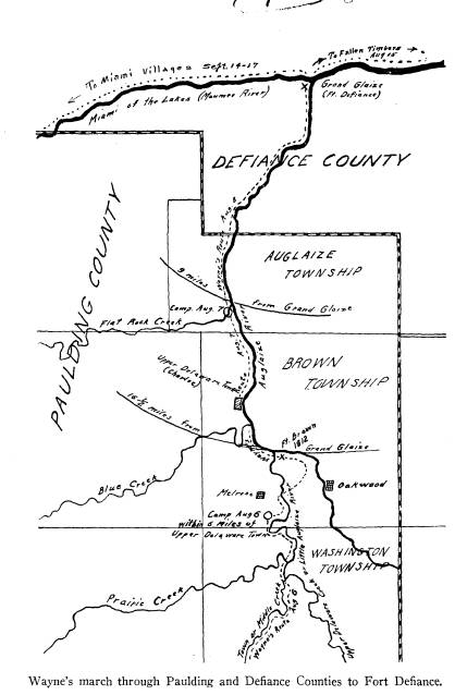
August 7th, marked the last full day's
march of the
army towards its goal, and the
narrative of the events
is as follows:
Clark: August 7th, 1794. Marched at the
usual hour--con-
tinued down the creek five miles to the
Owl town before men-
tioned--halted for an hour, after
crossing the Delaware Creek
and reached the Glaze River, and after a
march of ten miles, we
encamped for the night.
Boyer: Camp 68 miles from Ft. Recovery,
August 7, 1794.
--This day passed the upper town on the Oglaize which
the In-
dians evacuated some time ago. I expect
to see one of their new
towns, where I am told there are all
sorts of vegetables, which will
be very acceptable to the troops. We
have had no appearance of
Indians today.
Hart: August 7. Marched early and
encamped at the Aug-
laize River 61 miles from Fort Recovery.
At the 68th mile tree
we found plenty of roasting ears, beans,
potatoes, etc.
The scouts continued their activities,
and penetrated
the country in all directions. At last
they brought word
that the Indians were abandoning their
homes. General
58 Ohio Arch. and Hist. Society Publications
Wilkinson, the second in command,
envisioned an oppor-
tunity to lead a quick, decisive drive
against Grand
Glaize. But Wayne who was remembered as
the reck-
less and foolhardy captor of Stony
Point in the Revolu-
tion, remembering the admonitions of
President Wash-
ington against a surprise and the
dangers of dividing an
army as Harmar and St. Clair had done,
asserted the
full responsibilities of leadership and
disapproved the
plan that was contrary to his good
judgment.
The feeling of those who desired to
participate in a
surprise attack is well expressed in
these words by Clark:
From our spies we had every reason to
suppose the savages
were abandoning their possessions, and
were not in force to resist
us. This gave an opening for
enterprises. We were now within
twelve or fourteen miles of their
principal settlements; everybody
was flushed with the idea of surprising
(sic) them in the moment
of providing for their wives and
children. The scheme was pro-
posed, and certain success was insured
if attempted. Genl. Wil-
kinson suggested the plan to the
Commander-in-chief, but it was
not his plan, nor perhaps his wish, to
embrace so probable a means
for ending the war by compelling them
to peace. This was not
the first occasion or opportunity which
presented itself to our ob-
servent General for some grand stroke
of enterprise, but the
Commander-in-Chief rejected all and
every of his plans.
Early in the morning of August 8th, the
legion
started on the final march of nine
miles to reach its ob-
jective. As the army marched through
fields of culti-
vated corn, there was little
obstruction and the distance
was covered quickly. The high spirits
of the army is
reflected in the journal narratives for
that day.
Clark: August 8th, '94. Renewed the
march at the usual
time--proceeded down the river to its
confluence with the Miami,
about nine miles, seven of which
through fields of cultivated corn
in the most flourishing situation, and
found their villages just for-
saken; some of the houses were now
burning; they left every ap-
|
|
|
(59) |
60
Ohio Arch. and Hist. Society Publications
pearance of having gone off with
precipitation and the greatest
consternation, which must afford a
mortifying proof of the great
advantage we had let slip.
Hart: Aug. 8. Marched early; large field
of fine corn and
a number of towns along down the river;
arrived at Grandglaize
about 12 o'clock. A most beautiful situation; large fields of
corn
on both sides of the river and the
greatest abundance of every
kind of vegetables. Here Genl. Wayne
encamped on the point and
the volunteers crossed the Maumee and
encamped on the bank.
The great objective, the possession of
Grand Glaize,
was attained. The Indians were
outwitted and deceived.
Masterful strategy enabled an army, for
the first time,
to maintain a position above the
watershed, penetrate
the enemy's country, and reach their
stronghold without
the loss of a man.
With amazement the Indians abandoned
their homes
and only the traitor, Newman, saved
them from cap-
ture. With the loss of their homes,
their morale was
broken. And Little Turtle, who urged an
attack on the
legion, shortly after its advance from
Greenville, now
advised his people to consider well
Wayne's proffers of
peace.
Every foot of ground trod from Fort
Adams to
Grand Glaize bears evidence of the fact
that Fallen Tim-
bers was won before the battle was
fought.
THE IMPORTANCE OF THE ROUTE AND THE
ADVANCE OF
THE LEGION TO GRAND GLAIZE
It seems that this phase of the
campaign has received
scant consideration. Yet, the entire
route and particu-
larly the advance over that portion
from Fort Adams
to Grand Glaize was the key that
unlocked the door to
the region in which the Indians and
their allies were
dwelling in confident but mistaken
security.
Wayne's Strategic Advance from Fort
Greenville 61
The commander was instructed by the
government
to win, if possible, through diplomacy
rather than to
conquer by war. His efforts in that
direction having
been repeatedly foiled by British
influences, he had re-
solved to establish an impregnable
post, at a strategic
place, from which to operate should his
final efforts in
diplomacy fail.
He succeeded in reaching Grand Glaize
by strategy
and its possession was a direct
challenge to British pres-
tige among the Indians. The possession
of Grand Glaize
had to be a reality before a victory at
Fallen Timbers
could be considered a certainty.
Likewise, there had
to be a masterly advance over a
strategic route before
the flag of the new republic could be
unfurled over Grand
Glaize without a battle with an
unbeaten foe.
The battle at Fallen Timbers, the
winning of Grand
Glaize, and the strategy involved in
the advance to it,
were integral parts of Wayne's
campaign.
IS THE SUPPOSED ROUTE FROM FORT ADAMS
DOWN THE
AUGLAIZE VIA FORT JENNINGS SUPPORTED BY
EVIDENCE?
Of all the historians who have written
on Wayne's
campaign, there are only a few who have
made the at-
tempt to trace his route from Fort
Adams to Grand
Glaize. They affirm that the legion
marched northeast
from Fort Adams to the site of Fort
Jennings, of the
War of 1812, and thence down the
Auglaize River to its
junction with the Maumee River. For
reasons already
pointed out in this article, the legion
could not have fol-
lowed the large streams without
revealing both its posi-
62 Ohio Arch. and Hist. Society Publications
tion and objective to the enemy. It
would have been
poor strategy to follow the Indian
trails along the Aug-
laize or the Maumee, but it was good
strategy to avoid
them.
Furthermore, the journal of Clark and
the diary of
Hart clearly show that the Auglaize was
not reached
until August 7th, the day before its
arrival at Grand
Glaize. It was on the same day that
Boyer made his
first positive statement revealing the
advance of the
army along the Auglaize.
In 1882, R. Sutton & Co. of
Wapakoneta, Ohio, pub-
lished an able history of Van Wert and
Mercer coun-
ties. On page 53, an interesting
interpretation of
Boyer's journal, so far as it pertains
to the route through
Mercer County, is given. However, in
describing the
route north of Fort Adams, the author
took a statement
of Boyer out of its proper setting and
applied it to a
wrong date. This error is obvious from
reading the
following statement which appears on
the same page:
At the end of twenty-one miles (It is
probable that the author
meant twenty-three miles) from Fort
Adams the legion was
within six miles of one of the Indian
towns on the Auglaize,
which was supposed to be the Upper
Delaware town, but here the
country was "Exceedingly
fine." This must have been near Fort
Jennings.
Now, according to Boyer, the legion
marched ten
miles from Fort Adams on August 4th and
thirteen
miles farther on August 5th, or a total
distance of
twenty-three miles. It was then, on
August 5th, that the
legion reached a point "twenty-one
miles from Fort
Adams." If the legion advanced, on
this particular day,
to a position within six miles of any
Indian town on the
Wayne's Strategic Advance from Fort
Greenville 63
Auglaize, then it must be conceded that
the location of
the army had to be near Fort Jennings.
Again, if the statement quoted from
Sutton's his-
tory is correct, then the legion was
twenty-one miles
from Fort Adams on August 5th, near
Fort Jennings
on August 5th, and also "within
six miles of one of the
Indian towns on the Auglaize" on
August 5th. But,
was the legion "within six miles
of one of the Indian
towns on the Auglaize" on that
day? Let Boyer's entry
of August 5th answer the question. Here
it is in full:
Camp forty-four miles in advance of Fort
Recovery, August
5, 1794. We arrived at this place at four
o'clock, nothing par-
ticular occurring. The land and water as
above described--had
some rain today.
The entry is devoid of any reference to
the Auglaize
or to any Indian town on the Auglaize.
On the con-
trary, his reference to the Indian town
on the Auglaize
is found in the following entry of
August 6th:
I am informed that we are within six
miles of one of their
towns on the Oglaize River, supposed to
be the Upper Delaware
town. * * * Our march this day has been
through an ex-
ceedingly fine country, etc.
It is now clear that Sutton made an
error in repre-
senting the position of the legion as
being within six
miles of the Indian town on August 5th,
when in fact,
it did not reach that point until
August 6th. It is there-
fore evident that the army was not
necessarily near Fort
Jennings on August 5th, or at any other
time during its
advance toward Grand Glaize.
Sutton's history has not only misled
many readers,
but subsequent writers have repeated
the error. This
is quite evident in Historic
Highways, Vol. 8, page 207,
54 Ohio Arch. and Hist. Society Publications
by Hulbert. The text discloses that the
author made a
personal investigation in the vicinity
of Fort Adams
when gathering material for his series
of books, and no
doubt Sutton's history was consulted by
him. On the
above page, Hulbert says:
On the afternoon of August 6th, the
army reached the banks
of the celebrated "Glaize,"
the Auglaize river.
And further on in the text, he adds:
It (the route) ran northward from Fort
Adams, probably
near Fort Jennings of the War of 1812. * * * etc.
The above quotations are but logical
conclusions
drawn from the erroneous statement
pointed out in Sut-
ton's history. It should be remembered
that Boyer made
no statement in his journal indicating
that the legion
had reached the Auglaize until August
7th, when he
wrote the following:
This day passed the upper town on the
Oglaize.
Lieutenant Boyer's journal is likewise
printed in
full in Slocum's History of the Maumee
River Basin.
Without producing any other evidence,
the author holds
that the legion passed down the
Auglaize River and
was near Fort Jennings when forty-four
miles from
Fort Recovery, or twenty-three miles
from Fort Adams.
It could be said in reply and with
equal force that there
are many other points forty-four miles
from Fort Re-
covery, and for that reason it would be
as logical to
hold that any one of such points, as
may suit the fancy
or imagination, marks the location of
Wayne's trail.
Wayne's Strategic Advance from Fort
Greenville 65
AUGUST 7TH AND 8TH, THE FOURTH AND FIFTH DAYS'
MARCH FROM FT. ADAMS
It has been shown that the theory of
Wayne's route
extending from Fort Adams to the
Auglaize River by
way of Fort Jennings, and thence down
the same to the
Maumee River, is supported by
insufficient evidence. It
is now necessary to marshal all
available evidence in an
endeavor to locate the true course of
the trail. It is
better to begin at Grand Glaize and
work backward, or
rather to proceed from the known to the
unknown.
All authorities agree that the army
marched from
the mouth of Flat Rock Creek to Grand
Glaize on Au-
gust 8th, a distance of nine miles.
They also agree that
a portion of the march on the 7th was
from the junc-
tion of the Auglaize and Little
Auglaize Rivers to the
mouth of Flat Rock Creek, a distance of
seven and one-
half miles, or sixteen and one-half
miles from Grand
Glaize. It was upon this march that the
legion passed
the Upper Delaware town (Charloe)
referred to by
Boyer in his journal entries of the 6th
and 7th. There-
fore, it must have marched four and
one-half miles be-
fore it reached the junction of the two
rivers; or, in
other words, it broke camp on the
morning of the 7th,
four and one-half miles from the
junction, or twenty-
one miles from Grand Glaize.
Where, then, was the camp located? In
the first
place, this is the camp referred to by
Boyer, on August
6th, as being fifty-six miles from Fort
Recovery, and
also within six miles of the Indian
town on the Auglaize.
Thus Boyer gives distances but no other
evidence by
which the site of the camp can be
located. However,
Vol. XXXIX--5.
66
Ohio Arch. and Hist. Society Publications
Clark states that the encampment was
three miles down
"a considerable stream called
Upper Delaware Creek,"
while Hart states that the army
"encamped on a large
creek." During the morning's march
of four and one-
half miles, the army "halted for
an hour, after crossing
the Delaware Creek and reached the
Glaize River."
The camp was not on the Auglaize River,
but on the
"Upper Delaware Creek."
By what name is the "Upper
Delaware Creek" now
known? It would be well at this point
to ask a question
and let the answer stand as a solution
of the problem.
What "considerable stream" or
what "large creek" is
there, that can be crossed above the
junction of the
Auglaize and Little Auglaize rivers,
within six miles
of Charloe, or within four and one-half
miles of the
junction, or within twenty-one miles of
Grand Glaize?
An inspection of a map will reveal the
fact that the
Little Auglaize River is the only
stream that can be
crossed within the limits mentioned.
Therefore, the "Upper Delaware
Creek" and the
Little Auglaize River are but different
names for the
same stream, and the camp was located
on the Little
Auglaize.
It is not improbable that when the army
crossed the
Little Auglaize, it made a circuit
toward the present
site of Oakwood and rested at the
junction of the rivers,
where Fort Brown was erected during the
War of
1812. Here, in the words of Clark, the
army "halted
for an hour," or in the words of
Hart, it "encamped at
the Auglaize River 61 miles from Fort
Recovery," but
it continued its march to the 68th mile
tree (Flat Rock
Creek) where a plenty of roasting ears,
beans, pota-
|
|
|
(67) |
68
Ohio Arch. and Hist. Society Publications
toes, etc.," were found. The
information gleaned from
the journal of Clark and the diary of
Hart is corrobo-
rated by a letter of Major Jonathan
Haskell, an officer
in the legion, who in a letter written
August 29, 1794,
states in part that
We then crossed the St. Marys and in
four or five days'
marching found the Auglaize River, and
continued on down that
stream to its junction with the Miami
of the Lake; distance 100
miles from Greenville by the route we
pursued.
This letter is found in an old book, Pioneer
Settlers
of Ohio, Second Series, page 347.
Here we have the written evidence of
three mem-
bers of Wayne's army proving that the
Auglaize was
not reached until the 7th. It
effectively disproves the
position of Hulbert that the Auglaize
was reached on
the 6th, and clearly shows that the
legion did not march
from Fort Jennings down the Auglaize.
The events of August 7th, 1794, may be
summarized
as follows: The army broke camp on the
Little Aug-
laize River, marched a short distance
and crossing that
stream came to the Auglaize River;
after halting for
an hour, it proceeded down the
Auglaize, passed the
Upper Delaware town (Charloe) and went
into camp
at the mouth of Flat Rock Creek, nine
miles from
Grand Glaize.
AUGUST 6TH, THE THIRD DAY'S MARCH FROM
FORT
ADAMS
It was on August 6th that the legion
"reached" the
Upper Delaware Creek, or the Little
Auglaize River,
and marched three miles down the same
before going
into Camp. Since the legion
"reached" the Little Aug-
Wayne's Strategic Advance from Fort
Greenville 69
laize after marching nine miles, it is
obvious that it had
not been following that stream. It is
well to keep this
fact in mind, should the idea be
advanced that the route
led from Fort Adams along the entire
length of the
Little Auglaize. On the preceding day
the army "kept
down the creek" which Clark called
the "small dirty
water," and there is nothing to
indicate that it did not
continue to keep down the same on the
6th.
In what direction was the army marching
when it
reached the Little Auglaize? Now, all
tributaries of
the Little Auglaize flow from the
southwest. There-
fore, when the legion was marching down
the "small
dirty water" it was approaching
the Little Auglaize
from the same direction. Prairie Creek
cannot be iden-
tified as the "small dirty
water," because its course is
too far north, while Dog Creek is too
far above the
junction of the streams. All evidence
points to the
identification of the stream known as
Middle Creek in
Paulding County, or Town Creek in Van
Wert County
(known on early maps as the Middle Fort
of the Little
Auglaize) as the "small dirty
water."
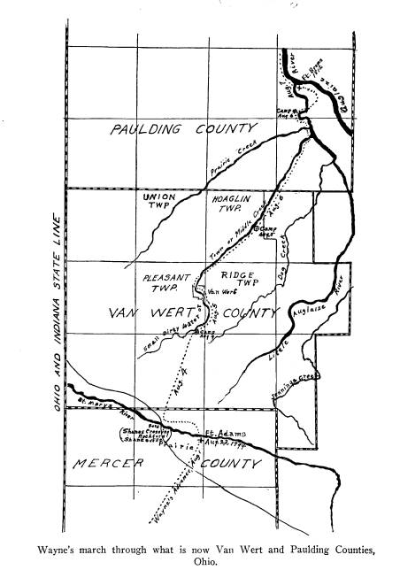
The route of the legion, on August 6th,
extended
from the northeast part of Hoaglin
Township, Van
Wert County, along Town or Middle
Creek, to the Lit-
tle Auglaize and continued down that
stream for the
distance of three miles to a point near
Melrose.
AUGUST 5TH, THE SECOND DAY'S MARCH FROM FORT
ADAMS
For twelve or thirteen miles the legion
"kept down
the creek" from a point about
three miles south of Van
Wert to the northeast part of Hoaglin
Township. The
70 Ohio Arch. and Hist. Society Publications
bank of the creek afforded an admirable
route for the
advance of the legion. A road
conforming closely to
the trail was located in 1825--ten
years before the city
of Van Wert was laid out. There are
people still living,
both north and south of the city, who
in their youth
knew the road as the "Defiance
trail," "Wayne's trail"
or "Wayne's trace." This
tradition is affirmed on page
190 of Sutton's history, where the author,
in referring
to the early settlers of Pleasant
Township in which the
city of Van Wert is located, states
that
In the region of Piqua, 60 miles south,
the necessaries of life
were more abundant, to which these
settlers directed their way;
and the water-mills were peculiarly
attractive. General Wayne's
trail, leading from St Mary's to Fort
Defiance was the line of
travel going south for provisions.
In other words, the settlers followed
Wayne's route
south to Shanesville (Rockford) and
then followed the
trail over which the legion proceeded
to Girty's Town
(St. Marys) on its return march to Fort
Greenville.
The statement just quoted directly
contradicts the state-
ment on page 53, in the same history,
where the author
says that when the legion was twenty-one
miles from
Fort Adams, it must have been near Fort
Jennings.
There is a manuscript in the Brumback
County
Library of Van Wert, written by the
late Judge H. C.
Glenn, who in referring to Wayne's
trail, says:
This trail was quite visible from Van
Wert north when we
came to the village in 1847. I have
passed over it many times.
The then visible trail started at a
point near the Second Methodist
Church and followed closely Town Creek
crossing the same on
what is known as the Ketchem land north
of town and following
closely the creek, avoiding the abrupt
bends of the same, passing
very closely to the four corners of
Ridge, Pleasant, Hoaglin and
Union Townships. From the course of the
trail at the point first
Wayne's Strategic Advance from Fort
Greenville 71
named it must have crossed the Ridge,
now Main Street, and the
creek near the Old Cemetery.
The last time I have any recollection of
passing over the trail
was on Thanksgiving day, 1863. Instead
of attending Thanks-
giving services as I should have done, I
spent the day squirrel-
hunting, passing down the trail and
returning by the Defiance
Road. At that time there was no improved
land north of the
Strother land and the trail was followed
with much ease.
The essential points to note in the
above quotation
are that the "then visible portion
of the trail" started
on the right side of the creek, and
that the Ketchem
land, which lies north of the Strother
Land, was there-
fore unimproved. The trail running
through the un-
improved land crossed to the left side
of the creek and
following the stream passed very closely
to the four
corners of Ridge, Pleasant, Hoaglin and
Union town-
ships.
It must have re-crossed the stream, but
before re-
uniting with the road, it ran a short
distance between
the same and the creek. The highway is
located on the
right side of the stream, and its
location, in relation to
the latter, has never been changed. Since
there never
was a road on the left side of the
stream, it cannot be
said that this portion of the trail was
an abandoned
highway. Just before the trail reached
the road (State
Road No. 9) bending north from the
highway and lead-
ing to Paulding, it ran between the
creek and highway
and is still remembered by the older
citizens. John R.
Spears, author of a life of Wayne, and
whose boyhood
days were spent in Van Wert, was
familiar with it, and
has informed the writer that it was like
an old aban-
doned loggers' road into the wilderness
and was pretty
well filled up with second growth. He
was assured by
72
Ohio Arch. and Hist. Society Publications
his father, who was a surveyor and the
first Mayor of
Van Wert, that this was Wayne's trace.
It is stated in Gilliland's History
of Van Wert
County, on page 53, that Wayne passed through Van
Wert on what was known to the early
settlers as the
Defiance trail; and again, on page 58,
that what is
known as Wayne's trail was visible from
Van Wert
north for many years after the
settlement of the county.
AUGUST 4TH, THE FIRST DAY'S MARCH FROM
FORT
ADAMS
The legion was 'conducted' over the
river and was
about to penetrate a scope of land
through which no
army had marched before. The objective
of the army
was unknown to the enemy. Hulbert (Historic
High-
ways, Vol. 8, page 208) says "While at Fort Adams,
Wayne had made feints at cutting two
roads, one down
the St. Marys River and another
northwest (he must
have meant northeast) straight towards
Roche de Boeuf.
These routes were both opened for some
distance, that
down the St. Marys at least as far as
the famous ford at
Shane's crossing--the present
Rockford." Early set-
tlers tell of a road that formerly ran
northeast from Fort
Adams, a remnant of which is still in
use near Jones-
town, in Van Wert County. This is the
road referred to
by Hulbert, and may have been in use as
a portion of
the line of communication between Fort
Adams which
was re-occupied during the War of 1812,
and Fort Jen-
nings, which was erected during the
same war.
Now, Harmar's trail of 1790 extended
from Girty's
town (St. Marys) northwest to the St.
Marys River,
and crossing the ford at Rockford
continued in the same
Wayne's Strategic Advance from Fort
Greenville 73
direction to the Miami Villages (Fort
Wayne). The
road, "down the St. Marys,"
referred to by Hulbert, ran
as far west as Harmar's trail. By
marching over this
road on the morning of the 4th, Wayne
made a demon-
stration toward the west which
convinced the Indians
that he was advancing on the Miami
towns. But instead
of continuing on Harmar's trail, the
legion turned north-
ward and "after a march of about
twelve miles" "reached
a small dirty water" where it
encamped for the night.
According to Clark, the legion had to
contend with "in-
tolerable thick woods, snagley
underwoods and almost
impassable defiles." The defiles
run at right angles with
the river. To this day, in driving
parallel with the river
over a highway conforming closely to
the trail from the
fort to Rockford, one must cross at
least five bridges
over streams flowing through little
valleys or ravines
which are the vivid reminders of a
toilsome and difficult
march. On the other hand, the route
that ran northeast
to the Little Auglaize did not cross
any defiles but ran
parallel with them. Furthermore, the
Little Auglaize
would have been reached not "after
a march of about
twelve miles" from the fort as the
"small dirty water"
required, but after an advance of only
three or four
miles. Hart records a march of eighteen
miles. This is
accounted for by the fact that a
demonstration was prob-
ably made toward the northeast, by the
volunteers who,
after marching three or four miles,
returned and joined
the main army.
These facts prove that the route of the
legion was
not along the Little Auglaize River.
They prove that
after crossing the St. Marys River, the
route extended
west toward Rockford and then turning
north reached
74 Ohio Arch. and Hist. Society Publications
Town Creek about three miles south of
Van Wert. It
then followed Town Creek, the Little
Auglaize and
lastly, the Auglaize River to the
Maumee.
In 1824, the General Assembly of Ohio
passed an
act to locate and establish a series of
roads, the eighth
of which was designated in the act as
A state road from Shanesville in Mercer
County, to Defiance
in Williams County.
Joseph Green and Anthony Shane were
appointed
as commissioners and James Watson Riley
as the sur-
veyor to locate the road. Riley was one
of the found-
ers of the county-seats of Celina, Van
Wert and Pauld-
ing. Shane was of French-Shawnee blood.
He aided
the Indians in resisting the
encroachment of the whites
but in the War of 1812 he served as a
faithful scout
for the government. He knew Tecumseh,
the Shaw-
nee, intimately. His manuscript journal
of the life of
Tecumseh is in the Historical Society
of Wisconsin and
has been used freely by the writers of
history and
biography. The government conveyed to
Shane a sec-
tion of land on which he was then
living and where, in
1820, he founded the town of
Shanesville, now Rock-
ford. In the same vicinity the
government also con-
veyed lands to Black Loon, Charlie,
Crescent, Peter La-
badie and the Godfreys. To this
community, rich in
historic lore, Henry Howe came and in
his chapter on
Mercer County, in Howe's Historical
Collections of
Ohio, he wrote:
At this spot Wayne's army crossed going
north, and the spot
eventually became known as Shane's
Crossing.
While the legion did not cross
precisely at Rock-
Wayne's Strategic Advance from Fort
Greenville 75
ford, it did, however, proceed north
from Rockford on
its final drive.
Having been a participant in the Indian
Wars and
being acquainted with the network of
streams and trails
in this section, Shane was well
qualified to locate a new
road on the best route. Accordingly,
the commission-
ers located a road from Shanesville to
the mouth of the
Little Auglaize where it intercepted a
road from St.
Marys to Defiance that followed Harrison's
trail of the
War of 1812. The wisdom of Wayne's
choice of a
route was confirmed by the return of
the proceedings
of the commissioners certifying that
the road had been
laid out on the "nearest and best
ground." Although
the road was located in 1825 it was not
improved until
1830. Contracts for the improvement
were awarded
to the lowest bidders and it was
stipulated, among other
things:
All the standing timber twelve inches
(in) diameter and
under to be taken out no stumps exceed-----inches in
height all
old timber to be removed and the road to be cleared
eighteen feet
wide which will be sold in lots from one
to three miles, etc.
Seven miles of the road were improved
for less than
six dollars per mile, while the highest
cost was for three
miles at $16.87 1/2 per mile. The banks
upon which the
road was located were heavily wooded
and it is hardly
conceivable that a road could have been
improved all
the way through Van Wert County without
removing
some large timber, unless, on some
former occasion,
timber both large and small had been
removed to make
a passable road. This fact, added to
the evidence al-
ready produced, shows clearly that the
road was located
over Wayne's trail and that his axemen
felled sufficient
76 Ohio Arch. and Hist. Society Publications
large timber to make the transportation
of artillery and
supplies possible. Both trail and road
were located on
the "nearest and best
ground."
This trail led directly into the heart
of the Indian
country, and into territory dominated
by British influ-
ences. The first well-organized army of
the United
States was enabled by marching over
this route, to
shake off and confound the enemy.
The strategy conceived by the commander
was ex-
ecuted at Fort Adams and bore fruit at
Grand Glaize
in a surprised and fleeing foe. The
evidences of victory
began to appear when the legion plunged
into the dark
forests above the St. Marys, and was
made a certainty
when it emerged on the banks of the
Maumee. It spurred
the army on, and bristling cannon from
the British
fort could not intimidate it. This
trail marks the first
phase of an aggressive campaign, and
the aborigines
learned from it that they were opposed
by a com-
mander who could not be led into
ambush, but who could
choose his own route and follow it to
victory. That
march convinced the Indians that the
United States
was determined to exercise the powers
of sovereignty
in her own territory. It demonstrated
to the British
that a growing national consciousness would
no longer
countenance the occupation of American
territory by a
foreign power. The route led to a
victory both national
and international in its aspect, and
the sovereign power
of the United States over her territory
was never
seriously challenged again.