Ohio History Journal
ROBERT A. WHEELER
Land and Community in Rural
Nineteenth Century America:
Claridon Township, 1810-1870
In 1812 Horace Taylor of Hartland,
Connecticut, traveled to Ohio to
buy and settle lands in the Western
Reserve of Connecticut on the
Trans-Appalachian frontier. He chose a
relatively new township in the
heart of the Reserve later called
Claridon in Geauga County. There in
the western portion he located his
farm, helped found the Congrega-
tional church, and established one of
the backbone families of the
township. Ten years later Nathaniel
Mastick arrived from Vermont and
started a farm in Claridon's eastern
portion. His family also became
one of the backbone families of the
township.
In some ways these two settlers were
typical of the two major
migrant groups who peopled the northern
portion of the Trans-
Appalachian frontier. Initially, most
settlers came to northern Ohio
directly from their ancestral homes in
New England just as Taylor had
done, and for a number of years these
pioneers attracted other family
members and associates to their new
settlements. As this group
declined after 1820, a new group, part
of what Malcolm Rohrbough has
called the "first great
migration" of the Trans-Appalachian frontier,
increased the volume of pioneers.1 Many
of them had moved from old
New England after the Revolutionary War
and established new homes
in frontier areas of Vermont, New
Hampshire, and New York. Some,
like the Masticks who moved from Connecticut
to Vermont, became
disenchanted with these homesteads, saw
opportunity further west in
an area settled by New Englanders, and
moved again to Ohio. Both
groups mingled throughout northern
portions of Ohio, Indiana, and
Illinois. Both Taylor and Mastick were
also typical because they
Robert A. Wheeler is Associate Professor
of History at Cleveland State University.
1. See Malcolm J. Rohrbough, The
Trans-Appalachian Frontier: People, Societies,
and Institutions, 1775-1850 (New York, 1976), 157-91 (hereafter cited as Rohrbough,
Frontier).
102 OHIO HISTORY
brought with them a set of regional
values characterized by their
Yankee-Puritan heritage.2 The
township they settled was typical of the
northern frontier in superficial
demographic and economic ways, and
its gradual integration into regional
and national contexts can be
precisely traced. The picture painted by
these indicators implies that a
homogenous, cohesive New England-New
Connecticut society devel-
oped in Claridon township. But closer
analysis of land records, maps,
church records, and especially diaries,
reveals a hidden and significant
division in neighborhood patterns and
social networks. These layers
meant that the Taylors and the Masticks
and the groups they symbolize
became part of separate subcultures
within Claridon which rarely
mixed.3
In order to explain how these
developments took place, the demo-
graphic and economic context which
produced the smokescreen of
homogeneity needs to be explained. Also
necessary is a closer exam-
ination of the settlement patterns and
the evolution of local township
centers which begin to suggest the
emergence of subcultures. Finally,
an analysis of church affiliation,
residence, and social networks
confirms the virtual bifurcation of
Claridon by the 1860s.
I. Population
During the era of the Trans-Appalachian
frontier, from its opening at
the beginning of the Revolutionary War
to its closing seventy-five years
later, thousands of migrants flooded the
West. As they founded new
2. Rohrbough, Frontier, 66, 150,
152; Thomas J. Schlereth, "The New England
Presence on the Midwest Landscape,"
The Old Northwest, 9 (Spring, 1983), 128-42
(hereafter cited as Schlereth, "New
England Presence"); Kenneth V. Lottich, "Cultural
Transplantation in the Connecticut
Reserve," Historical and Philosophical Society of
Ohio Bulletin, 17 (July, 1959), 154-66 and "The Western Reserve
and the Frontier
Thesis," Ohio Historical
Quarterly, 70 January, 1961, 45-57; David French, "Puritan
conservatism and the Frontier: The
Elizur Wright Family on the Connecticut Western
Reserve," The Old Northwest, 1
(March, 1975), 85-95.
3. Two general histories of the township
published as essays in histories of Geauga
county have the most detailed
information: History of Geauga and Lake Counties, Ohio
with illustrations and biographical
sketches of its pioneers and most prominent men
(Philadelphia, 1878), 167-74 (hereafter
cited as History of Geauga) and Pioneer and
General History of Geauga County with
sketches of some of the pioneer and prominent
men (Historical Society of Geauga County, 1880, facsimile
reprint Evansville, Indiana,
1973), 376-415 (hereafter cited as Pioneer
History). I have used a complete set of local
records located in the Geauga County
library branch in Chardon, Ohio. Maps used in
tracing the history of land ownership
were located in the County Recorder's Office in
Chardon. Most helpful were the guides
and collections of Jeanette Grosvenor, a life-long
resident of Claridon and a genealogist.
She had indexed the federal censuses, local
Congregational records, and had many of
the diaries.
Land and Community 103
communities or joined ones already
started they participated in the
gradual maturation of the entire region.
Some of these settlers came to
that northeastern portion of Ohio known
as the Western Reserve. The
area had been granted to the state of
Connecticut by the United States
government and was subsequently sold to
a group of investors called
the Connecticut Land Company in 1795.4
Surveying parties finished dividing up
the area and settlers began to
trickle onto the land before the turn of
the nineteenth century.
Apparently Claridon township, which
consisted of twenty-five square
miles, was attractive, for four groups
of investors purchased it and
hired surveyors to divide it into
smaller tracts. Perhaps investors were
impressed with the fertile dense clay
soil, common to the area, or the
abundant water resources supplied by the
two branches of the Cuyahoga
River which, separated by a ridge of
well-drained land, pass through
Claridon.5 In any case, the
first settlers arrived in 1810 followed by an
increasing stream of newcomers who
totalled 402 by 1820.6 Like most
Reserve townships founded during this
time, Claridon rapidly gained
population until 1840 when 900 people
lived within its boundaries.7
Also typical was the fluctuation of
population over the next three
decades, as the inhabitants rose by over
100 in 1850 and then dropped
back to 910 in 1870.8 Correspondingly,
the number of households grew
rapidly from 63 in 1820 to 172 in 1840.
A decade later it increased to 197
and then leveled off. Clearly Claridon's
population had made it part of
the settled rural hinterland.
Other demographic measures detail the same
gradual change. The
ratio of males to females favored males
in the initial stages of
settlement (there were 125 males per 100
females in 1820), as one would
expect. However, there were enough women
to suggest that, although
single adult males did migrate, young
families made up a large
proportion of Claridon's early settlers.
By 1850, just as the number of
people and households was leveling off,
virtually the same number of
4. See Harlan Hatcher, The Western
Reserve; The Story of New Connecticut in Ohio
(Indianapolis, 1948). See also Edmund
Chapman Cleveland: Village to Metropolis
(Cleveland, 1964), 1-8 (hereafter cited
as Chapman, Cleveland).
5. History of Geauga, 167-68: Pioneer History, 377-79.
6. The following analysis is based on
the federal census manuscripts for the years
1810 through 1870 located at the Western
Reserve Historical Society, Cleveland, Ohio.
7. Don R. Leet, "Population
Pressure and Human Fertility Response: Ohio,
1810-1860" (Ph.D. dissertation,
University of Pennsylvania, 1972), Table 2.3, 24-25
(hereafter cited as Leet,
"Population Pressure"); Robert A. Wheeler, "The Town in the
Western Reserve, 1800-1860," The
Western Reserve Magazine, 6 (May-June, 1979),
special insert (hereafter cited as
Wheeler, "The Town").
8. Leet, "Population
Pressure," 25; Wheeler, "The Town," passim.
104 OHIO
HISTORY
males and females lived in the township.
Two decades later there were
fewer males (93 per 100) than females, a
characteristic of older stable
areas.9
This gradual stabilization of population
was produced in part by a
change in the fertility of Claridon
women. As one would expect,
women in Claridon, like their
counterparts in the rest of early Ohio,
had high fertility in the first decade
of settlement. Most were of
childbearing age and they brought some
children with them and had
more soon after they arrived.10 In
the succeeding two decades their
fertility dropped dramatically-more
quickly than most observers have
found so that by 1840 it was 50 percent
lower.11 Not surprisingly, the
downward trend continued into the 1870s,
by which time it was a little
more than one-third of the 1820 rate. It
is likely that very early in the
history of the township, women, even
those newly-married, were
having fewer children. They were doing
so long before out-migration
and the declining proportion of males
forced declines in the fertility
ratio. The drop, as will be shown, was
caused by a decline in available
land, which local residents apparently
perceived as a loss of opportu-
nity.
Within this environment geographical
mobility and birthplace of
residents reflect the maturing local
society. While one might expect
9. The gradual shift of sex ratios from
male dominated to female dominated as an
area matures is generally accepted. For
one overview see Richard C. Easterlin, George
Alter, and Gretchen A. Condron,
"Farmers and Farm Families in Old and New Areas:
The Northern States in 1860" in
Tamara Hareven and Marus Vinouskas, eds., Family
and Population in Nineteenth-Century
America, (Princeton, 1978), 22-84
(hereafter cited
as Easterlin, "Farmers").
10. The fertility ratio is the number of
children from birth to 9 years old divided by the
number of women from the ages of 16 to
44. In the first decade of settlement it is 2260.
See Leet's discussion of the fertility
of Ohio women, particularly his comments on
Northeastern Ohio women in
"Population Pressure," 51; also Don R. Leet, "Human
Fertility and Agricultural Opportunities
in Ohio Counties: from frontier to maturity,
1810-1860" in David C. Klingaman
and Richard K. Vedder, eds., Essays in Nineteenth-
Century Economic History: The Old
Northwest, (Athens, Ohio, 1975), 145
(hereafter
cited as Leet, "Human
Fertility"). No similarly detailed study of fertility is intended
here, but the comparisons do suggest a
similar trend with some exceptions.
11. The figure is 1080. Leet argues that
those in the predominately New England
northeastern quadrant of Ohio had the
lowest fertility of any migrant group and
continued the trend after they became
Ohioans. Claridon fits this pattern, but Leet does
not account for this drop in fertility;
he simply notes it. See Leet, "Human Fertility,"
152-53. See also James Q. Graham, Jr.,
"Family and Fertility in Rural Ohio: Wood
County, Ohio in 1860," Journal
of Family History, 8 (Fall, 1983), 262-78 (hereafter cited
as Graham, "Family and
Fertility"). Graham uses more sophisticated techniques and a
different measure of fertility than
Leet, but for Claridon his technique, which requires
the detail of the census manuscripts
from 1850 onward, could not be used, and thus the
seemingly critical drop in the 1840s
would not be observed. Wood County in the western
portion of the state was settled much
later and would not have a similar problem.
Land and Community
105
migrants to remain in a newly-opened
area, especially if they were
household heads, the high rate of those
who stayed from decade to
decade over the entire time period is
nevertheless surprising.12 The
decennial persistence of household heads
was 54 percent for both 1830
and 1840. Even at mid-century the rate
dipped only slightly to 48
percent, and by 1870 it was still nearly
45 percent.13 In other words,
while some out-migration among young
adults and reduced fertility
among residents probably occurred, a
very high proportion of resident
household heads remained from decade to
decade, creating a stable
and potentially cohesive township.
Furthermore, more township residents,
particularly those who
stayed, were ethnically homogeneous
since Claridon, unlike the area's
cities, did not attract foreign
immigrants. In fact, Claridon's proportion
of foreign-born adults was generally
less than 5 percent.14 Predictably,
New Englanders predominated. In 1850,
when the federal census first
listed birthplace, the largest group of
migrants, 33 percent, came from
Connecticut. There were also large
contingents from Massachusetts,
10 percent, and the recently expanded
states of New York, 20 percent,
and Vermont, 9 percent. These migrations
came somewhat later than
the initial one from Connecticut.
Consequently, by 1870 only 16
percent of township adults were
Connecticut-born, whereas over
one-fourth, or 27 percent, of the adults
were born in the other three
states. By 1870 the first Ohio-born
generation had matured and
comprised half of all adults and nearly
two-thirds of those under fifty.
This gradual change gave Claridon a
decidedly native character.15
12. In the following discussion the
proportion of those who stayed is understated
because no accurate way of determining
which residents died during the period is
available and, therefore, all residents
who did not remain were judged to have left the
area. For a discussion of geographical
mobility among a very mobile population, see
Rebecca A. Shepherd, "Restless
Americans: The Geographic Mobility of Farm Labor-
ers in the Old Midwest, 1850-1870,"
Ohio History, 89 (Winter, 1980), 25-45. Her finding
that 21 percent of farm laborers stayed
each decade suggests that even this segment was
more stable, even though her analysis is
not specific to the Western Reserve. The
findings of Jack Blocker, who argued
that agricultural specialization can increase the
need for farm laborers while not
increasing the need for more farms, probably account
for these data. See his article,
"Market Integration, Urban Growth and Economic
Change in an Ohio County,
1850-1880," Ohio History, 90 (Autumn, 1981), 298-316.
13. Household members are not listed
separately on the federal census until 1850.
14. The key indicator of the shift from
immigrant to native is when the proportion of
adult residents become native. For this
reason only those over 21 years of age are
included. In the 1830s and 1840s most
native Ohioans were still children.
15. Much of the preceding discussion of
the evolution of Claridon fits into the patterns
discussed by Richard Easterlin, et al.,
for a much wider area in 1860. See Easterlin,
"Farmers," 22-84.
106 OHIO HISTORY
II. Economy
Part of the reason for the consistency
of most demographic indica-
tors was the economic evolution which
transformed Claridon and most
of the Reserve from an isolated frontier
area to a countryside dotted
with prosperous specialized dairy farms.16
Using Edward Muller's
construct, up to 1830 Claridon was part
of the "Pioneer Periphery,"
the first stage in an area's search for
economic viability, when its
residents established permanent
settlement, cleared land for agricul-
tural production, and searched for
exportable crops.17 Gradually,
during these two decades, residents
purchased tracts so that by 1820
they owned five thousand acres and ten
years later they owned the
entire fourteen-thousand acre township.
The average farmer owned
145 acres of land on which he grazed
five cows.18
After 1830 the area became part of the
"Specialized Periphery," a
second stage marked by demand for the
area's products on a regional
or even national level. During this
period settlement intensified and
interregional connections and
specialized staple production developed.
In Claridon, since all land was already
owned, this intensification
meant that the number of owners
increased by two-thirds, which
reduced the average holding to
eighty-eight acres by 1840, a drop of 40
percent. Significantly, this reduction
caused residents to respond to the
declining availability of land by
dramatically reducing their fertility by
one-third.19 The trend
continued to mid-century when another one-
fourth increase in owners further
reduced the average size of a farm to
seventy-three acres and caused fertility
to drop even further. These
16. For a general introduction see R.
Douglas Hurt, "Dairying in Nineteenth-century
Ohio," The Old Northwest, 5
(Winter, 1979-80), 387-99. See also Robert A. Wheeler,
"Agriculture in the Western
Reserve, 1800-1860," The Western Reserve Magazine, 5
(January-February, 1978), special
insert.
17. Edward K. Muller, "Selective
Urban Growth in the Middle Ohio Valley,
1800-1860," Geographical Review,
66 (April, 1976), 178-204.
18. In 1820, 100 percent of the farm
owners owned cattle and 95 percent did so in
1830. The two-thirds who owned any
horses owned one each in both years. County tax
records called Tax Duplicates were used
for land ownership, and personal property lists,
also part of the county taxation system,
were used to determine the number of animals
for the appropriate years. All are
located in the Geauga County Library, Chardon, Ohio.
19. The ratio fell from 1500 in 1830 to
1080 in 1840. There is extensive literature on the
relationship between available land and
the declining fertility of American women in the
nineteenth century. It basically argues
that, as resources measured in available land were
progressively more difficult to obtain,
family size dropped, especially in frontier areas.
This study of Claridon suggests that it
was not a generational phenomenon but happened
virtually as soon as the land pressure
first appeared to local residents. See Leet, "Human
Fertility," 145, 156-57, who
suggests that for the whole state the transitions came later
and Graham, "Family and
Fertility," 271-73, for a brief discussion of the literature.
|
Land and Community 107 |
|
|
|
progressively smaller tracts accommodated a new specialized form of farming, dairying. By mid-century three-fifths of township real estate was meadowland while only 10 percent was plowland.20 Virtually all local farmers participated in dairying by increasing their herds four- fold-from five in 1830 to an average of twenty by 1860. The milk produced supplied several local cheese factories.21 The extent to which farm economy dominated Claridon is obvious from the occupations of residents. In 1850 fully 70 percent of those employed were farmers or farm laborers, and most of the remainder supported the rural economy as blacksmiths, wagonmakers, or carpen- ters. Twenty years later much the same situation existed except for the addition of several owners of cheese factories, an engineer, a machin-
20. The remainder was categorized as woodland. The 1853 and 1870 duplicates indicate the precise number of acres in each of the three categories. 21. Claridon farmers also joined the era of mechanized farming as they increased their commitment to farm machinery from sixty-three to two hundred thirty dollars over the decade ending in 1860. A further refinement in the local economy came when the dairy industry converted from cheese to butter production in the early 1870s. In 1850 and 1860 federal agricultural censuses were taken which detailed this local economy. Copies of the censuses are located at the Ohio Historical Society library in Columbus, Ohio. The federal population schedule shows one cheese factory in 1850 and several later. See also History ofGeauga, 170 and Pioneer History, 410. |
108 OHIO HISTORY
ist, and more shopkeepers.22 Thus
Claridon had evolved into a
township with an impressively stable
population firmly committed to
making a livelihood from dairy farms.
But even though Ohio-born dairymen came
to dominate the town-
ship, the associations which their
forefathers created left indelible
marks on the geography of the township
and on its sense of community.
As will be shown below, these
associations fixed local living patterns,
defined social networks, and
differentiated township neighborhoods.
III. Settlement Patterns: West-Center
vs. East
A careful inspection of land records
shows Claridon was settled in
two fairly distinct waves. These waves
produced a complex, divided
township in contrast to the surface
homogeneity suggested above.
Prior to 1820 most settlers took land in
the western third of the
township in the Holmes purchase along
the western branch of the
Cuyahoga river. As they spread they
followed the early surveys and
settled from north to south on what
would soon be called "west
street." More families followed,
probably encouraged by the positive
reports sent back home, especially to
Hartland and New Hartford,
Connecticut. At least five founding
families of the western portion of
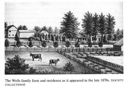
the township-Taylors, Cowles, Spencers,
Kelloggs and Wells-came
from these two towns and had
representatives in Claridon before
1818.23 Many of them intermarried either
before they left Connecticut
or within several years after they
arrived. They so dominated Claridon
that when the first township officers
were chosen in 1817 seven of the
ten were from these families. Together
they comprised 20 percent of
the residents in 1820.24 Mary Taylor,
writing home to her sister in
Hartland in 1821, reported visiting
several Connecticut relatives in her
new home. She noted that even fashion
was transported to the Reserve
when she "saw as much silk and
crepe gowns as I would in Hartland"
at a church meeting in Burton several
miles from Claridon.25
During the early 1820s, settlers moved
into the second and third tier
of tracts along what was to become
"middle street" in the central
portion of Claridon. First they moved east
and south on a road which
22. See U.S. Census manuscripts for
Claridon in 1870.
23. Pioneer History, 378-89.
24. Chiles Blakeslee forword to the Record
Book of the Congregational Society,
Claridon Township, Geauga County dated
March 7, 1831, located in the church archives,
Claridon, Ohio (hereafter cited as Record
Book).
25. Mary Taylor to her sister, Claridon,
Ohio, June 28, 1821, in the Lester Taylor
folder, Geauga County Historical Society, Burton, Ohio.
Land and Community 109
led south to Burton. Then, in the
mid-1820s they bought land on the
north-south "center street"
which bisects the township. Rarely did
they purchase in the eastern tier.
These new immigrants began to create
local institutions. Mary
Taylor and her husband joined other
families in a Congregational
group. At first, members shared a
minister with nearby Burton. In 1827
they began the process of forming a
separate church when they created
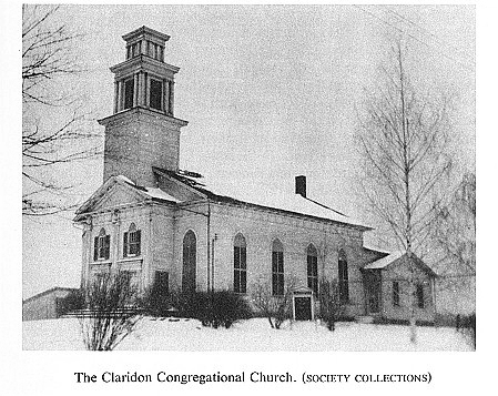
the Claridon Congregational Society. Its
officers were selected over-
whelmingly from the founding families.26
Two years later a revival
swelled the number of society members.
In response, the group moved
its meetings from the houses along west
street to a larger building, a
schoolhouse built at the crossroads in
the center of the township.
Finally, in 1831 a church building was
constructed there.27
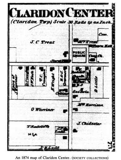
At the crossroads, on land donated by a
church member, a township
square took form modeled on New England
town squares of the late
colonial period.28 Slowly
other structures, including a meeting hall,
several shops, and another church, were
added. As early as the
mid-1830s, then, much of the township
was a developing community of
like inhabitants.
While that process was running its
course, another process was
beginning. From the mid-1820s onward
development moved away from
the center and western portions of the
township. A meager start was
made in 1816 when Lot Hathaway and
Holder Chace purchased land in
the eastern portion within the Erie
Company tract. Ten years later this
area began to prosper, in part because a
state road which ran from
Warren on the southeastern edge of the
Reserve north to Painesville on
the shores of Lake Erie cut through it
on a north-south axis.29
This eastern section was different from
the older portions of Claridon
in several important ways. Many of the
first settlers were not from
Hartland or New Hartford. Chace and
Hathaway, for example, were
from Freetown, Massachusetts, and
neither joined the Congregational
church.30 Nathaniel Mastick,
who arrived from Vermont, and other
26. Record Book, passim.
27. Pioneer History, 401-02.
28. D.W. Meinig, "Symbolic
Landscapes: Some Idealizations of American Commu-
nities" in D.W. Meinig, ed., The
Interpretation of Ordinary Landscapes: Geographical
Essays, (New York, 1979), 165-66 (hereafter cited as Meinig,
"Landscapes"). See also
Chapman, Cleveland, 1-35.
29. The road appears on land maps as
early as 1830 and on the first atlas of 1857. For
the land maps see those located in the
County Recorder's Office in Chardon. For the
atlas see Map of Geauga and Lake
Counties from Surveys and County Records
(Philadelphia, 1857).
30. C.V. Chace, Genealogical Record
of the Chace and Hathaway Families from
1630 to 1900 (Ashtabula, Ohio, 1900), 9, 29.
110 OHIO HISTORY
new settlers constituted a second
migration. Many arrived in the late
1820s and early 1830s, more often from
New York and Vermont rather
than Connecticut. Quite possibly many of
these newcomers felt left out
of local society which was already
partially formed. In any case, few
joined the Congregational church. Some
probably became members of
the Methodist society formed in the mid
1820s. Its ranks increased
sufficiently enough by the late 1830s
that it built a church across the
square from the Congregational church.
The new migrants, many of
whom were or became members of this
church, also began to inter-
marry within the confines of the eastern
third of Claridon.
These emerging sections, or perhaps
neighborhoods, were further
differentiated in the 1840s and 1850s.
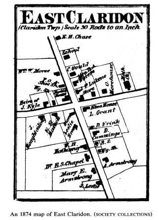
Beginning in 1840 a hamlet began
to develop in the eastern portion at the
intersection of the state road
and a smaller east-west road which
divided the township in half. Over
the next thirty years this concentration
of commercial and craft
enterprises became the hamlet of East
Claridon and gradually eclipsed
Claridon Center in terms of number of
stores and shops. It housed the
area's only hotel, first tavern, and
drygoods and hardware stores. East
Claridon differed significantly from the
square called Claridon Center.
Like most new nineteenth century towns,
it focused not on institutions
but on business and commerce.31 Its
people were different, too. A
study of the eighty-four inhabitants who
owned land in East Claridon
from 1840 to 1870 reveals that only
three were ever members of the
Congregational church.32 Claridon
Center, on the other hand, was
overwhelmingly peopled by
Congregationalists. Here is evidence of a
significant socio-geographical
differentiation in Claridon township.
Fortunately, it is possible to confirm
this separation in the late 1860s.
The Methodist church located in Claridon
Center since the late 1830s
decided to move. Not surprisingly, the
congregation and its building
moved to East Claridon in 1867.
Surviving sources attest to the virtual
bifurcation of Claridon which this
relocation confirmed. Of those who
owned land in the eastern third of the
township, fully three-quarters
were from the church. Moreover, no
Methodist lived in the middle or
western portion of the township.33 The
hamlet of East Claridon
likewise was virtually all Methodist.
31. See Schlereth, "New England
Presence," 134; Meinig, "Landscapes," 168-69.
32. Twenty tax duplicates were used to
trace land ownership patterns. Fortunately,
the original surveyor's lot designations
were kept throughout much of the period and
could be combined with maps of land
ownership which were redrawn for the conve-
nience of the county recorder at
approximately ten-year intervals. All located in Geauga
County Recorder's Office, Chardon, Ohio.
33. The original lists were graciously
lent to me by Mrs. Michael Pitorak, a member
of the Methodist Church of East
Claridon, Ohio. The lists were compared with maps, tax
|
Land and Community 111 |
|
|
|
It is no wonder then that, after thirty years of making the trip from their apparently homogeneous Methodist neighborhood to the town- ship center, the Methodists decided to break the superficial cohesive- ness of the town square. They literally brought their church and their community together. The church could have stayed in the town square, but church attendance was tied to neighborhood cohesiveness and a compatible social network. It was moved to join an existing community in East Claridon. Further confirmation of this separation comes from a Congregational church list of early 1867 which identified streets in the township for specific church leaders to canvas during a week of prayer. West, middle, and center streets, all north-south roads, had four persons each, and there were two for the east-west road; but no one was selected from the eastern third of the township along the state road in Methodist territory.34
duplicates, and lists of Congregational church members. 34. Records of the Congregational Church of Claridon, Ohio, 1866-1875, January 6, 1867 (hereafter cited as Records of the Congregational Church), located in the church archives, Claridon, Ohio. |
112 OHIO HISTORY
Furthermore, the nativity of Methodists
confirms a distinction
already suggested. They were newer
migrants (one-third were born in
New York) and were less likely to be
native Ohioans (29 percent) than
the township in general (49 percent).
Unlike Congregational church
members, 95 percent of whom were born
either in Ohio or Connecticut,
only 45 percent of Methodists were born
in either state.35 A compari-
son of occupations of the two groups
shows that fully half of the
Methodists were not employed as farmers
but made up much of the
skilled and service work force in the
area. Congregationalists, on the
other hand, were three-quarters farmers.
While still part of the rural
economy, many Methodists worked in East
Claridon where they were
more easily linked to the local and
regional business network. This
orientation continued when in the early
1870s a railroad was built along
the eastern side of the state road close
to East Claridon and the
Methodist church.36
Although Methodists were committed to
business, they were not as
wealthy as the Congregationalists. An
1853 tax assessment valued the
Methodist church building at $675, while
the Congregational building
was listed at $1200.37 The
disparity is also reflected in personal assets.
Methodists averaged $5,400 of personal
and real property in 1870 while
Congregationalists averaged over one
thousand dollars more.
Therefore, according to these records,
below the level of the
township a set of distinctions served to
differentiate Claridon. The
township contained two sections settled
at different times by people of
different religious commitments who had
different levels of wealth. In
fact, the distinctions were in some ways
the equivalent of a wall which
separated neighborhoods and perhaps even
communities. This thesis is
further supported by an impressionistic
study of the 325 marriages
recorded for the township from 1825-1869
which indicates that few
local couples included partners from
both sections.38
It would be a mistake to think that
these patterns created insur-
mountable obstacles to communication
and to all forms of institutional
interaction. Township officers by the
1830s included at least one or two
members from East Claridon, and the
sharing of political offices
35. A complete list of members compiled
in 1871 was used. See Records of the
Congregational Church.
36. Pioneer History, 410-15, and
town record books located in the Township Hall,
Claridon, Ohio.
37. See Tax Duplicate for 1853, Geauga
County Public Library, Chardon, Ohio.
38. A list of marriage license
applications from Claridon was used. The applications
are located in the Probate Court Records
in a separate volume at the Geauga County
Court, Chardon, Ohio.
Land and Community 113
continued into the 1870s.
Several farmers' clubs attracted members
from both areas as well. But other
social organizations formed in
Claridon reflected the differences. For
instance, there were separate
temperance organizations, and a chapter
of the Independent Order of
Odd Fellows formed in 1850 was
exclusively an East Claridon group.39
Consequently, while the two groups did
cooperate in some institutions,
the separation seems to be an important
dynamic in Claridon.
IV. Social Contact and Neighborhood
Context
The preceding analysis of geographical
and institutional separation is
somewhat limited because the records
which preserve these associa-
tions often list only membership,
ownership, or tax status and do not
reveal the daily activities of
residents. Fortunately, four detailed
personal diaries survive for Claridon
which help disclose the nature
and extent of local social networks and
reveal the degree of contact
which occurred within and between the
sections of Claridon.40 Also
fortunately, the diarists who are in
their 20s and 30s are socially active.
One, Clinton Goodwin, was a young
married farmer, and the other
three-Elnora Spencer, Lectrus Newell,
and Mary Taylor-were young
unmarried adults in their early
twenties. Their diaries help determine
the nature of Claridon society and
whether the differences noted above
merely happened on Sunday at church, at
meetings of some voluntary
organizations, or were an important part
of community social networks
as the previous discussion implies.
The diaries do have several limitations.
First, they are concentrated
in the period from 1855 to 1867 when
the community was well formed
and had reached its geographical and
population limits. Second,
unfortunately, all of the diarists live
in the central and western portions
of Claridon and were either members of
the Congregational church or
attended services there. Therefore, only
this viewpoint is available to
describe and analyze the social,
economic, and spatial context of
Claridon.
The diarists had very busy social lives.
Regardless of the time of
year, an extensive system of interaction
is evident. Nearly everyday
39. Pioneer History, 411-13; History
ofGeauga, 170-72. From 1839 until at least 1860
there was a Mother's Club in Claridon
which was made up of Congregationalists
exclusively. In the 1840s the club
included eighteen mothers and fifty-two children,
mostly from the Center area. See
hand-written history citing the original record book,
Claridon folder, Geauga County
Historical Society, Burton, Ohio.
40. Jeanette Grosvenor had copies of all
of these in her collections. I wish to thank
Mrs. Virginia Hyde and Mrs. Elnora Zepp
for allowing me to use these documents.
114 OHIO HISTORY
someone visited them or they visited
others. Typically, every other day
they left their farms. Seldom did they
visit East Claridon or "call" on
Methodists. Approximately one-fifth of
their trips took them beyond
the township.41 Chardon, the county seat
located several miles to the
northwest, attracted them because of its
official role as keeper of
county records, its political meetings,
and its businesses which were
more extensive than local ones.
Occasionally a special event attracted
their attention, such as the trial
Elnora Spencer and her friend and
neighbor, Maria Allen, attended in
Chardon on March 9, 1858. Spencer
noted, "we got a good seat in front
of the jury & heard Mr. Riddles plea
against Mr. Cole he sat most of the time
with his handkerchief over his
eyes."42
Relatives, friends, businesses, and
church activities drew them to
the neighboring townships of Huntsburg,
Hamden, Burton, Middlefield,
and Munson. Four young members of the
Taylor family journeyed to a
Musical Association probably attended by
Congregationalists in
Huntsburg on October 28, 1856.43
Mary Taylor, who was twenty-five,
acknowledged her difficulty fitting into
the social context because of
her age. She noted that some "young
people had gone to Burton this
eve. I do not feel so lonely & sad
... nevertheless it is not very pleasant
to think ones self has grown out of
society and is to be left alone Alas
I am so."44 Age was
only one reason for her feelings. Another was the
mobility of her contemporaries. While
she had remained in Claridon
with her parents, she found few
"out of the family that I care to visit
with. My School Mates are all
West."45
Elnora Spencer was much more positive
and active. She recorded a
trip to a nearby natural attraction,
Nelson's Ledge, with a group of ten
friends. Most of them were from center
street and four were Taylors,
but Emily Ensign, probably a school
friend, was part of the group. She
was unusual since she lived in East
Claridon. Of the individuals
mentioned and identifiable in these
ventures outside Claridon, fewer
than 5 percent were East Claridonites.46
41. An analysis of each diary indicates
that Clinton Goodwin took 21 percent of his
trips out of the township. The
percentages for the other diarists were Lectrus Newell 15
percent, Elnora Spencer 15 percent, and
Mary Taylor 10 percent.
42. Elnora Spencer, Diary, March
9, 1858.
43. No entry in any diary which mentions
those present at the various extra-township
activities lists Methodists. It could be
that they were simply not in the sphere of friends
of the diarists, but this seems
unlikely.
44. Mary Taylor, Diary, December
12, 1855.
45. Mary Taylor, Diary, October
2, 1856.
46. Elnora Spencer, Diary, August
25, 1858.
|
Land and Community 115 |
|
|
|
About 80 percent of the time the diarists moved within Claridon, "the land of steady habits," as Lec Newell described it when he returned home from a trip to Rochester, New York.47 Here they participated in vital but limited spheres of activities. Newell lamented his lack of companionship one rare evening by noting "no one been here ... Oh, how lonesome. Neither have I been away to enjoy what I often do."48 Typically, he saw friends daily but rarely those from East Claridon. Several social conventions resulted in visits to and from family and friends. Teas, a regular activity in these households, created a social atmosphere for local residents and for people passing through. Some-
47. Lectrus Newell, Diary, October 20, 1856. 48. Lectrus Newell, Diary, January 24, 1858. |
116 OHIO HISTORY
times young people visited each other in
groups, as Lec Newell did
with four friends in January, 1858.49 A
month later Elnora Spencer
recorded an exceptionally large
gathering in the afternoon at which her
family entertained "a party of
relatives twenty-four to tea."50 Of the
several hundred teas listed in the
diaries, only two included Method-
ists. Dinner or overnight guests also
appeared at least once a week. A
busy but typical round of visits to the
Spencers on June 21, 1861,
included a dinner stopover by six
couples who lived either along center
street or on west street in the southern
portion. Another diarist,
Clinton Goodwin, said he "took
supper at [Laroyal Taylor's] with the
rest of the Taylor family" on
December 25, 1867.51 Typically, family
and close friends made up the bulk of
these exchanges.
Parents and children often had different
activities on the same
evening, such as when Newell's parents
went to "Deacon Treat's to
party while I was at N. Treat's spending
the PM in singing and chatting
etc."52 The nature of
local neighborhoods is suggested by Elnora's
comments that her brother went "to
the meeting at the center. Parents
gone up street" on the evening of
March 26, 1858.53
The social life of adults in Claridon
can be suggested by Clinton
Goodwin's activities during the third
week of October, 1867. All week
he spent his days harvesting corn and
potatoes, but his evenings were
filled with relatives and neighbors. On
Sunday his young brother-in-law
came to visit him after much of the day
was spent at church. On
Wednesday he went to his father-in-law's
to eat peaches, and the next
day his father and mother visited him at
his farm. Friday "Mrs. Andrus
and 4 neighbors [were] visiting,"
and on Saturday a friend of his who
lived near the Center came to his farm.54
Apparently, adults often went
visiting in groups. Goodwin went with
his uncles and their wives to
visit on "street south of
Wells" where they stopped at two places.55
There is no indication that any of
Goodwin's rounds ever included East
Claridon residents.
Elnora and Lectrus did, on occasion,
interact socially with East
Claridon people, however. On July 13,
1861, Elnora Spencer went to
the Claridon Center with her father, but
later she continued east on the
49. Lectrus Newell, Diary, January
21, 1858.
50. Elnora Spencer, Diary, February
22, 1858.
51. Elnora Spencer, Diary, June
21, 1861; Clinton Goodwin, Diary, December 25,
1867.
52. Lectrus Newell, Diary, January
29, 1858.
53. Elnora Spencer, Diary, March
26, 1858.
54. Clinton Goodwin, Diary, October 14-October 20, 1867.
55. Clinton Goodwin, Diary, January
10, 1867.
|
Land and Community 117 |
|
|
|
center road to East Claridon where she uncharacteristically "called" on two Methodist families, the Lukens and the Armstrongs. We can only speculate on the reason for these visits because while they are unusual they are not explained.56 Further indications of a more complicated social picture were the visits that Lec Newell made to his uncle, a Methodist resident of East
56. Elnora Spencer, Diary, July 13, 1861. |
118 OHIO HISTORY
Claridon. Probably because of this
family connection, he attended a
gathering at Wilmot's (a
Congregationalist) on center street on March
7, 1858, with J.C. Hathaway (a
Methodist).57 Apparently, these
"mixed" social gatherings
happened occasionally in Claridon, but the
other diarists do not record similar
gatherings, and Newell moved
between the groups more easily than
others because of his family
connections with both Methodists and Congregationalists.
All diarists were consistently drawn to
Claridon Center but rarely to
East Claridon. At the Center the
Congregational church and, in the
mid-1850s, an agricultural hall were
sites for Sunday services and for
numerous meetings and "select"
schools. Clinton Goodwin, who was
a deacon during 1867 and 1868, missed
only four Sunday services
during the two years. His younger
counterparts were nearly as diligent,
although they were occasionally
dissuaded by the weather or sickness.
Mary Taylor attended three times a month
during 1855 and 1856, for
instance. She also went to the hall at
the Center to donation parties for
the minister and to a musical concert.
Lectrus and Elnora attended
singing school, which often attracted
Congregationalists from sur-
rounding townships. Perhaps Methodists
also attended, but none are
specifically mentioned.
Elnora recorded another social and
religious separation in her diary.
She noted on May 19, 1858, that she
heard the bell in the Congrega-
tional church toll because two people
died.58 She attended the funeral
of the deceased Congregationalist but
not of the Methodist, a Hathaway
from East Claridon.
Socially, then, the diarists tended to
stay among family, friends and
neighbors within Claridon. Economically,
they were attracted to East
Claridon for its mills, stores, and
meeting rooms. Goodwin "went to E
Claridon and got flour etc for which I
owe Mastick 4 and Lukens 2" on
July 12, 1867. A year later he went for
a hog.59 While he rarely visited
in East Claridon, he did trade there. On
the other hand, he went to
Chardon to take hides for tanning and he
also went farther afield for
more specialized items such as a carpet
or a stove which he found in
Painesville.60 Lec Newell
went to East Claridon fairly often because
his uncle, T.W. Ensign, was a hotel
keeper there. In fact, J.P. Luken,
a Methodist store owner in East
Claridon, asked him to "live in the
57. Lectrus Newell, Diary, March
7, 1858.
58. Elnora Spencer, Diary, May
19, 1858.
59. Clinton Goodwin, Diary, June
22, 1868, July 12, 1868, November 23, 1868.
60. Clinton Goodwin, Diary, December
17, 1867, November 1, 1867.
Land and Community 119
store for a year or two." Lec
recorded, he "did not give him a definite
reply."61 Presumably,
this job offer shows that the lines between the
two segments of the township were not
impenetrable.
Claridon Center also attracted visits
for business and craft. Both
Goodwin and Newell went to the center to
have wooden items
repaired.62 The blacksmiths,
milliners, and the social function of the
post office undoubtedly provided time
for economic and social trans-
fers. Diarists who often say that they
"went to the center" probably
mean they went to pick up mail,
"trade," and socialize. They never
report they "went to East
Claridon."
The reasons for this are clear. With few
exceptions the diarists
remained among family, intimate
neighbors, and friends within the
north-south streets of Claridon. They
often stayed within their neigh-
borhood. Plotting the distance traveled
by the diarists suggests that
most of the time they were in Claridon
they stayed within two miles of
their farms. Clinton Goodwin was
typical. Goodwin lived north of the
Center on "center street," and
was within two miles of both the Center
and East Claridon. He traveled north and
south on the center road
almost exclusively when visiting or
doing business within the town-
ship, and he sometimes worked for or
with neighbors or with his family
who lived within one mile of his farm.
When he ventured beyond these
bounds, it was generally to visit
family, specifically his father-in-law.
He went weekly to the center to the
Congregational church and
biweekly for business. In contrast, he
went to East Claridon rarely, and
then to the stores or meeting rooms
there rather than to visit.63
Goodwin, then, rarely interacted with
Methodists or with anyone along
the state road. He stayed within his
neighborhood and within his
religious group almost exclusively. On
February 12, 1868, he acknowl-
edged that he was going to another
neighborhood when he recorded he
had attended a "meeting on Spencer
Street for Young folks." "Spencer
Street" was a Congregationalist
neighborhood along the west road
where many members of the Spencer
family, including Elnora's family,
lived.64
The spatial relationships of the younger
diarists confirm these
definitions. Elnora Spencer limited most
of her contact to her street,
61. Lectrus Newell, Diary, January
25, 1858.
62. See Clinton Goodwin, Diary, February
11, 1868, and March 3, 1868.
63. Clinton Goodwin, Diary, July
12, 1868, and November 23, 1868.
64. The preceding analysis is the result
of mapping all the known individuals and
locations given in the diary, which was
possible for approximately 80 percent of the
entries. Similar procedures were
followed to determine the spatial relationships of each
of the other diarists.
120 OHIO HISTORY
the Center and the road extending north
of it. While she did venture
south in the western portion and
occasionally a little east, her contacts
within the township were limited. She
often left her house in the
company of her suitor, Lec Newell, who
lived north of Claridon
Center. She had very little contact with
East Claridon even though she
appeared to know residents there. Lec
Newell lived on his father's
farm which was just north of Claridon
Center and, like Goodwin, had
most of his contacts on the center road.
Newell rarely ventured west
unless it was to Elnora's. He often
worked with neighbors and relatives
who lived on adjacent farms. He did visit
his relatives in East Claridon,
but most of his social life revolved
around singing activities and a series
of parties held for his Congregational
peers.65 The third young adult,
Mary Taylor, had very limited spatial
and social contacts. She lived on
Middle street just west of the Center
where most of her spatial and
social interaction took place. While she
constantly noted that her
parents and siblings visited others, she
was reclusive; although she
enjoyed visits by others, she rarely
went out herself. During 1856 she
made only fifteen visits, many of which
were to family or events
connected with church.66 Typical
of all diarists, she mentioned only
two interactions with East Claridon
residents and did not go to the
hamlet itself.
Therefore, socially, economically, and
spatially the four diaries
demonstrate that the division within
Claridon township was a vital part
of daily life. They also reveal several
overlapping spheres of interac-
tion. The first and smallest sphere
includes the farm, intimate family,
and neighborhood which take up much of
the daily activities. Second,
a larger sphere used less often was
defined by church-related activities
and more extensive family contacts which
drew residents farther from
their farms and sometimes into contact
with those beyond the town-
ship. An even larger sphere of economic,
political and social ties
occasionally involved them with
residents from other groups, including
Methodists. One can safely speculate
that diaries written by Method-
ists in East Claridon would include
these same spheres and include few
contacts with Congregationalists.
V. Conclusion
This analysis of Claridon township has
shown that the nature and
parameters of social change as measured
by social statistics do not
65. Lectrus Newell, Diary, January
29, 1858, February 26, 1858.
66. She provided the summary information
in the diary. See Mary Taylor, Diary,
December 30, 1856.
Land and Community 121
always suggest the complexity of social
life itself. Despite data which
indicate that a homogeneous, stable
community had emerged in
Claridon by the mid-nineteenth century,
migratory patterns created
differences in settlement areas and
social contacts which in some real
ways divided the township physically
and socially. As early as 1840
two groups appeared, and later
developments mirrored in the physical
evolution of Claridon Center and East
Claridon kept them separate in
some ways. By the 1850s and 1860s,
spatial and social interaction
continued to preserve the distinction
and even perpetuate it within the
limited spheres of Claridon social life.
The evolution of social contacts and
social life on the Trans-
Appalachian frontier suggests that the
Yankee heritage, while still
firmly rooted in Protestant
Christianity, created separate social and
religious contexts which in part
determined the social life of commu-
nities as they matured.