Ohio History Journal
OHIO SURVEYS FROM THE AIR
By ALFRED
J. WRIGHT
Many Ohioans have been interested in
studying the evolution-
ary aspects of today's landscapes. Very
likely many more will
think along these lines during the year,
marked as it is by the
sesquicentennial celebration of the
founding of Ohio. There
have recently come into the possession
of the State Archaeological
and Historical Society some air
photographs of one aspect of this
evolutionary thought.
Through the good offices of the State
director of aeronautics
and the Materiel Division of the United
States Army Air Corps,
Wright Field, Dayton, these photographs
were taken with a view
toward establishing the persistence of
some original survey lines
in the present-day landscape. The use of
the airplane in making
aerial studies has met with considerable
success in the exhaustive
tests to which the method was put in the
Muskingum Conservancy
Project and in numerous archaeological
and historical studies.
Major Fred Smith, formerly director of
aeronautics, located
these original survey lines on contour
sheets of the Ohio Coopera-
tive Topographic Survey. Thus oriented,
he photographed virtu-
ally all of the Ludlow and Roberts
Lines, and portions of the
Greenville Treaty Line. In the
accompanying photographs por-
tions of these original surveys are
indicated, generally in the center
of the view. They are necessarily
oblique photographs, taken at
an elevation of 12,000 feet. Distortion
prevents accurate scaling
of all but one of them--Fig. 5.
In a previous study, the writer ventured
some observations
relative to the influence of original
surveys upon Ohio town pat-
terns.1 In the meantime these
photographs have been made avail-
able to the end that persistence of
these lines may be observed in
rural as well as urban areas.
1 "Ohio Town Patterns," Geographical
Review (New York), XXVII (1937),
615-24.
(53)
54 OHIO
ARCHAEOLOGICAL AND HISTORICAL QUARTERLY
The consequences of Ohio's situation
with respect to the
prevailing paths of continental
settlement have been the subject
of much study and comment; in
particular, the rapidity with which
Ohio increased in population, after a
somewhat tardy period of
appropriation and settlement. Contiguity
to the Great Lakes or to
the Ohio River has not necessarily meant
that their influence upon
the peopling of a state would be marked.
In the instance of
Ohio, however, the influence of these
two water boundaries has
been unmistakable. In the apportionment
of lands and in the suc-
cessive economies developed there, the
influence of these environ-
mental features has been pronounced.
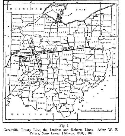
Greenville Treaty Line
Chief among Ohio surveys is the
Greenville Treaty Line.
With but two interruptions, it marks the
division between the orig-
inal surveys of southern and eastern
Ohio and the tardily-settled
northwestern portion of the State. The
treaty with the Indians
which inaugurated this line was
subsequent to the establishment of
the Virginia Bounty or Military
District. The Virginia District,
therefore, constitutes one of the two
interruptions referred to
above. Having agreed to this line as
marking the boundary of the
land to which the Indians were conceded
to have superior title,
no surveys were made to the north and
west of this line until
after subsequent treaties extinguished
Indian title to the northern
portion of the State. This fact explains
the other interruption of
the Treaty Line, between Lake Erie and
the town of Bolivar on
the Tuscarawas River (Fig. 1).
The Greenville Line followed the
Cuyahoga River to its por-
tage with the Tuscarawas, and thence
along the latter stream to
a point where an old Indian trail
crossed the river, marked ap-
proximately by the town of Bolivar. Thus
these two portions
of the Greenville Line were never
observed in surveying minor
civil subdivisions and are, therefore,
not a part of the present land-
scape.
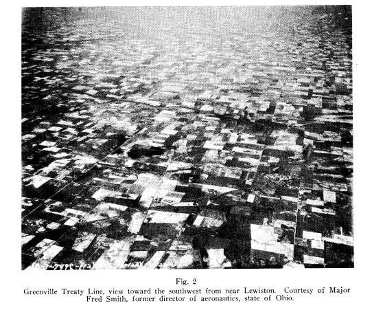
Fig. 2 (3-749C) is a view toward the
southwest along the
Greenville Treaty Line. In the left
background the Great Miami
River may be discerned. This was
photographed in May before
|
OHIO SURVEYS FROM THE AIR: WRIGHT 55 the crops had masked the pattern of fields and roads. The old Treaty Line may be seen running entirely across the photograph, |
|
|
|
from top to bottom, almost through the center of the view. There are places where its continuity is interrupted, but for the most part its persistence is remarkable in view of the century and a half which has elapsed since it was run. The town of Lewiston in Logan County appears in the right foreground. This portion of the line is not within the Virginia Military District, so the eccentricity of orientation of roads and lot lines |
56 OHIO ARCHAEOLOGICAL AND HISTORICAL QUARTERLY
peculiar to the District is not shown on this view (See Fig. 5,
1-749H). Only a minor portion of the line is marked by high-
ways, and no villages appear to be localized by it. This is not
illogical in view of the fact that this boundary at no time sepa-
rated areas that were currently open to federal sale, and as an
Indian territorial limit, it could scarcely have invited white man's
population groupings.
Ludlow and Roberts Lines
The boundaries of the Virginia Military District were the
Scioto, Little Miami, and Ohio rivers. This necessitated a line
being drawn from the headwaters of the Scioto south to those
of the Little Miami. To establish this boundary, two surveys
were run: the earlier Ludlow and the later Roberts lines, lying
about four miles apart where they crossed the Greenville Line.
After considerable discussion, Congress in 1818 used both lines
in determining this limit to the Virginia District. South of the
Treaty Line the survey of Ludlow was accepted, while north of
it the Roberts Line was held to be official. Disputed lines, such
as these were for a time, might lead to interesting lot lines and
minor civil subdivisions, consequently Smith photographed all
of them. The limits imposed by publication preclude our showing
more than one view of each survey, but these will give an adequate
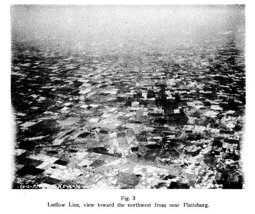
idea of the persistence of these lines. Fig. 3 (2-750E) is a view
toward the northwest along the Ludlow Line. This was photo-
graphed from near Plattsburg in Clark County, with the survey
cutting the center of the picture from top to bottom. The old
Cumberland (National) Road may be seen intersecting the Lud-
low Line in the center of the view. The town of South Vienna
lies just west of the intersection. This was photographed dur-
ing May and the survey line appears to be quite as distinct as in
the instance of the Greenville Treaty Line. Inasmuch as this is a
portion of the Virginia District boundary, there should be some
indication of the eccentricity of orientation that we associate
with the older survey. (See Fig. 5.) The reader will have little
difficulty in observing abundant evidence of the contrast in field
pattern and road orientation; to the right they are not oriented
OHIO SURVEYS FROM THE AIR: WRIGHT 57
with the cardinal points of the compass, while to the left they
are. Account must be taken of the oblique nature of the view,
but the contrast is unmistakable.
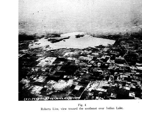
Fig. 4 (1-749B) is a view toward the southeast along the
Roberts Line. The old survey appears on both sides of Indian
Lake, but the view is foreshortened on account of the poor visi-
bility south of the lake. As a feature of the pattern of occupance,
this, like the other two original surveys, persists in the present
scheme of holdings. Other air photographs of this survey reveal
much the same degree of persistence south of the lake. In all of
them we see striking evidence of the longevity of original surveys
in land holdings.
From the air some account must be taken of the contrasting
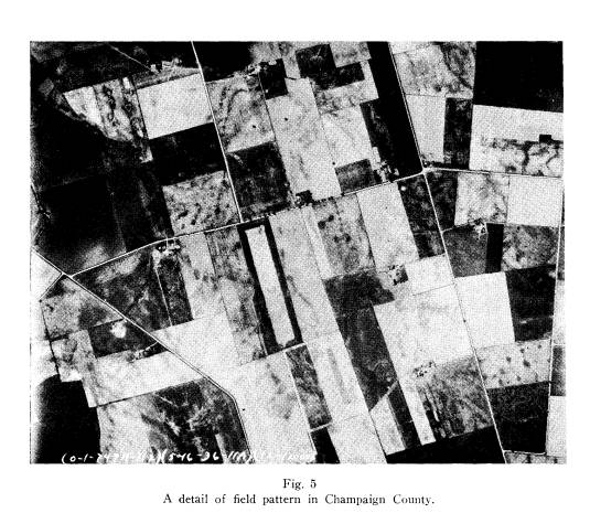
systems within and without the Virginia District: Fig. 5 is a
view of the Ludlow Line in Champaign County, sections 7 and
12, Salem township. This low altitude and nearly vertical shot
of the field and road pattern on both sides of the Virginia District
boundary reveal a form sufficiently common as to warrant some
emphasis. The north-south road just to the west of the Ludlow
Line is not in the Virginia District, and follows a section line; in
the Virginia District there are no section lines. It is common for
roads to orient the field pattern, so this sample may be taken as
typical throughout the adjacent areas. In towns and cities where
there is apt to be a more active change in lot lines, these original
surveys are not so persistent, but even here there is ample evi-
dence of these regional contrasts.
