Ohio History Journal
SANDY AND BEAVER CANAL1
By
W. H. VAN
FOSSAN
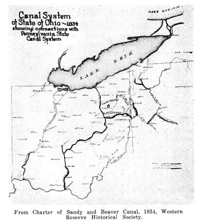
As a part of the Ohio system of canals
the Sandy and Beaver
was a branch from Bolivar, Tuscarawas
County, to Smiths Ferry
on the Ohio River forty miles below
Pittsburgh. Bolivar was its
junction point with the Ohio and Erie
Canal which extended from
Cleveland to Portsmouth. Its promoters
were planning a more
direct route to join Ohio and Lake Erie
with the Pennsylvania
canals between Philadelphia and
Pittsburgh.
The practicability of the project was
investigated in 18262
and on January 11, 1828, the Ohio
legislature granted a charter
which was amended and renewed in 1834.
The directors were
Benjamin Hanna, the grandfather of
Marcus Hanna, who was
elected as president, David Begges,
Horace Potter, George Mc-
Cook, James Robertson, Joseph Richardson
and Elderkin Potter.
These seven represented Columbiana
County. There were also
four from Stark County: William
Christman, William Henry,
William Reynolds and Jacob Hostetter.
Tuscarawas had Christian
Deardoff and Henry Lepper.
The charter of 1834 and the reports of
the engravers were
printed at New Lisbon (now Lisbon) by
Joseph Cable November,
1834 -- 40 pages with a map.3 In
a letter written by Hanna in
his office at New Lisbon, October 4,
1834, he commended the
legislature for the liberal terms it had
granted. The company was
given the privilege to collect the tolls
for seven years, the only
tolls due the State were on freight
transported not less than
twenty miles. The matter of the canal
and its charter also came
before the U. S. House of
Representatives. A resolution was
1 In the Library of Congress a few years
ago the writer ran across an old document
containing important information on the
Sandy and Beaver Canal. He was greatly in-
terested in his discovery, for nearly
all his life he had lived where he had the oppor-
tunity to learn many things about it.
Out of the material he has gathered from
various sources he has written this
brief sketch on the building and operation of this
old waterway.
2 Ohio
Canal Commissioners, "Annual Report," Ohio Senate, Journal, 1826/27,
p. 126.
3 A
copy may be seen in the Western Reserve Historical Society Library, Cleveland.
165
|
166 OHIO ARCHAELOGICAL AND HISTORICAL QUARTERLY passed to sell unsold public land in Ohio and invest the money received in stock of the company. A contract for work was to be let after the first installment of stock was paid. |
|
|
|
Two hundred thousand dollars was subscribed along the line and was promptly paid. Books were opened in Pittsburgh and Philadelphia for subscription. In a letter, dated at New Lisbon, Oct. 14, 1834, President Hanna wrote, "The board [of directors] earnestly invite the attention of the citizens of [Pittsburgh and |
SANDY AND BEAVER CANAL 167
Philadelphia] . . . to the . . . charter
and reports [of the engi-
neers], and respectfully solicit their
aid, by the liberal subscription
of stock, in the early completion of a
project which promises
generous terms to the capitalist, and
inestimable benefits to the
public."4
For the purposes of construction the
canal was cut into three
divisions: Middle, Western, and Eastern.
The Middle Division
reached from the Middle Beaver, nearly
two miles above New
Lisbon across the watershed to a point
on Sandy Creek two miles
beyond Hanover, a distance of twelve
miles. Guilford (Gill's
Ford) and Dungannon were in this
section. The cost as esti-
mated by the engineers was $287,000 or
$20,000 per mile. The
following figures show the cost of the
West Fork reservoir, now
Guilford Lake: 68,000 cu. yd. embankment $13,600; 500 linear
feet of pipe, $2,700; 672 perches
of stone for wall $1,300; 200
perches stone for wall, $600; sluice
gates $1000. A total of
$19,200.
A visit to this lake, the building of
which was financed by the
State, always calls up old memories. The
lake farm was the
writer's home during the closing years
of the Civil War. A maple
grove stood along that part of the lake
now occupied by cottages.
The season for gathering the sap and
boiling it down in big ket-
tles into syrup and sugar he remembers
very clearly, then being
in his eighth year. Perhaps his most
interesting recollection was
to watch the large droves of sheep and
cattle before his door on
the State highway en route to eastern
markets. A necessity be-
fore the days of railroads, the practice
had not been discontinued
entirely. The part of the lake just
above the embankment was a
big creek bottom containing fifty acres
of rich pasture. The
writer's father frequently rented it for
the night where the stock
would find needed rest as well as
abundance of grass and water.
In these droves there were as many as
eight hundred to a thousand
or more sheep or five hundred head of
cattle.
A smaller reservoir, that of Cold Run,
was built east of Guil-
ford. It was fed by the head waters of
that stream. The esti-
mated cost was $11,700.
4 U. S., 23 Cong., 2 Sess., Doc.
No. 50 (Washington, 1834), 27 pages with map.
|
168 OHIO ARCHAEOLOGICAL AND HISTORICAL QUARTERLY Another important feature of this division was the excava- tion of two tunnels, the only canal the writer knows of in Ohio where tunneling was necessary. This had to be done to cross the |
|
|
|
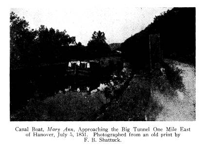
divide between Sandy Creek and West Fork. The "big tunnel" as it has always been called was just east of Hanover on the way to Dungannon. The tunnel proper was 900 yards long. With the deep cuts at both ends, its length was two and a quarter miles. The height was seventeen to eighteen feet. At the deepest point the bed of the canal was eighty feet below the summit. Shafts were put down at convenient distances apart and the blasted rock was lifted through them and spread out over the hillside. An average of about 125 men were employed working in shifts day and night from both ends. They were over three years in com- pleting it. A small village of shacks grew up near by where the workmen lived, a large percentage of whom (as indeed it was of canal diggers, generally) had recently arrived from the Emerald Isle. Far below the surface, the workmen on the tunnel made a |
SANDY AND BEAVER CANAL 169
surprising discovery in finding the
bones of a Mastodon. When
attending high school at Hanover, the
writer saw these huge relics
at the home of Morris Miller who was one
of the canal con-
tractors.
The "little tunnel" was
northeast of Dungannon and was near
to 1000 feet in length. It was arched
with stone. This was not
required in the larger one as it was cut
through solid rock. With
this tunnel and one or more locks the
canal was let down to the
level of the West Fork of Beaver three
or four miles below
Guilford.
The Western Division ran from a point
near Hanover to its
junction with the Ohio Canal at
Bolivar--33 1/2 miles. The cost
was estimated at $332,000 -- $ [10,000 a mile.
This section followed
the Sandy Valley through Minerva,
Malvern and Waynesburg to
Bolivar where Sandy Creek empties into
the Tuscarawas River
It was a comparatively level course and
free from a hill country
like that in Columbiana County which the
canal had to cross in
getting from one stream to another. A
small reservoir was built
on the farm of Peter Preston less than
two miles west of Ken-
sington -- then called Maysville. The
embankment is in sight of
U. S. Route 30, about half a mile to the
north. The writer has
no figures of its cost. A claims
committee gave Mr. Preston $200
in damages.
The Eastern Division began at the summit
above New Lis-
bon and followed Middle Beaver through
the county seat, Elk-
ton, Williamsport, Fredericktown and
then through the Little
Beaver itself into Pennsylvania and to
the Ohio at Smiths Ferry,
its terminal. It was the longest of the
three divisions -- 43 miles
Its cost was $535,000 -- $12,000 a mile.
The cost of the entire canal was $1,144,000 and its length
90 1/2 miles. In a straight
line the terminals were little more than
half that distance apart. Its many
necessary meanderings in
following the course of streams and
especially in crossing the
hilly lands of Columbiana County account
for its length. At
the surface it was 40 feet wide; at the
bottom 28. Its depth was
four feet. There were 40 locks between
Hanover (now Han-
overton) and Bolivar and 140 from Hanover to
Smiths Ferry.
170
OHIO ARCHAEOLOGICAL AND HISTORICAL QUARTERLY
Work began north of New Lisbon on land originally owned
by Gideon Hughes, who, in 1808, had
built the iron furnace and
the stone mansion now owned by the Boy
Scouts organization of
Columbiana County. It was at this
historic spot where the
ceremony of breaking ground took place,
November 24, 1834.
A large crowd had gathered there.
Elderkin Potter, a prom-
inent lawyer and a director, was the
speaker of the day. He
pictured eloquently the great future for
New Lisbon and the
county. A letter from President Hanna
was read which gave
instructions to the engineers.5 The
first shovelful of dirt was
thrown by Mr. Potter.
The work begun in 1834 was carried on
vigorously. By
1838, the funds were exhausted. Already
$1,300,000 had been
spent and only about one-half of the
canal was completed. At
that time the country was passing
through the severe panic of
1837 and work on the canal was stopped.
The legislature was
again appealed to for funds and
construction was resumed.
In 1846, the Eastern Division was
finished. The first boat
arrived at New Lisbon, October 20 in
command of Captain Dunn.
Amid wild enthusiasm a great meeting was
held at the Hanna
canal warehouse, followed by a supper
and ball at the Watson
House. The program for the day of
general rejoicing ended
with a display of fireworks.
A somewhat amusing incident occurred a
few weeks later.
which dated back to the canal jubilee.
Strange as it may seem
it is on record in the Minutes of the
Presbyterian Church, Mon-
day, December 7, 1846. It was discovered
while a sketch of the
church was in process a few years ago. A
member had been
cited to appear before this body of
elders on the charge of drunk-
enness. He confessed his guilt but
offered in defense that it
occurred on the night of the celebration
of the opening of the
canal. His confession bore the marks of
truthfulness, and with
a promise of good conduct in the future,
the charge was dropped.
The usual punishment for the offense was
suspension from the
communion table and other church
ordinances for such a time
as might be needed for the offender to
show "fruits meet for re-
5 Ibid.
SANDY AND BEAVER CANAL 171
pentance." This judicial body of
church fathers was convinced
that he was not the only one of the
Presbyterian flock who had
imbibed too freely on that hilarious
night.
Another of the packets on the Eastern
Division was named
for David Begges who was a New Lisbon
man and a director
of the canal corporation. George Ramsey
was its captain. The
warehouse just referred to was of a type
similar to others built
on the banks of the canal at shipping
points. Some of them
were three stories. After canal days
they were occupied by pri-
vately owned stores. The writer
remembers two of these big
frame buildings at Dungannon. The one at
the west end was
known as Hagan's General Store. The
other stood just across
the canal from the grounds of the
one-room school. Unoccupied,
its windows were a target for the boys.
But the glass was all
gone before the writer's two years in
the school. Hanover also
had the same number of stores. The one
to the east was built
by J. R. and A. R. Arter. The other by
David Arter and Perry
Nicholas. The Arters used the former for
many years for dry
goods and general merchandise. It is the only one of these five
warehouses that is still standing. At
present it is occupied as
a hardware store.
The canal was opened in divisions as
each was completed.
The first boat to reach Hanover arrived
from the east, January
6, 1848.6 The night before, it had grounded just below the place
where the Lincoln Highway (U. S. Route
30) crosses West
Fork. The work on this section was not
entirely finished, but
in order to hold the charter it was
necessary that a boat be gotten
through. Morris Miller, the contractor
at Hanover, aided with
seven yoke of oxen. Along with him were
many citizens of the
town, and the band. The boat was raised
and dragged into the
channel and all went well until the big
tunnel was reached. Here
a large piece of rock had fallen into
the canal. The obstruction
removed, the boat soon reached Hanover
and was tied up at the
lower warehouse. Other boats passed
through this tunnel for a
few years; but in the dry summer of 1854
it could not be used
6 Ohio Board of Public Works,
"Special Report," Ohio Exec. Doc., 1847/48, pt. 2,
doc. 26, p. 492-3.
172
OHIO ARCHAEOLOGICAL AND HISTORICAL QUARTERLY
owing to a lack of water. The last boat
to go through was the
Hibernian which was owned by Hanover men. Though the
Middle Division had 700 acres of
reservoir there were parts of
the year when it suffered from shortage
of water. At the divide
north of New Lisbon the engineers gauged
the flow at the lowest
point and found it to be 1200 cu. ft. per
minute. Here the canal
intersected and received the water of
Middle Beaver. This was
the initial supply for the Eastern
Division. Though small, it
was larger than that of the Middle
Division.7
From another quarter the canal was about
to be given a
much harder blow. The Cleveland and
Pittsburgh Railroad was
built about 1852 and quickly took over
most of the business in
that section of the canal. Boats
continued to run for a time
between Hanover and Bolivar, but not
long. In its short career,
however, the canal had carried large
cargoes of wheat from Han-
over which was a live town of 600
people. Dr. James Robert-
son was a director, and Michael Arter
was the treasurer of the
canal company. Both were Hanover men.
The enterprise of
its people was shown by their building a
switch to the railroad
station a mile away at Kensington, then
called Maysville. It
was a crude affair. Wooden rails were
fastened to the ties and
flat bars of iron were spiked to them.
Cars were switched to
this spur and drawn by horses to and
from Hanover. A loco-
motive was too heavy to be used. It was
an easy grade and ran
parallel to the canal. A tram car was
put on for mail and pas-
sengers. The track being difficult to
keep in order it was soon torn
up and a bus was put on in place of the
car.
In the years of its inception and
building the time seemed
opportune for the Sandy and Beaver. The
population of Co-
lumbiana County had passed 40,000. Only
two counties ex-
ceeded it--Hamilton and Richland. New
Lisbon was its largest
town with 1800 people--a promising
little city. Salem had 1300
and Wellsville 800. James Bennett had
built East Liverpool's
first pottery in 1839, then a village of
600. Settlers were pour-
ing into Ohio from Pennsylvania and the
seacoast states. Many
7 W. S. Potts, "Early History of
Columbiana County," History of the Upper Ohio
Valley (Madison, Wis., 1891), II, p. 140-1.
SANDY AND BEAVER CANAL 173
were coming directly from Great Britain
and Germany. Ohio
was a wheat growing state. A group of
five counties in eastern
Ohio, known as the "backbone
counties," were famous for its
production. Columbiana and Stark were
two of them. Wheat
was the farmers' money crop and farm
housewives made much
of their bread from rye and corn rather
than from wheat. The
wheat crop was marketed over the old
State Road which entered
the State from Pennsylvania and crossed Columbiana County
through New Lisbon, Guilford, New
Alexander and westward
into Stark and to Massillon which was a
port on the Ohio Canal.
When a small boy the writer heard his
father tell of his expe-
riences when he drove one of the big
wheat wagons with its four-
horse team along this road.
The canal boatman had taken the place of
the wagoner. In
1822, the legislature had passed a resolution to build a system of
canals. Three years later, on July 4,
ground was broken for the
Ohio and Erie from Cleveland by way of
Akron, Massillon, New-
ark and Columbus to Portsmouth. In 1833,
it was completed.
A second, the Miami and Erie, from
Cincinnati to Toledo fol-
lowed. Together with several branches,
their combined length
was 813 miles. It was the greatest
engineering enterprise ever
carried out by the State. Its cost was
sixteen million dollars,
but it paid back great economic
dividends to its sponsor. For a
quarter of a century these canals were
of inestimable worth to
Ohio in enlarging its trade and
increasing its production and
population. In the beginning the State
was comparatively poor.
It had become wealthy and great.
But the prosperity of the canals was not
to last. By the early
fifties their annual reports showed a
deficit. They were feeling
the steam railroad a crushing competitor
and before the Civil
War they had practically been
supplanted. In rapidly moving
Ohio the canals were found to be too
slow. Because they were
frozen over in winter they were even
useless for months. The
business of the State had risen beyond
their capacity to handle
it. In a word, Ohio had outgrown the
canals.
As for the Sandy and Beaver it had come
too late to have
even a short and prosperous career. Like
the Western Division,
174
OHIO ARCHAEOLOGICAL AND HISTORICAL QUARTERLY
the Eastern continued to operate in a
way for a short time. The
story of the canal system was a
completed chapter in the history
of Ohio. Some short sectors of the Ohio
Canal were kept open
and did a small business after the
through traffic had ended.
The writer has some pleasant memories of
those last days of that
canal. With several friends he spent a
few weeks camping on
the banks of the Tuscarawas River and
the banks of the canal at
Zoar, that interesting and prosperous
community village of Ger-
man Separatists, two hundred of whom had
emigrated from
Wurtemberg in 1819. Bolivar
was only a few miles away. Now
dissolved, its 8000 acres and village
properties were then held in
common. A beautiful and restful spot,
the writer and his
friends had selected this place with the
trim quaint village in
sight, a bit of old world life
transplanted to Ohio. Here a sector
of the canal was still doing a small
business. It was a novel
sight to see a boat passing with a team
of mules drawing it lazily
along the towpath. Here it was that
James A. Garfield when
a fourteen-year-old lad from the Western
Reserve had tramped
the towpath as the driver of a canal
boat. At the time of the
summer outing, which was in 1882, the
death of the martyred
president, who had been assassinated the
year before, was still
fresh in the mind of every one.
As the canal days ended, the railroads
were rapidly writing
a new and far-reaching chapter in the
history of Ohio transpor-
tation. The building of the Cleveland
and Pittsburgh Railroad
has already been mentioned. About the
same time the Pennsyl-
vania Company was mapping its main line
from Pittsburgh to
Chicago. New Lisbon was on the direct
route, a live centrally-
located county seat town. Its business
men were sorely disap-
pointed over their investments in the
canal and were lukewarm
toward the new project and the terms
offered. They generally
believed that the company would not fail
to make their prosper-
ous town its first important station in
Ohio. In this they were
mistaken and New Lisbon missed its
opportunity to get this
trunkline which would have been a big
factor in its growth as
a center of trade and industry.
Many years have passed but the course of
the canal can still
SANDY AND BEAVER CANAL 175
be traced easily, though its ditch has
been obliterated in places
and most of its finely cut blocks of
native sandstone have been
torn out of locks for cellar walls and
other uses in masonry. A
hike on almost any part of it would be
worth while for the sight
of old landmarks and beautiful scenery.
Along the Sandy Valley are many places
of quiet beauty in
the villages and the fertile farms
through which the canal passes.
The canal's outstanding features,
however, are found in the rough
terrain of Columbiana County. In fact,
it was primarily a proj-
ect of this county. Tunnel Hill near
Hanover is the site of one
of its most expensive undertakings; then
there are the Guilford
and Preston reservoirs. On the divide
north of New Lisbon and
near the Rebecca iron furnace it was
found necessary to build
a line of fifteen locks in less than two
miles.8
The writer recalls a beautiful scene
along the canal with
which he was familiar in his boyhood
days, where the Lincoln
Highway intersects West Fork five or six
miles west of Lisbon.
Here was a sawmill with its race and
dam. A good place for
fishing and swimming. A covered wooden
bridge spanned the
stream at this point as the concrete
bridge does now. The breast
of the dam was close up to the bridge.
Below was Frost's, later
Roller's flour mill. Upstream on a high
elevation called Pine
Hill, stood a large clump of tall white
pines proudly overlooking
the canal and valley. It is a lovely and
long-cherished picture.
In the southern part of the county at
such places as Williams-
port, Fredericktown, Spruce Vale, and
Gaston's Mill the fine
scenery reaches its climax. Here in
scene after scene of sur-
passing beauty the canal winds among the
lofty hills and along
the deep wild gorges as it nears the
Ohio.
Among the outstanding relics still in
existence are two or
three locks that are in good condition.
One of these is near
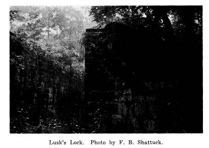
Spruce Vale. The most noted, Lusk's
Lock, is about six miles
east of Lisbon, where it is hidden in a
steep, rocky ravine of the
Middle Fork of Beaver. It is
exceptionally large, being one
hundred and two feet long, including the
abutments at each end,
8 W. F. Gilmore, A History of the Old Sandy-Beaver Canal
(Canton, O. [1937?]),
map, views, and descriptive text.
|
176 OHIO ARCHAEOLOGICAL AND HISTORICAL QUARTERLY one hundred and forty-one feet. The walls are twelve feet high and fourteen feet apart. The entire top is capped with a layer of stone which has protected it. The top is reached by a flight of thirteen steps. The lock was built in 1836 and was number eleven in those of the Eastern Division. Contractors were Lusk |
|
|
|
Lusk's Lock. Photo by F. B. Shattuck. and Maynard; E. H. Gill was head engineer. The stone giving this information was broken off and is now in the possession of Melvin Forbes of Columbiana. With the exception of this stone, the walls and buttresses are unbroken, a notable exception among the canal locks. Here also is the site of one of those small dams scattered along the entire course. All the stone is from a nearby quarry. The adjoining land, after the failure of the company, was sold to Isaac Stokesberry. It is still owned by this family, to whom must go the credit for the preservation of the lock. The present occupant is a grandson, Carl Stokesberry. The Sandy and Beaver, though a bitter failure as a business |
SANDY AND BEAVER CANAL 177
enterprise, has left us many interesting
reminders of its brief
career in the pioneer days a century
ago. The locks and other
striking relics of the canal will add a
background of historic and
even romantic interest to the State park
which may soon be made
of a large area in southeastern
Columbiana County. Such a
development would make out of the way
places accessible to the
public, and the whole section, with its
natural beauty and pioneer
story, would become an attractive
pleasure ground for a great
number of people.