Ohio History Journal
WATER HIGHWAYS AND
CARRYING PLACES.
E. L. TAYLOR, COLUMBUS.
The 2d day of May, 1497, was one of the
most eventful
for great results for good of any in
human history. On that
day, John Cabot, a Venetian by birth,
but who was then living
at the old sea-faring town of Bristol,
on the west coast of Eng-
land, with eighteen hardy British
sailors weighed anchor on the
small, but good ship
"Matthew," and passed out upon the broad
and turbulent waters of the Atlantic on
a voyage of discovery.
It is probable, but not certain, that
his son, Sebastian, accom-
panied him on this voyage. The adventure
was entirely at the
expense of Cabot. He had, however,
obtained from King Henry
VII., royal permission to carry the
British flag, and was com-
missioned to "seek out, discover
and find whatever lands, coun-
tries, regions or provinces of the
heathens or infidels, in what-
ever part of the world they may be which
before this time have
been unknown to all Christians."
Further, he was required, if he should
be so fortunate as
to return, to report at the port of
Bristol and to "take a fifth
part of the whole capital, whether in
goods or money for our
use." The return was made in the
following August, but with-
out "goods or money," and with
nothing but a vague report that
they had discovered land in the north
Atlantic, hitherto unknown
to the civilized world.
All that could be reported of the voyage
was that after
leaving the port of Bristol, the vessel
held her way to the west-
ward, and late in June they came in
sight of land, and after sailing
some leagues to the south along the
coast, they went ashore and
so were the first Europeans to set foot
on the continent of North
America. They had no thought that they
were standing upon
the shore of a great and hitherto
unknown continent, or that their
discovery of land in these far off
waters was, or would become
(356)
Water Highways and Carrying
Places. 357
of any special importance or
significance. They were not look-
ing for a new continent, but were hoping
to reach the east coast
of Asia, known in Europe since the time
of Marco Polo, as
"Cathay." Cabot did not live
to know that he had discovered
a great new continent, which was then
and had been for many
thousands of years occupied by a race or
races of savages, whose
energies had been spent in the hunt of
wild beasts and in waging
war upon each other, which wars between
savage tribes and
nations were wars of extermination in so
far as they could make
them.
CABOT.
The place of Cabot's landing has not
been definitely deter-
mined and probably never can be, but a
committee appointed by
the Royal Geographical Society of
Canada, reported in 1895,
that the weight of evidence is that it
was on Cape Breton, which
is on the extreme north east coast of
the Province of Nova
Scotia. At the place of their landing
they found no human
inhabitants, but did find snares and
devices for taking fish and
game, which were evidently designed by
human minds and
wraught out by human hands. But wherever
it was, they seem
to have unfurled and planted the British
flag and made some
kind of proclamation to the effect that
they took possession of
the land in the name of the King of
Great Britain. Nothing
could seem to be more idle or
meaningless than this proclamation
or outcry to the winds and waves of this
unknown, desolate
rock-bound coast, and yet it became in
time to be the basis of
whatever title Great Britain had to the
continent of North
America.
After Cabot, numerous explorers came to
our shores, but
they seem to have been satisfied with
coasting along the shores
with no purpose or effort to penetrate
the interior, or learn what
lay hidden behind the desolate coast
line. It was not until 1534
that the mouth of the St. Lawrence River
was discovered by
Jacques Cartier, and it was not until
the next year (1535) that
any successful attempt was made to
explore the interior of the
northern portion of the continent to
which the St. Lawrence
was the great highway.
358 Ohio Arch. and Hist.
Society Publications.
JACQUES CARTIER.
In that year (1535) Jacques Cartier, a
French navigator,
ascended the St. Lawrence to the point
of the present site of
Montreal. The great Lachine rapids
prevented further progress.
This was thirty-eight years after
Cabot's discovery of the coast,
during which time no special effort
seems to have been made
by English or other European navigators
to penetrate the interior
of the northern portion of the
continent, or to learn anything
of its nature or conditions. This
inaction was in strange con-
trast with the activity of the Spaniards
in their enterprises far-
ther to the the south. It was some
fifteen years after Cabot's
discovery that the Spaniards first saw
or set foot on the North
American continent, and yet before
Cartier's discovery of the
St. Lawrence, they had overrun and
conquered Mexico, and
Peru; and it was but four years later
that De Soto penetrated
Louisiana, Alabama, Georgia,
Mississippi, Missouri and Arkan-
sas, and in 1642 wearied, worn and
exhausted from three years
of wide and fruitless wanderings in
search of gold and treasures,
died on the banks of the Mississippi and
was buried beneath its
turbid waters. But it is stranger still
that the matter of interior
exploration was allowed to rest with
nothing added to the geo-
graphical information of the interior,
beyond Cartier's exploits
for the long period of sixty-eight
years.
It was not until 1603 that Champlain
appeared upon the
scene, filled with the spirit of adventure
and discovery, and deter-
mined to penetrate the recesses of the
vast and gloomy wilderness
and bring to light the secrets it had
held hidden for so many
ages.
CHAMPLAIN.
Samuel Champlain, a French navigator,
sailed up the St.
Lawrence in 1603 and reached the point
(Montreal) where Car-
tier had stopped sixty-eight years
before. He was a most am-
bitious and self-reliant man, capable of
great efforts and of won-
derful endurance. He was not then
equipped for further ex-
plorations, but resolved that he would
return at the earliest time
possible and explore the depths of the
vast and gloomy forest
Water Highways and Carrying
Places. 359
that stretched out before him in every
direction as he stood on
the top of Mount Real and viewed the
wondrous scene as Car-
tier had done in 1535: It was five years
before he could carry
out his purpose, but in 1608 he
re-appeared on the St. Lawrence
equipped not only for explorations, but
for the founding of a
colony in the new world. On the vessel
with him came a "French
lad" then about eighteen years of
age, Stephen Brule, destined
to become the greatest interior explorer
of his time and to lead
a most singular and strenuous life and
end with a most tragic
death.
When Champlain reached the site of the
present city of
Quebec, he determined that there he
would found his colony and
so proceeded to clear the space between
the river bank and the
stupendous cliffs upon which the City of
Quebec now stands,
and to erect log houses, where he
proposed to spend the winter
before proceeding with his intended
explorations. Brule assisted
in this work and so became one of the
founders of the City of
Quebec, now the most interesting,
historically considered, of any
city on the continent.
The winter was exceedingly severe and
the colony suffered
greatly, but the spring brought relief
and Champlain, having
made an alliance with the Hurons and
Algonquins, set out for
the Iroquois country, which was what is
now embraced in the
State of New York. The Iroquois were the
fiercest and most
war-like of all the tribes known, and
after they had been sup-
plied with fire arms by the Hollanders
and English, they carried
their war expeditions from the coast of
New England to the
Mississippi and from the extreme of the
northern lakes, and to
Virginia and the Carolinas. They swept
from Ohio the Eries,
one of their own tribe, and all other
tribes having before that
time had occupancy within the borders of
the states of Pennsyl-
vania, Ohio, Indiana and most of
Illinois. Those wide and sav-
age excursions and campaigns could only
be carried on by means
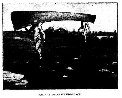
of the "water-ways" which were
connected by "carrying places,"
by the French called
"portages."
It is the purpose of this paper to set
out as accurately as
we can, the main thoroughfares which
were traveled by the
Aborigines in their savage forays, and
by whom they were first
|
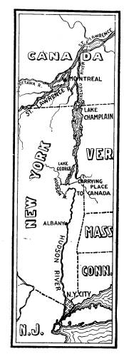
360 Ohio Arch. and Hist. Society Publications. seen and traversed by white men. Miss Lucy Elliot Keeler has aptly denominated these highways as "the roads that run." Champlain had learned from the Indians that there was an ample water-way from the St. Lawrence to the Atlantic at the present port of New York and the intention was to ascend the Richelieu, which is the outlet of the waters of Lakes George and Champlain, and by carrying their birch canoes from the head of those waters over the "carrying place" to reach the waters of |
|
|
|
Hudson River as they flowed down from the Adirondack Moun- tains, and so surprise and destroy the villages of the Iroquois in the Mohawk Valley. But the plan failed, as when near the head of Lake Champlain they unexpectedly met with a strong war party of the Iroquois when a battle ensued in which Cham- plain and his Indian allies were successful and vanquished their enemies with great slaughter. This was the first time that fire arms had been used in Indian warfare among the northern In- |
Water Highways and Carrying
Places. 361
dians, and the Iroquois were so
terrifiedby the noise and deadly
execution of fire arms in the hands of
the Frenchmen that they
fled in every direction and were pursued
and slaughtered in great
numbers by the savage allies of
Champlain. Soon after this
decisive battle, Champlain and his
Indian allies returned to the
St. Lawrence, from whence he sailed for
France, and the In-
dians returned to their own country. He
was, however, again
on the St. Lawrence the next spring
(1610) where he had engaged
to meet the Hurons and Algonquins near
the mouth of the Rich-
elieu River. Champlain arrived in
advance of his Indian allies,
and encamped awaiting their coming.
While waiting there, word
was received by him that the Hurons had
surrounded a barricade
of one hundred Iroquois, near the mouth
of the Richelieu, where
a desperate battle was being waged. He
and the Indians with
him hurried to the assistance of the
Hurons. The barricade was
stormed and all the warriors within were
killed or taken prisoners.
Not one escaped. After this battle
Champlain arranged to re-
turn to France but with the agreement to
return the next spring
(1611).
It was further arranged that the Hurons should take
the young man Brule to their far off
Huron country and that
Champlain was to take with him to France
a young Huron (Sav-
ignon), selected by his tribe for that
purpose. They were to
meet again in June, 1611, and
exchange hostages. This was
accordingly done.
In this year spent with the Hurons Brule
had acquired
their language and habits of life and
was able thereafter to act
as an interpreter for Champlain in his intercourse with the Hu-
rons and Algonquins both as to war and
trade.
Champlain made in all ten visits to the
St. Lawrence from
1603 to 1633, during which time he had
learned from the Indians
much concerning the lakes and rivers of
the north-west, but as
for himself he discovered or first saw no lakes or rivers of im-
portance except Lake Champlain and the
Richelieu River. He
wandered far and wide in many directions
but it cannot be claimed
for him that he was the original first white man to discover or
see any of these great natural highways
except as before men-
tioned. In all his wide wanderings, Brule
seemed to have been
in advance of him. Nevertheless. Champlain is entitled to the
362
Ohio Arch. and Hist. Society Publications.
credit, in large part at least, for
directing the discoveries made
by Brule.
Champlain has been frequently and
generally accredited with
being the first "white man" to
see the waters of Lake Ontario,
but this claim cannot be allowed, as it
is surely incorrect. In
fact, it can have no support, except
upon the assumption that the
explorations of Brule were the
explorations of Champlain.
In the month of September, 1615,
Champlain had concen-
trated his few Frenchmen and many
Indians of the Huron and
Algonquin tribes at Lake Simcoe in the
Huron country, with a
view of invading the country of the
Iroquois, but before the war-
riors had all assembled, Brule with
twelve Hurons was dispatched
to notify the Carantouans, who were
allies of the Hurons and
other Canadian tribes, and who had
promised to assist them in the
invasion of the Iroquois country.
Lake Simcoe is directly north from the
mouth of the Humber
river, near where the city of Toronto
now stands. It was but
three or at most four days' travel for
Brule and the Indians with
him to reach the upper or western end of
Lake Ontario and by
crossing that end of the lake they would
be within the Iroquois
country at or near the mouth of the Niagara
River; and so if
they were fortunate enough to escape the
fierce Iroquois, while
passing through their country, would
reach the Carantouan vil-
lages by the shortest and quickest route
possible.
The Carantouan Indians were at that time
living on the
upper waters of the Susquehanna in
northern Pennsylvania.
Brule and his Indian escorts reached the
Carantouan villages
without mishap or delay--and urged that
tribe, friendly to the
Canadian Indians and relentless enemies
of the Iroquois, to fur-
nish five hundred warriors, which they
had promised, to join
with Champlain and his allies in an
attack upon Onondaga village.
Brule set out from Lake Simcoe, directly
south, on the 8th
of September, 1615, and some days later,
Champlain with his
Indian allies started for the mouth of
the Trent River, which
is near where the city of Kingston,
Canada, now stands. Brule's
route took him direct to the mouth of
the Humber river (Toronto).
That they traveled with all speed and
haste may be assumed, as
their mission was to notify the
Carantouans to be present near
Water Highways and Carrying
Places. 363
the village of Onondaga by the time that
Champlain should reach
this important stronghold which was the
objective point of the
expedition. Champlain and his allies on
the other hand had a
much longer and more difficult route.
They were required to
take with them canoes for the entire
party so as to cross the
numerous streams and small lakes which
intervene between Lake
Simcoe and the mouth of the Trent River.
They were also re-
quired to stop at different times in
order to procure a supply of
game and fish for their sustenance.
Brule reached the Caran-
touan villages without hindrance or
delay, but the Indians were
slow in assembling, and with their
feasting and dancing always
incident to going to war much delay was
had and he was not
able to bring them to the point of
attack until Champlain and
his Canadian Indians had been repulsed
at the above named
village. Champlain's retreat was by the
same line by which he
came, and he finally reached the Huron
country where he was
compelled to spend the winter with them
on the shores of Lake
Huron (now called Georgian Bay).
"The roads that run" had
been congealed into ice and the thawing
suns of spring had to
be awaited.
Brule reached the mouth of the Humber
and stood upon the
banks of Lake Ontario many days, if not
weeks before Champlain
reached the mouth of the Trent River
near Kingston, from which
point he first viewed the waters of
Ontario. The route taken
by Brule with his Indian guides to Lake
Ontario was less than
half the distance of the route taken by
Champlain, and it is certain
that Brule not only saw Lake Ontario but
crossed it before Cham-
plain had reached the mouth of the Trent
river. Both Champlain
and Brule had long been familiar with
the fact that such a lake
existed but neither of them had before
that time seen its waters.
The best and shortest route from the
Huron country to Ontario
and the St. Lawrence was that which
Brule took to reach Lake
Ontario and thence along the north side
of that lake to its outlet,
and thence along the descending waters
of the St. Lawrence to
Montreal and Quebec. But in the time of
war between the In-
dians in Canada and the Iroquois this
route could not be used
except in such force as to be able to
contend with such parties
of hostile savages as might be met. This
is what caused the
|
364 Ohio Arch. and Hist. Society Publications. Hurons and Algonquins to adopt the long, difficult and cir- cuitous route of the Ottawa, Lake Nipissin and the French River |
|
|
in order to reach their homes along the borders of Lake Huron and Lake Simcoe. This great water-way leading from the waters of New York Harbor to the St. Lawrence is about four hun- dred and fifty miles in length, with only seven or eight miles of portage or "carrying place." The Hudson river furnishes about one hundred and fifty miles of this water-way, and lakes George and Champlain and the Richelieu about three hundred miles. It was a singular coincidence that at the same time Champlain was ex- ploring and making war on the wa- ters of the lake which bears his name, Henry Hudson, an English naviga- tor, was exploring the waters of the Hudson river which bears his name, so in the same year this entire water- way was made known to Europeans. The Hudson river was not, as is generally assumed, discovered by Hudson, but by Giovanni da Verraz- zano in 1524, who was sailing under a commission from Francis I. of France. Verrazzano sailed into what is now the port of New York and some little distance up the Hudson. This was eighty-five years before Henry Hudson saw that stream. In |
|
the meantime the French fur traders had penetrated that river at least as far as the present city of Albany, but it was not until the year 1609 that the entire water-way from the St. Lawrence to the port of New York became known to Europeans. |
Water Highways and Carrying
Places. 365
For what thousands of years this great
route was known
and used by the Aborigines can never be
known, but certainly
from the remote time when human beings
came to inhabit that
part of the country. Since the coming of
white men with a view
of possessing the country, there has
been innumerable war expe-
ditions conducted along this great water
route between the French
and their Canadian allies and the
English and their allies, the
Iroquois. Important battles and
massacres and conflicts, of every
nature, have since that time taken place
on these waters and along
their shores. It is not within our
purpose to enumerate even im-
portant war expeditions, but we will be
pardoned for recalling
a few of the later and more important
engagements which took
place, in which "white men"
were engaged, as showing the im-
portance of this route as considered by
the French and English
and the people of our colonies.
On the 16th of April, 1755, a commission
was issued to Col.
William Johnson of New York, appointing
him major general of
the forces to be sent by this route to
Canada to expel the French
from Crown Point, where they had
strongly entrenched them-
selves. Sir William was to have in his
commnad 3,500 colonists
and British, and 1,000 Indians. He
commenced his forward
movement early in August, 1755, and on
the 14th of August
arrived at Fort Edward where he was
joined by 250 more In-
dians. In the meantime Baron Dieskau, in
command of the
French and their Indian allies, was
marshalling his forces to resist
the incursion of Sir William and his
army.
On the 7th of September the forces met
and a desperate
battle ensued, which, after varying
fortunes, resulted in favor of
Sir William and his forces. Sir William
and Baron Dieskau
were both wounded and the latter was
taken prisoner and sent
to New York and thence to England. He
was succeeded in com-
mand by Montcalm, who, on July 8, 1758,
with 3,600 men suc-
cessfully defended Ticonderoga against
the British General Aber-
crombie who assaulted that place with
14,000 men,
of which he
lost 2,000 killed and wounded.
This water-way was also the route taken
by Gen. Robert
Montgomery in command of the continental
troops in the invasion
366 Ohio Arch. and Hist.
Society Publications.
of Canada in 1775. He succeeded in
taking all the forts on these
waters and along the St. Lawrence until
he reached the City of
Quebec, which was the great objective
point, where, in an assault
made upon that stronghold December 31st,
1775, his forces were
repulsed with heavy loss, General
Montgomery being among the
dead.
General Burgoyne was placed in command
of the British
Canadian forces in America when he
arrived early in 1777. He
came with a large British (Hessian)
force of about 8,000 troops
to the St. Lawrence River where he
invited the Indians to
join him, many of whom did so. He
advanced along the line
of the Richelieu and Lake Champlain and
Lake George, until
he reached the headwaters of the last
named lake, with a view
of taking possession and holding the
line of the Hudson River,
but his plans were frustrated. He was
hindered, delayed and
defeated at Stillwater, New York,
September 19th, and again
at Freeman's Farm, October 7th, and was
compelled to surrender
with his whole army near Saratoga,
October 17, 1777. So it will
be seen that this great highway from the
waters of the St. Law-
rence to the waters of the Atlantic at
New York has been, within
historic times, a great military
highway.
Henry Hudson was most fortunate in
having his name
stamped upon this important river. Not
only the Hudson river
received his name, although not
discovered by him, but Hudson's
Bay and Hudson's Strait will forever bear
his name, although he
was not the original discoverer or
navigator of either.
It is certain from maps and charts of
former navigators,
particularly that of Sebastian Cabot,
that Hudson's Bay had been
entered and partially explored nearly a
hundred years before
Hudson entered those waters. It was on
this voyage to Hud-
son's Bay that he met his sad fate. The
ship's crew mutinied
and placed him and his son and seven of
the seamen in an open
boat and set them adrift on the desolate
and gloomy waters of
Hudson's Bay. No trace of them was ever
found, although
when the facts became known in England a
searching expedition
was sent out to look for them. They
undoubtedly perished in the
waves of that storm-swept and lonely
sea.
Water Highways and Carrying
Places. 367
E'TIENNE (STEPHEN) BRULE'.
As we have before seen Stephen Brule
came to Quebec in
1608 which was the second visit of
Champlain to the waters of
the St. Lawrence. He was with Champlain
at the battle on
the lake now known by that name, in 1609. He remained
on the
St. Lawrence during the winter of 1609-10, when he
again joined
Champlain in a war expedition, and
participated in the battle of
June, 1610, near the mouth of the
Richelieu River, where a
hundred Iroquois who had barricaded
themselves, were entirely
destroyed by Champlain and his Indian
allies. In June, 1610,
he went to spend a year with the Hurons
in their country on the
waters of Lake Huron at the foot of what
is now called Georgian
Bay. His route was up the Ottawa River
to the mouth of the
Mattawan, thence up that stream to the
"carrying place" leading
to Lake Nipissing, thence across that
lake to its overflow the
French river, thence down that river to
the waters of Lake Huron,
andthence along the east coast of that
great lake to the country
of the Hurons. Brule was certainly the
first "white man" or
European that ever passed over any part
of that long and diffi-
cult route or saw any of these lands or
waters. In the spring
of 1611, he returned by the same way,
when the Indians came to
barter their furs on the banks of the
St. Lawrence and to ex-
change him for "Savignon" the
young Indian whom Champlain
had taken to France the year before.
In July (1611) Champlain returned to
France and Brule
remained among the Indians of Canada for
two years and until
Champlain's return in 1613. During this
time he roamed far
and wide in the wilds of the Indian
country.
In 1615 Champlain was again on the St.
Lawrence and agreed
to go with the Hurons and Algonquins to
the Huron country with
a view from there of invading the
Onondaga country which was
in the very center of the Iroquois
tribes. Their principal village
was in the vicinity of Oneida Lake, New
York. The place of
assembling was Lake Simcoe in the Huron
country and about one
hundred miles north of the present city
of Toronto.
As we have before seen, Brule separated
from Champlain
and his army and left them at Lake
Sincoe, and with two birch
368 Ohio Arch. and Hist.
Society Publications.
canoes and twelve Indians for an escort,
descended by way of
numerous small lakes and other waters to
the mouth of the Hum-
ber River. This was to the Indians a
well known highway by
which Lake Huron and Lake Ontario were
connected, and, except
in times of war, was the best and most
desirable route from the
Huron country to the St. Lawrence. Brule
crossed the upper
end of Lake Ontario to a point at or
near the Niagara River
and from thence passed entirely through
the Iroquois country to
the upper waters of the Susquehanna, in
Pennsylvania. After
the defeat at Onondaga, of Champlain and
his allies, Brule was
compelled to retrace his way to the
Carantouan villages.
During the winter of 1615-1616, the
restless spirit of Brule
impelled him to explore the Susquehanna
to its mouth where it
empties into the Chesapeake Bay from
which he returned again
to the Carantouan country, and the next
spring the Carantouans
gave him an escort of five or six
warriors to act as guides to
pilot him back to the Huron villages. He
was taken prisoner
by the Senecas while passing through
their country and narrowly
escaped death by torture. However, he
ingratiated himself with
the Senecas, and the next spring (1617)
returned to his Huron
friends. Here he seems to have rested
and occupied himself
in the Indian fashion of hunting and
trapping until the next
spring (1618), when he returned with the
Hurons as they went
to the St. Lawrence to trade. Here he
met Champlain, from
whom he had been separated for almost
three years, and related
to him his various and remarkable
adventures. In the last named
year Champlain returned to France, but
Brule remained among
the Indians. Champlain says of him that
he had at that time been
"eight years with the Indians"
and had acquired their various
languages.
When, in 1618, Brule had arrived from
the Indian country
and met Champlain at Three Rivers on the
St. Lawrence, he was
urged by Champlain to continue his
exploration to the northward
and westward from the mouth of the
French river from which
country they had received reports of
copper mines and had in
fact seen specimens of copper which the
Indians brought from
that country. It is probable that in the
summer of 1618 or 1619
he went north along the North Channel to
the country of the
|
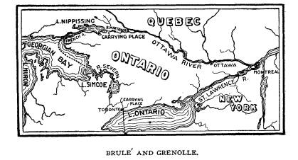
Water Highways and Carrying Places. 369 Beavers, who then had their homes in the region east of the falls of the St. Mary's. In the summer of 1821 he was again on the St. Lawrence from which he returned to the Huron country where he met his future companion and fellow voyager, Grenolle. The following diagram will sufficiently indicate the lines which Brule traveled as the first "white man." |
|
|
|
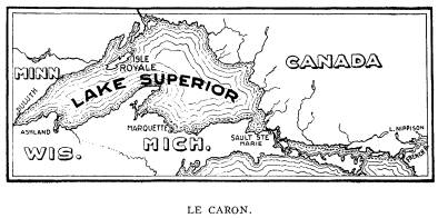
In 1621 Brule was again in the Huron country from which place with a companion, a young Frenchman named Grenolle, he started for an extended exploration to the north and west with a view of ascertaining the character not only of the lakes and rivers and Indian tribes but to locate if possible the copper mines of which they long had been informed existed in that country. Leaving the Hurons they urged their canoe past the mouth of the French river and proceeded northward past the Manitoulin islands along the North Channel to the falls of St. Mary's. The entire distance from the mouth of the French river to the falls of St. Marys was unexplored (unless by Brule in 1618 or 1619) and to Europeans unknown, except by such in- definite and vague reports as they might have received from the Indians. There is but little that is definite about this expedition to Lake Superior, but as they were on an expedition of general discovery with the intention of enlarging the geographical knowl- edge of the white man, it cannot be supposed that two such ven- Vol. XIV.- 24. |
370 Ohio Arch. and Hist. Society Publications.
turesome spirits as Brule and Grenolle
would have stopped short
at the falls of St. Mary's. They would
naturally and necessarily
want to know more about the waters
beyond from which this
vast overflow of clear, cold water came,
rushing over one of
the most stupendous and beautiful rapids
in the world. Stand-
ing on the banks of the rapids they
necessarily looked out upon
the waters of Lake Superior and so were
the first white men to
see and discover the greatest fresh
water body on the globe.
They were gone on this expedition for a
period of two years,
which would give them ample time to have
reached the head or
western end of Lake Superior where are
now the cities of Du-
luth and Superior. The exact point,
however, to which they
urged their canoe is not known, but as
one of their main objects
was to solve the question as to the
"North Sea," now known as
Lake Superior, it is impossible to
suppose that they stopped short
of their main purpose. That they went on
the waters of Lake
Superior to a nation that, to some
extent at least, worked the
copper mines, of which they had
previously heard, there can be
no doubt, as they brought back with them
a large ingot of copper
which could not have been had short of
the region of Lake Su-
perior. It is strong evidence of their
having reached the extreme
head of Lake Superior that the Indians
say that the journey
from the Huron country was thirty days,
while Brule reported
it as four hundred leagues, showing that
Brule's estimate was
his own and not what he had learned from
the Indians.
The historian Sagard says that Grenolle
reported "that a
nation living one hundred leagues from
the Hurons worked in
a copper mine and that he had seen among
them several girls
who had the ends of their noses cut off
having committed
offenses against chastity."
Sagard (one of the early priests to
visit the Huron waters)
who met and traveled with Brule and
Savignon on their return
trip down the Ottawa, says of Brule
"that this bold voyager, with
a Frenchman named Grenolle, made a long
journey and returned
with an ingot of red copper and with a
description of Lake Su-
perior who defined it as very large,
requiring nine days to reach
its upper extremity and discharging
itself into Lake Huron by
a fall."
|
Water Highways and Carrying Places. 371 It is possible and even probable that Brule was the first white man to see the stupendous falls of Niagara. He was in that im- mediate vicinity at least on two occasions as early as 1615-16, which was before any other European had visited that region. It may be assumed that Brule, who was so intensely inclined to see all objects and places of interest, would not have allowed Niagara to escape him. The last few years of Brule's life he remained entirely with the Hurons, who in 1632 for some unknown cause barbarously murdered him after a residence among them of more than twenty years. Their savagery did not stop at his death. It is most revolting says Parkman, that "In their wild and horrible ferocity to take vengeance on their victim, they feasted upon his lifeless remains." The following diagram will sufficiently indicate the lines which Brule and Grenolle traveled as the first "white men." |
|
|
|
For more than two hundred and fifty years Friar Joseph Le- Caron received credit generally for having been the first white man to pass up the Ottawa and the first to discover the waters of lakes Nipissing and Huron, and it is only of late years that this error has been corrected. Modern investigation has shown that he was entitled to no such distinction. He in fact discovered noth- ing whatever which added to the geographical knowledge of the country. He was a devout and zealous priest in the Catholic Church, and ardently anxious to convert savages to his faith, but |
372
Ohio Arch. and Hist. Society
Publications.
he was in no sense an explorer and
deserves no credit as such.
He did not leave France until May, 1615,
and in due time arrived
at Quebec with three other priests of
the Catholic Church. He
was assigned to establish a mission
among the Hurons, many of
whom were then near Montreal where they
had come to trade
with the French, and he went direct to
that place. Champlain
had arranged with the Indians there
assembled to join them in
a campaign against the Iroquois before
mentioned. LeCaron
had nothing whatever to do with that
expedition, but finding the
Hurons having finished their bartering
with the French traders
on the St. Lawrence, were about to
return to their own country
preparatory to their campaign against
the Iroquois, he determined
to accompany them. He had no connection
with the intended
incursion into the country of the
Iroquois. That had been ar-
ranged for by Champlain and the Indians,
and LeCaron simply
availed himself of the opportunity to
obtain access to the Huron
villages with a view only of propagating
his religious faith. The
Indians with whom LeCaron traveled left
the St. Lawrence on
the first of July, 1615. It
was necessary for Champlain to post-
pone his departure for a few days, but
on the 9th of July, he, with
Brule and another French lad (probably
Grenolle) left the St.
Lawrence to join in the expedition
against the Iroquois. He
reached the Huron country a few days
after LeCaron and the
Indians with whom he traveled, but Brule
had been for five years
in that country and had made yearly
trips with the Hurons to the
St. Lawrence along the route of Lake
Nipissing and the Ottawa
river, and was as familiar with the
route and the country as the
Indians themselves.
Years before LeCaron ever saw an Indian,
Brule had lived
with them and had acquired the language
of different tribes in
the regions where he had been; and he
went along now with
Champlain as his interpreter of the
languages of the various
tribes. The claim as to LeCaron was
based upon nothing more
substantial than the fact that the
Indians with whom he traveled
reached the Huron country a few days in
advance of Champlain.
Most of the early writers concerning the
history of that time
mention Brule as having gone to live
with the Indians in the
summer of 161O, but they seem to have
fallen into the habit of
Water Highways and Carrying
Places. 373
not considering him in their narrations.
But when it comes to
naming the "first European" or
"white man" in connection with
these explorations and discoveries Brule
cannot be ignored, but
must be given place in history which
rightly belongs to him.
LeCaron left the Huron country in the
spring of 1616, as
soon as the waters were free from ice.
He was only a few months
in that country during which time he was
attending to his relig-
ious duties and made no incursions or
discoveries. Brule had
left him there when he went on the
campaign against the Iroquois
and when he returned to the Huron
villages, Le Caron had been
gone from that country more than a year.
JOHN NICOLET.
John Nicolet, a young Frenchman, arrived
at Quebec in the
spring of 1618 and was immediately sent
by Champlain to the
Ottawa country to learn the language in
use among the Ottawa
tribes. He remained with them two years,
during which time
he saw not a single white man.
Subsequently he made his home
for several years with the Nipissings
from whence he was re-
called by the government to the St.
Lawrence and employed as
an interpreter and commissary. He went
again among the In-
dians where he remained from 1629 to 1632. This
was during
the time that Quebec was in the
possession of the English, from
which place he held himself aloof and
remained away during
that time in the remote country of Lake
Nipissing. He returned
to the St. Lawrence in 1633 and the next
year (1634) was se-
lected by Champlain to go upon an
exploring expedition to the
regions further west than had yet been
visited by white men.
The expedition was in the interest of
the "Association of one
hundred" who desired to enlarge
their knowledge of the Indian
tribes and country with a view of
extending the fur trade, of
which they then had a monopoly. A still
further object was to
locate, if possible, the copper mines of
which they had heard
so much from Brule and Grenolle and the
Indians around the
upper lakes. Nicolet was selected to
make a venture into this,
at that time, unknown country except as
to such information as
they had received from the natives. They
had heard of the
374 Ohio
Arch. and Hist. Society Publications.
Winnebagoes who were at that time
located west of Lake Mich-
igan, and Nicolet was especially
instructed to visit them and also
any other tribes who might be found in
that region.
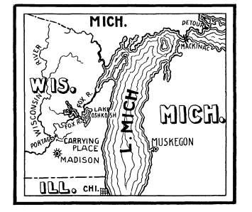
It was in 1634 that Nicolet started on
his mission. He pur-
sued the usual route by way of the
Ottawa, Nipissing and the
French river, and at the mouth of the
French river he turned
north and west as Brule and Grenolle had
done thirteen years
before. He held his way along the north
shore of the Huron
waters to the falls of St. Marys, as
Brule and Grenolle had done.
From the falls he turned south along the
St. Mary's river to
where it enters the waters of Lake
Huron, and from that point
commences his original explorations and
discoveries. He pro-
ceeded along the north shore of Lake
Huron, past the Straits
of Mackinaw, around the north and west
shores of Lake Michi-
gan until he entered the waters of Green
Bay. From Green Bay
he proceeded up the waters of Fox River
to near the carrying
place from that stream to the waters of
the Wisconsin river and
there ended his original or first
"white man's" discoveries.
Nicolet returned to the St. Lawrence and
was employed in
important relations mostly at Three
Rivers and Quebec until 1642,
when he lost his life by the upsetting
of a boat in which he was
hurrying on a mission of mercy to save
an Iroquois from being
tortured by the Algonquins who had
captured him.
Nicolet was a devout Catholic but not a
Jesuit. His life
and character and conduct in his
intercourse with the numerous
Indian tribes was such that they all
reposed the greatest confi-
dence in him in life and entertained the
highest respect for his
memory of which their natures were
capable.
The diagram on page 376 will in a
measure show the route
of original discovery to which Nicolet
is entitled to credit.
JOLIET.
In 1669, Talon, then Intendant of
Canada, sent Joliet with
a young French companion to explore and
locate if possible the
copper regions of Lake Superior. He
failed in his mission in
so far as the copper regions were
concerned, but they made a
most important excursion over waters
that had not before that
|
Water Highways and Carrying Places. 375 time been reached or seen by any European. On their return from the northern lakes, they coasted down the west shore of Lake Huron and visited the Pottawattamies then living on that shore. The Pottawattamies had, at that time, never seen a white man. From the Pottawattamie country they coasted on down the west shore of Lake Huron to the point where the waters of that lake flow south through the St. Clair and Detroit rivers. From there these daring explorers held their way with the current |
|
|
|
of these rivers until they reached the waters of Lake Erie. Thence they proceeded along the northern coast of Lake Erie to the mouth of the Grand River not far west of Niagara Falls. They turned up Grand River (now the home of the Senecas) and proceeded to a point near the present city of Hamilton, On- tario, where they met LaSalle and the Sulpitian priests. They were the first Europeans to navigate or see the waters along the route which they took from the northern end of Lake Huron to a point near the city of Hamilton. The information which they imparted to LaSalle and the priests as to the waters over which |
|
376 Ohio Arch. and Hist. Society Publications. they had just passed, and the condition of the Pottawattamie nation determined the priests to go at once to that country as a field for the exercise of their religious proclivities. It was here that they parted with LaSalle who held firmly to his purpose of exploring the Ohio River country. Joliet and his companions are entitled to be considered the first white men or Europeans to pass over any portion of these waters over which now passes by far the greatest commerce of any inland waters in the world. The following diagram will indicate the lines of original travel taken by Joliet and his companion. |
|
|
|
In 1672, Frontenac, then Governor of Canada, and Talon, the Intendant, determined to send an expedition to the regions further west than had yet been visited by white men and to search out and locate the great Mississippi river and to learn as much |
Water Highways and Carrying
Places. 377
as possible of any tribes that they
might meet with. Their pur-
pose was largely mercenary, their object
being to secure a knowl-
edge of new tribes and new regions so as
to enlarge the fur trade
on the St. Lawrence. Jolliet was
selected by them for this ser-
vice, for which he was in the highest
degree fitted. He had been
born at Quebec and brought up in the
wilderness of the lake coun-
try and was intelligent, hardy and
daring, thoroughly versed in
the habits of the Indian tribes. He had
already made long ex-
cursions to the lake country and had
made valuable discoveries
of new routes of travel by water and of
new tribes of Indians.
He was to have associated with him
Father Marquette who had
seen service as a missionary at the
falls of the St. Mary's and at
LePoint (Apostles Islands) on the south
side of Lake Superior.
While stationed in these places as a
priest of the Catholic Church,
Marquette had learned much concerning
Lake Michigan and the
Mississippi and Illinois rivers. He had
come in contact with
numerous members of the tribes occupying
the vast region to the
south and west of Lake Superior and
greatly desired to explore it.
Joliet reached Mackinaw on this
expedition in the fall of
1672 with instructions to Marquette to
join him in the proposed
venture which gave great pleasure to the
ardent priest, as it
was in harmony with his own desires.
They spent the winter
in preparing for the journey and in
informing themselves as fully
as possible concerning the regions and
tribes they were to visit.
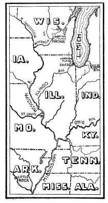
On the 17th of May, 1673, they embarked
in two canoes with
five men. These two frail canoes were
destined to carry them
from "the snows of Canada to the
more congenial clime of Ar-
kansas" and to tide them over
thousands of miles of water which
had never before been disturbed by a
white man's canoe. From
Mackinaw around the north and west shore
of Lake Michigan
they passed over the same route which
had been traveled by Nico-
let thirty-nine years before until they
reached the waters of Green
Bay. From there they ascended the Fox
river to the carrying
place from the waters of that river to
waters of the Wisconsin
river. This carrying place was near the
point at which Nicolet
had turned back. It was but a mile and a
half from the waters
of one river to the waters of the other,
but the way was so intri-
378 Ohio Arch. and Hist. Society Publications.
cate through the vast field of wild rice
which grows in such abun-
dance in that region as to require the
services of Indian guides
to pilot the way through them. When they
reached the waters
of the Wisconsin they dispensed with
their guides and proceeded
for six days to descend the Wisconsin to
its mouth where it empties
into the mighty Mississippi. When their
canoes shot out on the
waters of that the greatest of rivers on
the continent the adventur-
ers were greatly rejoiced, and well they
might have been as they
had at last discovered and were upon the
waters of the long
sought for Mississippi. The voyagers
turned south with the
current of the river and proceeded for
more than a thousand
miles. They passed the mouth of great
rivers emptying into the
Mississippi and found many tribes of
natives inhabiting the shores,
most of whom proved friendly. They did
not change their course
until they had reached the mouth of the
Arkansas river where
DeSoto had crossed the Mississippi 132
years before. At this
point they were able to determine that
the Mississippi flowed
into the Gulf of Mexico which was an
unsettled question up to
that time. From this point on the 17th
of July, 1673, they com-
menced their return up the Mississippi
and proceeded with great
difficulty and considerable delay on
account of the illness of Mar-
quette until they reached the mouth of
the Illinois, into which
they turned their canoes and urged them
up that placid stream
to the important Indian village of
Kaskaskia. They found the
people of this very important village
friendly, and after some stay
there, the Indains kindly piloted them
up to the mouth of the Des
Plaines, up which they proceeded to the
carrying place over into
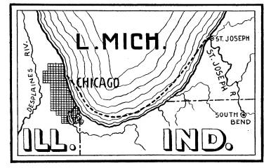
the Chicago river. They then coasted up
the west shore of Lake
Michigan to Green Bay which they had
left four months before.
Jolliet proceeded at once to the St.
Lawrence while Marquette
remained at Green Bay.
Marquette and Joliet are entitled to
credit for having been
the first white men to pass from the
carrying place between the
Fox river and the Wisconsin to the mouth
of the Arkansas and
on their return from the mouth of the
Illinois to the mouth of
what is now the Chicago river, thence
along the western coast
to Lake Michigan to Green Bay.
|
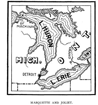
Water Highways and Carrying Places. 379 The following diagram will show, in a manner, the routes over which Marquette and Jolliet are entitled to be considered the original navigators and explorers. |
|
|
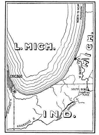
FATHER JAMES MARQUETTE. When Marquette and Joliet reached Green Bay in the fall of 1673 the former was in in- firm health and rested at Green Bay for nearly a year, but his health being in part restored he determined to re- turn to the Illinois river as he had promised the Indians he would do. The course taken by Marquette and associates, two of whom were French, was along the west side of Lake Michigan to the mouth of the Chicago river. He pur- sued the route from that point to some distance inland where he suffered a relapse and was compelled to spend the winter in a rude hut constructed by his French companions. They suffered greatly during the winter, but in the spring of |
|
1674, Marquette renewed his efforts to reach his Indian friends on the Illinois with a view of establishing a mission among them. He succeeded in this and was most joyfully received by the natives. He administered religious instruction to them for a short time, but his health was such that he was required to make an effort to return to his mission at S. Ignace. A number of Indians accompanied him up the Illinois river to the mouth of the Kan- kakee; thence up that lonely and crooked stream for several hun- dreds of miles until they reached a point near where is now the |
380
Ohio Arch. and Hist. Society Publications.
city of South Bend, Indiana, where there
was a short carrying
place of about four miles from the
Kankakee over to the head-
waters of the St. Josephs of Lake
Michigan, and there it seems
the Indians left him. From there he,
with his two French com-
panions, floated down that river to its
mouth where it empties
into the east side of Lake Michigan.
From this point his faith-
ful escorts proceeded for several days
north along the east shore
of Lake Michigan until his strength
entirely failing him, and
himself realizing that death was upon
him, requested his com-
panions to take him on shore that he
might die in peace. His
every request was complied with. A rude
shelter was prepared
for him where, after a few days and
nights of devotion, he passed
peacefully away, and was buried at the
place of his death on
the desolate and lonely east shore of
Lake Michigan.
In reviewing the lives and characters of
the priests of the
Catholic Church who energized among the
Indians of that time,
or of any time, Marquette was clearly
the most celebrated and
most beloved by the Indians. He died in
1674 at the age of 38
years, but his name has a permanent
place in the history of his
times.
The two French companions of Marquette
on his last voy-
age proceeded to Mackinaw, which place
they reached in safety
and are entitled to be considered the
first Europeans to coast along
the eastern shore of Lake Michigan from
the point where Mar-
quette was buried to the Straits of
Mackinaw.
The diagram on page 382 will
sufficiently show the route
taken by Marquette on his return from
the Illinois river in 1674.
This route had never before been
traversed by white men.
LA SALLE.
La Salle came to Montreal from France in
1666. His equip-
ment for whatever experiences he might
have in his career in
the New World was that he was well
fitted mentally and physi-
cally to meet whatever fortunes or
misfortunes might befall
him. His ambition and his courage were
unbounded and not
unmixed with greed of gain. He had
visions not only of wealth
but of dominion and empire. Before his
time extensive explo-
|
Water Highways and Carrying Places. 381 rations had been made, but he soon learned from contact with the Indians, especially the Senecas, a party of whom had wintered at his quarters in 1668-69, of still vaster regions that were as yet unexplored and unseen by white men. He heard especially of |
|
|
|
the waters of the Ohio, some of which headed in the Seneca country and to which his Seneca friends offered to guide him. He knew that the waters of the Ohio would reach the great Miss- issippi river and finally flow into the sea, but where and into what |
382 Ohio Arch. and Hist. Society
Publications.
sea was the great mystery. It is
probable that his hope in this
first exploration to the Ohio country
was that he might reach
the Mississippi; and in all probability
he would have done so
had his crew remained loyal to him.
This expedition was organized in 1669 at
LaChine, near
Montreal. At the same time the Sulpitian
priests at LaChine
were organizing an expedition for the
purpose of searching out
and converting to their faith such
Indian tribes as they might
find in the unknown country of the Ohio.
The two expeditions
were united in the beginning. LaSalle
had procured four canoes
and seven men, while the Sulpitians had
their own canoes and
their own men. The members of this
expedition were all French-
men and would have to procure guides
from the Indians when
they reached the upper end of Lake
Ontario. On the 6th of
July, 1669, they proceeded up the St.
Lawrence river to Lake
Ontario and along the south shore of
that lake to a point not
far east from the mouth of Niagara river
where the expedition
rested while LaSalle visited the village
of the Senecas with a
view of obtaining guides to the Ohio. He
failed to secure guides,
as he had hoped, and as the season was
getting late the expedition
again moved forward along the south
shore of Lake Ontario,
past the mouth of the Niagara river and
proceeded until they
reached an Indian town near where the
city of Hamilton, Canada,
now stands. While at this village he learned of two young
Frenchmen being near by, and there for
the first time Joliet and
LaSalle met. Joliet, as before stated,
was returning from the
expedition which he had undertaken at
the instance of Talon in
search of the copper regions of Lake
Superior. This meeting
caused a separation of La Salle's party
from the missionary party.
Joliet told them of the Pottawattamies
who greatly needed relig-
ious instructions, and the missionaries
determined to go at once
to their spiritual rescue while LaSalle
adhered to his original pur-
pose of visiting the valley of the Ohio.
The home of the Potta-
wattamies was at that time in the
country west of Lake Huron.
It is conclusive that Joliet in
returning from his search for
copper mines in 1669 coasted the west
shore of Lake Huron for
the reason that he visited the
Pottawattamies and reported their
spiritual condition to the priests who
were with LaSalle when
|
Water Highways and Carrying Places. 383 they met near the head of Lake Ontario. The Pottawattamies occupied the country west of Lake Huron and in order to visit them Joliet necessarily had his course along the west shore of that lake. The missionaries failed in their purpose to reach the Pot- tawattamies, but passed up the eastern side of Lake Huron, and |
|
|
|
the north channel until they reached the falls of St. Marys, from which place they returned by the way of Lake Nipissing and the Ottawa to the St. Lawrence, having discovered nothing and ac- complished nothing. LaSalle succeeded in carrying out, in large part, his original plan. Just what course he took after separating from the missionaries is not known with entire certainty, but it |
|
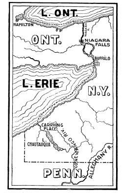
384 Ohio Arch. and Hist. Society Publications. may be assumed that he passed near the head of Niagara river and along the south and east side of Lake Erie to a point oppo- site Chautauqua Lake. From Lake Erie to Chautauqua Lake there was a well known and much used carrying place of about eight miles. From there the route was over the waters of Chau- tauqua Lake to its outlet near Jamestown, New York, from where the overflow waters, united with the other streams, flow |
|
|
|
into the Alleghany river near Warren, Pennsylvania, and thence descend to the Ohio. It was by this route that the French sub- sequently sent a force two hundred strong to take possession of the Ohio. Not much is recorded of this excursion of LaSalle except that it extended down the Ohio to the falls at Louisville, Ken- tucky. Here most of his men deserted him and he was compelled to return almost if not entirely unaccompanied. His way of re- turn has not been definitely determined, but it was necessarily by way of the Big Miami and the Maumee (then called Miami |
Water Highways and Carrying
Places. 385
of the Lake) or by way of the Scioto and
Sandusky rivers. No
other routes were at that time opened to
him. Whichever of these
routes he may have taken he was the
first white man to have
passed over it. The probabilities are
that he went by the Big
Miami and the Maumee to Lake Erie, but
it is not certain, and
not much can be claimed in respect to
it.
Between the ending of this expedition
and the undertaking
of his next important voyage of discovery
there elapsed a period
of about nine years. In the meantime he
was exceedingly en-
gaged with important affairs along the
St. Lawrence and in
France, to which country he had in the
meantime made several
voyages.
In 1679 he planned a voyage over Lake
Erie, through the
Detroit and St. Clair rivers and over
Lakes Huron and Michigan
with a view of reaching and exploring
the Mississippi river, as
well as engaging in the fur trade. In furtherance of this plan
he built on the Niagara river above the
falls a vessel of forty-
five or fifty tons with which to
navigate the great lakes. They
named the vessel the
"Griffin." There were three friars of the
Sulpitian order in the party that sailed
on the "Griffin," among
whom was Father Hennepin, a man of
considerable learning and
a ready and somewhat graceful writer,
and had considerable
talent for describing places where he
had never been and things
that he had never seen. He immortalized
himself by stories
which he related and books which he
published when he re-
turned to France which have secured for
him, for all time to
come, the appellation of "the most
impudent liar." Nothing
could exceed his audacity in this
respect.
The expedition started in the summer of
1679 from the
Niagara river and passed safely over
Lake Erie, Lake Huron
and through the Straits of Machinaw
until they reached Green
Bay on the waters of Lake Michigan. Here
the vessel was
loaded with a rich cargo of furs, and
LaSalle sent it back to
Niagara in charge of his pilot and five
men. The vessel was
never heard of afterwards. It was lost
somewhere between Green
Bay and its destination the Niagara
river. From this point (Green
Bay) LaSalle determined to push forward
to the Illinois country,
and in pursuance of this purpose passed
down the west shore of
Vol. XIV.- 25.
|
386 Ohio Arch. and Hist. Society Publications. Lake Michigan and around the south end to the St. Joseph river. From Green Bay to the mouth of the Chicago river the route had been traversed by Marquette and Joliet several years before; but from the mouth of the Chicago river to the mouth of the St. Joseph, LaSalle and his party were the first white men to traverse it. From the mouth of the St. Joseph to the mouth of the Illinois, and on to the mouth of the Arkansas river the route had all been explored before this expedition of LaSalle. When LaSalle and his party reached Illinois country he determined to build a fort |
|
|
|
and establish a camp as a basis for further explorations. But from this place LaSalle was compelled to return to Lakes Erie and Ontario, leaving the colony on the Illinois in charge of his faithful Tonty with instructions as to its conduct and manage- ment in his absence; and at the same time he instructed Hennepin to proceed down the Illinois to its junction with the Mississippi and to make such other and further explorations as opportunity might afford. In the meantime, pursuant to the instructions of LaSalle, Hennepin with two French companions (Michael Accau and a man known as Picard du Gay), proceeded to the mouth of the Illinois, thence up the Mississippi to the mouth of the Wis- consin. From their starting point on the Illinois to the mouth of |
Water Highways and Carrying
Places. 387
the Wisconsin they passed over waters
that had before that time
been explored by Marquette and Joliet.
From the mouth of
the Wisconsin, however, to the falls of
Minnehaha, near the
present city of Minneapolis, he and his
companions were the first
white men to explore that part of the
Mississippi river. They
were taken prisoners by the Sioux
Indians somewhere in that
country and were for some time detained
by them, but were
finally released and Hennepin returned
to the St. Lawrence by
way of the Wisconsin river, Mackinaw,
Nipissing, and the Ot-
tawa. From the St. Lawrence he returned
to France where
he wrote and published volumes of
stupendous lies which made
him famous at the time and infamous for
all time. He has se-
cured immortal fame in history both as a
liar and a plaguerist.
As soon as LaSalle had established his
camp and fortified
himself in a strong position, which
fortification he gave the name
of Crevacoeur, he returned to Fort Miami
at the mouth of the
St. Joseph at the southern end of Lake
Michigan, and from
there he made a journey on foot with his
five French com-
panions across the southern portion of
the State of Michigan to
Lake Erie and on to Fort Frontenac at
the foot of Lake Ontario;
but it is not within our purpose to
follow him in the strenuous
life which befell him until he
reappeared at the mouth of the St.
Joseph late in the year 1682, where he
made final preparations
for an expedition intended to reach the
mouth of the Mississippi.
On December 21st, he dispatched Tonty
and Membre from Fort
Miami at the mouth of the St. Joseph
with a part of his force
in six canoes. They crossed from the
mouth of the St. Joseph
to the mouth of the Chicago where
LaSalle joined them a few
days later. From the Chicago river over
to the Des Plaines
there was a carrying place of a few
miles, but at this time those
streams were frozen and LaSalle and his
companions were com-
pelled to construct sheds and put their
canoes and baggage on
them in order to cross from the Chicago
to the Des Plaines which
was and is the north branch of the
Illinois. They followed the
course of the Des Plaines to its
junction with the Kankakee and
thence down the Illinois to the site of
the Illinois village which
they found deserted. From there they
found the river free from
ice and proceeded with their canoes down
the Illinois river until
388
Ohio Arch. and Hist. Society Publications.
on the 6th of February they reached its
mouth where it empties
into the Mississippi. They tarried here
for a few days and then
commenced the descent of the great
river. They stopped at the
various Indian villages with a view of
learning as much as pos-
sible concerning them and of cultivating
friendly relations with
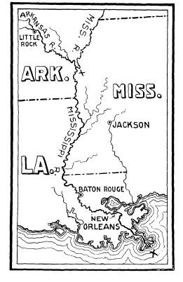
them. They in time reached the mouth of
the Arkansas where
they found a considerable Indian
village. This was at the point
where DeSoto and his followers first saw
and crossed the Miss-
issippi 141 years before and which had
been reached by Marquette
and Joliet nine years before. The
Mississippi had not been ex-
plored from that point to its mouth. On
the 31st of March they
passed the mouth of the Red River where
in 1542 DeSoto died
and was buried with all his ambition and
greed of gold and treas-
ures. The rich cities he hoped to find
and plunder as he and other
Spaniards had done in Mexico and Peru
were never found and
his visions of plunder and wealth
vanished into nothingness.
On the 6th of April, LaSalle and his
companions reached the
point where the river divides itself
into three channels, through
which its mighty waters rush into the
Gulf of Mexico. These
were all explored until they reached the
sea, "then the broad
bosom of the great gulf opened on his
sight, tossing its restless
billows, limitless, voiceless, lonely as
when born of chaos, with-
out a sail, without a sign of
life." (Parkman.)
In the discovery of the mouth of the
Mississippi, LaSalle had
reached the consummation of an ambition
which he had long and
ardently entertained. It would seem that
he might well have been
satisfied with what he had accomplished
in the eighteen years since
he left France, and it would have been
well for him had he been
content to rest upon the laurels which
he had gained by his stren-
uous efforts in exploring and making
known the important water
highways of the interior of the
continent. He and his associates
had aided very materially in making
known to the world the
highways and carrying places by which
the Aborigines traveled
for thousands of years. The entire
distance from the mouth of
the St. Lawrence to the mouth of the
Mississippi was more than
4,000 miles which had been traversed by
means of birch canoes,
urged on by energetic adventurous white
men. He was not sat-
isfied, however, and immediately
returned to France filled with
|
Water Highways and Carrying Places. 389 the idea of returning by sea to the mouth of the Mississippi and establishing there a military colony in the furtherance of French interests. Aided by government, he organized an expedition and sailed for the mouth of the Mississippi but miscalculating the latitude and longitude sailed past the mouth of that river and landed some distance west of that point. It is not our prov- ince to follow him further. He wandered far and wide over land, hoping to discover the great river, but he failed and on or near the Brazos river in the State of Texas, he was foully mur- dered by one of his own men. The original explorations to which LaSalle is entitled as the first "white man" to have traversed are, first, from a point near the Niagara river to the waters of the Alleghany and thence |
|
|
390 Ohio Arch. and Hist. Society
Publications.
down that stream to the Ohio and on to
the falls where the city
of Louisville now stands; second, the
route by water from the
mouth of the Chicago river around the
south end of Lake Mich-
igan to the mouth of the St. Joseph; third,
from the mouth of the
Arkansas to the mouth of the
Mississippi. But these discoveries
in no wise represent the explorations
and discoveries which his
mighty energies prompted.
Champlain in his time and LaSalle in his
time were the main
springs of most of the discoveries of
the waters and countries
in the great basin which lies between
the western slope of the
Alleghanies and the eastern slope of the
Rocky Mountains and
the Great Lakes on the north and the
Gulf of Mexico on the south.
It is not at the present day generally
appreciated that these two
energetic, able and ambitious Frenchmen
came near establishing
a French empire in the New World
embracing this entire ter-
ritory.
BETWEEN LAKE ERIE AND THE OHIO RIVER.
There were three starting points on Lake
Erie by which the
Aborigines in their time, and the white
men in more modern
times passed from the waters of Lake
Erie to the waters of the
Ohio River. These were all very
important and much used as far
back as we have either history or
tradition. There were prac-
tically direct lines of canoe travel
with but few carrying places
on any of them so that the Aborigines
could pass easily from
one of these waters to the other.
The first we have to mention commenced
at the mouth of the
Cuyahoga river where the city of
Cleveland now stands, thence
up that river to a point near the city
of Akron in Summit County,
Ohio, where there was a carrying place
of about eight miles from
the waters of the Cuyahoga to the waters
of the Tuscarawas and
south with that stream to the Muskingum,
and thence along that
majestic river to its junction with the
Ohio. It is not known
who the first European or white man was
to pass over this route,
but no doubt it was first traveled by
French fur traders or voy-
agers. The ubiquious fur trader was everywhere present, in the
immediate wake of the original
explorers, but they left no records
of their travels or excursions. The main
lakes and rivers were
visited by them soon after their
existence was made known.
Water Highways and Carrying
Places. 391
As early as 1668, Joliet traversed, as
has before been seen,
Lake Erie and the Detroit and St. Clair
rivers; and the next
year a few Sulpitian priests traveled
over the same route, only
going in the other direction, and from
that time all the waters
were made known to the French traders.
On LaSalle's return
from his exploration of the Ohio in
1670, all that country was
made known and soon invaded by the
rapacious and unscrupulous
fur traders, so that we may safely
assume that all the waters of
Lake Erie and the waters leading from
Lake Erie to the Ohio
were traversed by them, and that they
must be considered as
the first white men to invade these
waters; so that it is almost
certain that the Cuyahoga and the
Muskingum and the Scioto
routes and the Maumee were all known and
often used by the
French traders prior to the time of
which we have any authentic
record.
THE SCIOTO AND SANDUSKY RIVERS.
The next important highway between Lake
Erie and the
Ohio river commenced at the mouth of the
Sandusky river and
proceeded south against the current of
that historic stream to a
very noted carrying place about six
miles east of the present city
of Bucyrus in Crawford County. This
carrying place was but
four miles long and was the only
carrying place between Lake
Erie and the Ohio river. When this route
was first traveled by
white men is not known, but like others
it was undoubtedly by
the French traders at a period long
prior to any written record
concerning this route. The first written
description that we have
was by Col. James Smith, who, in the
summer of 1755, was taken
prisoner by the Indians. He passed from
the mouth of the San-
dusky to the carrying place in Crawford
County. From there
he went with his captors to the south
west as far as the Olen-
tangy, now called the Darby. He and his
Indian companions
spent the winter of 1757 in the
neighborhood of what is now Plain
City, Madison County, and the next
spring they descended the
Darby to the point where it empties into
the Scioto river near
Circleville, Ohio, from which point they
ascended the Scioto to
the carrying place in Crawford County,
and thence by way of
the Sandusky and Lake Erie to Detroit.
His very interesting
392 Ohio Arch. and Hist. Society Publications.
and important narrative furnished the
first description that has
been preserved of the country between
Pickaway County and the
mouth of the Sandusky river.
THE MAUMEE, THE MIAMI AND THE WABASH.
From the mouth of the Maumee, the Ohio
could be reached
at two widely different points, the one
at the mouth of the Big
Miami, and the other at the mouth of the
Wabash; but who first
traveled these waterways is like the
last two mentioned, unknown.
Lake Erie and the Detroit river, and the
surrounding regions,
had been discovered and made known as
early at 1669 and '70.
The French trader soon entered into any
new field of barter or
commerce with the Indians which was
opened to them; and by
the year 1700 the French interests about
Lake Erie and the
Detroit river, and other streams in that
region had come to be
so important that it was deemed
necessary by the French author-
ities to give it a military protection,
and so in 1701, Cadillac, a
French officer, was sent with fifty
soldiers from the St. Lawrence
to establish a post at the present city
of Detroit. He arrived
at that point July 24th, 1701. At that time there were both
French and English traders around the
waters of Lake Erie
and the Detroit and other rivers, so
that it is certain that, at that
early date, there was not only French
traders in that region, but
that their interests were so
considerable that it was thought nec-
essary to protect it by military force.
There are facts as well as
traditions which go to show that the
Maumee had been traversed
by the French trader as early as 1690, but who the first trader or
voyager was will always remain unknown.
The waters of the
Ohio could be reached from the Maumee
either by ascending the
Auglaize or by ascending the St. Mary,
and thence by carrying
places to the waters of the Big Miami
which empties into the
Ohio at the southwest corner of the
State of Ohio.
Another very important way to the Ohio
was up the Maumee
to a point near Fort Wayne, thence by a
carrying place of eight
or nine miles to Little river one of the
head-waters of the Wabash.
This led to the Ohio river at the
southwest corner of the State
of Indiana. We know that this route was
traveled by the French
at a very early day, and French trading
posts had been established
|
Water Highways and Carrying Places. 393 |
|
|

|
394 Ohio Arch. and Hist. Society Publications. as far south as Vincennes; but it is not easy to fix dates for these events. In 1778 the English general, Hamilton, passed over this route with his army of about three hundred soldiers and Indians, and established himself at the village of Vincennes. He has left a description of the carrying place between the waters of the Maumee and those of the Wabash. This carrying place was about nine miles long, and General Hamilton says of it: "We arrived at one of the sources of the Wabash, called Little river. The stream was so uncommonly low that bateaux could not have |
|
|
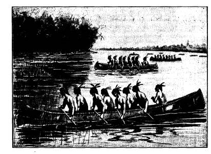
|
floated but for the fact that, some distance below, a beaver dam kept up the water. This they cut through to give a passage to their boats, and, having taken in the lading at the landing, they passed them all." He further says: "This carrying place is free from obstructions but what the carelessness and ignorance of the French have left and would leave from generation to gen- eration. An intelligent person, at a small expense, might make it as fine a road as any within twenty miles of London. The woods are beautiful; there are oak, ash, beech, nut-wood, very |
Water Highways and Carrying
Places. 395
clear and of a great growth." (Butterfield's Conquest of the
Illinois, 208.)
Subsequently very important events took
place along this
water highway, but they are not within
the scope of our present
purpose.
The foregoing paper is mainly based upon
the following
authorities: Bancroft's History U. S.,
Weare's Cabot's Discovery
of North America; Moore's Northwest
Under Three Flags; Cad-
wallader Colden's History of Five Indian
Nations; Brule's Dis-
coveries, by Butterfield; Nicolet's
Discoveries, by Butterfield;
Shea's Discovery and Exploration of the
Mississippi; Buell's Sir
William Johnson; John Fiske's Discovery
of America; "Captain
Pote's Journal;" Parkman's LaSalle,
and The Discovery of the
Great West; Parkman's The Pioneers of
France in the New
World; Butler's Lake George and Lake
Champlain; Ketchum's
History of Buffalo; Darlington's Col.
James Smith; Weise's His-
tory of the City of Albany;
Butterfield's George Rogers Clark's
Conquest of the Northwest; Drake's Book
of the Indians; Per-
kin's Western Annals; Hall's Memoir of
William H. Harrison;
Simpkin's History of Auglaize County;
Knapp's History of the
Maumee Valley; Slocum's History of the
Maumee River Basin;
Prescott's Mexico and Peru; Parkman's
Jesuits in North America;
Narratives of Marquette, Allonez, Membre
and Hennepin.